
Click for full-size.
Mitchell's National Map of the American Republic or United States of North America. Together with Maps of the Vicinities of 32 of the Principle Cities and Towns in the Union
by MITCHELL, Samuel Augustus Sr
- Used
- Condition
- See description
- Seller
-
New York, New York, United States
Payment Methods Accepted
About This Item
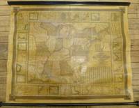
Philadelphia: S. Augustus Mitchell, 1844. unbound. Map. Wall map on linen with wooden scrolls. 31.5" x 48.75"<br/><br/> Large scale map of the eastern United States surrounded with insets of major harbors and towns. Elaborate border design with national coat of arms placed in the each corner contributes to its official quality. Population tables listed in three different insets plus an inset map of the Treaty of 1842, also called Webster-Ashburton Treaty settling a border dispute between Maine and New Brunswick. Large Iowa Territory and Minnesota is not yet named showing impending Westward expansion. From the "National Map Series" that Mitchell produced by subscription over a series of years. Original color but heavily varnished as issued. Samuel Augustus Mitchell Sr. (1792-1868) is one of the pioneers in American cartography of the 19th century and led the conversion of engraved map plates to more affordable lithographic plates. Drawn by James Henry Young (1817-1866) and engraved by J.H. Brightly, both collaborated with Mitchell on this series of maps.<br/><br/>
Reviews
(Log in or Create an Account first!)
Details
- Bookseller
- Argosy Book Store
 (US)
(US)
- Bookseller's Inventory #
- 260312
- Title
- Mitchell's National Map of the American Republic or United States of North America. Together with Maps of the Vicinities of 32 of the Principle Cities and Towns in the Union
- Author
- MITCHELL, Samuel Augustus Sr
- Format/Binding
- Unbound
- Book Condition
- Used
- Quantity Available
- 1
- Publisher
- S. Augustus Mitchell
- Place of Publication
- Philadelphia
- Date Published
- 1844
- Keywords
- Wall map, Indian
Terms of Sale
Argosy Book Store
All items are offered net, subject to prior sale. Returns accepted within 7 days of receipt--please contact us first. Payment by Visa , Mastercard & American Express. Appropriate sales tax will be added for all N.Y. State residents
About the Seller
Argosy Book Store
Biblio member since 2004
New York, New York
About Argosy Book Store
We are a large retail store, with 6 floors of out-of-print and rare books, (including, Americana, modern first editions, history of medicine and science), antique maps and prints, autograph manuscripts, letters & signatures.
Glossary
Some terminology that may be used in this description includes:
This Book’s Categories

What is a professional bookseller?
Just about anyone can sell a book, but a professional bookseller knows the ins and outs of the rare book trade. Learn more!

Collecting One Book
Instead of collecting by series, author, publisher...why not just one title? Learn more about collecting variations and editions of one book.