Frankfurt Airport (FRA)
Orientation and Maps
(Frankfurt Am Main, Germany)
With a population of more than 650,000 and an impressive infrastructure to match, the city of Frankfurt Am Main (Frankfurt-on-the-Main) lies on the western side of central Germany. Full of skyscrapers and impressive architecture, Frankfurt is one of Germany's top cities for finance and commerce, hosting many important trade fairs throughout the year.
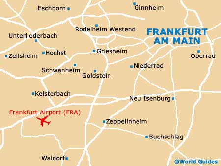
Located in the Hesse province, Frankfurt has long been the country's premier transport hub and boasts two busy airports, with Frankfurt Airport (FRA) being the nearest of the two, lying on the south-western outskirts. The airport is a major place to change planes and many people visit the city for just short stays, before flying off to their next destination.
Also close to the city in the Hesse area are a number of smaller towns, which include Mainz and Rüsselheim to the west, and Offenback am Main to the east.
Frankfurt Airport (FRA) Maps: Important City Districts
Frankfurt am Main has gained itself many nicknames over the years, including 'Bankfurt', on account of its financial importance. This city is actually home to the Bundesbank, which is the central bank of Germany, and also the European central Bank.
Despite its glitzy appearance, with the skyline being full of eye-catching skyscrapers, central Frankfurt is surprisingly compact and easy to explore. Divided by the Main River, the northern region of Frankfurt has long been the traditional centre, while the southern region is based around the appealing Sachsenhausen district.
Germany Map

Frankfurt Map


© TravelSmart Ltd: Airports Guides - Copyright and Privacy Policy 2000-2015
Frankfurt, Germany - Frankfurt Airport (FRA) Maps - 3/3/2016