
Pula
City of Pula
Grad Pula Città di Pola | |
|---|---|
 Aerial view | |
|
Flag .svg) Coat of arms | |
| Coordinates: 44°52′N 13°51′E / 44.867°N 13.850°E | |
| Country | Croatia |
| County | Istria County |
| Government | |
| • Mayor | Boris Miletić (IDA) |
| Area | |
| • City | 51.65 km2 (19.94 sq mi) |
| Elevation | 30 m (100 ft) |
| Population (2006) | |
| • City | 62,080 |
| • Density | 1,093.27/km2 (2,831.6/sq mi) |
| • Metro | 90,000 |
| Time zone | UTC+1 (CET) |
| • Summer (DST) | UTC+2 (CEST) |
| Postal code | 52100 |
| Area code | 52 |
| Website | http://www.pula.hr/ |
Pula (Latin: Pietas Iulia) is the biggest city in Istria County, Croatia. It has a population of about 62,000 people as of the year 2006. It has a long tradition of winemaking, fishing, shipbuilding, and tourism. Its most famous attraction is the well-preserved Roman ampitheatre. Pula is also an administrative center of Istria since Roman times.
-
 The Arena (colosseum) in Pula
 -
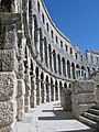 The Arena (colosseum) in Pula
 -
 Temple of Roma and Augustus


Other websites[change | change source]
![]() Media related to Pula at Wikimedia Commons
Media related to Pula at Wikimedia Commons
| International | |
|---|---|
| National | |
| Geographic | |
| Other | |