


![National Geographic Road Atlas 2024: Adventure Edition [United States, Canada, Mexico]](https://images-na.ssl-images-amazon.com/images/I/71KaWaWuVjL._AC_UL160_SR160,160_.jpg)
![National Geographic Road Atlas 2024: Scenic Drives Edition [United States, Canada, Mexico] (National Geographic Recreation At](https://images-na.ssl-images-amazon.com/images/I/814R4OsGtCL._AC_UL160_SR160,160_.jpg)


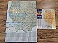
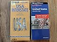
Laminated Interstate Maps: Borch vs Rand McNally.
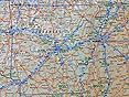
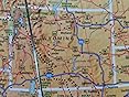
Both great maps, choose which size and level of detail is right for you. In the photos Rand McNally has white state borders.
Borch has grey state borders.
Borch:
Bigger map when fully opened.
More detail, shows 2x or more state routes compared to Rand McNally.
No gaps in the map along the folds.
Has more overlap on each side. For example, Oklahoma is fully shown on the west side of the map and then also shown 80% on the east side of the map.
Rand McNally:
More compact map when fully opened.
Better color scheme, easier to see interstate highways but shows less than half the state highways compared to the Borch map.
Has gaps along the folds.
Less overlap on each side.
The perfect map for me would be the size and detail of the Borch with the color scheme of the Rand McNally.
Loading your book clubs
There was a problem loading your book clubs. Please try again.
Not in a club? Learn more

Join or create book clubs

Choose books together

Track your books
Bring your club to Amazon Book Clubs, start a new book club and invite your friends to join, or find a club that’s right for you for free.
Download the free Kindle app and start reading Kindle books instantly on your smartphone, tablet, or computer - no Kindle device required.
Read instantly on your browser with Kindle for Web.
Using your mobile phone camera - scan the code below and download the Kindle app.


Similar items that may ship from close to you
Page 1 of 1 Start overPage 1 of 1
Reviews with images
Laminated Interstate Maps: Borch vs Rand McNally
Laminated Interstate Maps: Borch vs Rand McNally.Both great maps, choose which size and level of detail is right for you. In the photos Rand McNally has white state borders.Borch has grey state borders.Borch:Bigger map when fully opened.More detail, shows 2x or more state routes compared to Rand McNally.No gaps in the map along the folds.Has more overlap on each side. For example, Oklahoma is fully shown on the west side of the map and then also shown 80% on the east side of the map.Rand McNally:More compact map when fully opened.Better color scheme, easier to see interstate highways but shows less than half the state highways compared to the Borch map.Has gaps along the folds.Less overlap on each side.The perfect map for me would be the size and detail of the Borch with the color scheme of the Rand McNally.
Top reviews from the United States
There was a problem filtering reviews right now. Please try again later.
Reviewed in the United States on May 29, 2019

Both great maps, choose which size and level of detail is right for you. In the photos Rand McNally has white state borders.
Borch has grey state borders.
Borch:
Bigger map when fully opened.
More detail, shows 2x or more state routes compared to Rand McNally.
No gaps in the map along the folds.
Has more overlap on each side. For example, Oklahoma is fully shown on the west side of the map and then also shown 80% on the east side of the map.
Rand McNally:
More compact map when fully opened.
Better color scheme, easier to see interstate highways but shows less than half the state highways compared to the Borch map.
Has gaps along the folds.
Less overlap on each side.
The perfect map for me would be the size and detail of the Borch with the color scheme of the Rand McNally.

Laminated Interstate Maps: Borch vs Rand McNally
Reviewed in the United States on May 29, 2019
Laminated Interstate Maps: Borch vs Rand McNally.Reviewed in the United States on May 29, 2019
Both great maps, choose which size and level of detail is right for you. In the photos Rand McNally has white state borders.
Borch has grey state borders.
Borch:
Bigger map when fully opened.
More detail, shows 2x or more state routes compared to Rand McNally.
No gaps in the map along the folds.
Has more overlap on each side. For example, Oklahoma is fully shown on the west side of the map and then also shown 80% on the east side of the map.
Rand McNally:
More compact map when fully opened.
Better color scheme, easier to see interstate highways but shows less than half the state highways compared to the Borch map.
Has gaps along the folds.
Less overlap on each side.
The perfect map for me would be the size and detail of the Borch with the color scheme of the Rand McNally.
Images in this review


Reviewed in the United States on May 13, 2021
Reviewed in the United States on July 3, 2016
Reviewed in the United States on September 5, 2017
Reviewed in the United States on August 26, 2015
Reviewed in the United States on August 23, 2019


