Hertfordshire
Hertfordshire, on London's northern border, is a predominantly rural county. The countryside is broken up by several market towns like Hertford and Hitchin, large towns like Watford and Stevenage, one cathedral city in St Albans, and dozens of smaller villages.Photo: Doc Searls, CC BY-SA 2.0.
Popular Destinations
St Albans

Photo: Przsak, CC BY-SA 3.0.
St Albans is an English cathedral city to the north of London, in the county of Hertfordshire.

Stevenage

Photo: Traveler100, CC BY-SA 4.0.
Stevenage is a town of approximately 88,000 in the county of Hertfordshire, in the south east of England, around 32 miles north of central London.
Destinations
Hertford
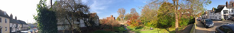
Photo: RobThinks, CC BY-SA 4.0.
Hertford is the county town of Hertfordshire in England and has a population of around 29,000 in 2021.
Hemel Hempstead

Photo: ZIGGY RADWA, CC BY-SA 3.0.
Hemel Hempstead is a town in the Dacorum district in Hertfordshire, England.
Welwyn Garden City

Photo: Cmglee, CC BY-SA 4.0.
Welwyn Garden City is a town) in Hertfordshire, England.
Letchworth Garden City

Photo: RobThinks, CC BY-SA 4.0.
Letchworth Garden City is a town of 33,000 people in Hertfordshire.
Hitchin

Photo: Dudley Miles, CC BY-SA 4.0.
Hitchin is a town with 33,350 inhabitants in 2011 35 mi miles north of London in the county of Hertfordshire.
Hatfield
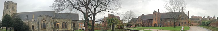
Photo: RobThinks, CC BY-SA 4.0.
Hatfield is a town in the English county of Hertfordshire 20 mi north of London.
Berkhamsted
Photo: Misterzee, CC BY-SA 3.0.
Berkhamsted is an historic market town of 18,500 people in Hertfordshire in England, UK.
Bishop's Stortford

Photo: Thomas Nugent, CC BY-SA 2.0.
Bishop's Stortford is an historic market town in Hertfordshire.
Tring

Photo: AlasdairW, CC BY-SA 3.0.
Tring is a a commuter town of 12,000 people in Hertfordshire, England.
Ware
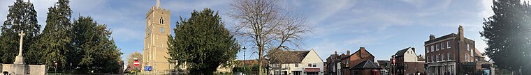
Photo: RobThinks, CC BY-SA 4.0.
Ware is a town in Hertfordshire. The site has been occupied since at least 4000 BC.
Rickmansworth

Photo: Paulblackwell, Public domain.
Rickmansworth is a small town in Hertfordshire, its hinterland includes Chorleywood and the largely suburban Maple Cross.
Royston

Photo: Jo Edkins, CC BY-SA 2.0.
Royston is a town and civil parish in the District of North Hertfordshire and county of Hertfordshire in England.
Potters Bar

Photo: RobThinks, CC BY-SA 4.0.
Potters Bar is a town of 22,000 people in Hertfordshire.
Harpenden

Photo: RobThinks, CC BY-SA 4.0.
Harpenden is a town in Hertfordshire near the border of Bedfordshire.
Kings Langley

Photo: Wikimedia, CC BY-SA 2.0.
Kings Langley is a historic village and civil parish in Hertfordshire, England, 21 miles northwest of central London on the southern edge of the Chiltern Hills and now part of the London commuter belt.
Buntingford

Photo: Nigel Cox, CC BY-SA 2.0.
Buntingford is a market town of 5,000 people in Hertfordshire.
Borehamwood
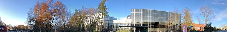
Photo: RobThinks, CC BY-SA 4.0.
Borehamwood and its neighbouring village of Elstree, both in Hertfordshire, are home to Elstree Studios, BBC Elstree Centre and Sky Studios Elstree.
Abbots Langley

Photo: AlasdairW, CC BY-SA 4.0.
Abbots Langley is a large village and civil parish in the English county of Hertfordshire.
Ayot St Lawrence

Photo: Jason Ballard, CC BY 2.0.
Ayot St Lawrence is a small village in Hertfordshire.
Redbourn

Photo: Andrewrabbott, CC BY-SA 4.0.
Redbourn is a village and civil parish in Hertfordshire, England, three miles from Harpenden, four miles from St Albans and five miles from Hemel Hempstead.
London Colney

Photo: RobThinks, CC BY-SA 4.0.
London Colney is a village and civil parish in south central Hertfordshire.
Pirton
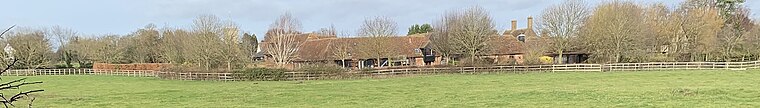
Photo: RobThinks, CC BY-SA 4.0.
Pirton is a large village and civil parish three miles northwest of Hitchin in Hertfordshire, England.
Brookmans Park

Photo: RobThinks, CC BY-SA 4.0.
Brookmans Park is a village in Hertfordshire, southeast England, known for its BBC transmitter station. Brookmans Park railway station, on the East Coast Main Line, is operated by Great Northern.
Hertfordshire
- Type: Region with 1,180,000 residents
- Description: non-metropolitan county in England
- Neighbors: Bedfordshire, Buckinghamshire, Cambridgeshire and Essex
- Categories: ceremonial county of England and non-metropolitan county
- Location: East of England, England, United Kingdom, Britain and Ireland, Europe
- View on OpenStreetMap
Latitude of center
51.8297° or 51° 49' 47" northLongitude of center
-0.217° or 0° 13' 1" westPopulation
1,180,000Elevation
236 feet (72 metres)GeoNames ID
11609037Wikidata ID
Q3410Hertfordshire Satellite Map
© OpenStreetMap, Mapbox and Maxar
Also Known As
- Afrikaans: Hertfordshire
- Arabic: Hertfordshire
- Arabic: هارتفوردشير
- Aragonese: Hertfordshire
- Armenian: Հարթֆորդշիր
- Armenian: Հարթֆորշիր
- Asturian: Hertfordshire
- Azerbaijani: Hartfordşir
- Balinese: Hertfordshire
- Basque: Hertfordshire
- Belarusian: Гартфардшыр
- Belarusian: Гэртфардшыр
- Belarusian: Хартфардшыр
- Bengali: হার্টফোর্ডশায়ার
- Breton: Hertfordshire
- Bulgarian: Хартфордшър
- Catalan: Hertfordshire
- Cebuano: Hertfordshire
- Chinese: Hertfordshire
- Chinese: 赫特福德郡
- Chinese: 赫福郡
- Cornish: Hertfordshire
- Czech: Hertfordshire
- Danish: Hertfordshire
- Dutch: Hertfordshire
- English: Ceremonial County Hertfordshire
- English: Herts
- Esperanto: Hertfordshire
- Estonian: Hertfordshire
- Finnish: Hertfordshire
- French: Hertfordshire
- Galician: Hertfordshire
- Georgian: ჰერტფორდშირი
- German: Hertfordshire
- Greek: Χέρτφορντσιρ
- Gujarati: હર્ટફોર્ડશાયર
- Hebrew: הרטפורדשייר
- Hindi: हर्टफ़र्डशायर
- Hungarian: Hertfordshire
- Hungarian: Herts
- Icelandic: Hertfordshire
- Ido: Hertfordshire
- Indonesian: Hertfordshire
- Interlingua: Hertfordshire
- Irish: Hertfordshire
- Italian: Hertfordshire
- Japanese: ハートフォードシャー
- Kannada: ಹರ್ಟ್ಫೋರ್ಡ್ಶೈರ್
- Korean: 하트퍼드셔주
- Kurdish: Hertfordshire
- Ladin: Hertfordshire
- Latin: Hertfordiensis comitatus
- Latvian: Hārtfordšīra
- Lithuanian: Hartfordšyras
- Luxembourgish: Hertfordshire
- Macedonian: Хартфордшир
- Manx: Hertfordshire
- Marathi: हर्टफर्डशायर
- Min Nan Chinese: Hertfordshire
- Mirandese: Hertfordshire
- Northern Frisian: Hertfordshire
- Norwegian: Hertfordshire
- Norwegian Bokmål: Hertfordshire
- Norwegian Nynorsk: Hertfordshire
- Occitan (post 1500): Hertfordshire
- Old English (ca. 450-1100): Heortfordscīr
- Ossetian: Хартфордшир
- Persian: هرتفوردشایر
- Persian: هرتفوردشر
- Polish: Hertfordshire
- Portuguese: Hertfordshire
- Romanian: Hertfordshire
- Russian: Хартфордшир
- Scots: Hertfordshire
- Serbian: Хартфордшир
- Serbo-Croatian: Hertfordshire
- Sicilian: Hertfordshire
- Slovak: Hertfordshire
- Slovenian: Hertfordshire
- Spanish: Hertfordshire
- Swedish: Hertfordshire
- Tajik: Ҳартфордшир
- Tamil: ஹெர்ட்போர்டஷிர்
- Tatar: Һартфордшир
- Telugu: హెర్ట్ ఫర్డ్ షైర్
- Thai: ฮาร์ตฟอร์ดเชอร์
- Turkish: Hertfordshire
- Ukrainian: Гартфордшир
- Urdu: ہارٹفورڈشائر
- Vietnamese: Hertfordshire
- Volapük: Hertfordshire
- Waray (Philippines): Hertfordshire
- Welsh: Swydd Hertford
- Western Frisian: Hertfordshire
- Western Panjabi: ہرٹفورڈشائر
- Wu Chinese: 赫特福德郡
- Yiddish: הארטפארדשיר
- Yue Chinese: 赫福郡
Popular Destinations in East of England
Discover Cambridge, Norwich, Ipswich and Peterborough.
Escape to a Random Place
Explore your world with these selected destinations of excellence.
About Mapcarta. Thanks to Mapbox for providing amazing maps. Text is available under the CC BY-SA 4.0 license, excluding photos, directions and the map. Description text is based on the Wikivoyage page Hertfordshire. Photo: Wikimedia, CC0.