Home » World Maps » North America » Greenland
Greenland - The World's Largest Island

Where is Greenland?
Greenland is located between the North Atlantic Ocean and the Arctic Ocean. Most of the island is north of the Arctic Circle. The entire island is north of the 10°C isotherm and the arctic treeline. [1]
The main island of Greenland has an area of 822,700 square miles (2,130,800 square kilometers), which makes it the world's largest island. [2] Politically, Greenland (and its surrounding minor islands) is an autonomous territory of the Kingdom of Denmark. [3]
Geologically, Greenland is located on the North American tectonic plate, which drifts atop of the mantle in a northwesterly direction. [4] The mantle hotspot responsible for forming Iceland and causing its volcanic activity was once under Greenland. [5]
ADVERTISEMENT

An Enormous Island Surrounded by Enormous Islands
Greenland is surrounded by other enormous islands. On its west is the Canadian Arctic archipelago, which contains Baffin Island (the world's fifth-largest island) by the Davis Strait, and from Ellesmere Island (the tenth-largest island) by Baffin Bay.
On the east it is separated from Iceland (the 18th-largest island) by the Denmark Strait, and from Spitsbergen (the 36th-largest island) by the Greenland Sea. Newfoundland (the 16th-largest island) is to the southwest. [2]
Greenland Bedrock Altitude and Ice Thickness Maps
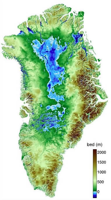
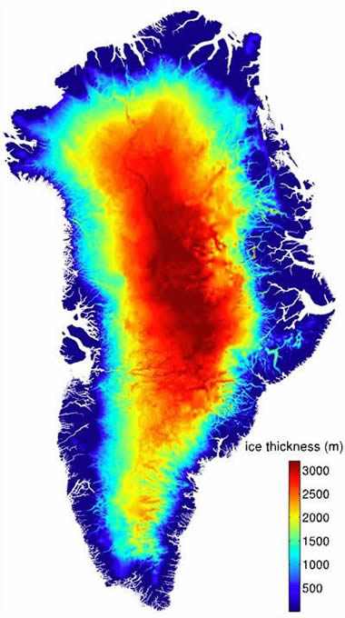
| M. Morlighem, E. Rignot, J. Mouginot, H. Seroussi, and E. Larour. 2015. IceBridge BedMachine Greenland, Version 2. Boulder, Colorado USA: NASA DAAC at the National Snow and Ice Data Center. https://nsidc.org/data/IDBMG4/versions/2 Last accessed June 2020. |
Greenland - The Island of Ice
About 80% of Greenland is covered by a continental glacier, which is the world's second-largest ice mass. At its maximum, the ice is approximately 1.9 miles (3 kilometers) thick. The ice is thickest in the center of the island and slowly flows outwards, towards the sea.
With global climate change, Greenland's glaciers are melting. The meltwater flows into the sea and is a significant contributor to global sea level rise.
Today, the island of Greenland is surrounded by numerous minor islands. However, after climate change causes Greenland's glacial cover to melt, it is likely that many other minor islands will be revealed.
Map of Greenland Municipalities
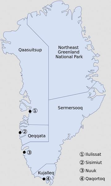
| Administrative divisions of Greenland, with municipal centers. Public Domain image by Algkalv. |
An Enormous Island with a Tiny Population
Greenland has an estimated population of 57,616 people. About 90% are Greenlandic, about 8% are Danish, and the rest are Nordic and other. Most of the country's employment is in the fish and shrimp industry. [3]
An Island with Enormous Mineral Wealth
The mineral resource potential of Greenland is almost unexplored because the island is remote and almost entirely covered by ice. Mineral occurrences mapped by government geologists include: anorthosite, barite, coal, copper, cryolite, diamond, gold, graphite, iron, lead, marble, molybdenum, nickel, olivine, osmium, platinum, rare earth metals, silver, tin, titanium, tungsten, uranium, and zinc. [6]
A working ruby and sapphire mine is located on the island's southeast coast. Significant oil and natural gas resources are thought to be present beneath the seafloor off Greenland's east and west coasts.
Where is Greenland?

| Greenland Information |
|
[1] Where Is the Arctic? What Is Its Boundary? Hobart M King, an article on the Geology.com website, first published July 2019.
[2] List of Islands by Area: an article on the Wikipedia.org website, last accessed October 2022. [3] Greenland: an article on the Wikipedia.org website, last accessed October 2022. [4] Plate Tectonics Map: Hobart M. King, an article on the Geology.com website, first published November 2005. [5] Iceland: Plate Tectonic History: an article published on the Dartmouth.edu website, now hosted on the Internet Archive. [6] Greenland Geology and Selected Mineral Occurrences: a map published on the Government of Greenland website, last accessed October 2022. |
Greenland Bordering Countries:
NoneRegional Maps:
Arctic Ocean Map and Bathymetric Chart, Arctic Ocean Seafloor Features Map, Map of North America, Canada Map, Iceland Map, World MapADVERTISEMENT

Explore Greenland Using Google Earth:
Google Earth is a free program from Google that allows you to explore satellite images showing the cities and landscapes of Greenland and the rest of the world in fantastic detail. It works on your desktop computer, tablet, or mobile phone. The images in many areas are detailed enough that you can see houses, vehicles and even people on a city street. Google Earth is free and easy-to-use.
Greenland on a World Wall Map:
Greenland and nearly 200 countries are illustrated on our Blue Ocean Laminated Map of the World. This map shows a combination of political and physical features. It includes country boundaries, major cities, major mountains in shaded relief, ocean depth in blue color gradient, along with many other features. This is a great map for students, schools, offices and anywhere that a nice map of the world is needed for education, display or decor.
Greenland On a Large Wall Map of North America:
If you are interested in Greenland and the geography of North America, our large laminated map of North America might be just what you need. It is a large political map of North America that also shows many of the continent's physical features in color or shaded relief. Major lakes, rivers, cities, roads, country boundaries, coastlines and surrounding islands are all shown on the map.Greenland Cities:
Ilulissat, Sisimiut, Nuuk, Qaqortoq, Tasiilaq, Ittoqqorttoormiit, Nord, Qaanaaq.
Greenland Locations:
Arctic Ocean, Baffin Bay, Davis Strait, Denmark Strait, Greenland Sea, Labrador Sea, North Atlantic Ocean. Municipalities: Qaasuitsup, Qeqqata, Sermersooq, Kujalleq. Northeast Greenland National Park is not a municipality, but it is the world's largest national park. Highest point: Gunnbjorn Fjeld.
Greenland Natural Resources:
Resources known to exist in Greenland: coal, gemstones, gold, iron ore, lead, molybdenum, niobium, platinum, tantalite, uranium, zinc. Also: fish, seals, and whales.
Greenland Natural Hazards:
The northern portion of the island is covered in permafrost.
Greenland Environmental Issues:
Glacial melting and preservation of the Arctic environment.

ADVERTISEMENT