

Digital maps can find the nearest coffee shop, the boundaries of a neighbourhood or a street view of the house where you grew up. What they can’t find are fundamental pieces of Canadian geography: treaty territories.

Saskatoon city planner Tyson McShane regularly uses Google Maps, where he said treaty areas should be overlaid and searchable.
“It just sort of amazed me that something so foundational to our country and our identity and our geography wasn’t located there,” McShane told Global News.
He said city planning expands beyond land development.
“It’s about the people and the culture and the context,” he said.
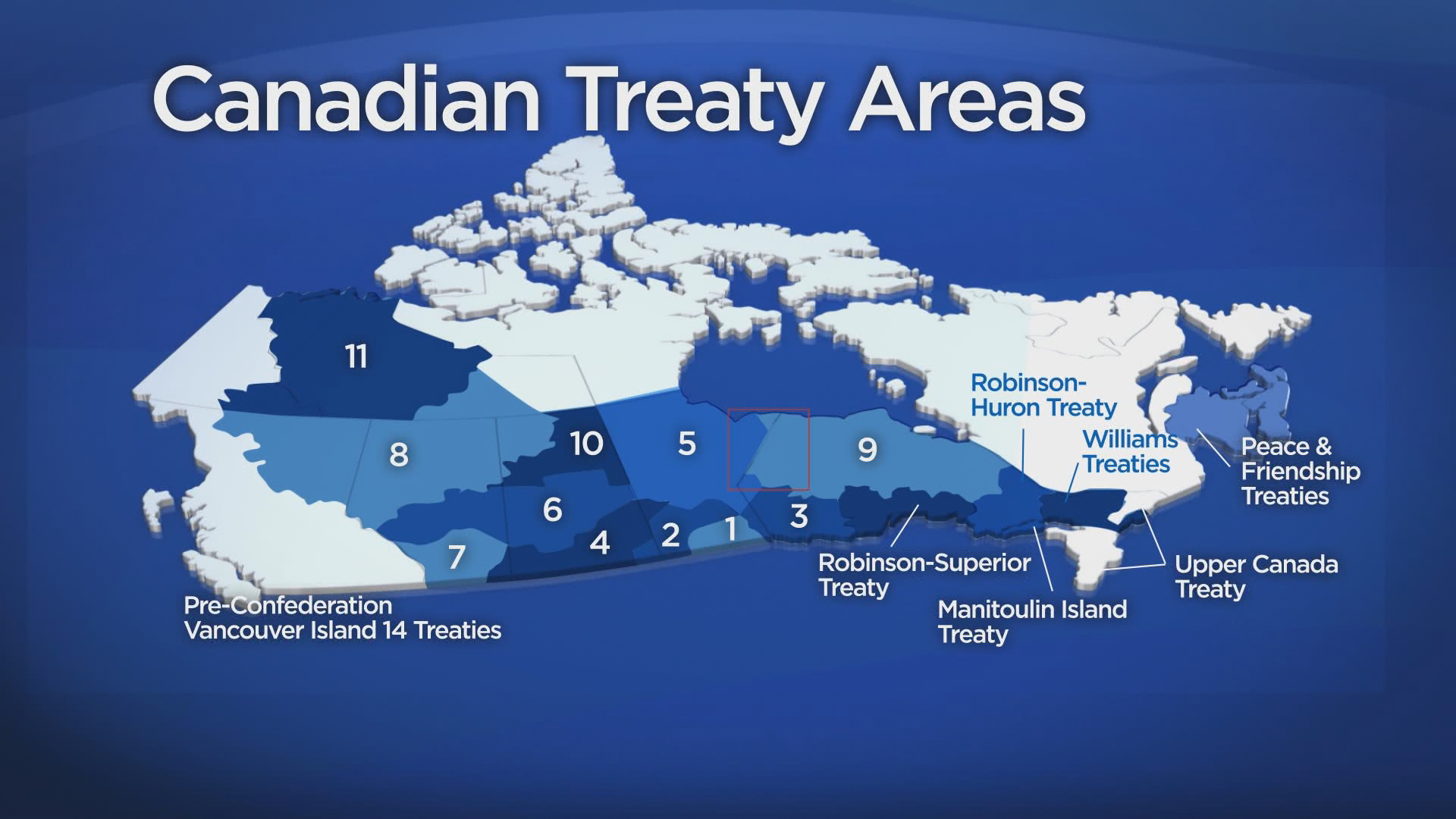
Marking treaty territories on mainstream digital maps would serve as a reminder of the historic agreements between First Nations and the Crown, McShane said.
“We’re all treaty people,” he said. “It’s just one more little thing to remind people that we’re on treaty territory.”
- Life in the forest: How Stanley Park’s longest resident survived a changing landscape
- Bird flu risk to humans an ‘enormous concern,’ WHO says. Here’s what to know
- Mental health support still lacking 4 years after mass shooting: Nova Scotia mayor
- Buzz kill? Gen Z less interested in coffee than older Canadians, survey shows
McShane sent the suggestion to Google, but said he hasn’t heard back. Google did not respond to a request for comment from Global News.
Melody Wood, Indigenous knowledge systems researcher with the Saskatchewan Indigenous Cultural Centre, said the proposal could serve as an educational tool.
“It’s absolutely valuable because you never know who it’s going to reach,” Wood said.
“Some young Indigenous person might be checking out maps, and that will be the thing that speaks to them and that will be the thing that sparks their want to learn more about their culture and their languages.”

A worthy challenge
The Office of the Treaty Commissioner (OTC) for Saskatchewan is keen on the idea, though one researcher said it wouldn’t be an easy task.
“To pinpoint (treaty boundaries) is very difficult because we don’t have a map that does that,” said Sheldon Krasowski, OTC research and archives co-ordinator.
The OTC is working to find the co-ordinates of treaty boundaries, so the province can put up highway signs marking the territory, he said.
It’s a challenge, Krasowski said, as federal treaty maps aren’t exact and boundary descriptions in the written agreements are complex.
The land limits for Treaty 6 are described as: “Commencing at the mouth of the river emptying into the north-west angle of Cumberland Lake; thence westerly up the said river to its source; thence on a straight line in a westerly direction to the head of Green Lake.”
The boundary explanation continues with about a dozen more directions.
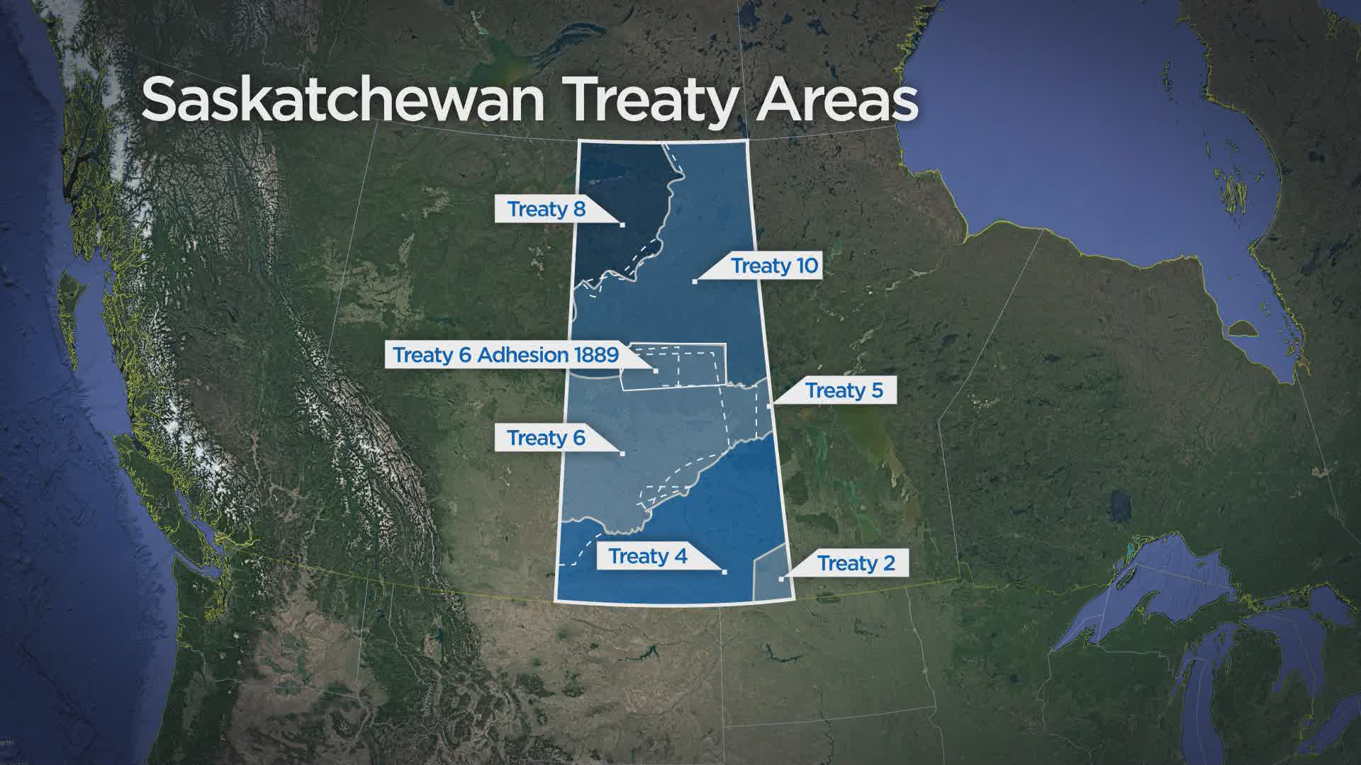
Determining exact treaty limits also requires incorporating oral histories, Krasowski said.
While pinpointing the co-ordinates won’t be easy, he said it’s possible with the help of archives, elders’ knowledge and modern mapping technology.
“In the past, people have… said this is an insurmountable barrier,” he said. “It’s not easy, but we can do it.”
If digital maps eventually mark treaty areas, it’s crucial they also show traditional Métis territory, said Robert Doucette, executive director of the Saskatoon Indian & Métis Friendship Centre.
“Little is told about the historical communities of the Métis people,” said Doucette, who is Métis.
“There is a shared territory. It’s a shared history.”
Doucette said it’s incumbent the contributions of all Indigenous people are acknowledged.
“If we’re ever going to balance our history and have a greater understanding and all move towards reconciliation,” he said, “then the whole story should be told.”

-
![]() ‘Let it be real, let it be lasting’: Siksika councillor cautiously optimistic about policing changes
‘Let it be real, let it be lasting’: Siksika councillor cautiously optimistic about policing changes -
![]() Montreal unveils strategy for reconciliation with Indigenous Peoples
Montreal unveils strategy for reconciliation with Indigenous Peoples -
![]() Indigenous women’s solutions key to Reconciliation
Indigenous women’s solutions key to Reconciliation -
![]() Reconciliation Regina launches community action plan
Reconciliation Regina launches community action plan -
![]() Vocal group Revv52 re-imagines ‘O Canada’ to reflect spirit of reconciliation
Vocal group Revv52 re-imagines ‘O Canada’ to reflect spirit of reconciliation -
![]() Poll: Canadians disapprove of Trudeau’s, premiers’ response to rail blockades
Poll: Canadians disapprove of Trudeau’s, premiers’ response to rail blockades


Comments