


Empty airports on Google Maps

Thread Starter
Join Date: Apr 2007
Location: Lisbon
Age: 53
Posts: 10
Likes: 0
Received 0 Likes
on
0 Posts
Empty airports on Google Maps
Hi,
Do you know why on Google Maps some airports show empty of airplanes like FRA, TXL and others present a realistic view like LHR, CDG?
Do you know why on Google Maps some airports show empty of airplanes like FRA, TXL and others present a realistic view like LHR, CDG?

Join Date: Jul 2011
Location: Edinburgh
Age: 39
Posts: 642
Likes: 0
Received 0 Likes
on
0 Posts
I noticed this too, especially with some of the bigger North American airports.
Looking at the dates of the images they appear to have been updated during the pandemic so that would explain it, with many aircraft being stored elsewhere. I suppose the airspace around airports will have been consistently quiet enough to allow the lower level photography to take place.
Looking at the dates of the images they appear to have been updated during the pandemic so that would explain it, with many aircraft being stored elsewhere. I suppose the airspace around airports will have been consistently quiet enough to allow the lower level photography to take place.
I checked Google Earth. Most large airports show no aircraft at all (its not a question of storage - there aren't any at all but smaller ones may (check PIK, BOH or MLB in Florida). They must have been surgically removed, but I can't think why. Airports are not top secret military installations.
Join Date: Jan 2009
Location: Solihull
Age: 38
Posts: 160
Likes: 0
Received 0 Likes
on
0 Posts
I noticed this with BHX and MAN the other day. Though interesting LHR is full of planes.
Reading a bit more about it, the suggestion is that its not for the purpose of security - after all what would knowing which planes use an airport tell us. Its more to do with the fact that google maps, or any such tool, is meant to be a capture of the land, not the land and cars and trains and planes and people etc. Evidently, clever algorithms have been used to show the land as it should be, rather than with a plane on top of it. Which makes some sense.
I assume it falls off the fact that every bit of land will have multiple shots of it. Thinking of an airport, the system probably crops together multiple images, e.g. one showing gate x empty, the next showing gate y empty and so on. The point being that each image taken will be different if there is a movable object on it. This is probably most notable on train lines - there are very few trains on google maps!
Join Date: Jul 2011
Location: Edinburgh
Age: 39
Posts: 642
Likes: 0
Received 0 Likes
on
0 Posts
I was thinking about this today. Is it possible that aircraft have been removed form the images to prevent what would essentially be a form of free advertising? I know to most people they may not be able to identify an airline from above, but perhaps there was complaints from some that airlines or indeed other companies were benefiting from their logos being seen on street view or on some beneficially angled top down shots. There are lots of examples of adverts being blurred on street view.
Interesting post. How many WW2 airstrips show up on Google Earth or other maps I wonder. When flying over Yorkshire and Lincolnshire I can visually see many of the old strips from FL250.
crewmeal,
1. Load UKAirfields.kmz from here: http://www.rickdavis.co.uk/home/airfields.php
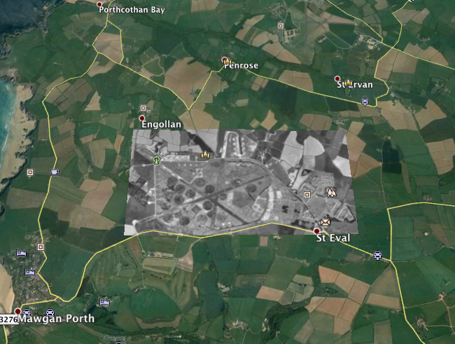
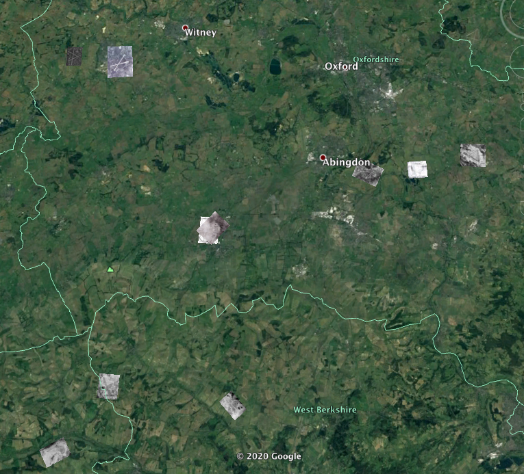
2. I have another .kmz file, for which I cannot find the source, which shows WWII aerial photos of a few airfields. I could upload it to Dropbox if required.
1. Load UKAirfields.kmz from here: http://www.rickdavis.co.uk/home/airfields.php
2. I have another .kmz file, for which I cannot find the source, which shows WWII aerial photos of a few airfields. I could upload it to Dropbox if required.

The Willis & Hollis book lists 654 airfields and I must have looked at almost all of those on GE over the years.
A short answer to that would be "practically all of them". It's in the nature of airfields that it's almost impossible to obliterate all traces of one from the air, even if the runways have been dug up and restored to agriculture.
The Willis & Hollis book lists 654 airfields and I must have looked at almost all of those on GE over the years.
The Willis & Hollis book lists 654 airfields and I must have looked at almost all of those on GE over the years.
Christchurch has a road called "The Runway" but it's not very straight and there is nothing else to see except roads with randomly selected aircraft names.
Join Date: Nov 2007
Location: Berkshire
Posts: 134
Likes: 0
Received 0 Likes
on
0 Posts
Airfields : I like this set up on Google Maps
Again, I like these sort of questions , not sure of a comprehensive answer to the question , anyway I like this set up on Google Maps
- use the zoom in / out , bottom right.
Gives a brief history of the airfield top right , enjoy ;
https://www.google.com/maps/d/viewer...0658203106&z=9
- use the zoom in / out , bottom right.
Gives a brief history of the airfield top right , enjoy ;
https://www.google.com/maps/d/viewer...0658203106&z=9
But even Christchurch has some surviving features - there's enough open space left (just) to be able to deduce the position and orientation of the hard runway, and some of the original Airspeed/de Havilland factory buildings survive. Part of the original grass airfield is now school playing fields and one of the biggest giveaways is the gap in Mudeford Wood through which the taxiway between the factory and the runway used to pass.
Christchurch.
I didn't realise how many of the old buildings survive.
I was living in Mudeford in the early '70s when the roads and housing were being built.
I couldn't understand why the names chosen for the roads were just any old aircraft rather that ones with a local association. The only ones that have local relevance are Airspeed Road and DeHavilland Way.
I lived in Fulmar Road, but this was from a bird theme of the 1950s.
My father worked for DH in 1952 building Venoms.
