
This article is regularly updated with new tips, tricks and techniques.
- GeoGuessr Modes
- Fundamental Techniques
- Highway Numbering Systems
- General Clues
- Meta
- License Plates
- Languages
- How To Identify Every Country In North America
- How To Identify Every Country In Europe
- How To Identify Every Country In Oceania
- How To Identify Every Country In Africa
- How To Identify Every Country In Asia
- How To Identify Every Country In South America
This article is for everyone from the GeoGuessr novice to expert. It begins with the basics then covers all the important elements including identifying: license plates, bollards, utility poles, languages, highway signs, highway numbering systems, camera generations, visible Street View cars and much, much more. The lower section of this article provides the key clues and idiosyncrasies that will help in recognising each country in the (GeoGuessr) world.
An Introduction to GeoGuessr
GeoGuessr (https://geoguessr.com/) is a game in which a semi-random Google Street View location is presented to you. You are permitted to move along the street akin to Google Street View and must use Sherlock-esque logic (not the type of logic used in the recent poorly executed ‘Holmes and Watson’ movie that has a generous 10% on Rotten Tomatoes) to decode precisely where on earth your initial Street View location is. On an adjacent map, you are required to click a location and your guess’s proximity to your actual Street View position is awarded with points. The point score will range from 0 for an antipodean guess, which is hard to achieve in itself, to a maximum 5000 points for a guess within about 150 metres for the standard GeoGuessr game. A GeoGuessr game consists of 5 rounds and if my abacus is calibrated correctly, that means a potentially perfect score of 25,000 awaits.
The primary purpose of GeoGuessr is that it is (everyone say this in unison) “fun and educational”. Other reasons to play involve lauding your geographical superiority nous over your friends or couples settling disputes about who is better at giving directions whilst driving. In pragmatic terms, GeoGuessr may only be useful if you are kidnapped and taken blindfolded to a random location on earth with the captor providing you the chance to escape once your blindfold is removed if you can identify your location accurately to within 150 metres. The captor must then proceed to take you to 4 other locations and repeat said process. I smell a new reality TV show MTV. Incidentally, MTV if you are reading this I copyright this concept; saying copyright counts as copyright, right?
Settings

Before embarking on a standard GeoGuessr game, you are presented with various options on a screen that looks uncannily like a smirking face, aware of the difficult locations that await you. Challenging others by clicking on the predictably named ‘challenge’ button will allow you to invite friends or foe to play the same map against you to see who really is superior in a very esoteric task that has very little real-world purpose.
By using the ‘default settings’ you can play moving GeoGuessr at your own leisurely pace. There are other GeoGuessr variants that are played around the four corners of the round globe. Before starting a game, toggle ‘default settings’ and like The Lion, the Witch and the Wardrobe, you will be transported to a magical world with talking animals, mythical beasts and more restrictive GeoGuessr settings (at least one of these three things is true). The settings include: viewing a still Street View image in which any moving, zooming or panning is forbidden and shall be punishable by death. This is the most challenging version of GeoGuessr and if the image provided is of a grass hill, then good luck in recognising the individual blades of grass if your name isn’t Blinky (the Roger Federer of GeoGuessr). Another version of GeoGuessr allows users to pan left, right, up and down but moving and zooming are prohibited. A further version of the game allows panning and zooming but no moving; something akin to being dropped in a location with binoculars whilst your legs are tied up.
It is frowned upon to use external websites whilst playing GeoGuessr (although this website you are reading now should be used). Everyone has a shady cousin whose scent whiffs of recreational drugs that they claim is a new deodorant, flirts with the legal-illegal line and possibly flirts with other cousins too- this is the type of person I would expect to use external help in GeoGuessr but lie and tell people they have suddenly memorised every road name in Ghana.
GeoGuessr Modes
- Maps
- Explorer Mode
- Country Streaks
- USA State Streaks
- The Daily Challenge
- Maprunner
- Multiplayer
- Battle Royale- Countries
- Battle Royale- Distance
- Duels
- Party
- Quiz
- GeoGuessr Pro

Maps

You can play GeoGuessr in one of several variations. Firstly, by clicking on ‘Single player’ then ‘Classic Maps’ you will be presented with a range of map themes. The most commonly played is the world map which may come as a surprise to some Americans. Other popular maps include: Famous Places, United States (I take back my previous remark), The European Union and European Stadiums. If you search for your city/state/country, there will likely be a map for your location- note: this may not be true for astronauts aboard the International Space Station.
The standard version of GeoGuessr allows players to navigate along roads for an infinite period of time. In theory, you could be provided a location in Eastern Russia and spend a fun 3 week period on your computer clicking along Siberian roads until you reach a recognisable Paris and thus trace your path back during another fun-filled 3 week period resulting in 5000 points but on the flip-side, 6 weeks will be lost from your life. It’s a tough decision. I occasionally dabble in this version of the game but my impatience means that I prefer timed version of GeoGuessr. You are permitted to enter a time limit per round of somewhere between 10 seconds to 10 minutes. This will ensure that rounds don’t surpass the age of the observable universe.
Explorer Mode

Another variant of GeoGuessr is Explorer Mode. Once inside Explorer Mode (which can be found in the ‘Single player’ section), click on a country to play that specific map. To earn a bronze medal you must score above 5,000 points, silver requires 15,000 plus and the elusive gold requires a score of 22,500 or more. Are the point requirements for medals seemingly arbitrary numbers? Yep. Is it fun to play Explorer Mode, excluding the featureless Mongolian map? Absolutely. Once you complete a country, scoring above the aforementioned thresholds, the country will turn the appropriate colour on the map. Certain countries in Explorer Mode (such as Mongolia) are virtually impossible to earn gold on unless you play through all of the locations and memorise them (or take notes and wait for repeats).

Country Streaks

Perhaps the only positive to come out of the year 2020 is the GeoGuessr Country Streak mode. The GeoGuessr ‘streak modes’ can be found in the ‘Single player’ section and appears as an apocalyptic-looking (and 2020 appropriate) lightning bolt. The challenge is to correctly identify each country you are placed in to form your longest possible correct streak. There is a small loophole in this challenge- if you notice an unfamiliar flag, you can click on a country on the guessing map to match the flag.
USA State Streaks
The assortment of fine folk at GeoGuessr HQ have gifted us another GeoGuessr variant, this time in the form of the ‘US State Streak’ mode. US State Streaks doesn’t describe a potential future challenge for GeoWizard in which he must streak across each US state. Rather the true US State Streak premise is simple- you must continually determine which US state you are placed in to accumulate a streak. There are a number of things you will need to learn to be certain of which state you are in.
For this mode, the most important section of this article to read, memorise and perhaps get tattooed on your body is the US Highways section. Learn how the US road network numbering system operates and commit to memory the unique state highway shield of each US state. The next key to success in the US State Streak mode is to be aware of the identifiable USA Plates and to know which US states require just rear plates vs both front and rear. Finally, read the USA section of this article that provides further potentially useful tidbits such as the various landscapes across the US. I yearn for the day that GeoGuessr add a ‘Mongolian Province Streak’ mode in which players must correctly identify which of the 21 Mongolian provinces or ‘aimags’ they are placed in.
The Daily Challenge

Each day there is a new and addictive Daily Challenge game (to reach it click on ‘Single player’) in which you can test yourself against other GeoGuessr-philes. There is a 3 minute time limit, you are permitted to move and will be situated somewhere on the planet that is widely known as earth. There are no strict and formal rules for the Daily Challenge meaning you technically aren’t forbidden from Googling however you will be frowned upon by some players if you do.
Maprunner

In Maprunner, you begin with 10,000 points (I refuse to call them ‘energy points’). You need to make accurate guesses to maintain your points. If you score 4,000 points, you will lose *checks calculator* 1,000 points. You get to choose the path you take to the finish line and what maps you prefer to play. GeoGuessr HQ have also managed to squeeze power ups and energy restorations into Maprunner.
Multiplayer

If you are brave (or foolish enough) to click on ‘Multiplayer’ you will find arguably the most exciting (and stress-inducing) versions of GeoGuessr. These are Battle Royale Countries, Battle Royale Distance and Duels. These are all variants of GeoGuessr in which you battle against players in real time. I’m glad that finally good variants of something have been released upon the world.
By playing ‘Multiplayer’ you will receive a global rating (akin to a chess rating) and rank (position where you rank in the world and an extra number that you can lie about). There are also unranked versions of each of these multiplayer formats, although I don’t understand why people play these unranked versions. Update: I’m reliably informed that apparently some people are not hyper-competitive about every activity in their waking lives.
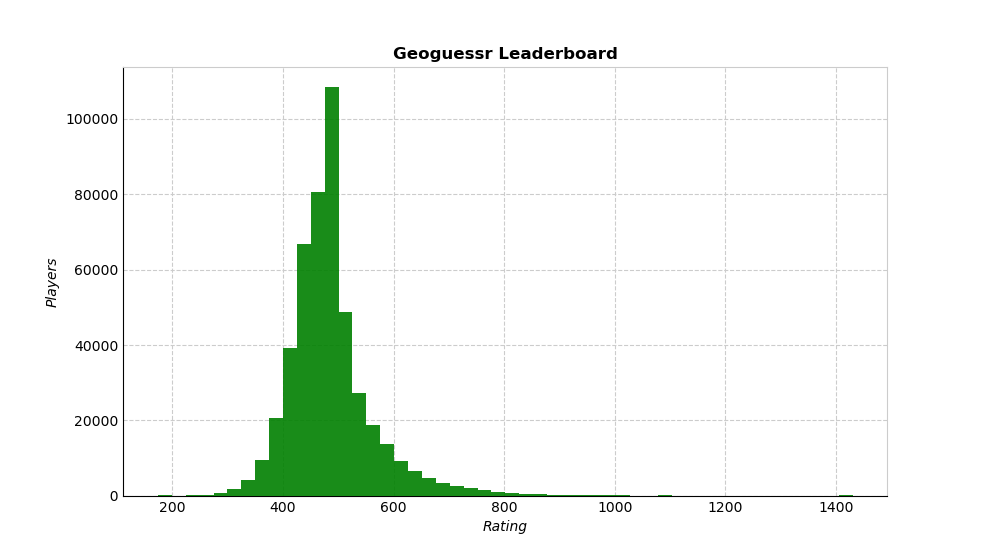
Global leaderboard distribution of ratings as of March 15 2022. (Image source: reddit user MATTISINTHESKY).

Percentiles of GeoGuessr ratings as of March 15 2022. (Image source: reddit user MATTISINTHESKY)
If you play enough Multiplayer GeoGuessr during the week, you should qualify for the weekend series and finally have a good reason to be anti-social on the weekends too. The Multiplayer game mode also currently extends to seasons. I’ve written an explanation below about how to succeed at the three Multiplayer GeoGuessr modes: Battle Royale Countries, Battle Royale Distance and Duels.
Battle Royale Countries

In Battle Royale Countries, you can play versus a motley assortment of GeoGuessr-philes from around the world. Contrary to the name, Battle Royale Countries isn’t a ferocious fight to the death between Prince Harry and Prince William in which the last prince standing inherits the throne (although I would pay money to see this). The GeoGuessr Battle Royale Countries mode entails using your geographic knowledge to identify the country you are placed in. The last player standing is the victor.
There are some tactics to increase your chances of winning. Firstly, be aware that not all countries are included in GeoGuessr. There is a map slightly further down this article in the ‘Fundamental Techniques’ section that depicts the countries included in GeoGuessr. Minus Taiwan, this map largely reflects the countries included in Battle Royale mode.
There are gameplay tactics that you should utilise in Battle Royale. If there are a large number of players left and you are unsure of your location, wait until others have made their guesses. The flags of the incorrect countries guessed will be displayed in the top right corner- you can exclude these countries thus hopefully increasing your chances of victory. Always keep an eye out for these flags- you don’t want to guess a country that has already been excluded. In the first round, there is no hurry to make your guess as all the players will go through if they guess correctly before the stress-inducing timer runs down.
If you can definitively narrow down the location to three or less countries, then there is no point waiting- quickly make the three guesses. For example, if you are certain the location is South Africa, New Zealand or Australia, then quickly guess these places rather than heading off down the road in search of kangaroos. During the early rounds with less experienced players, you can afford to take your time. If you are down to two or three players, it is often worth locking in a guess before the timer commences. I always lock an intuitive guess in before the timer commences when there are 2 or 3 players left. As each round is loading, you can see a blue-coloured version of the next location. Use this time to examine the location and hopefully ascertain subtle clues. Save the 50-50 feature for a location where you are unsure, have used up two incorrect guesses or have explored and are running low on time. Many members in the community frown upon using the 50/50 option when you are down to the last 2 players.

Use the 50/50 feature in Battle Royale after you have had 2 incorrect guesses and are unsure where you are.
When you are down to your last opponent and know the location, it is often worth waiting until the yellow section almost runs out before locking in your guess. This will reduce the chances that your opponent will make a guess solely because you have locked in one early. On any occasion that you lock in your guess before the timer commences, keep moving around rather than waiting to see if you guessed correctly. More advanced Battle Royale techniques to be aware of are listed in the ‘flag trick’ section further down this article.
If you are situated indoors or at a location that isn’t on a road, there is a reasonable chance you are in India. Try to specialise in quickly recognising the quirks of all the Battle Royale relevant countries. Each country has idiosyncrasies that can lead to it being promptly recognised. The bottom section of this article describes what to look for in order to quickly and correctly identify every country in the world.
There are variants of Battle Royale Countries that provide a different time limit, a different number of guesses per round and/or no moving, panning or zooming (NMPZ) restrictions.
Battle Royale Distance

The GeoGuessr developers have gifted us another Battle Royale variant, this one is known as Battle Royale Distance. This version of the game could easily be used in cardiologists’ offices in which patients’ hearts need to be monitored whilst performing a stressful activity. Battle Royale Distance begins with a maximum of ten people who have no idea of the distress that awaits them. Each player must place a pin on the map where they believe the Street View location is situated. From the ten players, the person whose pin is furthest from the actual location after one minute has elapsed is eliminated. This process repeats until there is one person standing who shall be crowned the victor (and also crowned the person with the sturdiest heart).
You begin Battle Royale Distance with a certain number of guesses depending on the variant. For each round you advance, you are gifted an extra guess. Extra guesses are also awarded for being close and guessing the correct country. Like Formula-1 qualifying, once you have placed a guess, you can sit back and watch whether others have made a closer guess and thus whether you need to make further guesses to avoid elimination. You are permitted a maximum of three guesses per round.
Your username will be displayed among the live leaderboard for each round. Above your name will be a number indicating how many kilometres the person positioned ahead of you is closer to the actual location. Beneath your name will be a number showing how many kilometres the person positioned behind you trails you by. These numbers can be useful if you are weighing up whether to make more guesses to ensure that you advance to the next round. Be mindful that if you are only 30km behind the first person in Russia, you likely have made a sufficient guess. If you are 30km behind the first person in Andorra, you have likely made a poor guess (and you may also be a liar as Andorra’s width is less than 30km).
Before making your second, third, fourth guesses, be aware of where you are on the leaderboard and the gap between you and the person above you. If your subsequent guesses reduce your gap, it is a clue as to which direction your future guesses should be in. If you subsequent guesses don’t reduce the gap then avoid that direction and opt for guesses in a different direction.
Try to avoid waiting until the last 10 seconds to make your first guess. If your first guess happens to be inaccurate, you will have little time left to make another guess. I like to look around for the first half of the time limit (especially in urban rounds or areas that may provide directional signs) then make a guess. I then try and determine whether I need to make a subsequent guess and where this guess would be, depending on my confidence in the location and where I am ranked. Throughout each round you should always be considering where you will make another guess if need be. At present, there seems to be a disproportionate number of capital cities being represented in Battle Royale Distance. For example, if you are in a city in Ukraine, it may be worth guessing Kiev.
Tactically speaking, the only aspect to focus on in Distance Battle is not being last (although I generally recommend guessing if you are second last and in many instances third last). Once you are down to the last few players, you can use up your stash of saved guesses to a maximum of three per round. In the latter rounds, if you are certain that you are in a specific country and have few other clues to go on, it may be wise to disperse your guesses around the country, whilst looking at the leaderboard to see if you are getting closer or further away hence tailoring your future guesses. Only your closest guess will count. This is akin to dating lots of people at the same time and hoping that one is a reasonable human being (and interested in GeoGuessr).
If you only have one saved guesses in the very last round versus an opponent who has three guesses, it may be worth waiting until the last 15 seconds (or less) to use your guess. If you use it early, your opponent’s distance to you will be displayed enabling them to gauge whether their future guesses are getting closer to the actual location.
There are variants of Battle Royale Distance in which you start with a different number of guesses, have a different time limit per round and/or no moving, panning or zooming (NMPZ) restrictions.
Duels

If you think it’s impossible for a wholesome game of geography to descend into a game in which you try to destroy your opponent- then you are wrong. Welcome to ‘Duels’. In the Duels game mode you compete against one opponent with the aim of vanquishing them with your GeoGuessr knowledge.
You and your opponent will each begin a Duels game with 6,000 life points. After each round, the difference between you and your opponents scores for that round (according to traditional GeoGuessr scoring) will be tallied. This value will be deducted from the loser’s life points. The first player to lose all of their life points will be declared the loser of the duel. In round 5 the loser will be deducted 1.5 as many life points. This increases incrementally by 0.5 each subsequent round to x2, x2.5, x3 etc.
Some further Duels notes: As soon as the first player makes a guess, the countdown clock will begin and the other player will be required to make their guess within 15 seconds. You are also only permitted to make one guess per round.
In terms of tactics for ‘Duels’, it is often a good idea to guess quickly if you notice an identifying feature of a country- for example Polish bollards. This will prevent your opponent from moving around too much to determine the country.
If your opponent guesses first, place a pin down but never press guess. Utilise the extra 15 seconds looking for further clues. The system will automatically lock in your guess where your pin is once the 15 seconds have elapsed.
If you notice a sign down the road or other clue in the distance that may provide a city/region name or clue, don’t guess quickly but rather travel to the sign. If you guess quickly in this scenario and the sign is less than 15 seconds away, you are allowing your opponent to see it but depriving yourself of this experience.
It’s not typically worth spending time pinpointing 5,000 point rounds in Duels. Most of the time, once you work out your general location, guess as quickly as possible and put the pressure on your opponent.
Party

If you click on ‘Party’ you can play the various GeoGuessr modes described above with friends (or enemies that you wish to crush with your GeoGuessr prowess). In addition to the game modes already mentioned, you can also play ‘Bulls Eye’ which is a co-op mode: words not in my vocabulary. You must work together (more words not in my vocabulary) to narrow down the location. Place circles over a region with the smaller circles earning more points, if accurate.
Quiz

The GeoGuessr boffins have managed to squeeze another game mode out of the GeoGuessr concept. Welcome to ‘Quiz’. In Quiz mode you will race against the clock to answer quiz questions. Typically, the faster you answer, the more points you will earn. Some questions will require you to select countries on a map whilst other modes will have you playing GeoGuessr and working out where in Street View you are placed.
GeoGuessr Pro
From the dawn of time to August 2019, GeoGuessr was a free game with almost all the features (besides to ability to make maps) available to the masses. GeoGuessr are required to pay Google a small fee each time a player uses Street View or Google Maps. Google recently increased this ‘small’ fee by 1400% and this has forced GeoGuessr to make some changes. Personally I’m boycotting Google and will be reverting to search engine Alta Vista…. Okay, I’m reliably informed by that Alta Vista no longer exists.
The post August 2019 version of GeoGuessr requires players to become ‘Pro’ users to utilise the range of features and this costs US$1.99-$2.99 a month. Using the Pro service you can make maps and play all maps to your heart’s content.
For those unable or unwilling to pay this Pro fee, GeoGuessr can still be played by creating a free account. With a free account, challenges on all maps can be freely played to your hearts content. Click ‘join challenge’ on any of the hundreds of challenges on the GeoChallenges subreddit and presto, you can continue to play for free to your heart’s content.
Personally I believe the right to play GeoGuessr is a basic human liberty akin to having water, food and shelter. *Insert a rant involving something to do with the Geneva Convention*. Hopefully GeoGuessr will last for a long time into the future, surviving any impending nuclear war, outliving the cockroaches and even the Kardashians.
Fundamental Techniques
- GeoGuessr Coverage
- Prevalence of Location
- Poor Picture Quality
- The Sun
- Left vs Right Driving
- Roads
- License Plate Basics
- Tactics
- How To Move Fast
- YouTubers
GeoGuessr Coverage
By now you have listened to far too much of my ramblings that are perhaps more suited to graffiti on a toilet wall. I will finally start detailing the techniques required to be victorious in GeoGuessr.
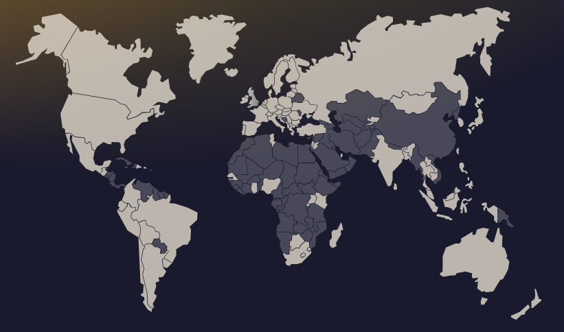
There are large pockets of the world that aren’t covered by Street View and thus being cognizant of these locales will improve your GeoGuessr game. The map below indicates what countries are covered by Street View and thus likely GeoGuessr. There are some caveats to the below map. Firstly, I have never seen a street in Antarctica on the game and in fact I was unaware that Antarctica was a thriving metropolis that has frequent traffic jams. Some countries including China appear in the game but only as landmarks and the streets aren’t fully navigable thus you should be able to determine that you are in these countries. Other places such as India occasionally pop up but typically you can’t traverse far either in these areas. For a detailed explanation of which places Street View covers and to what extent, see the link here. If you are an even more hard-core GeoGuessr player, then this linked map showing GeoGuessr location based on a certain number of game simulations may be pleasing to your eyeballs. A lower section of this article features maps showing more specific coverage within each continent.
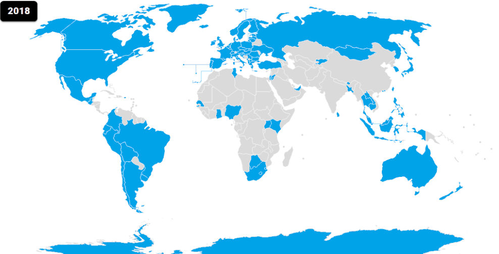
A map showing the locations covered by Street View in 2018 and thus GeoGuessr. The blue countries are possible locations in GeoGuessr. (Source: Eugen Simion 14, Wikipedia). A larger map can be viewed here.
Prevalence of Location
Whilst playing the GeoGuessr world map, it is important to be aware of the distribution of countries. If you perpetually select Eswatini, whilst neglecting the rarity of Eswatini appearing, then you will score poorly. Russia, the USA, Brazil, Argentina, Australia, Norway and the rest of Europe account for a significant portion of GeoGuessr locations. This is crucial information. Learning the idiosyncrasies of these countries is imperative. Also, when tossing up between countries, skew your guess to one of these aforementioned areas.
For all of the glory of GeoGuessr and its founder Anton Wallén (all hail Mr. Wallén), the disproportionate nature of countries appearing can make some rounds rather repetitive (I now have a useless knowledge of obscure Russian roads taking up space in my brain). There are egalitarian GeoGuessr maps that can be fun to play that contain a more equal distribution of countries, less poor quality locations and typically hand-picked places. Think of these maps as the communism of GeoGuessr, if that communism is a computer game involving geography largely outside of communist countries.
- A Community World map can be played here.
- The Balanced World map can be played here.
- The Improved World map can be played here.
- A Pinpointable World map can be played here.
- The AI Generated map (providing further evidence that computers are plotting to take over the world) can be played here.
If trying to distinguish between different shades of grass and different bitumen road laying techniques isn’t your thing whilst playing GeoGuessr’s largely rural maps, then perhaps strictly urban maps will be more to your liking. You will get to decipher clues within only cities; from written languages, cars, people and cultures to muggings.
- The Urbanguessr map can be played here.
- The Famous Places map (which also features some famous rural areas) can be played here.
Poor Picture Quality
Have you ever played GeoGuessr and then a place pops up causing you to make an appointment with an optometrist? Intermittently you will come across a location on GeoGuessr with image quality that looks like it has been photographed by a Nokia 3315 phone. This is doubly remarkable for this phone considering it didn’t have a camera. As annoying as these locations are (they typically don’t exist on the maps listed above) they do provide some insights other than being somewhere that employs blurry sign writers. The blurry locations in GeoGuessr are almost certainly in the USA or Australia. Further information can also be deduced from these places. They will likely be a more remote region; often in the central corridor of the USA and not a large city. In Australia, the blurry locations are normally outback areas and away from the major cities (this still includes most of Australia). Why the economically deprived country of Botswana has crystal clear images whilst the filthy rich countries of Australia and USA have blurred photos is largely due to the outdated cameras used on the Street View car in the USA and Australia from several years ago. Also, horror movies portray these areas as dangerous and no-one from Google will sign up to drive through these regions for Street View; a movie idea- A Street View driver captures their own death on Halloween as they are killed by monsters. Trademark.

Poor picture quality locations in GeoGuessr indicate that you are in the US or Australia. They don’t indicate that you need to make an appointment with an optometrist.
The Sun
The sun isn’t just useful for helping sustain life on earth but is also one of the key instruments in GeoGuessr. Which of these traits is more useful is debatable. In Street View, if the sun is clearly in the Northern Hemisphere then you are probably in the Southern Hemisphere and vice versa. There is a compass in the corner of the GeoGuessr game that always orientates you north at the start of every round. The red end of the compass indicates north and rotating your computer around won’t move this compass. My first process when playing GeoGuessr is to determine which hemisphere I am in. The easiest way to do this is by looking at the shadows. If the tip of a shadow is pointing south then you are likely in the Southern Hemisphere and if a shadow tip points north then you are probably in the Northern Hemisphere.

The red compass point always points north. In this example, we are facing west.

Note the direction of the compass (the red end being north) and the shadows’ tips also pointing north. The direction that the shadow’s tip points generally indicates what hemisphere we are in- in this case the Northern Hemisphere.
If the shadows are unclear then panning up to the sky to find where in the sky the sun is can be useful. Often the sun is shrouded in clouds however a bright patch of sky can be observed (make sure the sun is in the centre of your screen for accuracy). If the sun is in the Northern Hemisphere then you are in the Southern Hemisphere and vice versa. In some scenes, the sun and shadows are obscured but part of a rolling hill or building is illuminated and you can thus determine where the sun likely is. This sun-hemisphere determination process akin to some ancient civilisation’s infatuated worshipping of the sun, can be problematic. The closer the sun is to the northern or southern horizon, the more accurate guide it is. On some occasions the sun will appear overhead and you will then possibly be between the Tropic of Capricorn and Tropic of Cancer. There are few guarantees with the sun due to the variance in season that the Street View location was photographed.

In this example, we are facing north (as indicated by the red compass). The sun is therefore in the northern hemisphere, making our location the southern hemisphere.
Another technique I use if the sun is obscured is to exploit society’s addiction to TV and search for visible satellite dishes. These almost universally point towards a satellite orbiting above the equator in geostationary orbit. If a satellite dish points south then you are likely in the Northern Hemisphere and vice versa. A satellite dish pointing directly upwards means you may be near the equator. On occasions I have played a timed round and stumbled across a satellite dish in Brazil and its angle has helped me determine an approximate latitude. I for one stand against streaming services such as Netflix due to their potential destruction of TV satellite dishes potentially jeopardising future usage of satellite dishes for GeoGuessr rounds.

Notice the dish facing south at quite an extreme angle (almost perpendicular to the ground). This indicates that we are in the Northern Hemisphere and probably relatively far north.
Left vs Right Driving
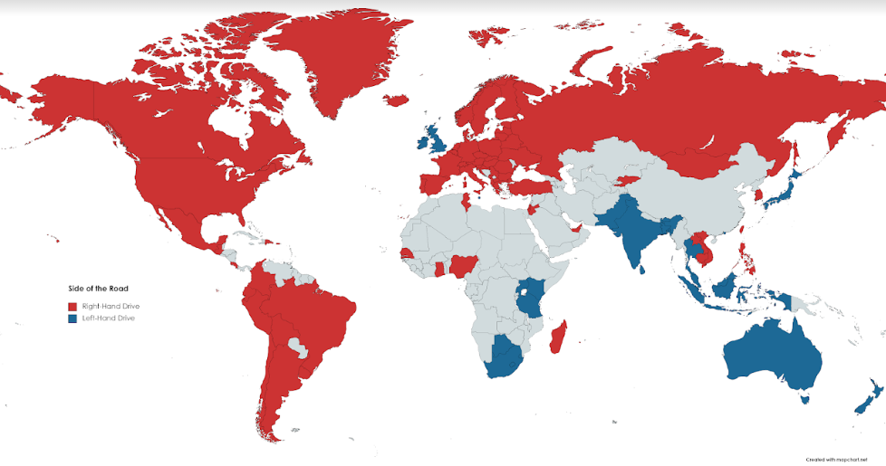
The red countries drive on the right side of the road and the blue countries drive on the left side of the road. The grey countries aren’t in GeoGuessr. (Image source: Avery Johnson).
Another key clue to pinpoint the country you are placed in within GeoGuessr is to note the side of the road that vehicles are driving on. This of course ignores drunk drivers, hoons and those overtaking the chug-chug steady paced Google Street View car. As a general rule, countries of British origin (not Canada) drive on the left hand side of the road as well as island countries (not the Philippines or Iceland). Most other countries drive on the right-hand side of the road. Finding a left-hand side of the road car in GeoGuessr is akin to finding a dragon’s egg, wrapped in unicorn hair in the possession of a justifiably famous Kardashian.

Noting the side of the road that the cars are driving on/parked on can be useful in GeoGuessr. In this example, the car is driving on the left, which significantly narrows down the country.
Within the restricted versions of GeoGuessr and in some remote locations, cars aren’t visible (they aren’t invisible, there are just no cars around). In these instances other clues must often be attained to determine what side of the road the drivers are using. A fairly accurate indicator is to look for signposts. They tend to lie on the side of the road that drivers drive on. For instance a ‘warning Lannister army approaching’ sign situated by the right hand side of the road (from your perspective) will likely mean that drivers in that country or fictional HBO world drive on the right side of the road.

Although there are no cars visible, we can see a sign facing drivers who drive on the left. This suggests that we are in a country that drives on the left.
In some areas, an antenna is visible on the back of the Street View car (behind the camera). Also, on many rounds, if you look down, the side mirrors of the car are visible by shadow. These are in front of the Street View camera. By using either of these entities, you can determine if the Street View car is driving on the left or right of the street.

If you look carefully on this occasion you will see a floating antenna. This is mainly found on the back of the Street View car. In this instance we can determine that people drive on the right in this country.
If the road is one way, you suspect a drunk driver is not obeying the country appropriate side-of-road driving law or cars are parked facing both directions then a handy tip is to look for what side of the car the steering wheel is situated; a left side of car steering wheel (from the driver’s perspective) indicates a right side of the road driving country and vice versa.

In almost all locations, right side of the car steering wheels= a left side driving country and left side of the car steering wheels= a right side driving country. In this image, the steering wheels are on the left (from the driver’s perspective) thus the cars drive on the right side of the road.
Roads
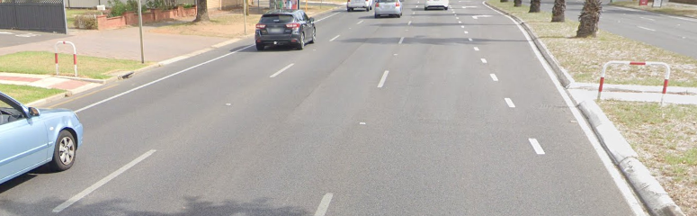
To most muggles, roads are made from asphalt and concrete. Enter the magical world of GeoGuessr where so much more information can be gained from glancing at the road. Line markings are particularly useful in determining what region you are in. Yellow centre lines are prevalent from the top of North America to the base of South America (an exception is that most of Chile has white lines). The odds are if you see a yellow centre line you are somewhere on the American continents. A faded yellow middle line normally indicates Mexico or a country south of this. South Africa also has the occasional yellow centre line as does Japan. White centre lines are more predominant throughout Europe and Australia.
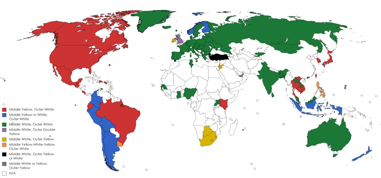
This map shows the most common road lines used in each GeoGuessr relevant country in the world. A larger version of this map can be found here. I don’t know who created this map but thank you whoever you are- it is one of the most important maps for GeoGuessr players.

Most of North and South America have some iteration of yellow centre lines.

Most European and Australian roads have some form of white centre lines.
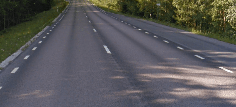
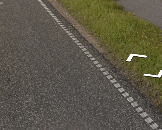
Dashed white lines on the edges of roads are quite common in the countries of Denmark, Norway, Iceland and Sweden. Norway tends to have yellow centre lines and Sweden tends to have white centre lines. Finland often has centre yellow lines and centre white dashed lines; it doesn’t have dashed lines on the edges of its roads. Russia has a road line that is thinner than other country’s road lines. There are of course exceptions to these rules. One such exception is that parts of France occasionally pop up with dashed white street lines. Another exception is the Dutch islands south-west of Rotterdam that are connected to the Netherlands via road bridges. This area mainly has dashed white lines on the sides of their roads.

Dashed white lines on both sides of the road are most commonly found in Sweden, Norway and Iceland.

Norway also commonly has yellow centre lines and white side lines.
Sweden commonly has the aforementioned white dashed side lines and a white centre line.
Many main roads in Denmark have this distinct short-dashed edge marking.
The four countries of South Africa, Botswana, Eswatini and Lesotho tend to have simultaneous yellow edge road lines and white road centre lines for their major roads.

Yellow side lines and white centre lines are a common sight in South Africa, Botswana, Eswatini and Lesotho.
The condition the road is in tells us information about the type of country we find ourselves. The richer a country, the better maintained their roads are on average. Russian’s lengthy road network can sometimes be easy to detect due to the crumbling roads. Another road quirk I’ve noticed involves the typical width of roads in certain regions. European roads tend to be fairly narrow, contrasting the wide roads of the USA and Canada. Although roads in Turkey are often wide with many lanes.
Smooth and well-maintained roads are typically found in Western Europe, USA, Canada, Australia, New Zealand, Japan, Singapore and Taiwan as well as other richer nations. If you see a road that has many cracks, faded road lines or has been poorly maintained, you are likely in Eastern Europe, Asia or Africa.
License Plate Basics
License plates are typically blurred in Street View due to something called privacy. At least there is some privacy left in the world and we don’t live in a dystopian future in which society has crumbled and the major companies and governments of the world are able to track everyone all the time via a magical tracking device that everyone carries around with them in their pocket. UPDATE: I’m reliably informed this has already occurred.
License plates are useful in GeoGuessr for three reasons. Firstly, some locations have coloured license plates ie yellow that will make it easier for you to guess the location. Secondly, certain countries and areas have short license plates whilst other places have long license plates. Finally, some locations won’t have front licence plates. There is a detailed license plate section in the ‘General clues’ section of this article that provides all of the important license plates to learn. Some basic ones are covered here.

License plates in Europe are generally long and skinny. They also typically have a blue section on the left of the plate. Long and skinny license plates are rarely found outside of Europe.

License plates in some other western countries outside Europe, such as the USA, Canada, New Zealand and Australia are typically short.

In Europe, yellow license plates are mainly found in the Netherlands and Luxembourg. In Asia, yellow plates are mainly found in Japan and Israel. In South America, yellow plates are found in Colombia. The UK, Sri Lanka, Botswana, Rwanda, Kenya and Uganda are the main locations with yellow rear plates but white front plates.

If you notice a car without a front license plate, you are most likely in the south-eastern US or perhaps a state stretching up to Michigan or a southern state stretching across to Arizona.
Tactics
Whether you are trying to win a game of chess, attempting to rig a FIFA World Cup vote or trying to score highly in GeoGuessr, tactics are required. When the location loads it is often a good idea to initially analyse your surroundings and rotate around 360 degrees. On occasions, a player who races off down the street will miss a sign behind their back or some other clue. This patience and rotation is also useful in timed games and the various GeoGuessr modes. *Insert more updated tortoise and hare reference*.
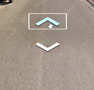
Firstly I will mention some basic gameplay tactics. To move one step at a time, click on one of the two white arrows that appear below you (more arrows will appear at junctions).
There is a quicker way to move in GeoGuessr- The location on the road you place your computer’s cursor will show up with a circle containing an arrow akin to a symbol resembling some superheroes logo (GeoGuessr Man- He doesn’t save lives but improves people’s esoteric geographical knowledge slightly). As you hover this logo further down the road, the circle will become narrower. As soon as you click, you will be transported to this location. If the superhero logo becomes a parallelogram in shape and you click, you won’t be able to move forward to your desired location, instead you will probably move forward just the one space. To move a great distance, place the circular superhero logo as far down the road as you are permitted, making sure it doesn’t transform into the parallelogram and then click.
On the left of this image is the circle containing an arrow. Placing this as far down the road as possible whilst it retains its circular shape is the key to moving quickly. On the right appear two white arrows that will move you one step at a time.
The flag icon on the left of screen takes you back to the start point and is useful for attaining a perfect score once you have moved around and worked out your general location. When you do move, remember the path you have taken and direction you have moved in; this will come in useful when retracing your path or if you find a familiar sign.
Clicking on the flag icon will take you back to your starting point.
The below icon indicates a checkpoint. You can use this function to essentially save a location that you may wish to return to instantaneously later. I tend to utilise the checkpoint in three main scenarios. Firstly, if I am on a remote road and have moved in one direction for a significant time, I will set a checkpoint before clicking the flag icon, returning to the start and moving down the road in the opposite direction. In this instance, I may find the opposite direction has a dead end or it may be even more remote (cue Australia) thus I return to the checkpoint and continue on my original way. The second scenario involves setting a checkpoint at a minor road number sign or at a sign with smaller town names. I will then explore further, work out the vague area I am situated, return to the checkpoint and use the sign to work out more accurately where I am located. The third scenario I will use a checkpoint is if I reach a junction and am unsure which way to go (an apt metaphor for life, which unfortunately doesn’t dispense checkpoint saves).

This icon indicates a checkpoint. You can click on it to save a location which you will be able to return to when you wish.
The image below is the undo icon. If you click on it you will undo your last move. It is most useful if you find yourself quite contently travelling along a highway before you randomly appear on a side street that you don’t know how you arrived on. You can click the undo icon multiple times to undo multiple moves- something I wish I could use for my life’s choices.

This is the undo icon that will undo your last travel move in GeoGuessr.
If you are the type of person who listens to podcasts on quantum mechanics at 4x speed then you can probably skip this paragraph. There are some GeoGuessr keyboard short cuts to shave seconds off your game play time. In case you are using a laptop, press + and – to zoom in and out of Street View. The left and right arrows are used predictably to pan left and right. Previously in GeoGuessr I was acting like an elderly person who crosses the road absentmindedly then gets honked at by an obstructed car and then takes a prolonged time to turn around to examine said car by which time said car has long passed. The left and right arrows have changed this. The up and down arrows are useful in moving back and forward in case you have just narrowly passed a sign and want to go back and look at it. Double clicking on the map will zoom in to that location faster than the conventional zoom buttons on the map.
Using a mouse makes GeoGuessr gameplay much easier and efficient. The mouse wheel of the non-rodent variety can be used to zoom in quickly on Street View signs as well as the map. Playing on a laptop touchpad is disadvantageous and akin to not having one of those secret motors some cyclists use in races. If you aren’t sure what specific buttons to press with your setup then I recommend pressing random buttons and observing what happens, much like how this article has been written.
You don’t need to click the green ‘guess’ button, which can double as advertising for the clothing company, to lock in your guess. If you click on the spacebar, you will lock in your guess. This spacebar technique is faster and particularly useful in quick rounds.
When decided on the direction to travel, heading towards nearby signs, houses, shops, major roads, towns and around corners can be useful. When faced with a dilemma as to which way to travel, think of yourself as a lazy, hitchhiking busker- they will want to travel downhill, towards a town and preferably onto a main road. The downhill aspect of travelling is important as interesting things seem to lie at the bottom of hills such as towns, rivers, bridges and key roads. There are the occasional exceptions. Sometimes you will be stuck in a town or city and unable to work out where you are. In these instances, it can be beneficial to exit the town/city to find its name or other useful signs.
If you see the name of a towns on a sign, eg XYZ 6 km away and ABC 56 km away then generally search the map for the town further away (or preferably both towns) as the further away town is likely to be bigger and easier to spot on a map. Depending on how far you have narrowed down your region, it can be sensible to even search for tiny towns on the map. This is often contingent on the region’s size. For instance, if I notice a Dutch town name, I know the Netherlands is small and I can zoom quite far in on the map and look for towns matching the name I have found. Contrastingly, this won’t work well in vast Russia.

If you encounter a sign with the name of multiple locations you don’t recognise, search the map for the location that is furthest away as it is likely to be larger hence easier to find on the map. In this example, we would search for Rosario.
When I am uncertain on a country whilst playing a timed version of GeoGuessr, I brainstorm a handful of countries that I think might match where I am and try and work through each of them- looking at how well they fit the environment around me.
The zoom feature in the form of the plus sign in the GeoGuessr Street View format is one of the most useful tools in the game. It turns what are optometry tests in the form of signs that are illegible into slightly easier optometry tests. Zooming in to view any writing anywhere in Street View is key to working out clues to tessellate together.
Zooming into the map can make more information appear. For instance, you often need to zoom in a specific amount to see the name of states. The below image shows a dotted border, indicating a state border. Zooming in to the correct level will reveal street names, house shapes and if you zoom in the maximum amount and then use an electron microscope, you may be able to just make out my integrity.

Zooming into the map makes more things appear like these Peruvian state names.
If you are not quite sure on the precise location and want to click somewhere, try and match the road direction you are on to one going the same way on the map. You can always determine the road direction by using the compass. Cue my defacing of a perfectly good photo.

In the top image, I’m facing north (as determined by the red compass). The red, diagonal arrow in the top image shows the direction of the road (north-east to south-west). I can then match the direction of the road onto the map to look for suitable roads facing in the same direction.
The most accurate way to determine the true direction of the road is to pan down completely and face north.
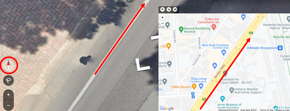
If you wish to determine the exact direction that the road is facing, which is often a useful process in GeoGuessr, then pan so you are looking straight down. Make sure you are facing north and the road beneath you will be running in its true direction.
If you are keen for a perfect score and have narrowed down the street, try counting houses to get to your precise start location and match this with houses visible on the map. If no houses are around, try and survey your surroundings and match up a bend in the road with where you are or some other feature.
The dark gray rectangles on the zoomed in map represent structures such as houses. It can be useful to match these to your Street View surroundings if you are after a perfect score.
When travelling, make a map in your head of the general path you are moving from the starting point. When you start a round, take note of any distinguishing features of your starting location: this may include rivers, lakes, bridges, railway tracks, specific shop names etc. doing both of these things will come in useful if you have to pinpoint in a timed round. For instance, you may work out the town you are in or near and now know what direction you travelled to get to the town. If you started on a bridge, you can probably pinpoint rather easily unless you are in Venice.
After you have made your guess and found out how far you are from the real location, take some time to zoom in to the actual location so you can learn what the real place looks like on the map. Also, try and see if you missed any clues near the real location such as towns or geography that you can learn from. Essentially, try and learn from your mistakes every round.
If you are after a perfect score and are trying to pinpoint the final place on a flat stretch of road with no markers, one technique is to count the number of forward clicks required to move to the nearest notable feature eg a bend in the road. Do this for both directions then work out the ratio you are away from each feature in order to make an accurate guess.
Always remember to drop a pin down in time games. It is easy to be so engrossed in a game of GeoGuessr that time seems to fly by (the opposite of what happens during school). As soon as I have a general idea of the area, I zoom in and place a ‘safety pin’ down before I try and narrow down the region further. By developing this habit you won’t have to worry about getting zero points thanks to being timed out.
It can often be challenging to determine where in a country you should place your pin. If I see French bollards and houses that look slightly Belgian, I will place the pin somewhere in France near the Belgium border. By looking at many types of clues and balancing them, you should begin to develop an idea of where in a country to place pins. Use this technique whilst looking at the colours on the map corresponding to certain landscapes. Also use the general weather as a guide i.e. if you see a blue sky in Japan, you are probably in southern Japan, closer to the equator as opposed to the cold northern Japan.

When weighing up where in a country to place the pin, examine how similar the region you are located in is to nearby countries. In the above image, there are vertical yellow and black stripes on the utility pole which are Japanese. The landscape looks more Taiwanese therefore we can deduce that we are on the southern Japanese island of Okinawa, near Taiwan.
Scoring well in the 3 minute Daily Challenge involves several techniques (this version passes in about 10 seconds for me due to my slow Australian internet. It seems that everything on the screen goes slowly for me….besides the countdown clock). Firstly, the key is to have fast internet. Secondly, travel at the speed of an F1 driver (who isn’t driving on wet roads) searching for a city sign or highway sign. Whilst travelling, try to pick up clues as to what country you are in. Try and recall the route you have taken in order to quickly pinpoint if you later spot a useful sign. I’ve linked to several GeoGuessr experts’ YouTube videos at the end of this section and watching them play the Daily Challenge is a good guide to the best techniques in GeoGuessr.
The most sure-fire way to improve at GeoGuessr is like most other things (skydiving not included) by failure. By making mistakes and learning, your game will consistently improve. Also, don’t compare yourself to people getting 25,000 point perfect scores in 10 second world rounds. Some of these people cheat. There is a way to cheat in GeoGuessr that I won’t describe here that gives you the co-ordinates for the location and these high scorers cheat. They are the athletics dopers of the GeoGuessr world. Having said that, there are some genuine GeoGuessr geniuses (or is it spelt genuses?) out there. These supernatural beings with eidetic memories are capable of identifying familiar patches of road; I’m looking at you Boky (the Tony Hawk of GeoGuessr). These rare humans are capable of a genuine 25k score in quick rounds.
How To Move Fast
If you want to move quickly in GeoGuessr, press enter while holding down on an arrow using your cursor. If you release your cursor but continue to hold down enter, you will move at lightning speed down the road.
Personally, I enjoy aimlessly clicking for hours on end while traversing a remote Mongolian road. However, if you for whatever reason don’t like moving slowly in GeoGuessr, there is a solution.
Click on one of the large directional arrows that appear in GeoGuessr. While pressing down on the arrow, hold down either enter or spacebar (I recommend pressing enter, as spacebar can inadvertently send your guess). A rectangular box will appear around the arrow (as pictured above). You can now let go of your mouse—you need to continue to press enter—and you will move quickly down the street.
This is how GeoGuessr pros move. This is the best way to move in GeoGuessr, especially when you are stranded in a rural location that will take hours to escape. While using this technique, be wary not to pass any useful signs. Also, I would be cautious about using this technique in urban areas. In certain circumstances I recommend it; however, I wouldn’t always use when there is lots of useful information around.
YouTubers
Practicing GeoGuessr and familiarising yourself with what different regions and countries look like is key to the game. Another excellent way to improve your game is to watch YouTube videos of GeoGuessr experts playing. For light hearted fun I recommend watching GeoGuessr Wizard’s YouTube channel, found here.
To improve your GeoGuessr game, I recommend those channels that show players getting perfect 25k scores or close in the Daily Challenge. Other useful videos include those attaining ridiculously long country streaks.
- Zi8gzag’s channel is here.
- BarrBarrBinks’ channel is here.
- Jake Lyons channel is here.
- GeoPeter can be found here.
- Chicago Geographer can be found here on YouTube.
- Geography Challenges GeoGuessr videos can be viewed here.
- Rainbolt and his tournament videos can be seen here.
- RC’s channel is here.
- Simi’s YouTube is here.
- SubSymmetry’s YouTube videos are here.
- RadoX1988 has his channel here.
- The GeoGuessr Esports videos are here.
The GeoGuessr subreddit has many challenges in which you can compare yourself to the best players in the world.
Highway Numbering Systems
- USA Highways
- Canadian Highways
- Mexican Highways
- Brazilian Highways
- European E-Roads
- General European Road Numbering Signs
- Russian Federal Highways
- Great Britain Highways
- Spanish Roads
- Norwegian Roads
- Swedish Roads
- Finnish Roads
- Japanese Highways
- Warning Signs
Any serious GeoGuessr player will get slightly aroused when they encounter a road sign. These are perhaps the most important clues within the entire GeoGuessr game. Those teenagers that have a stolen a ‘Booger Hollow Rd’ sign and hung it up in their bedroom should be themselves hanged by the country on account of depriving GeoGuessrs’ their rightful signpost clues.
Location Names
The crème de la crème of signs in this game are place names. Often a larger city with a direction sign will help narrow down your region. Local street names or highway numbers may further tighten your search. Even if a location name isn’t known by you, if it is large enough population-wise, you may be able to find it whilst searching on the map. The street names and locations on signs should help you to at least determine the country or region you are in. I will elaborate on languages in a subsequent section.
Often you will encounter signs with a place name followed by a number e.g. New York 42. This indicates the distance until you reach the place. In this instance you are 42 miles away from New York. (Be mindful of the kilometres vs miles differentiation depending on the country). Using the compass in a situation that you encounter a sign like New York 42 is vital. You can determine the general direction the road is travelling using the compass (don’t rotate and then drop your computer) and then work out approximately which road approaching New York you are on and estimate about 42 miles along this road.
Highway Number Signs
Most countries on Street View tend to have some form of highway numbering system. If you are in Japan and see a highway 112 sign, then by zooming in on the map you will see Japan’s numbered highway network. Sometimes it takes some time to pinpoint the precise highway on the map but persistence is key. Actually scrap that- intelligence is key. Maybe ingenuity is key. Let’s say decisiveness is key. Try and determine the pattern of the country’s highway system you are searching. If you are looking for highway 112, then finding highways number 110-120 might lead to the adjacent or intersecting highway 112. I will detail some specific (and Pacific) highway numbering systems in this section.
As a handful of countries make up most of the GeoGuessr locations, it’s important to be familiar with their highway signs and how to pinpoint these numbers on the map.
USA Highways
Warning: prepare to be bored.
USA County Highways: As an alien to the USA, the highway system took me some deciphering akin to Egyptian hieroglyphics. Apparently there is something logical to this system. Firstly, the smallest highways that are numbered in the USA are county highways. County Highway signs typically have the word “county” on them as seen below. These highway signs appear on the map as bland rectangular shapes also as seen below. County highways are largely useless unless you recognise the name of the county. The amount of zooming in required on the map makes county highways often useless to GeoGuessr players without further information.

The symbol for US County Highways as it appears on the map.
An example of a US County Highway sign

Another example of a US County Highway sign
Texas Farm Roads: These are essentially the Texas equivalent of County Highways. They provide more useful information than standard county highways as they tell you explicitly that you are in Texas with flashing lights (really just the word printed as ‘Texas’). A typical Texas farm road sign appears below. Each Texas road has a unique number (sometimes with a letter) making them useful for zooming in on the map and detecting. They appear on the GeoGuessr map as bland rectangular shaped signs. You need to zoom in quite significantly on the map to see these signs.
A Texas Farm Road as it appears on the map (the same symbol as US County Highways)

A sign indicating a US Texas Farm Road
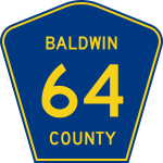
State Highways: These types of highways traverse a solitary state (not liquid, gas or solid). Virtually each state has its own unique state highway sign with a few exceptions: Iowa, Mississippi, Delaware and New Jersey (the cultured area that gifted the world the TV show Jersey Shore). These four states share the same state highway sign that is essentially a black background enclosing a white circle. Also the proximate states of Maine and Massachusetts have signs that I can’t distinguish between featuring a white square with a thin black border. On the GeoGuessr map, the state highway numbers appear as quasi round white shapes. In order to notice the state highways on the map, you will be required to do some zooming but not quite as much as the aforementioned County Highways. State Highway shields are useful to spot in GeoGuessr as they narrow down your map search to a single state. If you see a state highway sign that you don’t recognise, it may be the outline of a state which you can determine by matching it up with the map.

State Highways in the USA appear with this symbol on the map.

A map showing the specific State Highway shield for each USA state. Note that in 2016, North Dakota’s state highway sign switched to an outline of their state with the words ‘North Dakota’ above it. (Source: Mdcastle, reddit)
United States Highways: These highways cross more than one state and the signs appear as a white shield with a black number and black outline to the shield. These highways appear on the map as the same design as the signs. US Highways appear on the map as yellow roads. There is a numbering system to US Highways (hallelujah!) that enables you to not waste time (let me change that to ‘more time’ as according to muggles playing GeoGuessr wastes time). Odd numbered US highways typically run in the general direction north-south. Contrastingly, even numbered US highways normally run in an approximate east-west direction. If you spot a US highways sign numbered ‘40’ you immediately know that it runs across at least a couple of US states in an east-west general direction.

The symbol denoting United States Highways on the map

The United States Highway Shield
US Highways are numbered with 1, 2 or 3 digits. Highways numbered with 1 or 2 digits eg 7 or 49 are major US Highways. Routes numbered with 3 digits eg 160 are spur roads. These spur roads veer off from their parent road inheriting their 2nd and third digits from their parent road. US highway 160 spurs off from US highway 60 in Missouri. US 260 spurs off from US 60 in Oklahoma, US 360 veers off from US 60 in Texas and US 460 and US 560 spur off from US 60 in New Mexico.
There is a numbering system to US highways amongst all this craziness. Odd numbered US highways increase in number from east-west. Remember that odd numbered US highways are north-south running. Given this information, US highway 1 is north-south running and hugging the east coast. Contrastingly, US highway 97 runs through the western states north-south.
Even numbered US highways tend to increase in number from north to south. Remember that even numbered highways run east-west. Given this information, US highway 2 snakes just below the Canadian border and runs east-west. US highway 98 runs east-west through the southern states of Alabama and Florida.
If I haven’t bored you by running through the US highway numbering system, I will try and provide a technique to remember this information. I remember the fact that US highways that are even run east west by thinking of the Canadian-US border and thinking that the line is very even. Everything parallel with this line is also even. I remember that US highway that are odd run north south by thinking of the rugged coastline of the US as being uneven or ‘odd’. I remember the method of the increasing number that the US highways follow by thinking of the state of Maine which is in the north east corner of the US. This is the corner where the lowest number for both east-west and north-south highways originate. Every highway west of Maine increases in number and every highway south of Maine increases in number.
USA Interstates: Congratulations if you managed to read through the last section. Now onto the El Chapo of US roads- interstates. These freeways run across the country. Signs are conspicuously blue and red and explicitly and creatively state ‘Interstate’. On the map they appear identically as blue and red shields and can be viewed fairly far out without much zooming in required.

Interstate Highways as they appear on the map
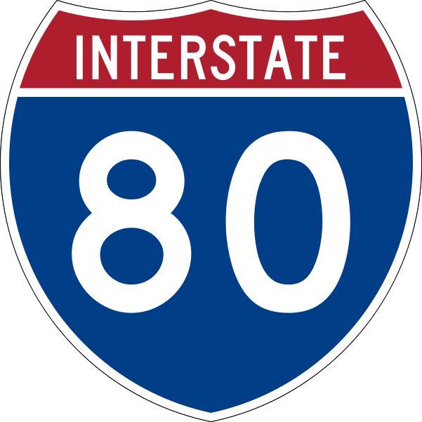
The shield indicating Interstate Highways for the USA.
Interstates that are odd numbered run north south and even numbered interstates run east-west. This is the same directional system as the previous section: US highways. What is slightly confusing is that Interstates are numbered in the opposite manner to US highways. In other words, even numbered (east-west running) interstates contain low numbers in the south and increase as you head north to the higher numbers near the Canadian border. Odd numbered interstates (north-south running) contain low numbers on the west coast and increase in number towards the east coast. I remember this interstate numbering system by thinking of California as the state with the lowest numbers both odd and even. Every interstate to the north increases and every interstate to the east increases.
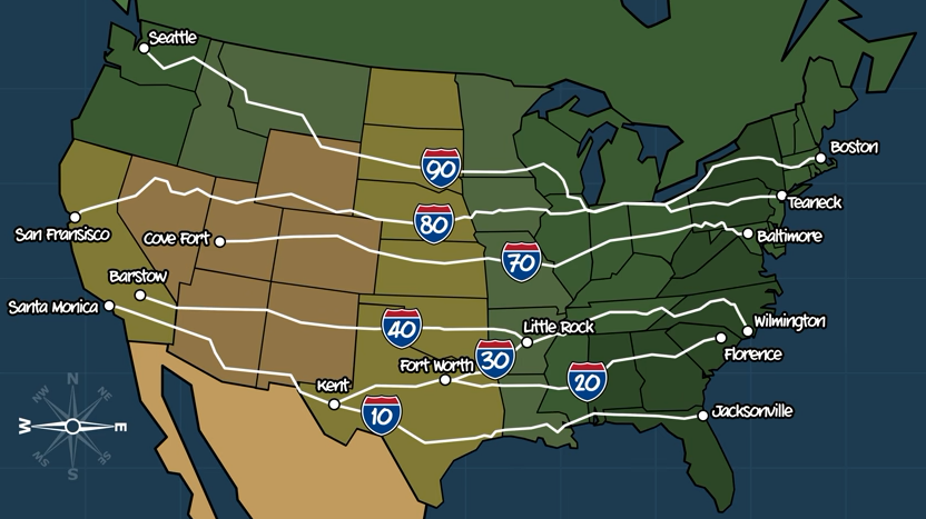
This map shows some of the even numbered US interstates that run east-west. The map also highlights that even numbered US interstate highway numbers gradually increase the further north you travel (I-10 is in the south of the US whilst I-90 in the north). Note: only the US interstates ending with ‘0’ are shown on this map so as to provide an idea of the US interstate highways system. Other even numbered US interstates aren’t shown but they do exist! (Image source: CCP Grey, Youtube).
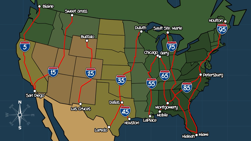
A map showing odd numbered US interstate highways. Notice that these odd numbered interstates run north-south. Also observe that they gradually increase in highway number as you travel east (I-5 is on west coast whilst I-95 is on the east coast). Note that only the odd numbered US interstates ending in ‘5’ are shown on this map so as to provide an idea of how the US interstate numbering system works. The other odd numbered US interstates aren’t shown however they do exist. (Image source: CCP Grey, Youtube).
US Interstate Minors
Three digit interstates are called ‘interstate minors’. These interstate minors run-off from interstate major highways and share the last two digits of the interstate major they run off. If an interstate minor highway has an even first digit it will deviate off from the interstate major and connect back to it. If an interstate minor highway has an odd first digit, it will deviate off from the interstate major and not connect back to it.
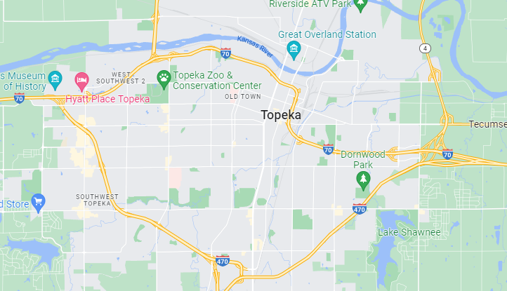
‘Interstate minors’ are interstates consisting of three digits with the 2nd and 3rd digit being the same as the interstate major that it runs off. For example, the interstate minor ‘470’ runs off the interstate highway 70. As the 470 starts with an even number, it connects back to the interstate highway 70. As the above map indicates, the I-470 deviates around Topeka.

Another interstate minor example is pictured above The interstate minor 180 runs off from the interstate major 80. As the 180 begins with an odd number, it will never connect back to the interstate major 80.
To elaborate on the memory side of things: US highways with a black and white shield have lowest numbers in Maine. Interstate highways with a blue and red shield have lowest numbers in California. Both of these road types have odd numbers north-south running (like the uneven US coast) and even numbers east-west running (like the even Canada border).
Canadian Highways
Trans-Canada Highways: as the name suggests, these highways span across the country of Canada. They are denoted by a marijuana leaf (I’m reliably informed that it’s actually a maple leaf) of white colour on a green background. The state is also sometimes listed on Trans-Canada Highway signs.

Trans-Canada Highways as they appear on the map

A shield indicating a Trans-Canada Highway
Provincial highways: Like the USA, Canada has an array of highway types that are bamboozling. Each state has its own unique highway shield that is valuable within the GeoGuessr game and these can be viewed below. They appear on the map typically in a similar fashion to their real world appearance (I went outside and experienced this ‘real world’ once). Often there is no state provincial shield visible but rather a white trapezium shaped sign with a black outline. The map matches the real world mostly in these cases.

A possible symbol indicating a Canadian Provincial Highway on the map

One of many possible signs indicating a Canadian Provincial Highway
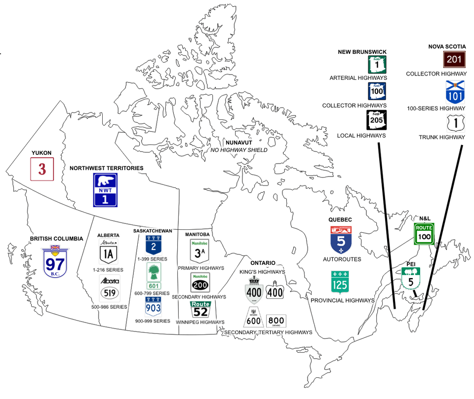
A map showing the various Canadian Provincial Highway shields. (Source: Pyrobove, reddit)
Mexican Highways
Federal highways in Mexico feature a black and white shield with a number and the word Mexico at the top of the shield. These highways are easily visible when zooming in on the map. Nonetheless, the numbering system of these highways starts in the north-west of Mexico and increases towards the south-east. North-south running federal highways are odd and east-west federal highways are even numbered (the same pattern as the aforementioned US). Essentially don’t worry too much about learning this system as the federal highways of Mexico aren’t like playing Where’s Wally/Waldo.

A Mexican federal highway shield. Note the curved sides and word Mexico on top. These features distinguish the shield from a state highway shield.
State highways in Mexico have a slightly different shield; with straight as opposed to curvy sides. The state abbreviation is written at the top of Mexican state highways which can prove particularly helpful. If you zoom into the map of Mexico to the right level, the states are named and it is fairly self-explanatory to correlate the state highway abbreviation to the associated state. The only slight room for confusion with Mexican state highways involves the state of Mexico which surrounds Mexico City. State highways here are abbreviated on signs as ‘MEX’ and shouldn’t be confused with the federal Mexican highways which have ‘MEXICO’ written on them.
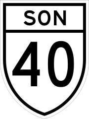
A Mexican state highway shield. Note the straight sides and flat top of the shield. The letters on the shield denote the specific state that the shield is from. By zooming in to the right level on the GeoGuessr map, you can work out the matching state. For this example, ‘SON’ represents the Mexican state of Sonora.
Brazilian Highways
I love Brazil. Its highway system is easier to explain than some previous countries *Cough USA Cough *.
Brazilian Regional Highways: These highways are numbered xx-yyy with the xx denoting the name of the state that the highway is running in and the yyy representing a number. An example is highway SP-280 which means the highway is in the state of São Paulo. Conveniently, the Brazilian states are listed on the GeoGuessr map (as well as the state initials) so you don’t require an in depth knowledge of them and can simply match up the initials with the state names. You can view the state’s names and initials at different levels of being zoomed in on the map. The below chart indicates what state the initials for each Brazilian regional highway represent. You don’t really need to memorise these as they are fairly self-explanatory and can be worked out in the spur of the moment whilst playing GeoGuessr.
DF= Federal District
AC= State of Acre
AL= State of Alagoas
AP= State of Amapa (an appropriate name)
AM= State of Amazonas
BA= State of Bahia
CE= State of Ceara
ES= State of Espirito
GO= State of Goias
MA= State of Maranhao
MT= State of Mato Grosso
MS= State of Mato Grosso do Sul
MG= State of Minas Gerais
PA= State of Para
PB= State of Paraiba
PE= State of Pernambuco
PR= State of Parana
PI= State of Piaui
RJ= State of Rio de Janeiro
RN= State of Rio Grande do Norte
RS= State of Rio Grande do Sul
RO= State of Rondonia
RR= Roraima
SC= State of Santa Catarina
SE= State of Sergipe
SP= State of Sao Paulo
TO= State of Tocantins
I’m in a state of disbelief that Brazil has so many states. After this poorly given, impromptu Brazil geography lesson, I should emphasise again that all of these Brazil regional highway abbreviations can be matched on the map using initials and without memorising the above list. Just remember to zoom in the appropriate amount to view state initials and zoom in slightly further to see the full state names.
Brazil National Highways: These are the highways that span multiple Brazilian states. They are named with the structure BR-xxx. BR denotes the country of Brazil and it can be handy to see these signs when playing GeoGuessr and immediately knowing what country you are in. The xxx doesn’t denote something rude but rather three numbers. There is a reasonably logical numbering system concerning these Brazil National Highways. Any number from:
000-099 denotes a highway travelling radially from the capital, Brasilia. In other words, think of Brasilia as a sun and any rays from the sun are these highways.
100-199 denotes highways running north-south.
200-299 denotes east-west running highways.
300-399 denotes diagonally running highways. Odd numbered highways run in the direction south-west to north-east whilst even numbered highways run south-east to north-west.
400-499 denotes a highway that connects two other highways.
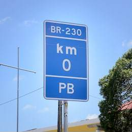
A Brazil National Highway sign
European E-Roads
Unlike every other thing in the world that begins with a single ‘E’, the ‘E’ in E-Roads doesn’t stand for ‘electronic’, nor does the name represent the outdated TV show ‘E Street’. Now I’ve mentioned what E-Roads are not, I’ll say what they are. E-Roads are a network of roads that stretch across Europe. Some numbered E-road span several countries. In tandem with E-roads, every country in Europe has their own localised road numbering system with non-E-roads.

A map showing the vast E-road network that spans Europe.
Even numbered E-roads (eg E-34) are typically East-West running. Odd numbered E-roads (eg E-37) are typically North-South running. The numbering of E-roads increases as you progress in a southerly and easterly direction. This means that E-1 appears in Ireland and Portugal as these are the westerly parts of Europe. E-99 appears in Turkey as this is an eastern part of Europe. For the even numbers, E-4 appears in Sweden and E-98 appears in Turkey. E-roads that end in a 0 or a 5 are cross-continental European roads.
E-Roads that contain 3 digits (eg E-451) are connecting roads known technically as class-B roads. The exception to this is odd numbered 3 digit E-roads numbered 101 or greater- these are major, E-roads. E-road signs are green with white lettering.
E-road signs have a green background with white lettering.
General European Road Numbering Signs

A map showing the road numbering systems and signs for each GeoGuessr relevant country in Europe. Note that the road sign that appears the highest on each country in the map is the more major type of road in that country. The road types gradually become smaller as you look down each country on the map until the bottom road of each country on the map is minor. A larger version of this map can be seen here.(Source, reddit user, u/Melongated).
Russian Federal Highways
Ah yes, we meet again my old foe. Russian highways are confusing partially due to some being renamed/renumbered and the original signs still being in place. Russian Federal Highways have either an M, A or P/R prefixing the road number.
M: Roads numbered M-1 to M-10 connect Moscow with a neighbouring country or connect Moscow with a Russian administrative centre.
P/R: Roads with a ‘P’ prefix are actually written in Russian with the ‘R’ symbol due to their writing system of Cyrillic. These ‘R’ symbols as they will appear in Russia are followed by a number. ‘R’ roads link administrative centres in Russia. I have noticed on a map that these roads tend to be numbered with lower numbers further north (numbers less than 120 being north of Moscow typically) and higher numbers further south of Moscow (above 120) but I haven’t read of this system online so be skeptical of my possibly crazy ramblings.
A: Access roads in Russia have the prefix ‘A’. Once again, be skeptical of my observations but roads numbered A100-A110 seem to commonly be cyclic roads around the outskirts of Moscow. Roads A146-A164 seem to be in the south-west corner of Russia.

Look for signs like this in Russia. This one says road A-166 in smallish writing.
These 3 types of Russian roads are the best maintained types of roads in the country and are normally paved and relatively well maintained. In the far east of Russia some of these roads may still be gravel. A map of Russian Federal Highways can be found here.
Road Markers: Fortunately, amidst the geographical and language barriers of Russia there are some further clues. Poles (the objects not the nationality) on the side of the Russian roads with blue signs have numbers on them. These numbers indicate the distance to the start/end of the road. The numbers are printed on both sides of the poles e.g. 6 and 31. In this instance you can determine the road is 37 kilometres long and you are 6 kilometres from one end and 31 kilometres from the other end. In this case it is usually wise to travel towards the closest road end e.g. the 6 kilometre one and to try and gain information at the roads end/junction. An important stipulation with Russian km markers; as you approach a sign and read it as the driver of a vehicle, it tells you how far you have travelled on the highway, the other side of the sign which you have to turn around to see once passing it tells you how far you have left on the highway. For instance, if you are travelling on a 100km highway and have travelled 99km and are only 1km away from the end, the marker will say 99km. Contrastingly, if you have just started driving on the 100km highway and have travelled only 1km, the sign will say 1km. If a Russian road has numbers above 1000km on it, the road is likely the one to Vladivostok (the city situated just slightly north-east of North Korea).

A typical Russian road marker pole. This one shows that the road has extended 238km to this point.
Great Britain Highways
M Roads
Motorways on the island of Great Britain start with an ‘M’ followed by a number eg M23. These motorways are major roads that are fairly easy to find on the map. Nonetheless, there is a method to their numbering system. The first digit of M roads indicates what region of GB the road resides in. For instance, if you are on the M53, then you focus on the first digit of 53 which is 5. On the below map, the M53 road must be in the zone marked ‘5’.

A map showing motorway zones for Great Britain. If you find a road starting with an ‘M’, the first digit of the road will indicate which area on the above map the road is in. (Source: Nilfanion and Dr Greg, Wikipedia)
A and B Roads
‘A’ and ‘B’ roads in Great Britain are typically harder to find on the map than M roads and thus you should read this section more carefully than the previous section (I should have put this before the previous section). Roads that start with an A or B prefix will follow with a number eg A606. The first digit of this number will determine where in GB this road can be found. The below map indicates these zones. You need to learn, nurture and perhaps even grow to love the below map.

A map showing the zones for ‘A’ and ‘B’ roads in Great Britain. The first digit of the ‘A’ or ‘B’ road indicates which of the above zones that road will be in. An example is that road A299 is found in the zone marked ‘2.’ (Source: Liftarn, Wikipedia)
It should be noted that Northern Ireland’s road numbers and letters resemble Great Britain’s road numbers and letters but they in fact have their own system. Be mindful that if you are spending an inordinate amount of time looking for a road in GB, it may actually be in Northern Ireland.
Spanish Roads
Anagram the country ‘Spain’ and you end up with ‘pains’. This is an apt description of their seemingly complexly numbered road network. Despite their challenging veneer, pinpointing roads in Spain can be done before you can say Don Quixote, just read ahead (and keep reading the rest of the article unless you for some reason are just a Spanish road aficionado).
Interurban motorways in Spain typically start with A or AP followed by a number eg AP-71. Radial motorways (R roads) and National roads (N roads) are two more types of roads in Spain. European roads (E roads) are clearly labelled and easy to find across Spain and indeed all of Europe. These European roads are doubly unique in Spain as they appear on signs with a dash between the E and the number eg E-90. This contrasts most of Europe that has no dash between the E and the number eg E25. This can make recognising or excluding Spain easy just by looking for the dash on E roads.
Many road numbers in Spain start with the letter(s) representing their region. Eg ‘EX-202’ for a road in the region of Extremadura. The following is a list of road code abbreviations and their corresponding Spanish province.
AC= A Coruna
AG= Galicia
A= Alicante
AL= Almeria
ARA= Aragon
AV= Avila
AI= Aviles
AS= Asturias
B= Barcelona
BI/GI= Basque Country
Bu= Burgos
C= Catalonia
CA= Cadiz
CM= Castile-La Mancha
CT= Cartagena
CS= Castellon de la Plana
CO= Cordoba
CV= Cuenca
CV= Valencian Community
EL= Elche
EX= Extremadura
GJ= Gijon
GR= Granada
H= Huelva
J= Jaen
Le= Leon
LL= Lleida
LO= Logrono
LR= La Rioja
LU= Lugo
M= Madrid
MA= Malaga
MA= Balearic Islands
MU/RM= Murcia (How Americans pronounce “America”)
O= Oviedo
P= Palencia
PO= Pontevedra
PT= Puertollano
SA= Salamanca
SC= Santiago de Compostela
SE= Seville
SO= Soria
T= Tarragona
TO= Toledo
V= Valencia
VA= Valladolid
VG= Vigo
ZA= Zamora
Z= Zaragoza
There are some more Spanish road prefixes e.g. for Andalusia, the ‘A’ prefix exists with green or orange signs, contrasting the blue ‘A’ signs for interurban motorways.
The Spanish regions don’t appear on the GeoGuessr map. Despite this, memorising the Spanish regions isn’t necessary as on most occasions the region is named after the major city within the region. If you see a road sign eg TO-22, then look at the GeoGuessr map for large Spanish cities starting with ‘T’ or ‘To’. You will notice the city of Toledo just south of Madrid and within a few seconds you will see the road: TO-22.

A map showing the provinces of Spain. Many Spanish road numbers have letters preceding them indicating the province they are found in. (Source: http://www.travelrepublic.co.uk)
LZ, FV, GC, TF, HI, LP, GM/CV before a number indicates the specific island a road is on within the Canary Islands: LZ= Lanzarote, FV= Fuerteventura, GC= Gran Canaria, TF= Tenerife, HI= El Hierro, LP= La Palma, GM/CV= La Gomera.
Norwegian Roads
Norway! The country that brought the world IKEA, ABBA and Swedish meatballs. I’m now informed this wasn’t Norway. Something Norway definitely did bring the world is Norwegian National roads. Signs for these roads look similar to E-roads without the E. The signs have a green background and white lettering. National roads contain between 1 and 3 digits. The first digit denotes where in Norway the road is located.
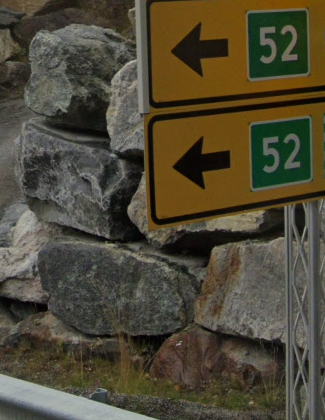
A National road sign in Norway

National roads in Norway appear like this on the map.
Primary county roads in Norway contain between 1 and 3 digits. The signs are white with black lettering. The first digit also denotes where the road is situated.
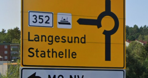
A Primary county road sign in Norway

Primary county roads in Norway appear like this on the map.
By simply looking at the first number of the National or primary county road, you can determine the region in Norway you are located. I created the child-like quality map below to provide a general idea of the zones of the first digits of Norway’s roads. There are the occasional exceptions to the zoning number rules such as routes 12 and 17 appearing in the North of Norway as opposed to where they should occur around Oslo (if you are reading this Norway government, please change these roads. Also, I would like to thank your country for IKEA, ABBA and Swedish meatballs.). It’s a good idea to get a general idea of the Norway road number zoning system so you can quickly zoom into the map in the right area.

A general guide to where Norway’s roads are located. By simply looking at the first digit of the road number, you can work out which region you are in. For instance, if your road starts with a 4 eg 42, then you are in the south or Norway. The roads that defy the zoning, numbering rule are routes 12 and 17 which are located in the north of Norway. (Map source: Poorly made by me).
Swedish Roads
If stereotypes are true, the Swedes produce attractive roads (and people). It is these attractive roads that I’ll be focusing on today. National roads in Sweden are denoted by blue background signs with white lettering. National roads will contain 1 or 2 digits and always be less than 100. Locating national roads in Sweden is fairly easy. The numbers gradually increase from low numbers in the south of Sweden to high numbers in the north of Sweden. If you see National road number 9 in your travels, you know to focus on the southern part of Sweden on the map to find the corresponding road. If you see National road number 99 then you know to look at the northern part of Sweden. If you see number 9 and ¾ you are playing the wrong game and should be playing Harry Potter.

One and two digit roads in Sweden with this blue sign denote national roads. The numbers increase the further north you travel in Sweden. Road number 9 is in the south of the country and road 99 is in the very north of the country.
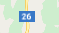
This is what Swedish national roads look like on the map.
Swedish county roads have the same signage as the national roads- blue background and white lettering. The Swedish county roads are unique as they contain 3 digit numbers as opposed to the national roads’ 2 digit numbers. Swedish county road numbers range from 100 to 404. Incidentally, this 404 number seems to pop up regularly on my computer screen. Like the national roads, the numbers increase the further North you travel. This means road number 100 is in the south of Sweden and road number 404 is in the north of Sweden.

Swedish county roads contain 3 digits and range from 100 to 404. The lower numbers are in the south and numbers increase as you travel north.

This is what Swedish county roads look like on the map.
Finnish Roads
The efficient and simple road numbering system in the Nordic countries comes to a grinding halt (or a ‘Finish’) when we encounter the Finnish. The 1st class main roads in Finland are denoted by red signs with white lettering. These 1st class roads range in number from 1 to 39. The 1st class roads in Finland connect the major Finnish cities. The 1st class roads numbered 1-7 radiate away from Helsinki with the numbers increasing in a clockwise direction. 1st class roads 8-10 radiate in a clockwise order away from the city of Turku and 11 and 12 radiate in a clockwise order away from Tampere. The remainder of the 1st class roads- 13 up to 39 begin in other large Finnish cities.

1st class Finnish roads range in number from 1-39. These roads connect major Finnish cities. These road numbers appear with a red background on signs.

1st class Finnish roads appear like this on the map.
The 2nd class main roads in Finland are denoted by signs with yellow backgrounds and black lettering. These roads range in number from 40 to 99. 2nd class main roads connect regional centres in Finland. As a general rule, 2nd class main roads in Finland increase the further north you travel. This means roads numbered closer to 40 will typically be in the south of Finland and roads numbered closer to 99 will normally be in the north of the country.

2nd class Finnish roads range in number from 40-99. These roads generally increase in numbering as you travel north in Finland.
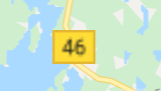
2nd class Finnish roads as they appear on the map.

This map of Finland illustrates that 1st class roads (those with red signs, shown with red lines) connect the major Finnish cities. The map also shows that 2nd class roads (those with yellow signs, shown with yellow lines) connect regional centres in Finland. (Source: Migro, Wikipedia)
The third type of road in Finland are regional roads. These roads contain 3-digits ranging from 100 to 999. Regional roads are denoted by signs with a white background and black lettering. These roads increase in numbering as you travel north. This means road number 100 is at the South of Finland and road number 999 is at the north of the country. This must be somewhere so unimaginably cold that I can’t use a metaphor to imagine it as it’s unimaginable.

Regional roads in Finland contain 3 digits. They increase in numbering as you travel north. This means road 100 is in the south of Finland and road 999 is in the north of Finland.

Regional roads in Finland as they appear on the map.
The last type of GeoGuessr relevant road in Finland are connecting roads. These road numbers contain 4-digits ranging from 1000-9999. The Finns really are fond of using numbers instead of road names aren’t they. Connecting roads feature a sign with a blue background and white lettering. Connecting roads increase in numbering as you travel north. This means that road number 1000 is at the south of Finland and road 9999 is at the north of Finland. These 4-digit connecting roads often stem from the aforementioned 3-digit regional roads. In other words roads 5511, 5512, 5513 and 5514 will all be near regional road number 551 as they share the first 3 digits of 551. Based on this, if you see a sign for road number 4576, it may be worth looking for the regional road 457 and hopefully 4576 will be somewhat nearby. I have now reached the ‘Finnish line’ for this section
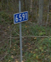
Connecting roads in Finland contain 4 digits. They increase in numbering as you travel north in Finland. This means road 1000 is in the south of Finland and road 9999 is in the north of Finland.

How connecting roads in Finland appear on the map.
Japanese Highways
In Japan, prefectural roads are denoted by a blue hexagonal logo containing a number. These are difficult to find on the map without more markers and if you decide to search for these numbers on the map without any clues, say goodbye to your weekend.

How Japanese prefectural roads appear on the map (they are hard to find).

How Japanese prefectural roads appear on signs: a number within a hexagon.
The most useful road numbers in Japan are the national highways. Their logo features a blue ‘triangle’ with rounded edges. *Cue hordes of mathematicians shaking their calculator carrying fists at me for calling the shape a triangle.*
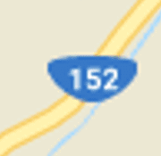
How Japanese national highways appear on the map.
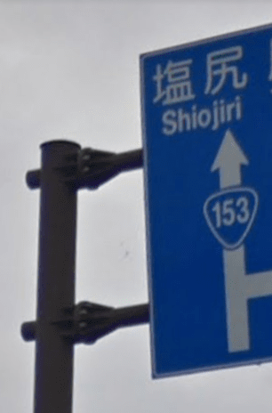
The triangle with rounded edges denotes Japanese national highways.
These national highway numbers can be found on the map. If you don’t wish to learn the Japanese national highway numbering systems (described below), the best way to find a national highway on the map is as follows- Say you see the national highway number 153 on a sign. Zoom in to the map of Japan and look for highway numbers on the map that are near 153. These may be in the 143 to 163 range. After panning up and down the map of Japan, you should see one of these numbers within a few seconds. As the highway numbers generally get higher as you go south, you can then zoom in closer on the map and look just above or just below the number you spot. If you see the highway number 149 on the map whilst looking for 153 then simply look in the area just south of highway 149 for highways 150, 151, 152 and 153. You will know you have gone too far south if you reach 154. This technique to find Japanese highways always works for me and using it will mean you can find highway numbers on the map fairly quickly.
If you don’t like the above approach, you can memorise where the Japanese national highways are located. Below appears a table explaining the numbering mechanism of these national highways aka curved triangle roads.
A table indicating where to look for specific Japanese national highway numbers (the roads denoted by rounded triangles containing a number). An explanation of this table occurs in the next paragraph. (Source and more info on Japanese roads: https://sites.google.com/site/roadnumberingsystems/home/countries/japan)
The top section of the table details 1 and 2 digit national highway roads whilst the bottom section explains where to find 3 digit national highway roads. The right half of the table refers to roads on the northern island of Hokkaido and the left column of the table refers to the remainder of Japan. The place names e.g. Aomori to Okinawa explain where a specific road is found. Aomori is on the northern part of the main island and Okinawa Island is south of the main island. Using the table to find road numbers can take a bit of practise. If we see road number 338 within a ‘triangle’ in GeoGuessr we look at the table to see where it fits. “338-390 Aomori- Okinawa, direction of increase N-S”. This information tells us that road number 338 will appear near Aomori at the northern tip of the main island. The road numbers will get larger until road number 390 is found near Okinawa at the southern part of Japan. A road numbered half way between 338 and 390 e.g. road 365 will be found approximately half way between these points.
Other Countries Highways: If anyone is actually reading this article and has read this far then you deserve a congratulations. I won’t go through any more countries highway systems at present. If you would like the highway numbering system of a country poorly explained by me then please leave a comment and I’ll update this article to include a new country. Some other countries highway shields can be found here.
Mile and Kilometre Markers
Mile and Kilometre Markers: I have already touched on the kilometre markers used in the vastness of Russia but many other countries also have signs with numbers on the sides of their highways. There is no universal rule for these numbered signs and even within the same country, different types of numbered signs indicate different things. Some countries have markers indicating how far the nearing exit road is, how far the nearest state is, how far the nearest county is, how far until the end of the road and various other listings. These mile and kilometre markers can be useful to GeoGuessr players as you decide which way to move in the game, it’s often sensible to move towards a zero marker indicating a new road/state or some other potential information. Also you may decide to change direction if you see mile marker 999 then 998 then 997 unless you want to spend the foreseeable future travelling on a desolate road.
Junctions
Junctions are sometimes the fantasies of GeoGuessr players. JCT is often the abbreviation used on signs which much to my surprise doesn’t stand for a new RnB group but the word ‘Junction”. These JCT signs pop up typically around 400 metres away from an intersection.
Warning Signs
Warning Signs: An object whose purpose is to inform citizens of impending danger has positive connotations within GeoGuessr. Warning signs that are diamond shaped and yellow are ubiquitous in North and South America, Australia (and New Zealand if you count it as a real country), Ireland (it’s very useful for picking Ireland from the rest of Europe), Japan and South-East Asia. If you spot a triangular warning sign with a red outline and a yellow colouring then you are in luck; not because you may be perilously close to a cliff but because only a handful of eclectic countries use these warning signs. These countries include: Greece, Finland, Sweden, Iceland, North Macedonia and South Korea. These yellow coloured and red bordered signs are useful for distinguishing Finland, Sweden and Iceland from the white coloured and red bordered signs of Norway and Denmark. Other shaped signs (such as circle-shaped signs) in Finland, Sweden and Iceland also have this unique red outer and yellow colouring. Poland is unique as it has the red outline and yellow filling but the red outline is very thin. Virtually the rest of the GeoGuessr world uses the standard triangle with a red border and white centre to warn of foreboding doom.


Road warning signs around the world. (Source: Fry1989, Wikipedia). A larger map can be viewed here.
This type of warning sign (a thick red outline with yellow colouring) with various images on it occurs in Finland, Sweden, Iceland, Greece, North Macedonia, Vietnam and South Korea.
This type of warning sign (thin red outline and yellow coloured) with various images on it occurs only on Poland.

This type of warning sign (yellow and diamond shaped) occurs throughout virtually all of North and South America as well as Australia, New Zealand, Ireland, Japan and most of south-east Asia.
This type of warning sign (with various images on it) featuring a red outline and white middle occurs throughout most of Africa, Asia (not south-east Asia) and Europe.
General Clues
- Geography
- Houses
- Flora
- Cars
- Utility Poles
- Bollards
- Flags
- Flag Trick (Battle Royale)
- Internet Domain Name Suffixes
- Other Clues
Geography
Geography isn’t just a subject you choose at school if you want to bludge. It’s also a useful aspect to navigating and pinpointing locations within GeoGuessr. If you see what resembles the sea to your East and you are in the USA, then you know you are probably on the east coast of the country gazing wishfully into the Atlantic Ocean. If you see a mountain range to your north and you are in some obscure and tiny European country then placing the pin on the map just south of the mountain range is sensible. Even if you just see the semblance of a hill in the background, you can use this knowledge to your advantage. The map on GeoGuessr, when zoomed in to the precise amount will show mountains. Forests are also clearly visible on the map and this is another factor to consider when placing yourself.
One of the most important aspects to GeoGuessr is to match up the colours of the grass and plants you are looking at in GeoGuessr with the colours on the map. For instance, if you think you are in the USA and you see lush, green surrounds then look on the map for what parts are coloured dark green; the eastern and far western parts of the country. If you see dry grass around you that is tinged yellow then click on the map where there is yellowish colours such as the central and western parts of the USA. This process holds true for the entire world when the map is relatively zoomed out- match the grass colours in GeoGuessr with the colours appearing on the map. Once you zoom in on the map to the point that the colour yellow vanishes, the meaning of the colour green changes to represent forests and national parks.
Note the colour of the grassland and lack of vegetation.

The above GeoGuessr location was located within southern Saskatchewan which is depicted on the map as a similar colour to the grassland. The GeoGuessr map, when zoomed in to the correct degree provides clues about the landscape around the world and thickness of vegetation.
When you zoom in further, the meaning of the colours on the map changes. Green represents forests and national parks at these higher zoom levels. The grassland colours are no longer relevant at these zoom levels.
Houses
Becoming aware of the types of houses in different countries and regions is of the utmost importance in GeoGuessr. A general guide to determining what country you find yourself in is to evaluate the expensiveness of the houses. If you have a mansion in front of you then it’s unlikely you are in the midst of Uganda, unless it’s some warlord’s house. Are we still doing the stop Kony movement? Houses can look vastly different in the same country depending on whether they are in an urban or rural area. This section is mainly focused on the houses you will see outside of large cities as large cities are often crammed with apartments. These are the main houses to be aware of in GeoGuessr. In the individual country section I’ve also included some more esoteric houses.
North America

The north-east part of the US tends to have this grand, Colonial style of wooden, (typically white-coloured), two-storey house that has a fairly steep roof. Ranch style houses often appear in the southern USA states. California bungalows appear (as the name suggests) throughout California. Conch houses are found in Florida.

The eastern parts of Canada have many houses that are made from horizontal pieces of wood.
Urban Mexico (which is where most of the population lives) often consists of houses and buildings that have walls on the narrow footpath. The buildings are typically made of concrete.
Europe

The majority of houses in the rural part of Ireland have some semblance to the house pictured. They are generally either white coloured or stone and have these dark roofs. Looking at the houses from the road, they tend to be wide but not very deep (they look like a rectangle from above). They are normally one or two storey. Brick is rarely visible in Irish buildings whilst it is quite common in Great Britain. Ireland tends to have longer driveways than Great Britain.
Scotland tends to have a higher percentage of grey coloured houses and buildings than England.
Townhouses, like those pictured, are common in the U.K. Bricks are used to construct a large portion of houses in Great Britain whilst in Ireland, brick is very rare.
Many Portuguese houses are white or light-coloured and many have tiled, terracotta coloured roofs.
Spanish houses are generally either white or a shade of some warm colour such as red, orange or yellow.

Buildings in Andorra are typically multi-storey, affluent looking and made of gray stones compressed together. This unique, stone building style is the best way to identify Andorra.
French towns typically consist of two-storey buildings made out of visible stone. The buildings virtually join one another and are built right on the edge of the footpath.
Houses in Brittany, a western region of France, are coloured white with dark roofs.
Many houses in Belgium have an older look to them. Houses with a visible red brick exterior are a common sight in Belgium. Most of the houses in Belgium have slanted roofs.
Townhouses are the most common form of abode in the Netherlands. Some townhouses have flat roofs whilst others have extremely steep roofs.
The standard Mediterranean house style is popular in Italy. It features a white (or light coloured) exterior and a terracotta tiled roof.
Houses of this distinct reddish-brown colour are a common sight in the Nordic countries.
Greenland tends to have a range of colourfully painted houses.
Houses in Denmark are typically painted light colours. They also have steep roofs with new-looking tiles. Although Danish houses can have visible brick, visible brick houses are much more common in Belgium, the Netherlands and France.

Much of the German Street View coverage is focused around greater cities. German houses in these areas tend to be apartments between 3 and 5 stories high, painted fairly drab colours and situated very close to the road or footpath.

Austrian houses often have slanted, dark-terracotta coloured roofs. The houses are often two-storey, well-maintained and are painted light colours. The houses regularly have TV satellite dishes.
The houses in Switzerland are often wooden and multi-storey with terracotta-coloured slanting roofs. Swiss houses are known for their high number of window shutters.

Polish houses often have small wooden or metal fences around them.

Rural Lithuanian, Latvian and Estonian houses often have eternit roofs (that look like corrugated iron) that are different shades of gray/silver. The roofs tend to face the road. These houses are one of the easiest ways to identify the Baltic countries.
Slovakia and Czechia houses are typically cream-coloured with slanted terracotta roof tiles that have a unique shade.

Slovenian houses are typically fairly close to white (often a very light pink) in colour and two-storey. They often have pronounced, triangular roofs. Roofs are commonly brown or terracotta coloured. Sometimes the very top, pointed part of the roof is flat (see the far house in the right of the image).
Single storey houses are more common in Hungary. These houses have lower roofs than many of the previous countries that have been mentioned. Hungarian houses are often a light colour such as pink. The standard roofs are a pink/red/terracotta colour. The roofs are less likely to be like a triangular half-open-book shape than the previously mentioned countries. The roof edge elevations tend to meet together at a few common points on top.

Houses in inland Croatia tend to come in more of a range of colours and styles than many of the previously mentioned countries. The roofs’ colours tend to be shades of terracotta with more of a range of these colours than some other countries. Croatian houses are commonly two-storey.
Greek houses are usually white or light coloured. They typically all share the same shade of terracotta as their roof colour. Like Albania, Greece has some water heaters on the roofs of their houses.
Small Romanian towns often have houses with pyramid shaped roofs. The houses are commonly separated from the footpath by metal fences.
Although Albania is full of two-storey houses, the houses are typically run-down and look unfinished and lack windows or bricks. Water heaters also commonly appear on Albanian roofs.

Houses in North Macedonia mainly have terracotta tiled roofs and multiple chimneys. They are often two-storey and occasionally you will see houses with a curved front element; for example, the house on the left has front windows that curve outwards.
Montenegrin houses tend to come in a range of styles and colours. They most commonly have the terracotta coloured roofs.

Serbian homes are another great way to recognise the country. They often look like cottages and are typically fairly run-down. They often also have square-prism shaped chimneys.

Bulgarian houses feature roofs that aren’t very steep. The roofs also tend to be the same shade of terracotta. Bulgarian houses are predominantly light coloured or have a brick exterior. The houses are often run-down.

Rural Ukrainian houses come in a range of styles. Those houses pictured, with a triangular prism roof, small window upstairs and made of wood are common in Ukraine. Wooden fences are common around Ukrainian houses.
Russia has a range of house styles. One of the more common are wooden houses that have triangular-prism shaped roofs. Wooden fences are also common around Russian houses.
Streets in Maltese cities are narrow, often with high rise, old buildings that are the same creamish colour.
Oceania

Houses in the Australian state of Queensland are most commonly made of horizontal pieces of wood. They are also often elevated off the ground (not necessarily as high as the house pictured).

Bungalow style houses are particularly common in the Australian suburbs.
New Zealand houses are often white in colour and bungalow-styled. White coloured houses are much more common in New Zealand than Australia and this can be another clue to help distinguish between the two countries.
Africa
High walls and fences around houses are a common sight in South Africa.

Ghanaian shops and houses often have corrugated iron roofs.
The urban areas of Senegal typically feature brick buildings painted white or light colours. These structures often show signs of wear such as parts of the building crumbling or the painting having eroded away.
Asia

Bhutanese houses and apartments can be quite elaborate looking. They often feature flat roofs that extend beyond the walls, white walls, arch windows and detailed wooden elements.
There are a number of common house styles in Japan. The first of these is the house with a compacted square-based pyramid for a roof. Japanese houses are often two-storey. This style of house also has a roof for its lower storey.
Most South Korean residents live in apartments. Despite this, there is quite a range of house styles in the country. A common feature of South Korean houses involves having elaborate roofs. This includes having decorations, protrusions or stylised parts to the roof. In addition, the corners of the roofs often have pieces that arch upwards.

Many Cambodian houses are elevated on posts. Some homes will have part of the home elevated on posts and the other part of the home on the ground.
Thai houses and buildings come in a huge range of styles. They often have corrugated iron roofs or roofs made from tiles like the image above. Thai houses can best be distinguished from Cambodian houses as Thai houses are much less likely to be elevated on stilts. Many Thai houses can also look quite affluent and be two-storey and fairly large. Affluent houses seem rarer in Cambodia.

Taiwanese houses are most commonly boxy in shape.

Most houses and buildings in the UAE are white or light coloured. They also tend to be boxy in shape and have flat roofs.
Apartments are often this cream colour in Jordan. This style of building tends to be 3-4 stories high, a rectangular prism in shape with a flat roof and many windows.
Cream-coloured apartments spanning at least several stories are the most common form of habitation in most of Israel and Palestine.
Mongolia has many small villages and towns. These areas are often contained by wooden fences. The houses tend to have bright roofs of different colours.

Indonesian houses most commonly have terracotta/brown coloured tiles on their roof. Some of the more remote Indonesia houses/businesses have corrugated iron roofs. These corrugated iron roofs are more common on Sulawesi, Borneo and Sumatra.
A large number of houses in Malaysia tend to have some form of vertical column as part of the house or holding up the verandah. This is a fairly unique feature that is rarely found in other countries. Malay houses often have corrugated iron roofs that are triangular prism shaped.

Houses in the Philippines come in a wide range of styles. The most common roof type in the Philippines features corrugated iron, normally in a triangular formation. The second most common roof type in the Philippines is a hand woven roof that uses something resembling reeds.

Sri Lankan houses most commonly feature terracotta tiles on their roofs. There are normally concrete walls separating Sri Lankan houses from the narrow, paved paths that are found everywhere in Sri Lanka.
Houses in Singapore tend to be double storey and very affluent.
Many Turkish residents live in apartments that are a number of stories high with a terracotta, tiled roof. Some of the higher Turkish apartments have flatter roofs.
South America

Brazilian houses come in wide range of styles. They are made from various materials, can have virtually every style of roof and can come in a range of colours.
Argentina and Uruguay tend to have flat roofs, visible brick making up lots of houses and if not visible brick then painted brick. The bricks are often quite large in these countries.
Ecuadorian houses come in a high range of styles. They can also have any roof style from tiles to corrugated iron to vines. Ecuadorian houses are most commonly built with gray coloured bricks. This contrasts most other South American houses which are mainly built using red brick.

Colombia often has colourful houses with corrugated iron roofs.

Peruvian houses can often be brick or be painted a range of colours. The Peruvian roofs tend to be flat. The houses are typically very low in height. If a Peruvian houses is built out of brick, it is often a brown-coloured brick. This brick colour is fairly rare in South America outside of Peru.

Bolivian houses tend to look quite similar to Peruvian houses. They are mainly made of red brick and have flat roofs. The bricks tend to be quite large. This contrasts the browner, smaller bricks used in Peru.
Houses in the south of Chile (and Southern Argentina) tend to be wooden, painted a range of bright colours and have slanting roofs made from corrugated iron. Houses in central Chile are more likely to have terracotta tiled roofs.
If you are interested in extending your architecture knowledge and learning from someone who actually knows about architecture and housing styles, then I recommend Simi’s European architecture videos. He has made over 11 hours of videos explaining the subtle differences between European architecture. View them here.
Flora
I won’t pretend to know anything about trees/plants (I know so little that I can’t think of any more categories of flora to list). If you do have a botanical-bend then I doth my fedora to you. Birch trees are found only in the northern hemisphere and if you are in the USA and see a bunch of birch trees then you are probably fairly northern. Eucalyptus trees are found almost exclusively in Australia and they can be useful for identifying this country on bland expanses of road (if you are interested in how not to rescue a koala from one of these trees, read my experience here).
Pine trees are mainly found in the northern hemisphere. Fir trees AKA Christmas trees are located in the northern hemisphere with colder northern areas and mountain regions home to these trees in abundance. A good general rule to determine your location using coniferous trees is to examine the density of these trees in the region. If you have wall to metaphorical wall of these trees then you are probably close to the Arctic region. If these trees are intermingling with other trees then you are likely further south. Savanna trees have a unique look especially the umbrella thorn acacia and point to you being in Africa. Trees with leaves matching the colourful hues of the sunset are found mainly in North-Eastern USA and South-Eastern Canada in autumn months.
When it comes to GeoGuessr, I rarely look at individual trees before guessing. I tend to look at the general landscape and get a vibe of where I am positioned. Having said that, this is a guide of how to do well in GeoGuessr. If a guide on performing neurosurgery said ‘just get a vibe of things’ rather than going into details, it wouldn’t end well. For this reason, I’ll give this tree describing business a shot.

North-western USA largely consists of thick forests with this specific type of tall tree.

Cornfields are most common in the US and Southern Europe.

A map showing the corn production distributions across the USA. The areas that are coloured dark-green are where you are most likely to be positioned if you are next to a corn field in GeoGuessr. (Source: The US Department of Agriculture).

A map showing corn production regions of Europe. Note that the primary corn countries are France, Italy, Romania, Serbia and Hungary (Source: Eurostat).
Olive trees can be found around the Mediterranean.

Olive tree distribution in Europe appears above in a coincidental ‘olive’ colour. Mostly Mediterranean areas are home to olive trees, with the bulk in Spain, Italy, Greece and Portugal.

The Irish landscape often has hedges alongside the road. Hedgerows are also very common among the southern part of England.

Birch trees are only found in the Northern Hemisphere and are typically found north of the 40th parallel. If you see birch trees (the white coloured ones) on the side of a European road, you are likely in a Nordic country. Finland seems to have more birch trees than Sweden and Norway. The further north you travel, the thicker the density of birch trees. They can be found elsewhere in Europe, including the northern Baltic areas. Birch trees can also be found in North America, namely right across Canada and the northern parts of the US.

The eastern half of Russia contains many of these trees. They have a thin trunk, are relatively short and have pine needles. They are often found in large groups and can be a great way to work out if you are in eastern Russia.

Trees often have black coloured bark in the northern part of Australia, especially around Darwin.

Australia stands out thanks to Eucalyptus trees. They are typically tall with white bark.

These short trees are a common sight in parts of Botswana. They often don’t have leaves in the Street View imagery.

Japan’s northern most island- Hokkaido (and sometimes northern Honshu) house this unique cabbage looking vegetation.
These trees, known as oil palms, are found in Indonesia, Malaysia and southern Thailand.

These trees (similar to Australian Eucalyptus) are found in the Andes.
Parana pines are these unique looking pine trees that have no branches until the top section of the tree. The branches span from the tree almost horizontally. Parana pines are most commonly found in the Brazilian state of Parana and the two states to the south of Parana- Santa Catalina and northern Rio Grande do Sul.

These trees (that remind me of African acacia) are found in the northern part of Peru.
Pine trees are mainly found in the Northern Hemisphere.
A fir tree. These are typically found in colder regions.

This umbrella thorn acacia is found across large swathes of Africa and parts of the Middle-East.

A type of palm tree. Palms are typically found in the tropics.
The palm tree, as seen above, has many variations that typically include a similar type of leaf. Even to fellow tree ignoramuses they should stand out and can help in pinpointing your location. The below map shows the distribution of palm trees across the world. They are mainly found in South America, Central America, Florida and California, Africa, Southern Asia and Northern Australia.
A map showing the distribution of palm trees across the earth.
If you actually understand trees then the below map may be of interest to you. It shows the woodland and forested areas on this pale, blue dot we call earth. It also indicates the specific type of tree found in each area. Warning: you may need to be a tree expert or someone treading the fine line between tree enthusiast and tree lover to interpret the map.

A map showing the forest and woodland distribution across earth as well as the specific type of tree found in each forest and woodland area. A larger map can be viewed here.
If you are interested in learning about what trees/plants are native to which parts of the world, then I highly recommend checking out Alok’s amazing interactive map. It focuses on trees and plants but also covers some landscapes. In addition, if you wish to improve your knowledge of where certain vegetation is located, you should play ‘A skewed world’ map. If you play no moving, panning and zooming, you won’t be able to use clues like road lines, meta and cars as you face away from the roads. You will be forced to pick up vegetation clues and grow like the very trees you are looking at. Play ‘A skewed world’ here: https://www.geoguessr.com/maps/6165f7176c26ac00016bca3d
Cars
Stereotypically, ppl who rite lyk dis are car enthusiasts. These types of people are useful to have around in GeoGuessr but not necessarily in other aspects of life. Much in the same ilk as being ignorant about trees, I have a similar blind spot for cars so please forgive any inaccuracies that I write. Within the GeoGuessr game, there is an assortment of things blurred out; sometimes this extends to car logos. Such is my automobile naivety, I struggle to identify specific car brands without the logos.
In the USA I have noticed a large amount of ‘expensive utes’ also known as personal trucks. Excluding major cities, a high portion of cars I see while moving along the street are these ‘expensive utes’. These ‘expensive utes’ are often Ford F150s and indeed this is the best-selling car in most parts of the USA, excluding coastal states. Canadians like the Ford F-Series. Brazil has the Chevrolet Onix as their most popular car whilst Argentina has the Toyota Hilux. Australia and South Africa also have an abundance of Toyota Hilux. Japan likes Toyota Aqua cars and Koreans enjoy Hyundai cars (as well as Korean food).
The Ford F150, the most popular car across large parts of the USA
European cars are typically smaller than cars in the USA and cover an assortment of European car brands. In France there is an abundance of Renaults, in Sweden Volvos rule, Norway= Volkswagen, Finland= Skoda, Denmark has many Peugeots, in Italy there are plenty of Fiats and in Spain, Romania and Bulgaria there are lots of Dacia Sanderos. Russians have a penchant for Hyundai cars and typically Russia and Eastern Europe have rectangular shaped cars as more prevalent as opposed to curved cars. I personally mainly zoom in to determine car brands when I’m in Europe as this can help pinpoint or narrow down possible countries quite dramatically. South-east Asia has motorbikes as their primary transport. If you spot people on bicycles then the location is more likely to be Western Europe as opposed to North America. Below are maps showing the most popular cars for areas

This map indicates the top selling car model for each country in the world. The map can be useful if you observe a certain model of car repeatedly in GeoGuessr. A larger version of the map can be viewed here: https://uk.parkindigo.com/en/news/blog/the-worlds-top-selling-car-model-in-every-country

The most popular European cars. I find cars in Europe as being the most useful in helping identify which country I’m in.

The most popular South American cars

The most popular North American cars

The most popular cars in Asia

The most popular new cars by US state. (Source: USA Today)

According to this study I found (https://www.pnas.org/doi/pdf/10.1073/pnas.1700035114) if you notice more sedans than pickup trucks in an American city, there is an 88% likelihood that you are in a Democrat area. If you notice more pickup trucks than sedans, there is an 82% likelihood that you are in a Republican area. This means that by examining whether there are more sedans or pickup trucks around you in the US, you should have an idea whether you are in the blue or red area on the above map: Blue= Democrat vs red= Republican. (Image source: Kingofthedead, Wikipedia). If you notice more boats around you, then you are probably in the sea (or a boat museum).
Utility Poles
Keeping a record of countries with a specific type of esoteric utility pole is only a step away from keeping a rock as a pet. In the future I may keep this checklist and alas the obligatory rock as a pet. This ‘utility poles’ section features the most useful, abundant and distinctive utility poles from around the world. Update 1: In the bottom section of this article, I’ve now added each country’s most common utility pole. Update 2: My pet rock is doing well.

A map showing what utility poles are made from around the world. The brown countries have a strong majority of wooden poles. The dark gray countries have a strong majority of concrete poles. The blue countries have a strong majority of metal poles. The other countries mainly have some mixture of the above combinations. (Image source Zi8gzag). A larger version of this map can be viewed here.
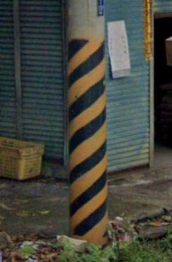
Taiwanese utility poles are everywhere. They are cylindrical in shape and typically have their lower section covered in diagonal black and yellow stripes which stretch all the way to the ground. South Korea also has diagonal black and yellow stripes on their utility poles however in South Korea the black and white stripes don’t reach the ground.
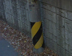
South Korea has diagonal yellow and black stripes on many of its utility poles, much like Taiwan. It also similarly has cylindrical utility poles. Taiwanese stripes mainly stretch all the way to the ground whilst the stripes in South Korea shouldn’t reach the ground. Note: Japan also rarely has South Korean style stripes on their utility poles.

Japan has cylindrical shaped utility poles that occur throughout the country. Japan also has unique yellow and black vertical stripes on many of its poles. On rare occasions, the stripes are diagonal in Japan. In Taiwan and South Korea, they also have the yellow and black markings on some poles however these countries have diagonal stripes, not vertical like the standard Japanese stripes.
The red and white striped arrow pointing downwards indicates that you are in Japan, most likely on the island of Hokkaido or possibly on the island of Honshu near mountains.
Malaysia commonly has these black rectangles with white lettering on their utility poles. These black rectangles only occur on the Malaysian mainland and never on Borneo. Utility poles on Malaysian Borneo are generally slightly thinner than utility poles on mainland Malaysia.
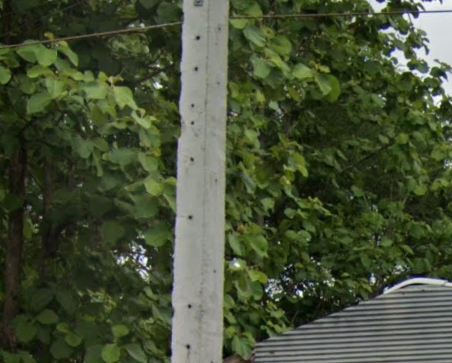
Utility poles in Thailand comes in all shapes and sizes. Fortunately, they can be easily recognised as they virtually all have small holes in them, running vertically. They look like someone has drilled into them. This small hole facet of the poles is rarely seen in utility poles across the rest of the world (they do occur in Belgium).
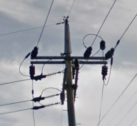
South Korean utility poles stand out as they mainly have what resembles a long, sharp, pointed spike extending upwards from the top of the main pole.

Stobie poles are the utility poles used in the state of South Australia. These poles essentially aren’t used outside of this state. The poles consist of steel on both sides and concrete in the centre.
The Northern Territory in Australia uses these metal utility poles with holes in them.

Approximately 50% of utility poles in the Australian state of Tasmania have these olive metal wrappings around the pole, generally around 2 metres above the ground. These wrappings are often hard to see unless you zoom in as they are a similar colour to the utility pole. These olive colouered wrappings aren’t seen outside of Tasmania.

New Zealand utility poles come in several forms however regardless of form, they mainly have a lone piece of metal (normally silver or white coloured) wrapped around most of the pole.
These concrete utility poles with large holes that go all the way down to the ground are mainly found in Romania and Hungary. In the country specific section further down this article, I’ve posted the primary utility pole from each country.
Romania can often be recognised thanks to their concrete, hollow poles featuring a dash of yellow paint (Hungarian poles sometimes also have a bit of yellow paint too). In addition, a large number of Romanian utility poles are painted with a white base (Ukrainian utility poles sometimes also have a white base).
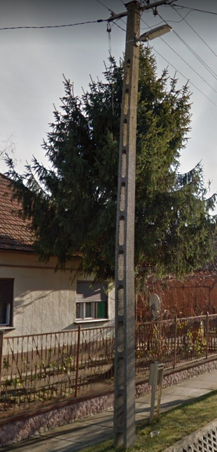
Hungarian utility poles are thinner and narrower than Romanian utility poles.

Poland has concrete utility poles with holes in them. Polish poles are distinct from the utility poles of Hungary and Romania as the holes don’t go all the way to the ground- they stop about half a metre above the ground.

French utility poles can have holes as well however these are often smaller holes.
This is another variant of French utility poles. Spain can have similar utility poles that are white in colour.

France also contains many wooden utility poles (as do many other countries around the world). The French wooden poles are unique as they often feature a blue rectangle on them.

This is the most common type of Belgian utility pole. It is square shaped and contains small holes running up it- much like the Thai utility poles.

This is the second most common type of Belgian utility pole. It contains oval shaped hole section. This pole is also occasionally found in France.

Portugal has two main types of utility poles. The first type is more unique looking and has small holes running vertically up it. Sometimes Portuguese utility poles of this style will have less holes. The second type of Portuguese utility pole is wooden. It often looks fairly rudimentary and can have lumps on its surface.
In Ireland, approximately one third of utility poles have a yellow, triangular ‘danger’ sticker on them. These stickers are sometimes visible in the UK however they tend to be rarer there.

There are a number of types of utility poles used in Lithuania. They mainly have a large number of pine cone looking things pointing upwards near the top of their poles.
Latvian utility poles come in several styles but they often have the ‘pine cone’ looking things that hang upwards at different levels. In the image above, the three ‘pine cone’ looking things are at three different levels.

Estonian utility poles are more likely to resemble a crucifix. Utility poles are one of the best ways to distinguish between the Baltic countries.

A reasonable portion (approximately 25%) of poles in the Baltic countries consist of a pole resting against another pole. This is a much rarer sight across the remainder of Europe.

This concrete cylindrical pole is the most common type of utility pole found in Czechia and Slovakia. It is also found in a number of other places. The Czech and Slovak poles often have several small metal circles going around the pole. They also sometimes have a small white box and a wire running up the pole, as pictured.

Norway, Sweden and Finland (as well as a number of other countries around the world) all use these standard wooden, circular poles.
Many Ukrainian utility poles have their base section painted white (as do many Romanian poles).

Russia typically uses square, concrete poles. These sometimes have a short, horizontal metal bar on top. Several other countries use similar utility poles to Russia, including Ukraine.
Turkey uses a wide range of utility poles. Some of the more recognisable poles are metallic with large holes in them.

Nigeria’s most common utility poles often have a number of indents, like sections have been cut out but not quite enough has been cut out to form holes.

Senegalese utility poles typically have three of these pine cone shaped objects either pointing upwards or downwards.

This is the second type of Senegalese utility pole. Note the pine cone shaped objects pointing down. Also note the indents in the pole, similar to the Nigerian utility poles.
Brazilian utility poles can comes in a range of styles. The most common type is wider at the base and narrower at the top. They also have indents in them. They look similar to Chilean poles however Chilean utility poles have one long indent whilst Brazil typically has 3 indented sections.

Chilean utility poles have one long indent that runs up the pole.
A large number of Peruvian utility poles have part of their lower section painted. There is no single colour they are painted; some are black, blue, yellow, etc or some mixture of colours. Also, some are only painted a few feet up whilst others are painted almost half-way up.

Octagonal shaped utility poles are some of the most common in Mexico and seeing them can be an easy way to identify the country. These poles are rarely seen in other countries however they do sometimes occur in Colombia.
The US and Canada have cylindrical, wooden utility poles- as do many other countries around the world. The US and Canada’s poles sometimes stand out because they can have a singular hook on top of the pole, as pictured (this can be seen in several other countries however it is more common in the US and Canada).

Square utility poles are common in the Dominican Republic.
There is now a folder on my computer named “Distinguishable utility poles from around the world”. What a shameful day for my family if they discover this… I won’t post all the utility poles here- just the most imporant are posted. In the bottom section of this article that lists every country’s identifiable features, I’ve posted these poles.
Bollards
Bollards (that my autocorrect keeps changing to bollocks) are also useful indicators in determining where you are. The bollards listed in this section are the bollards most worth knowing. This is due to their frequency, unique features and/or usefulness in distinguishing one country from another. Additional and more esoteric bollards are mentioned lower down this article in the country specific section.
Although bollards are relatively rare in the UK compared to some other European countries, they are rather unique looking and consist of black and white sections with a large red rectangle on top.
Portugal uses these fairly generic bollards. The front contains a vertical, white rectangle encased in the black section. This helps distinguish the country from Spain. The back of Portuguese bollards feature two white circles in the black section. Similar looking bollards can be found in Luxembourg, Sweden (without the circles on the back) and Latvia (narrower bollards). There is a rarer type of Portuguese bollard that has a fatter orange rectangle in place of the white rectangle.
Spanish bollards are fairly unique. They feature the standard European black and white bollard with a bright yellow rectangle encased in the black section of the bollard.
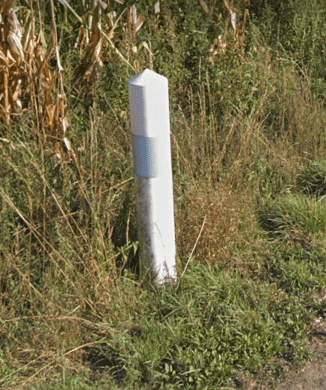
There are two types of French bollard, both are the same distinct shape and different from typical European bollard shapes. This is the first type with a gray reflector strip running around it.

This is the second type of French bollard. It has a red reflector strip running around it. Like the first type of French bollard, it has a unique shape, different from standard European bollards.
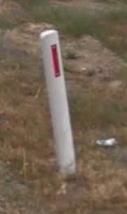
A few types of bollards are visible in the Netherlands. This type is the most commonly seen. Similar looking bollards are found in Turkey and Australia.
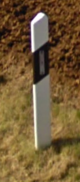
This is the front view of a German and Luxembourg bollard; they look rather generic. The back of the bollards contain two white circles in the white section. Portugal and Sweden have similar bollards to Luxembourg.
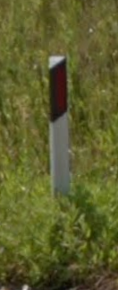
The most common Italian bollard has a front that features a vertical, red rectangle inside a black, diagonal strip. Note that the black part goes to the top of the bollard- this is rare in the bollard world. Albanian bollards look similar however bollards are rare in Albania. The rear of Italian bollards have a white rectangle rather than the red rectangle of the front.

The island of Sardinia (Sardegna) has similar bollards to mainland Italy however the rectangle is orange in colour.

This is the type of bollard found in Sicily. Note the rectangle’s width and the fact that it can be orange or red in colour.

Albania has the same looking bollards at Italy featuring a red rectangle in the black section of the bollard that extends to the top. Bollards are fairly rare to see in Albania compared to Italy. Albanian bollards have a white rectangle on their rear.

Finnish bollards are either cylindrical or look cylindrical from the front. This cylindrical shape isn’t shared by the bollards of the other Nordic countries. Otherwise, Finnish bollards look like fairly generic, black and white, European bollards. Finnish bollards look similar to Estonian bollards.
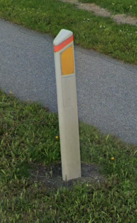
This is what the front of bollards in Denmark look like. They are a unique looking bollard and occur abundantly throughout the country. The rear of the bollard lacks the yellow section.
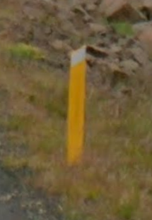
These distinctive yellow bollards are visible right across Iceland.

The reflectors on the front of Austrian bollards are either blackish or dark red in colour. Seeing this black reflector and the black hat on the bollard is one of the easiest ways to tell that you are in Austria. No other countries have both of these features on their bollards. Slovenian and Montenegrin bollards look similar however they have a bright red rectangle.

Swiss bollards are often this curved-cylindrical shape. This is the front of the bollard. The back of the bollard features two white dots in the black section.

Polish bollards have a red diagonal stripe wrapping around the bollard.
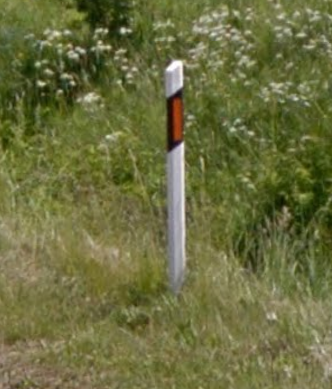
This is what the front of Lithuanian bollards look like- they have a white rectangle on the rear instead of orange. These plastic bollards (that look like wood) with an orange rectangle are one of the best ways to distinguish Lithuania from the other Baltic countries (and other European countries). Latvia and Estonia both have bollards with a white rectangle on the front and white dots on the back. Bollards are found every few metres on well-frequented roads in Lithuania. The Lithuanian bollards are thinner than typical plank bollards.
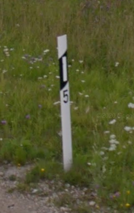
The most common type of Latvian bollard is a thin plank with a generic white rectangle on the front. The rear of the most common type of Latvian bollard has two white circles.
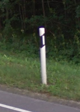
Standard Estonian bollards are cylindrical. This contrasts the narrow plank bollards of Lithuania and Latvia. The front of Estonian bollards have the white rectangle encased in the black section, similar to the Latvian bollards. Estonian bollards will on rare occasions have a yellow rectangle rather than the white rectangle. Estonian bollards have two white circles on their rear. Estonian bollards look similar to Finnish bollards.

The is a Czech and Slovakian bollard. Both Czech and Slovakian bollards have these unique fluro orange stripes in the black section of the bollard. The back of Czech and Slovakian bollards have a white rectangle in the black section.
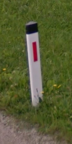
This is the front view of Slovenian and Montenegrin bollards. Serbia also have similar looking bollards- albeit with the red rectangle far to one side. Slovenian and Montenegrin bollards look like many Austrian bollards however Austria has a black or darker (blacker) reddish rectangle.

This is the front view of Hungarian, Bulgarian, Croatian and North Macedonian bollards. These countries also share the same white (rather than red, like the front) rectangle on the back of their bollards.

This is the main type of Serbian bollard. It resembles the bollards of Slovenia and Montenegro however the difference is that the Serbian red rectangle is always to one side- not in the centre.

This is the rarer version of Serbian bollards. Note that the red rectangle is also to one side. The rear of the bollard has a white rectangle. Bulgaria, Croatia, Hungary and North Macedonia have similar looking bollards but instead have the red rectangle centred.

This is the most common type of Ukrainian bollard. It has a red rectangle that is wider than the rectangles of Hungary, Bulgarian, Croatia and North Macedonia. Ukrainian bollards look like Russian bollards however Russian bollards are attached to a narrow support pole. Ukrainian bollards are typically run-down with the rectangle often damaged.

This is a Russian bollard. Russian bollards often have a unique feature- a narrow support pole on one side of them. This makes them unique from Ukrainian bollards. Russian bollards are primarily found at intersections.
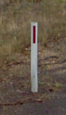
The first type of bollard in Australia features a red rectangle. This bollard looks similar to bollards in Turkey and the Netherlands.

The second type of Australian bollard features a red circle.
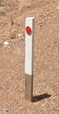
Rural bollards in the state of Western Australia often have these brown/gray segments on their base.
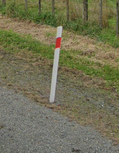
New Zealand has unique bollards lining their highways that have a red/orange strip that stretches around the higher part of the bollard.

These narrow, red and white signs are in some ways the bollard equivalent in South Africa. They are very common.

The front and back view of Japanese bollards.
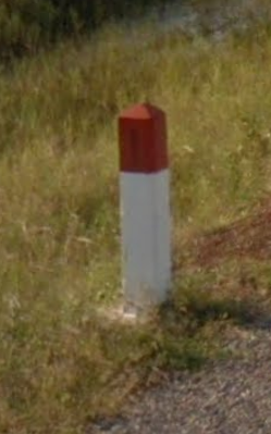
Cambodian bollards look a bit like fat matches. They have a white body and red head.
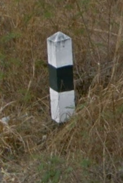
Thai bollards have an obelisk shape. They have alternating black and white sections.
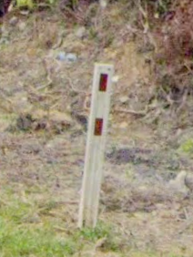
Malaysian bollards have two red rectangles on them. Some bollards have two gray rectangles on one side.

Kyrgyzstan has bollards painted white with a black section. They look like thick planks of wood.
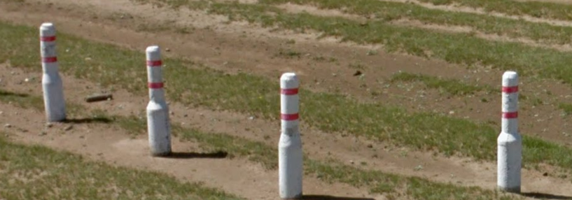
Mongolian bollards remind me of the pins from ten-pin bowling. Sometimes they lack the stripes and are just white.
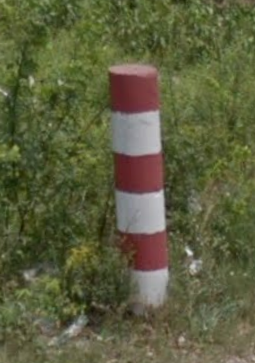
Bangladeshi bollards look like chimneys and are painted in alternating red and white sections. Sometimes the bollards are shorter than this image and thus have less red and white sections.
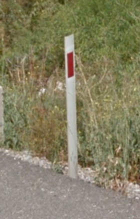
These bollards are a common sight throughout Turkey and resemble the Australian and Netherlands bollards however they have a slightly fatter rectangle in Turkey.
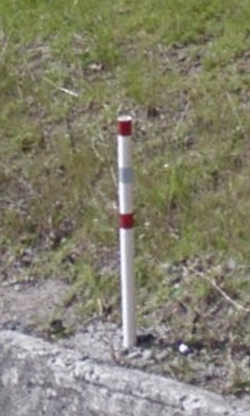
Ecuador has a number of different shaped bollards. The type pictured is the most common- featuring two red stripes. Another Ecuadorian bollard contains just one red stripe.

Peru’s most common bollards look like cigarettes. They sometimes have the black stripes pictured here but on other occasions they lack these black stripes.

Mexican bollards are white and cigarette shaped. They have a black section on the base of the bollard or near the base.
A Google Spreadsheet document showing the bollards used in every country can be viewed here. It was created by Mahbows on reddit. In the country specific section of this article, further down, more esoteric bollards are described.
Flags
There are many state and national flags flying around the world that serendipitously pop up in GeoGuessr. Being aware of the flags of the world (or at least flags of GeoGuessr countries) is vitally important. The national colours of countries also make frequent appearances on Street View. These appearances can include anything from the colours of chairs, colours of signs to writing on advertisements. For instance, if you know you are in Europe and spot a red, white and green setup of chairs then you may be in Italy, Bulgaria or Hungary.

Flags of Europe. (Source for all flag- world map images is Transparent 6lue, Wikipedia)

Flags of North America

Flags of South America

Flags of Asia

Flags of Africa and a bit of the Middle East
Being aware of the USA state flags can also be of importance in GeoGuessr as these are often visible. Below is a map featuring these state flags:

USA state flags. (Source: SiBr4, Wikipedia)
Flag Trick (Battle Royale)
If you are engaging in an epic Battle Royale mode GeoGuessr skirmish to the death, there are some unscrupulous techniques some players use to reign victorious. Think of it as kicking someone in the nether regions whilst in a fight- it’s a frowned upon, cheap trick. The incorrectly guessed Battle Royale countries are denoted by flags in the top-right corner of the screen. Before making your guess, you will likely check the flags to ensure you don’t guess an already deemed incorrect country.
What certain countries lack in creative flag designs is sometimes exploited by GeoGuessr players. For example, if a player is certain they are in Ireland, they may select the Ivory Coast on their first guess. The flags are so similar, many of the other players will be confused and thus avoid guessing the correct country of Ireland. Although this is a real jerk move that ostracizes the flag-trickster from other players and is tantamount to cheating… normally these sentences end in a positive. I’ve thought of one- people may be forced to brush up on their flag knowledge.
I only mention the ambiguous flags trick in order for players reading this article to be aware that other players (not me) may try this dirty trick (once again not me). It’s important to be cognizant of these other dodgy characters (not me) playing GeoGuessr who are fixated on winning at all costs (once again, I emphasise- not me). The ambiguous flags are listed below.
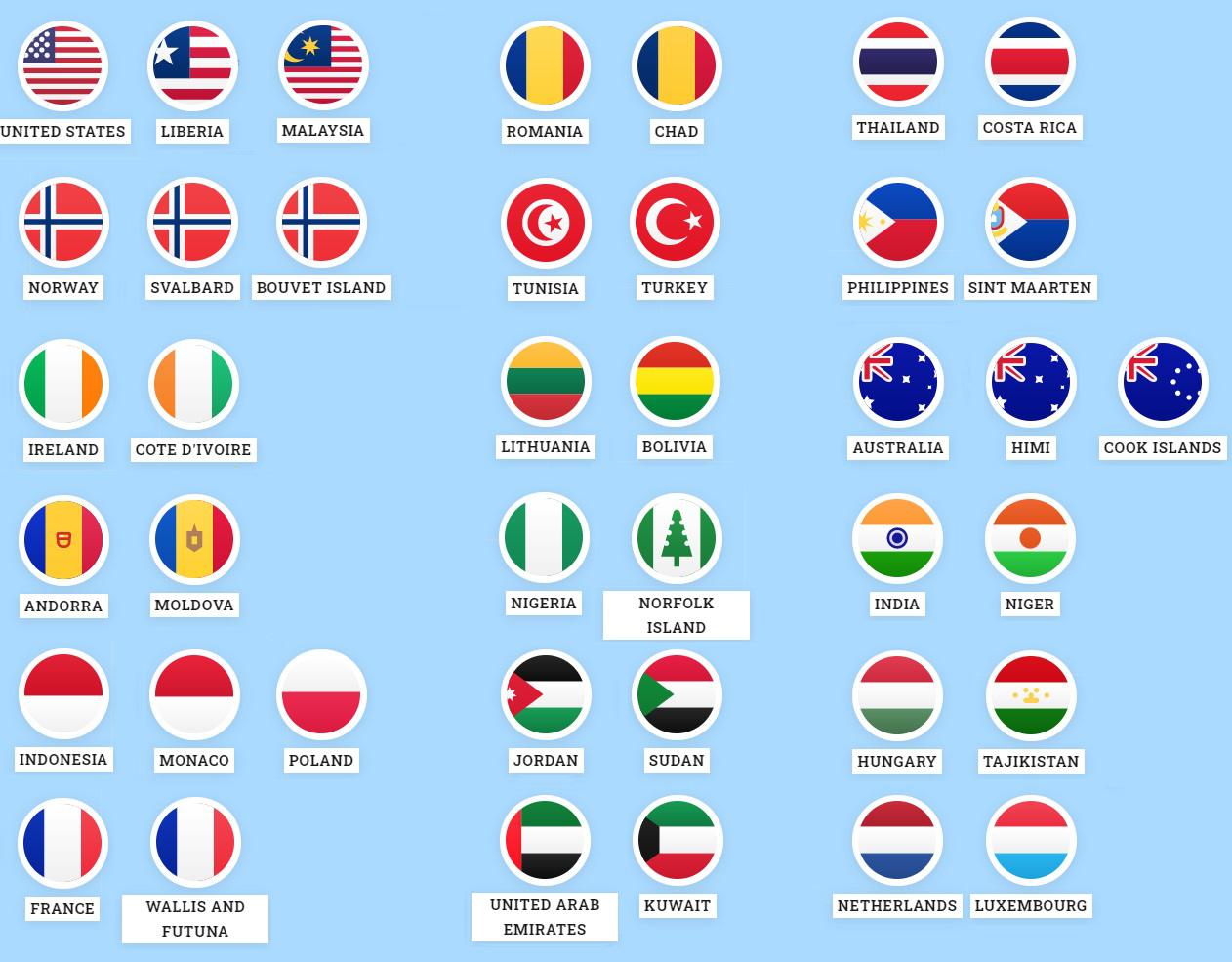
The above flags are similar enough that you may be able to trick opponents in Battle Royale. For example, if you are located in Romania, you can guess Chad. The Chad flag will then be displayed in the list of incorrect guesses. The other players will likely think that Romania has been ruled out (due to the similar looking flags) and hence avoid guessing Romania. (Source: Gilabend, Reddit).
Internet Domain Name Suffixes
Another useful clue in the game is finding internet suffixes on buildings or signs. The letters after .com. indicate the country of the domain name. For instance www.google.com.au means you are in Australia with the AU suffix. Some suffixes of note that are conspicuous for their letters not matching the country’s name in English or not being 100% clear are: .at= Austria, .ch= Switzerland, .de= Germany, .ee= Estonia, .es= Spain, .hr= Croatia, .ie= Ireland, .is= Iceland, .sz= Eswatini.ua= Ukraine and .za= South Africa.
Below are all of the internet domain name suffixes for the GeoGuessr relevant countries. The list is in alphabetical order according to the domain name suffixes.
.ad = Andorra
.ae = United Arab Emirates
.al = Albania
.ar = Argentina
.as = American Samoa
.at = Austria
.au = Australia
.bd = Bangladesh
.be = Belgium
.bg = Bulgaria
.bo = Bolivia
.br = Brazil
.bt = Bhutan
.bw = Botswana
.ca = Canada
.ch = Switzerland
.cl = Chile
.co = Colombia
.cr = Costa Rica
.cz = Czechia
.de = Germany
.dk = Denmark
.do = Dominican Republic
.ec = Ecuador
.ee = Estonia
.es = Spain
.fi = Finland
.fo = Faroe Islands
.fr = France
.gb = Great Britain
.gh = Ghana
.gi = Gibraltar
.gl = Greenland
.gr = Greece
.gt = Guatemala
.gu = Guam
.hk = Hong Kong
.hr = Croatia
.hu = Hungary
.id = Indonesia
.ie = Ireland
.il = Israel
.im = Isle of Man
.in = India
.is = Iceland
.it = Italy
.je = Jersey
.jo = Jordan
.jp = Japan
.ke = Kenya
.kg = Kyrgyzstan
.kh = Cambodia
.kr = South Korea
.kw = Kuwait
.la = Laos
.lb = Lebanon
.lk = Sri Lanka
.ls = Lesotho
.lt = Lithuania
.lu = Luxembourg
.lv = Latvia
.mc = Monaco
.me = Montenegro
.mg = Madagascar
.mk = North Macedonia
.mn = Mongolia
.mo = Macau
.mp = Northern Mariana Islands
.mt = Malta
.mx = Mexico
.my = Malaysia
.ng = Nigeria
.nl = The Netherlands
.no = Norway
.nz = New Zealand
.pe = Peru
.ph = The Philippines
.pl = Poland
.pr = Puerto Rico
.ps = Palestine
.pt = Portugal
.re = Reunion
.ro = Romania
.rs = Serbia
.ru = Russia
.se = Sweden
.sg = Singapore
.si = Slovenia
.sj = Svalbard & Jan Mayen Islands
.sk = Slovakia
.sm = San Marino
.sn = Senegal
.sz = Eswatini
.th = Thailand
.tn = Tunisia
.tr = Turkey
.tw = Taiwan
.ua = Ukraine
.ug = Uganda
.uk = UK
.um = United States Minor Outlying Islands
.us = The United States of America
.uy = Uruguay
.va = Vatican City
.vi = US Virgin Islands
.vn = Vietnam
.za = South Africa
Other clues
Richer countries are more likely to have better maintained roads and thus you can use this information to include or exclude certain countries from your calculations. Also the general levels of poverty are worth noting. If you spot any people in GeoGuessr then use their appearance to match up to a mental list of possible countries of origin.
As you zoom into a city on the map, the name of the city written on the map is typically where the centre of the city is.
It is generally possible to use ratios to determine where you are if you see distances to towns that you can locate on the map- see the images below.

If you notice a distance sign to towns, it is generally possible to get a fairly accurate idea of where you are positioned using ratios. Firstly, locate some of the towns on the map. In this example, I would look for Crafers (7km away) and Bridgewater (14km away). I would then look at the general direction that the road is travelling beyond the sign (in this case, east). Finally, I would work out the ratio of the locations. In this example, Crafers is located half-way between my current location and Bridgewater. I would then look at the map (below).
Using ratios, I would place my fingers over the map and measure the approximately distance between Bridgewater and Crafers and extrapolate that again, thus working out my approximate location. When ratios are more complicated, eg once location is 17km away and another is 104km away, I would round the numbers off to 20km and 100km. I would then determine that there are 4x20km sections between the towns (1/4 of the distance) and that is the approximate distance between me and the closest location.
Photospheres are locations in GeoGuessr that haven’t been captured by the Google Street View car but rather a real humanoid (apparently they exist). These locations often appear at monuments, attractions or indoors e.g. at shops. Some of my favourite aesthetically pleasing GeoGuessr locations have been at photospheres of lakes. Often these human captured photospheres mean that you can’t move.
There are a few tips to be aware of if you encounter a photosphere. Firstly, you can tell that it is indeed a photosphere because the photographer’s name appears in the bottom right corner of the picture (as opposed to the words ‘Google’ and a year). This provides a big clue into the location of the photosphere. Try working out the language origin of the photographer’s name. If they aren’t on vacation, then you are well set to make your guess. For instance, the photosphere below has the photographer’s name: Casper Van Hooren. This tells us that he is likely Dutch and thus we are likely in the Netherlands (we are actually in New York so this was probably a bad example). It also tells us that he either legally changed his name to Casper to honour the 90s movie ghost franchise or Casper is his real name. On the whole, photosphere locations are typically places not covered by Google Street View and thus they are places that don’t regularly pop up on GeoGuessr. India seems to have a high proportion of all photosphere locations.

In the bottom right corner of this photosphere appears the name ‘Casper Van Hooren’. Analysing the name’s origins can be useful in determining the photosphere location.
Look at these nice round numbers: 1 mile equals 1,760 yards or 5,280 feet or 63,360 inches. In contrast, look at these arbitrarily and hodgepodge numbers: 1 kilometre equals 1000 metres or 100,000cm. For some reason only the sensible USA, UK and the might of Liberia and Myanmar use miles (Liberia and Myanmar aren’t in GeoGuessr- perhaps as part of some grand conspiracy theory involving using miles). In contrast, every other country on earth uses kilometres. When will the other countries catch up to these four avant-garde areas? Nonetheless, signs on Street View often denote speed limits or distances using kilometres or miles. If you see miles, then you are probably in the USA or UK. This technique is especially useful for distinguishing Canada from the USA.
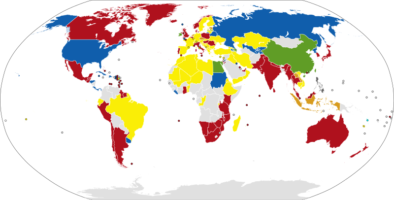
The colour of post boxes around the world. I find this most useful in distinguishing Canada (red post boxes) from the USA (blue post boxes). A larger image can be viewed here: https://upload.wikimedia.org/wikipedia/commons/b/b0/Map_of_colours_of_post_boxes.svg Source: NuclearVacuum, Wikipedia.

By looking at the soil colour alone, it is possible to make surprisingly accurate guesses. For example, the Brazilian state of Goias has reddish soil, which contrasts the soil colour across most of South America. Playing the potentially unintentionally pun-named map ‘A Soiled World’, you can improve your soil expertise: Play NMPZ- https://www.geoguessr.com/maps/607d8ba950996a00015439cc
A map of chevron designs around the world. Chevron are signs with arrows on them that generally indicate a corner on a road. (Source: Bullfrogggy) A larger version of this map can be seen here.

A map showing what style of stop sign is used around the world. A larger version of this map can be viewed here. Thanks to whoever made this map.
A map showing deserts around the world. Note that the orange colour on the map indicates a semi-desert which is somewhere that receives a low amount of rainfall but not as little as a desert. (Source: https://www.kids-world-travel-guide.com/)
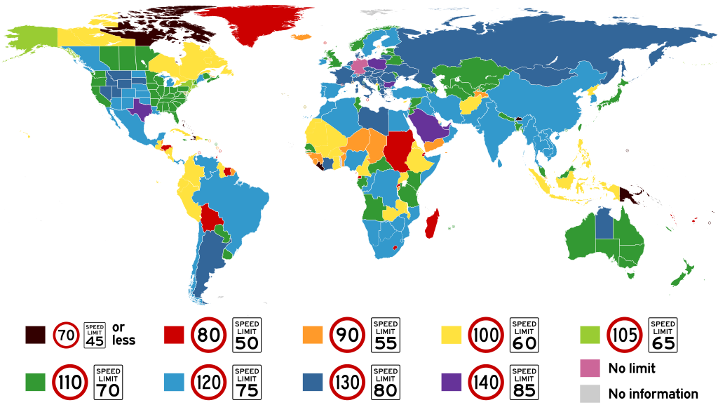
A map indicating the maximum speed limit by region. The key shows both km/h within the red circle and miles/h written on the black and white sign. (Source: Amateria1121, Wikipedia) Note that NZ has a maximum speed limit for most of the country of 100km/h (only two of its roads have a limit of 110km/h). A larger map can be viewed here.

Most major cities have distinctive street signs. Whilst some of the more notable unique street signs are mentioned in this article, there are hundreds that are worth knowing. Militantcyclist has created this amazing 45 page long document that shows the unique street signs by major cities across the world.

In countries or areas with few main roads, it is important to look at the road orientation before you guess. This is particularly true in areas including Patagonia, Botswana, Mongolia, Jordan and outback Australia. As there are so few major roads in these areas that you can be on, by looking at the road orientation, there is a high chance you can guess the precise road you are situated on. Firstly, pan down so you are facing the road directly, secondly, orientate your position so the compass is facing north and finally, look for roads on the map that run in the same direction as your road.
If you are situated in a remote area, unsure of which direction to travel, then it may be worth keeping an eye out for tyre marks stemming from any driveways- do they turn left or right?. These tyre marks will likely lead in the direction towards civilisation. Another trick in remote areas is to determine which direction the Street View car came from. This is more likely to be a main road than the direction it is heading. If you can’t determine the direction the Street View car came from, you may be able to look for dirt that the car has stirred up, which will be at its rear.
If you are in a remote area, there are a number of clues you can use to determine the best direction to travel to reach civilisation. One clue is to look for dirt tracks stemming from driveways. These will generally head towards civilisation. In the above image, the dirt tracks lead to the far side of the road, and cars drive on the left in this country, therefore, civilisation is likely to the left. If there are no clues on which direction to travel in a remote area, it may be worth travelling in the direction the Street View car came from as it more likely that the car came from a major road than it is heading towards one. Travelling downhill is also generally a good idea.
Meta
Street View Car Hints
Certain events have occurred in the historical competitive arena that aren’t in the “spirit of the game”. These include Australia’s Trevor Chappell rolling a cricket ball along the pitch to a New Zealand batsman who couldn’t get under the ball to hit it over the fence. Another such incident occurred in a Major League Baseball game in which the St. Louis Browns signed up a player with dwarfism, Eddie Gaedel, who stood 3 feet 7 inches high to bat for their team. His strike zone was so small, the pitcher couldn’t pitch into this area and he walked to first base. This not in the “spirit of the game” conundrum hits GeoGuessr too. This comes in the form of various, different looking Street View cars being visible and a range of cameras being used helping lead to country identification.
In a handful of countries, if you pan down to look at the ground under the car, the Street View car you are driving in has 4 ends of bars that protrude from the car. The countries these bars are almost certainly visible in are: Guatemala, the Faroe Islands, Mongolia, Kyrgyzstan, Senegal, Ghana and Kenya. Curaçao, a Dutch, Caribbean island, also has bars visible. Some further countries also have the 4 bars visible but only in certain regions of their country, such as Bangladesh and Nigeria. Also the couple of small towns in Laos that are covered by Street View outside of Vientiane will have bars. Many players use this knowledge to their benefit whilst playing GeoGuessr despite these metal bars not being a fixture of the environment. Being a more honest player, I accidentally bang my arm causing a reflex action that results in my right hand fingers serendipitously parting and hitting the laptop touchpad and click button simultaneously resulting in the GeoGuessr view panning down to reveal bars or no bars on the Street View car.

If you pan down in certain countries, the bars protruding from the Street View car are visible. This occurs in: Guatemala, the Faroe Islands, Mongolia, Kyrgyzstan, Senegal, Ghana, Kenya, the Dominican Republic, the US Virgin Islands and Curaçao. Parts of Bangladesh, parts of Nigeria and parts of Laos also have the bars visible.
Ghana has black pieces of tape around one of the four bars.
Ghana can be recognised as it has a piece of black coloured tape around one of its four bars.
The Kenyan Street View car also sometimes has this black protrusion protruding from the front left corner of the car. This is often visible without having to pan down.

Kenya sometimes has the bars visible as well as a black ‘snorkel’ at the front of the Street View car. Seeing this snorkel indicates that you are in Kenya.
In Uganda, the sides of the Street View car are visible. This isn’t true in the small sections of Ugandan National Parks that occur in GeoGuessr. Ugandan Street View coverage is centred around Kampala.

The white edges of the Street View car and the black, side view mirrors can easily be seen in Uganda.
Mongolia can be recognised thanks to the bars appearing underneath the car in tandem with either red coloured side mirrors or something resembling camping equipment under the car. Kyrgyzstan has the bars underneath the car with only black/white coloured side mirrors.
This ‘camping equipment’ look is often found under the Street View car in Mongolia along with the bars.
The rear side mirrors are an alternate option to the ‘camping equipment’ view and also indicate Mongolia.
Kyrgyzstan has the bars under the car visible as well as black/white side mirrors.

Guatemala has the bars visible as well as the black mirrors.
There are a number of countries that have a transparent, ghostly, floating part of the Street View car visible. In Argentina this floating, ghostly part of the car is the front part of the Street View and is almost always black. In newer coverage it appears white in Argentina however this is rare. For most purposes, black ghost car= Argentina. Uruguay also typically has the black car. These countries stand out from the rest of the Americas which largely have a white car although Peru and Colombia sometimes have the black car.
The front of the Street View car is normally this ghostly, black colour in Argentina and Uruguay. Occasionally, in updated coverage it will appear white but this is rare. Across the Americas, this black car is rare although you will sometimes see it in Peru.
Much of the South Americas can have the back of their ghostly car as white coloured or perhaps this is the first indisputable proof caught on camera that ghosts are real. I tend to note it most commonly in Peru, Bolivia and Colombia.
The back of the Street View car appears white in much of South America. I tend to see a floating white section of the car (like the one pictured above) most commonly in Peru, Bolivia and Colombia.
Ecuador can typically be recognised thanks to the car having a short antenna. This can often be hard to see so don’t think you will fail an eye-test if you can’t always see it.
If you pan down, Ecuador has a short antenna under the back of the car. Sometimes it can be challenging to see.
Large parts of Chile can be recognised thanks to something resembling a white vacuum cleaner that is actually the back of the Street View car.

The majority of Chile can be recognised thanks to the white rear of the Street View car being visible.
The southern African countries of South Africa, Lesotho, Eswatini and Botswana almost always have the white Street View car visible. The remainder of Africa largely doesn’t.

South Africa, Lesotho, Eswatini and Botswana should have the white car as visible. This contrasts the rest of Africa in which the white car generally can’t be seen. In South Africa, you will see the white car or a large, blurred circle under the car.

Pictured above is the Kenyan car that took the new coverage. The car sometimes lacks the snorkel and/or antenna or has a double antenna. The alternative Kenyan car has bars and a snorkel (pictured further up this meta section).

This is the Rwandan car (which is more of a black truck).

This car (or a variant of it) took most of the new Nigerian coverage. The old Nigerian coverage is still on Street View and includes black and yellow bars beneath you and a large blur.

Parts of the new Senegal coverage was taken with this white truck. The old coverage is still on Street View and consists of standard bars beneath you when you pan down.
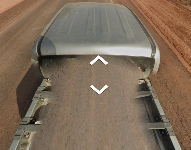
The remainder of the new Senegal coverage was taken with this silver truck.
If you pan down, most of Ukraine has a red car with a long antenna, visible. This can be particularly useful if you are pondering whether you are in Ukraine or Russia.
Most of Ukraine has a red car with a long antenna.
The majority of Russia has a ghostly, black car visible as well as an aerial.

If you pan down in most of Russia, you should see some semblance of a black car with a long aerial.
Norway and Denmark typically have a blue Street View car that is normally only visible if you look rather carefully. On some occasions, the blue is so faint that by recognising it, you would be worthy of being on one of those ‘Superhuman’ TV shows.
If you pan down in Norway and Denmark, you should see a very faint blue Street View car. Sometimes it can be hard to tell that it is indeed blue unless you possess superhuman abilities or are of a different species.
Vietnam is easily recognisable thanks to the Street View coverage being recorded on a motorbike. So you need to pan down and you will see the motorbike or blurred outline of one. Now jump on one leg and spin around. Now stop following my instructions.
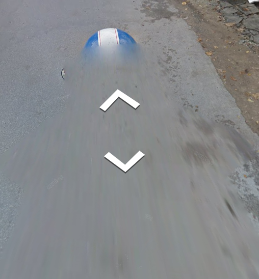
Street View coverage in Vietnam was recorded on a motorbike. In Vietnam you will either see the motorbike, the blurred outline of the motorbike or a helmet.
Limited Qatar coverage was taken in this white truck.

This white car is used in the Qatari coverage (although it may appear blurred). It looks similar to the white Senegal car; however, the Qatari car has a narrow antenna on the far-left. In contrast, the white Senegal car has s stubbier, black antenna on the front-centre.
Distinguishing between Jordan and the United Arab Emirates can be challenging on landscape alone. If you pan down in Jordan, you will see a black car whilst if you pan down in the UAE, you will see a white car.

A black car is visible if you pan down in Jordan.

If you pan down in the United Arab Emirates, you will see a white car or truck. This can be a good way to distinguish the country from Jordan which has a black car.
Kazakhstan is famous for many things, including Borat and the white truck that captured the entire country’s Street View.
Kazakhstan can be easy to identify thanks to this white truck that captured the entire country’s Street View imagery.
The Dominican Republic is recognisable thanks to the bars on the Street View car containing thick, centred, black, parallel lines. The Dominican Republic car is also especially long.
These bars with thick black lines indicate that you are in the Dominican Republic or Mongolia.

If you pan down in the US Virgin Islands, you will see a bulky ute (pick-up truck) that has the bars visible and a tray in the rear. The vehicle will be white on the two northerly islands and either red or white and lacking the black antenna holder on the main southern island.
Japan and Switzerland’s Street View car is recognisable thanks to two reasons- 1. If you can see some semblance of its shape, it appears wider than the normal Street View car. 2. The cameras are lower to the ground. Rarely this low camera is also used in Taiwan and Sri Lanka.
The Japanese and Swiss Street View car appears wider than the normal Street View car. Rarely the Taiwanese car will also appear wide.
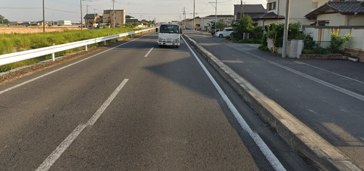
Japan and Switzerland both have a lower than normal camera positioning on their Street View cars. This means you will feel lower to the ground when you look around Japan and Switzerland. Rarely Taiwan and Sri Lanka also uses the low camera.
Sri Lanka is easy to recognise due to its Street View car resembling the French flag- blue, white and red stripes.
Sri Lanka’s Street View car has blue, white and red stripes, resembling the French flag.

In the Philippines, you should generally see some sort of white outline of the edge of the Street View car.

Across almost all of Eastern Europe, the Street View car’s aerial is visible. It is also visible in a number of other places in the world.
North Macedonia and Serbia are the two countries in the Balkan region (and largely Eastern Europe region) where you shouldn’t see the Street View car’s aerial. There are instances where you will see an aerial but it is rare. The rest of Eastern Europe typically has the aerial visible (although on occasions it won’t be).

In Bulgaria, Hungary, Slovakia, Romania, and Czechia, you will sometimes see tape on the Street View car’s antenna.

In Israel, you should often see the Street View car’s long aerial.
Alok has produced the goods and created an excellent map indicated the colour/type of Street View car visible in certain countries around the world. This can be valuable information when it comes to determining where you are located.

This map indicates what you are likely to see when you pan down to look at the Street View car. (Source: Thanks to Alok for producing this brilliant map!) A larger version of this map can be viewed here.
This article just covers the primary visible cars you will encounter in GeoGuessr. If I included all of the unique cars e.g. for tiny island territories, this article would be so long, it would stretch beyond the observable universe. This document by Winston Qin lists all of the cars you will observe via country or territory.
This document, also by the prolific Winston Qin, is close to the length of the observable universe. It describes every type of distinct car/form of transport for the Google camera that can be seen across the globe, by region.
If you wish to play GeoGuessr the way it was intended, without an unnaturally occurring car beneath you, there is a script you can use to place a giant blob over the Google Street View car. This can be found here.
Rifts
If you pan up in Senegal, you should see a few things. The first of these is a majestic sky (sometimes covered in clouds), that obscures the vastness of the mysterious universe. You will also sometimes see giant lines- a remnant of the Street View images being morphed together. Which of these two things is more awe-inspiring is debatable.
If you pan up in Senegal, you will sometimes see giant rifts in the sky.
You should also see the giant rifts across almost all (but not quite all) of Montenegro. I have made a map documenting where you will and won’t see the rift in Montenegro.
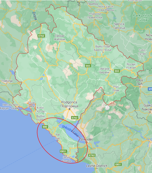
Everywhere approximately outside the red oval, you will see rifts in Montenegro. Within the red oval, the sky should appear normal.
Albania also has rifts in seemingly random positions throughout the country. Other than Senegal, Montenegro and Albania, you shouldn’t generally see rifts in the sky other than for very minuscule areas of some countries. These include: Portugal, UAE, Croatia, Serbia, Uruguay and the state of Oaxaca in Mexico. Once again, these latter areas generally won’t have rifts except for the rarest locations.

Albania has rifts in some parts of the country. Montenegro has rifts across almost all of the country.
The Escort Car
There are three countries in GeoGuessr that can have a 4-wheel drive/SUV following the Street View car. If you feel paranoid in these countries and come to develop the belief that you are being followed- then you are right to be paranoid. You are being followed. What is technically happening is that you are being given a private escort (of the car variety) throughout these countries. In some of Nigeria, almost all of Tunisia and large parts of Kenya, the car will be following you. Sometimes it will be a few metres behind you, on other occasions it will be up to 100 metres behind you. On rare occasions it will be in front of you.
Across some of Nigeria, a 4-wheel drive escort follows the Street View car. This 4-wheel drive is silver coloured in greater Lagos. If you are followed by a white pick-up truck with police lights you are outside of Lagos. A black 4-wheel drive follows the Street View car in two small areas in Nigeria: Benin City and the E1 south of Logbara. The full details of this following car’s colour in specific, Nigerian areas are in the Nigeria section further down this article.

This dark green Mazda follows the Street View car in almost all of the Tunisian Street View coverage (note the red and black license plate). There is a map situated in the front- centre of this car’s window in Sfax and Gabes. There are some small parts of the country that the dark green Mazda doesn’t follow the Street View car. A darker green Toyota follows the Street View car in Tunis.
Some of the time in Kenya, you will see a 4-wheel drive following you that is providing an escort to the Street View car. The car can come in different colours. Sometimes the car will be 100 metres behind you.
In Alaska they double-booked the Street View car. They didn’t follow the 4 Seasons Total Landscaping methodology of getting out of double-booking so both cars drove around parts of Alaska. In Alaska you will sometimes see another Street View car down the road from you with an elevated camera on top.

In some parts of Alaska you will see another Street View car down the road from you will an elevated camera on top.
Camera Generations
Earlier in this article I mentioned the hotspot locations for really blurry Street View locations (parts of the US, Australia and New Zealand). These were taken with the generation 1 Street View camera. If you encounter a generation 1 camera with poor image quality, the goal should be to reach a more major road than you are currently on; this will hopefully mean more crystal clear images.
There is another clue that can be used when it comes to the Street View camera’s quality of images. Certain generations of Street View camera are used in specific countries. By identifying the camera used (from generation 1 to 4), you can sometimes narrow down you location.
The generation 2 camera sometimes shows up when it produces a halo (not the game) around the sun as seen below. Other features of this camera involve brighter colours and slightly worse picture quality than the typical Street View images (but nothing like the really blurry, generation 1 images). The generation 2 images also lack a visible aerial on the Street View car. If you notice this camera has been used by seeing a halo around the sun or spotting the camera’s other features then you can narrow down the country you are in.
This generation 2 camera is used in large parts of Mexico and is useful for distinguishing this country from the USA in which the generation 2 camera has seldom been used. The generation 2 camera is also used in large parts of Australia, New Zealand, Greece, Italy, Portugal and Spain. Additionally Canada, Norway and Finland also have many locations covered by this camera. If you are in the southern part of mainland Africa and note the generation 2 camera then you must be in South Africa as Botswana, Eswatini and Lesotho don’t use generation 2. South Africa also uses generation 3. Google will eventually update images in all of these countries so this information will eventually be out-of-date. A Google docs spreadsheet created by Alok details which of the four generations of Street View cameras (or which combination) are used in each country. He also created the map that can be viewed below. Both the spreadsheet and larger version of the map can be viewed here.

A map indicating which generations of Street View camera are used in each GeoGuessr relevant country in the world. (Source: Many thanks to Alok for creating this amazing map). A larger version of this map can be viewed here

The generation 1 camera is of ridiculously poor quality and is easy to spot. If you encounter it, you must be in the US, Australia or New Zealand.

The generation 2 camera produces bright colours and slightly inferior image quality relative to the generation 3 and 4 cameras.

The generation 2 Street View camera often produces a halo around the sun, shows images as bright and is of slightly worse image quality than the subsequent cameras. If you recognise that this generation 2 camera has been used, you can narrow down the country you are in.

The generation 2 camera also tends to produce a circular blur beneath the Street View car.
The generation 3 camera is the most commonly used in Street View. It produces good quality images. Identifying this camera is rarely useful as it is so ubiquitous.
The generation 4 camera produces more vivid colours and has a higher quality image than generation 3. Identifying this camera can prove useful as it is not used in large parts of the world (see the above map).

The generation 4 camera often produces a ghostly, blue car if you pan down.
If can often be difficult to distinguish between the generation 3 and 4 cameras and it takes practice. This information can prove useful if you are aware of the above map.

If you notice the generation 2 camera has been used in southern Africa, (and you are considering Lesotho, Eswatini, Botswana and South Africa, then you must be in South Africa, as these other countries don’t use the generation 2 camera.

Across the entire German coverage, the generation 2 camera is used.

If you are tossing up between the USA and Mexico and notice the generation 2 camera has been used then you are likely in Mexico as the USA generally doesn’t use this camera much.
Large parts of Europe around the Mediterranean use the generation 2 camera.
The generation 2 camera is predominantly used in a number of small countries or regions. These include: Monaco, San Marino, the Isle of Man, Jersey and Macau.
If you are in Latin America and notice the generation 4 camera has been used/you see a blue car then you are in Mexico, Brazil or occasionally Argentina. The other Latin American countries don’t use the generation 4 camera/have a blue car. Mexico, Brazil and Argentina also use other generation cameras in tandem with the generation 4 camera.

A map showing the distribution of generation 1 coverage. Note: Japan no longer has any generation 1 coverage. A larger version of this map can be viewed here. Image source: I don’t know who created these 4 maps but thank you whoever you are!

A map showing the distribution of generation 2 coverage. A larger version of this map can be viewed here.

A map showing the distribution of generation 3 coverage. A larger version of this map can be viewed here.

A map showing the distribution of generation 4 coverage. Note that Switzerland also recently got some generation 4 coverage. A larger version of this map can be viewed here.
License Plates
- European Plates
- USA Plates
- Canadian Plates
- Australian License Plates
- Asian License Plates
- African License Plates
- South American License Plates
- European License Plate Extras
- Russian License Plate Extras
- USA License Plate Extras
- Canadian License Plate Extras
The Colour of Blurred License Plates
One of the first things I do when facing a location in GeoGuessr is to breathe. After breathing has been established I try and find a license plate. Despite the blurring, the colour of plates is still visible and sometimes the colour of the lettering or a design is also vivid.
If a country isn’t mentioned here, it is not because they have rampant crime due to not using license plates. Rather, they likely use white, non-descript plates that are useless (for GeoGuessr purposes).
European Plates
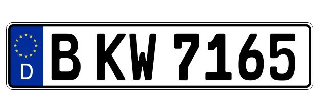
The blue stripe on the left of the license plate is visible despite the blurring in GeoGuessr and indicates a European location.
Most of Europe have long license plates with a blue vertical stripe on the left end. These plates are clearly visible in GeoGuessr. Only several European countries have yellow license plates which are easy to identify besides the blurring: the Netherlands and Luxembourg have yellow front and rear plate. Contrastingly, the UK, Cyprus and Gibraltar have yellow rear plates and white front plates. France (and Corsica) had yellow rear plates allowed until 2009 so it’s common to spot some yellow rear plates still in these areas. Specifically, southern France Street View imagery is outdated so you are more likely to see yellow plates here. It’s especially lucky to immediately realise you are in Europe and see a yellow plate meaning probably the UK (just yellow, rear plates) or Netherlands. Only commercial vehicles in Hungary and Denmark have yellow plates. I will show images of the significantly coloured license plates from around the world. These will be blurred and appear like they do in GeoGuessr.
A license plate from the Netherlands. The Netherlands and Luxembourg have these yellow European front and rear plates. The UK has yellow rear plates and white front plates. France has a small number of vehicles with yellow rear plates.
Portugal can be recognised because drivers normally have a yellow vertical stripe on the right hand side of the license plates to go with the vertical blue stripe on the left hand side of the plate.

A license plate from Portugal. Note the yellow vertical stripe on the right to go with the standard European vertical blue stripe on the left.
Italy stands out because it has a light blue vertical stripe on both the left and right edges of its license plate. Albania also has a blue vertical stripe on the left and right edges of its license plate.

A license plate from Italy. Albania has similar plates.
Some French cars have a thin blue stripe on the right of the plate. This is thinner than the blue stripe on Albanian and Italian plates.

Some French license plates have a narrow blue section on the right of the plate (as well as the standard, thicker blue on the left.
In Belgium, the license plates are in red lettering which can sometimes just be distinguished despite the blurring. The blue vertical stripe may appear on the left (like most of Europe) or the right of the plate.

A license plate from Belgium. The lettering is red and this red hue is just visible.
Whilst most of Europe has the blue vertical stripe on the left of their license plates, some countries lack this idiosyncrasy: Iceland, Russia, Switzerland, most of Croatia and parts of North Macedonia plus an assortment of small territories or miniscule countries have no blue stripe. In these areas, it’s the lack of colouring on the license plate that makes them stand out for Europe.
A license plate from Switzerland. In Europe, Switzerland, Iceland, Russia, most of the Croatian plates and some plates in North Macedonia are white. These stand out for lacking the typical blue, left, vertical stripe of Europe.
Prior to 2016, Croatia had license plates that were just white. Post 2016, they have the quintessentially European blue, left vertical stripe. Due to this oddity, most cars on Street View in Croatia at present don’t have the blue stripe.
The license plate is a useful way of distinguishing Russia from other Cyrillic writing places. Russia doesn’t have a blue stripe whilst Ukraine often has light blue and yellow in place of the left stripe (which may be hard to detect depending on the blurring).

A license plate from Ukraine. Notice the small amount of yellow and blue on the left side.
The second most common license plate in Albania has a red section on the left.

The second most common license plate in Albania has a red section on the left. The most common Albanian plates are listed further up and have a blue strip on each side.
The Isle of Man has a small vertical red stripe on the left side of the plate.

USA Plates
Examining license plates is particularly useful in the USA to determine which state you are probably in. Many USA states do have a range of different looking and different era plates making plate identification sometimes hazy. The following are the license plates that I recognise despite the blurring that deviate from the standard white plate.
Alabama has license plates containing a yellow top horizontal third with the remainder of the plate an inconspicuous light blue and green.

The main feature of the Alabama plate is the top third being yellow. Green and blue are more subtle colours on the rest of the plate.
Alaska has 3 types of plates. Most common in Alaska are yellow license plates, second most common are plates with a blue upper horizontal stripe and yellow bottom horizontal stripe and third most common are plates with an orange centre and green/blue outer.

Alaska has many yellow license plates.

The other common license plate in Alaska contains a blue upper horizontal stripe and yellow lower horizontal stripe.

This is the third most common license plate in Alaska. It features an orange glow in the centre and blue/green outer.
Arizona has a few different plate designs. Their most common appears below.

Californian plates mainly look white however you may be able to see a small amount of red across the top and in the top-right section.

Most of the time Californian plates will appear white. If you look carefully, you may be able to see a slight red upper glow and red upper-right corner on Californian plates.
Connecticut has blue on the upper portion of their plates.

Connecticut has a light blue colour on the top of their plates.
Delaware has the wildly imaginative grey coloured plates.

Delaware has grey plates.
Florida has a big orange coloured orange (the fruit) in the middle of its license plate and it’s recognisable despite the blurring.

Florida has an orange in the middle of its license plates.
Georgia has a number of plates. The most common and distinctive has an orange lower section and green upper section.

You will see a range of plates in Georgia. This plates featuring a green upper section and orange lower section is one of the most common and recognisable in Georgia.
Hawaiian plates will often look white. You may be able to make out a faded rainbow on the plates.

Most of the time, Hawaiian plates look white. If you look carefully, you may be able to see a rainbow on the plates that arcs around.
Idaho has a brown/maroon horizontal line covering the top ¼ of the licence plate.

Idaho has a brown/maroon thick line across the top third of its plate. These are similar to Ohio plates.
Illinois have some blue and white plates in various forms. The blue portion will either appear on top of the white or vice versa.

Illinois plates have blue and white on them with the blue either appearing on the top or bottom of the plate horizontally.

This is another fairly common plate in Illinois, featuring a large, blue upper-right section and white remainder of the plate.
Iowa has a blue stripe along the top of the plate and a stripe that appears as yellow when blurred along the bottom of the license plate. The Iowa plate looks similar when blurred to the Pennsylvania license plate.

Iowa has a plate with a blue top stripe and yellow bottom stripe.
Kansas mainly has blue plates with a small, white section at the base.
Kansas plates are mainly blue with a square white section near the base of the plates.
Kentucky has various versions of blue and white plates.

Kentucky has blue and white plates in various forms.
Louisiana has a wide variety of plates. One of their most common plates features black shading.
Louisiana has a wide variety of plates. This type, featuring black shading, is fairly common.
Maryland’s most common plates appears (thanks to the blurring) to have an orange fire coming from its base.

Maryland’s main license plate has what appears to be a fire colour on its base, almost forming the shape of a pyramid.
Most Massachusetts plates have a faint red writing that is visible.

Massachusetts plates tend to have a faint red writing that can be seen if you look carefully.
Michigan has a number of different license plates. One of the most common plates features two blue, vertical lines and blue horizontal line on top. The other most common plate has a blue blotch near the base of the plate.

Michigan has a number of license plates with two most commonly occurring. This is one of these most common plates, featuring a dark blueish glow comprising two, vertical stripes. There is also a blue, horizontal line on top.

Michigan’s other most common plate has a blue blotch near its base.
Minnesota license plates have a light blue, upper, horizontal stripe.

The plates of Minnesota have a sky blue upper blue section.
Montana has a number of different plates. One of the most common features a blue glow.
Montana has a number of license plates. One of the most common has a blue glow across the entire plate.
Nebraska has a number of different plates. The plate featuring an orange/gray section near its top is relatively common.

Nebraskan plates vary however this is one of their most common. It has a faint, orange-gray horizontal section on top.
Nevada has some blue plates.

Nevada has some blue plates.
New Hampshire has many partly green plates.
New Hampshire has green on the right side of their license plates.
The widespread plates in New Jersey have a yellow upper section.

New Jersey plates have this upper section of yellow.
New Mexico has a mixture of blue and yellow plates.

New Mexico has a portion of bluish coloured plates.

As well as blue plates, New Mexico also has many yellow plates.
New York State has gold coloured plates.

New York has distinctive gold coloured plates.
North Dakota has bluish plates with especially the top half of the plate appearing blue.

North Dakota has the top of the plates as light blue. I remember this as the ‘north’ of the plate is blue therefore North Dakota.
Ohio have some plates with a red top stripe, white middle stripe and blue bottom stripe.

Some plates from Ohio have a red top stripe, a white middle stripe and blue lower stripe. These are similar to Idaho plates.
Oklahoma sometimes has the left section of the plate appearing blue.
Not all but some Oklahoma plates have this blue pattern.
Oregon has a light green strip running vertically down the middle of the plate.

Oregon has a green mid-section of their plates. I remember this as a partial anagram of Oregon: ‘o-gren-o’ which to me looks a bit like the word ‘green’ in the middle.
Pennsylvanian plates have a blue top horizontal strip and yellow bottom horizontal strip. The Pennsylvanian plate appears similar to the Iowa plate.

Pennsylvania has a blue upper part of the plate and yellow lower part of the plate. These plates appear frequently in the TV show The Office. The Pennsylvanian plate appears similar to the Iowa plate.
Rhode Island’s license plates depict a blue sea and wave.

Rhode Island’s license plate features a blue base and blue wave emanating from the base.
South Carolina has two most common plates. The first has the bottom 2/3rd of the plate horizontally appearing orange. The second has a blue border and white centre.
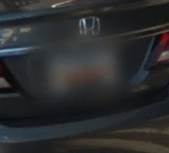
South Carolina has the bottom section of their plate as orange.
South Carolina also have a plate with a blue outer and white mid-section.
South Dakota has license plates featuring an outline of Mount Rushmore.

South Dakota plates have an outline of Mount Rushmore.
Tennessee plates can appear white but they are actually olive coloured.

Tennessee plates have some form of olive colour. The olive colour can often be hard to see therefore they regularly appear white.
Utah has either orange as a horizontal 1/3rd strip across the top of the plate or a large orange pyramid shape.
Many Utah cars have the outline of a large orange pyramid on the right of their plates.

The second type of Utah plates have an orange top section.
Vermont has green plates.
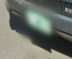
Vermont has green on their plates. This can be remembered as Vermont (verd mont) means “green mountain” in French.
Washington State contains many plates with a wispy shaded, light blue colour on the bottom of the plate.

Washington State contains this blue smudge on many of its plates.
West Virginia has a number of plates. The most common has a blue, solid, upper 1/4 and blue glow elsewhere.

West Virginia has a range of plates. The most common has a blue upper section and blue glow around the bottom 3/4.
Wyoming normally has an almost all blue plate with yellow across the base and left of the plate.

Wyoming plates are mostly blue with yellow appearing on the base and left side of the plate.
An image of a USA license plate for every state can be found here.

USA license plates are useful for determining what state you are in.
Canadian Plates
Canadian provinces have their own unique colouring and design of license plates and these can be found here. Sometimes certain province’s license plates can be recognised despite the blurring. Cars in New Brunswick and Alberta tend to have license plates with red lettering. The lettering on the license plates of Newfoundland and Labrador are also commonly red but this province can be distinguished from New Brunswick due to the lack of front plate for Newfoundland and Labrador. Cars in Saskatchewan normally have green lettering. Nova Scotia typically has plates with blue on them. Manitoba has a distinctive green section on the left and right sides of their plate much like someone who eats healthy food. Plates in Quebec are either white or mainly white with a slightly blue hue in the upper left and upper right sections.

The above plate is from New Brunswick and has red lettering that can just be distinguished. Alberta and Newfoundland and Labrador also have similar red lettering on their plates.
Saskatchewan plates have green lettering that can normally just be seen.

Nova Scotian plates typically contain blue.

Manitoba has a green section on the left and right parts of their license plate.