
 Home
Home  Membership
  TwinklCares
  Updated Help for 2022
  Catch-up Resources
  Home Learning Hub
  Create
  Blog
Blog 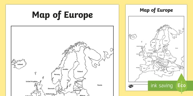
Blank Map Template of Europe
How can I use the Europe Map Outline?
Our Blank Map of Europe is the perfect way to reinforce the names of countries in the classroom. It can be used as part of a geography lesson to introduce children to the countries in this continent, or to improve a child’s knowledge of European geography.
Related Searches
 map of europe
blank map of greece
map of greece
map of europe blank labelled map template
europe map
northern europe
ancient greece map
europe
greece
western europe map
ancient greece timeline
scandinavia
world map
western europe
blank map of europe
greece map
europe map blank
france
map europe
map of europe
blank map of greece
map of greece
map of europe blank labelled map template
europe map
northern europe
ancient greece map
europe
greece
western europe map
ancient greece timeline
scandinavia
world map
western europe
blank map of europe
greece map
europe map blank
france
map europe
- Ratings & Reviews
- Curriculum Links
- Make a Request
- Resource Updates
-
thank you, very useful
-
Hello insearchofafrica,
It's always lovely to hear that people like our resources. Thank you so much for taking the time to comment. 4 years ago
✔ Thank you for your feedback
-
-
 Thank you. Useful for an individual activity and as a whole class using the IWB
-
Hi Lucia76,
I'm glad this resource is useful! Thanks for letting us know :) You might also like this lovely resource: https://www.twinkl.co.uk/resource/t-t-18428-differentiated-countries-of-the-united-kingdom-labelling-activity-sheets
 5 years ago
✔ Thank you for your feedback
-
-
I will use the maps to show the children where France and the united Kingdom are.
-
Hi andylyn1,
What a lovely way of using this! Thanks for sharing :) 5 years ago
✔ Thank you for your feedback
-
-
Hi, could I have a landscape copy of this resource too please?
-
Hi there Lucie2222,
Our lovely resource creation team have completed this and emailed the new resource to you. It will be available on our website soon! I hope you like it! 6 years ago
✔ Thank you for your feedback
-
-
Used for a German lesson about the countries of Europe. It would be nice to see this in German too. It might also be nice to add a small legend to highlight some of the smaller countries in Europe such as Liechtenstein, Malta, Andorra, Gibraltar etc with a number or star.
-
Hello KariMagee,
Thanks for your suggestion - I'll ask our design team to take a look and see if we can make this change for you :) 3 years ago
✔ Thank you for your feedback
-
-
I was using an older version which I was coming here to make some suggestions, however found this version which is much better - and have now replaced. - Thanks
-
Hello GeographyTim,
Thanks for letting us know. I'm glad we could help! 4 years ago
✔ Thank you for your feedback
-
-
This is also missing Cyprus! Definitely part of Europe!
-
Hi furthered2,
Thanks for spotting this! We'll let our design team know right away! 6 years ago
✔ Thank you for your feedback -
Hi there furthered2,
Thank you for spotting this mistake! Our lovely teacher and design teams have solved the issue and the new version is now available to download. I hope you like it! 6 years ago
✔ Thank you for your feedback
-
-
This is missing Malta. Any chance it could be added?
-
Hi greatauntmimi,
Thanks for spotting this! We'll let our design team know right away! 6 years ago
✔ Thank you for your feedback -
Hi there greatauntmimi,
Our lovely resource creation team have completed this and emailed the new resource to you, I hope you find it useful! It will also be available for download within 48 hours, and you can find it either as a new resource, or under 'Alternative versions' above. 6 years ago
✔ Thank you for your feedback
-
-
Hi, Sicily is part of Italy, not a separate country! Please adjust this for the future.
-
Hi chryssi_g,
Thank you so much for letting us know about this one. I'll get this updated right away! 7 years ago
✔ Thank you for your feedback
-
-
Hi, aren't Morocco and Algeria in Africa?
-
Hi LisaMJohnson,
I am really sorry to hear about this mistake, and I apologise if it has caused you any trouble. It will be changed shortly! 7 years ago
✔ Thank you for your feedback -
Hi there LisaMJohnson,
Thank you so much for letting us know about this issue! Our lovely resource creation team have amended the resource and emailed you the corrected version. It will also be updated on the website very soon. 7 years ago
✔ Thank you for your feedback
-
-
Nice resource but you should probably add a label for Denmark.
-
HI elainebracken, thank you for your review. I have passed this on to our design team to see what they can do. :)
 9 years ago
✔ Thank you for your feedback -
HI elainebracken,
Thank you for your comment, I'm a resource designer at twinkl and have now added Denmark to this map.
The amended version should be up on the website soon but in the meantime I have emailed it over to you :-) 9 years ago
✔ Thank you for your feedback
-
-
Please can this map be created in landscape format?
-
Hi vanessajones,
Thanks for your lovely request - I'll ask our design team to take a look and see if we can make this change for you :) 6 years ago
✔ Thank you for your feedback -
Hi there vanessajones,
Our lovely resource creation team have created this and emailed the new resource to you! I hope you find it useful! 6 years ago
✔ Thank you for your feedback
-
-
The comments below suggest that this resource was updated to include Cyprus and the thumbnail image shows this. but when it downloads it is a version without Cyprus regardless of which version I download.
-
Hi genome42,
I apologise if this mistake has caused any problems. I'll let our design team know about it right away and they will get it fixed as soon as they can! 6 years ago
✔ Thank you for your feedback -
Hi there genome42,
Thank you so much for letting us know about this issue! Our lovely resource creation team have amended the resource and the new version is now available to download. 6 years ago
✔ Thank you for your feedback
-
-
Any chance that Iceland could be added to this map? Thank you
-
Good evening andrewandjenniferneale,
Thanks for your lovely request - I'll ask our design team to take a look and see if we can make this change for you :) 7 years ago
✔ Thank you for your feedback -
Hi there andrewandjenniferneale,
Our lovely resource creation team have completed this and emailed the new resource to you, I hope you find it useful! It will also be available for download within 48 hours, and you can find it either as a new resource, or under 'Alternative versions' above. 7 years ago
✔ Thank you for your feedback
-
 Thank you. Useful for an individual activity and as a whole class using the IWB
- Twinkl added looped precursive 2 years ago
- Twinkl updated the Main Version 4 years ago
- Twinkl added Grey Backgrounds 4 years ago
- Twinkl added Editable Version 4 years ago
- Twinkl added Landscape Version 6 years ago
- Twinkl added Landscape Version 6 years ago
- Twinkl added with names and spaces 6 years ago
- Twinkl added UK Borders Version 8 years ago
- Twinkl added 4xA3 Version 9 years ago
How can I use the Europe Map Outline?
Our Blank Map of Europe is the perfect way to reinforce the names of countries in the classroom. It can be used as part of a geography lesson to introduce children to the countries in this continent, or to improve a child’s knowledge of European geography.
The Europe map outline can create a great memory testing game for your class, which will put their listening and memory skills to the best in an enjoyable and stress-free way. The template can be displayed in the classroom or at home as a helpful reminder of European geography.
Children can colour in the blank and white Europe map outline to help them remember certain places, it is a brilliant cool-down task to help children sit back and relax while also learning. Easily downloadable and can be printed, ready to go.
This blank map template also comes in an editable version, so you can customise the map to include questions for your class.
If you're teaching about Europe, why not watch this Comparing Places CPD Video.
If your class enjoyed the Europe map outline, why not test their knowledge of cities with our Map of Europe with Cities Activity Worksheet? A perfect addition to the map outline that can be displayed on the wall.
How can parents use the outline?
Our Europe Map Outline is a perfect activity to use at home. By printing off the outline, you can laminate your child's masterpiece and display it around the house.
It is great for improving your child's memory on European countries, as you can create a key with different colours that separate the seven regions in the continent. You, or your child, can decide on the colour key and do the activity together.
What are the seven regions in Europe?
- Scandinavia (Iceland, Norway, Sweden, Finland, and Denmark)
- British Isles (the United Kingdom and Ireland)
- West Europe (France, Belgium, the Netherlands, Luxembourg, and Monaco);
- South Europe (Portugal, Spain, Andorra, Italy, Malta, San Marino, and Vatican City);
- Central Europe (Germany, Switzerland, Liechtenstein, Austria, Poland, the Czech Republic, Slovakia, and Hungary);
- South East Europe (Slovenia, Croatia, Bosnia and Herzegovina, Serbia, Montenegro, Albania, Macedonia, Romania, Bulgaria, Greece, and the European part of Turkey);
- East Europe (Estonia, Latvia, Lithuania, Belarus, Ukraine, Moldova)
You could also try out our Continents and Countries Memory Game or European Landmarks Card Game for more fun geography for kids ideas.
How many countries are there in Europe?
There are over 50 countries in Europe, which include individual states.
The country with the largest population is Russia with a population of 146 million, while the country with the smallest population is Holy See with just 801 residents.
Using this map is a great way to extend your class's knowledge on the continent they live in! The great thing about our resources is that they're made by teachers for teachers. So you have the confidence that all of these maps are accurate and a great way for your class to learn about the world they live in.
Or celebrate Europe Day in the classroom with this fun and interactive blank map of Europe.
Download our blank map template to access the names of every country in Europe!