Enjoy fast, free delivery, exclusive deals, and award-winning movies & TV shows with Prime
Try Prime
and start saving today with fast, free delivery
Loading your book clubs
There was a problem loading your book clubs. Please try again.
Not in a club? Learn more

Join or create book clubs

Choose books together

Track your books
Bring your club to Amazon Book Clubs, start a new book club and invite your friends to join, or find a club that’s right for you for free.
Download the free Kindle app and start reading Kindle books instantly on your smartphone, tablet, or computer - no Kindle device required.
Read instantly on your browser with Kindle for Web.
Using your mobile phone camera - scan the code below and download the Kindle app.


Book recommendations, author interviews, editors' picks, and more. Read it now
Frequently bought together
$14.95
Get it as soon as Saturday, Mar 9
In Stock


Total price:
To see our price, add these items to your cart.
Choose items to buy together.
More items to explore
Page 1 of 1 Start overPage 1 of 1


From the Publisher


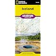
National Geographic’s Adventure Maps — Essential travel tools for destinations across the globe
With over 100 available titles, these detailed travel maps are the perfect companion for the trip of a lifetime. Sometimes an accurate, tough, waterproof map is the best travel tool you can carry. In areas without cell coverage, or when the data plan is running low, a National Geographic Adventure Map will quickly become an essential travel tool. Featuring detailed road networks, key points of interest, UNESCO World Heritage sites, a place name index, and beautifully rendered shaded relief these travel maps are perfect for pre-trip planning and on the ground navigation.
Perfect for Domestic or International Travel
- Waterproof
- Tear-Resistant
- Nearly Indestructible
- Clean Cartographic Design for Easy Navigation

|

|

|

|

|
|
|---|---|---|---|---|---|
| Iceland | New Zealand | Thailand | Costa Rica | Peru | |
| Number of International Visitors | 1.3 million | 3.0 million | 32.6 million | 2.6 million | 3.4 million |
| Official Language | Icelandic | English and Māori | Thai | Spanish | Spanish |
| Unit of Currency | Icelandic Króna | New Zealand Dollar | Thai Baht | Costa Rican Colón | Sol |


Your Purchase Has Purpose
Every purchase helps support the National Geographic Society, an impact driven, nonprofit organization with global reach that uses the power of science, exploration, education, and storytelling to illuminate and protect the wonder of our world.
Reviews with images


The must have Iceland map!
The best map I could have gotten for my 10 day road trip around Iceland. I went back and bought more at book store for Spain, France and Ireland. This map holds up well to the strain of constant folding an unfolding, is waterproof, and packed well. It wasn't detailed with all of the local roads in some places but all in all it was a great choice. The elevation feature is a must when navigating areas with few road signs and even less people. It really helped us where to go.Bonus fact: its very easy to read. I went on this trip with a friend who had never used maps before and she learned how to read this one of a foreign country a few days into our trip.
Top reviews from the United States
There was a problem filtering reviews right now. Please try again later.

Reviewed in the United States on July 11, 2021
Reviewed in the United States on September 9, 2023
Reviewed in the United States on February 29, 2024
Reviewed in the United States on December 27, 2023
Reviewed in the United States on February 24, 2024

Top reviews from other countries


Brad
Tough, durable, and accurate map
Reviewed in Canada on February 3, 2016Brad
Reviewed in Canada on February 3, 2016
Images in this review


Lenka T.
the roads are well signed and the map was very easy to read and very helpful on our ways
Reviewed in the United Kingdom on July 15, 2016