
Sometimes I’m asked whether it’s important to have a dedicated GPS navigation device for hiking and backpacking, or if a smartphone is good enough.
The general answer is, of course, “it depends.” But let’s get specific. I’ve used both over the years and I definitely have opinions about which is best under different circumstances. It’s entirely possible that my take will give me away as a Millennial, but here we go.
If you’re hiking on a maintained trail, in most cases I think you can navigate with a smartphone with important caveats I’ll get into below. This even goes for backpackers, as long as you can manage battery supply.
I know some experienced hikers swear by GPS devices and may disapprove of my take on this, but I think it’s realistic for modern-day hikers. I’d rather teach people to safely use their smartphones for hiking navigation than tell them they need an expensive GPS device they aren’t realistically going to buy.
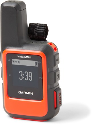
For a minority of hikers and backpackers who venture to very remote areas, travel off-trail, or expect consistently stormy weather, a GPS navigation device (like my favorite, the Garmin eTrex) is appropriate. It never hurts to have one along, and in these cases it may save your life.
I almost always use a smartphone app (with offline maps — very important!) to navigate my hikes. I bring my GPS device as a backup when backpacking in more remote areas or when a hike requires off-trail travel, or as a backup when I’m solo.


When you buy through affiliate links in this post, I may earn a small commission. Thanks for your support! I always offer unbiased opinions based on real experience from the road and trail. Learn more.
Smartphone Navigation Apps
The vast majority of hikers these days are navigating with smartphone apps. This is convenient and safe if you do it right. We’re all carrying smartphones anyway for photos, communication, and more.
I always have my smartphone with me when I’m hiking, and it’s usually my primary navigation device. Even if I’m also using a GPS nav device I still have my smartphone loaded with offline maps as a backup.
Offline Maps Always!
If you remember one thing from this article, make it this: you need to download a map or route to your smartphone so you can still navigate without mobile signal.
Folks living in populated areas might not realize there are still large swathes of the U.S. with zero cell service. I live in a major metropolitan area, yet I can still be on hiking trails without cell service in a 30 minute drive. In remote backpacking destinations like California’s eastern Sierra, you’ll be out of range for days.
All worthwhile navigation apps have an option to download maps for use in airplane mode or when your phone doesn’t have signal. Some of them require a subscription of a few dollars per month (totally worth it).
Even if you expect to have service, keeping your phone in airplane mode saves battery. I often put my phone in airplane mode even for day hikes.
I’ve run into hikers who are lost because their map has stopped loading as they’ve hiked out of service range. They’re often surprised when I ask if they have offline maps downloaded, even on ambitious routes with questionable trail maintenance. Don’t be those people! It can truly be dangerous.

Why Navigate With a Smartphone?
For many casual hikers and backpackers, and even some not-so-casual ones, smartphones have powerful advantages. Smartphone navigation is great because:
- It’s cheap / free assuming you already have one. The best navigation device is the one that’s already in your pocket or pack, not the one you didn’t buy because it cost too much.
- The interface is familiar and easy to use. Smartphones probably have the most optimized user interfaces of any device on earth, and we’re all very familiar with how to use them.
- One less thing to carry. Especially when backpacking, we like to keep our packs light and not clutter up our packing system with unnecessary things.
Smartphone navigation does have some drawbacks to be aware of, and these will be more important in some scenarios than others. Downsides of smartphone navigation:
- Limited battery life. Smartphones chew through battery faster than a dedicated nav device. You can carry a power bank or even a solar charger in some cases, but for long, remote, navigationally intensive routes a phone isn’t the best choice.
- Not as rugged and waterproof. Phone designs are improving, but I’ve personally killed two phones over the years due to rain and outdoor accidents (and I’m pretty careful). There’s always a risk of damaging your precious phone and, even worse, ending up lost because of it.
- Not as reliable. Smartphones and their apps are designed to be engaging and easy, but not failsafe. I’ve had apps crash or fail to load maps I thought were downloaded. When navigation is mission-critical in a very remote area, relying on smartphone navigation is risky.
- Not as “big picture.” Some popular smartphone nav apps work by downloading a specific route and a bit of the base map nearby. They don’t include side trails and other details, which can leave you in a lurch if you need to bail or change plans.
- Location and altitude not as precise. This depends on many details, but generally speaking a GPS nav device is a little better at knowing exactly where you are relative to the map. You’re unlikely to care if just following a trail, but if you’re hiking cross-country or dealing with a topographically sensitive route, every bit helps.

Best Smartphone Apps
If you’re going to navigate your hike with a phone app, which one is best? Please, for the love of all this good and safe, do NOT use Google Maps! Here’s a selection of quality navigation apps for hiking, all of which support caching for offline use:
AllTrails: An easy option with good topographic maps and large library of pre-mapped trails. Offline download is available in the Plus tier for a few dollars each month.
Gaia GPS: Similar to AllTrails, their route network is not quite as developed but maps are good and offline download is available for a few dollars per month.
Hiking Project: Great app for discovering trails, with a large trail database and a (free!) offline download feature. Offline download is done by entire state, not specific route, which is handy when you’re exploring an area and not totally sure which trails you’ll take. Topo maps not as good as AllTrails or Gaia though.
Avenza Maps: This app is somewhere between a GPS device imitation and a paper map replacement with a big picture view. You can download a wide range of high-quality maps, some free, many paid. It’s a great option if you’re looking for a specific map with specialized topographic or trail map features.
FarOut: Amazing app with detailed (paid) guides, data, and crowdsourced reports for popular trails, especially thru hikes like the PCT, Arizona Trail, Colorado Trail, etc.

GPS Navigation Devices
As great as smartphone apps can be, there are definitely cases where a dedicated GPS navigation device makes sense. Is your hike especially remote (you’re unlikely to see other people), navigationally intensive (off-trail, scrambling, etc), and/or long (battery life is an issue)? If you’re hiking solo, err on the conservative side with these assessments.

Why Use a GPS Device?
Dedicated GPS navigation devices have some powerful advantages over phone apps:
- More reliable. Manufacturers know you might be trusting your life to your device, so they try to make the software and firmware as bug-free as possible.
- Long battery life. Batteries might be rechargeable or replaceable, but either way they’re are designed to run for a long time. You also don’t have to worry about running down your phone battery, which you might need for other purposes.
- Waterproof and rugged. No more fiddling with your phone through a ziplock baggie with numb or gloved hands! GPS devices can be used out in the elements worry-free, and can probably take a hit if accidentally dropped.
- Precise location and altitude. Smartphones do a pretty good job of showing location, elevation, and even compass direction, but GPS devices are even better. If your route leaves no room for error in navigation, a GPS device gives peace of mind.
If that were all there is too it, everyone would hike with a GPS device. They do have some drawbacks, unfortunately:
- Expensive. Even an affordable model like the Garmin eTrex 22x costs two hundred dollars. Unless you’re really into hiking, that’s a substantial investment.
- Slow and clunky. If you’re used to the smoothness of smartphone interfaces, as we all are, many GPS devices will feel frustrating by comparison. Navigating with buttons instead of touchscreens is so last millennium!
- Extra weight. If you’re the kind of backpacker who enjoys long routes in very remote places, you probably also try to keep your pack weight light. A GPS device is one more thing to carry and keep track of.
- More of a pain to load maps. We all know how to download stuff to our smartphones, but GPS devices can be harder. You may need to connect it to your computer via Bluetooth or even an old-fashioned cable.
All that said, when you need a GPS navigation device out on the trail, you really need it! At that point it’s worth its weight in gold.
When I Would Use a GPS Device
I’m not saying my way is best for everyone, but I want to share how I personally decide when it makes sense to hike with a GPS navigation device versus a smartphone.
I navigate with a smartphone (with offline maps and a power bank for battery if needed) on almost all my hikes and backpacking trips. If I’m hiking with a buddy, we each use a smartphone and serve as each other’s backup. I’ve done this on everything from short day hikes to the 2 months I spent thru hiking the Arizona Trail.
I own a GPS device, the Garmin eTrex 22x, primarily for BIKEpacking (like backpacking but on a bicycle). In this case I find it much more essential than for backpacking, because it needs to be mounted on my handlebars in all kinds of weather and withstand the occasional crash.
When I do backpack with my GPS device, it’s in addition to a smartphone and usually as a backup. Often it’s because I’m solo on trails I don’t know well, where there’s a possibility of routefinding or not seeing other people for a few days. On these trips I’ll usually navigate with my phone but keep the eTrex tucked away for emergencies.
If I’m on a longer trip in a remote place, for example the John Muir Trail, I’ll carry the eTrex as an alternative nav method to save battery. If I’m hiking with a buddy we would each use our phones most of the time and share the eTrex as needed.
On a long and navigationally intensive off-trail route like the Sierra High Route (still on my bucket list) I would definitely take a GPS device and use it often as a primary. I’d keep my smartphone mostly tucked away to save battery for when I really need it.

Backup Navigation!
Whether you choose to navigate with a smartphone, GPS device, or both, always have a backup. Stuff happens out there, and if your navigation device fails at the wrong time and place you could really be up a creek, so to speak.
What counts as a backup? Depends on the route. On a popular and well-marked trail, honestly I may not carry a backup at all. The trail signs and other hikers serve as my backup.
If solo on a more remote or complex route I carry two electronic devices, usually my smartphone plus a GPS navigation device. If you don’t have a GPS nav device, an old smartphone will do (load it up with offline maps over wifi before leaving).
If hiking closely with a buddy on a straightforward route, both of us carry smartphones and serve as each other’s backup. On a more involved and remote route we also carry one backup GPS device between the two of us.
What about paper maps? They’re great for understanding the big picture and bailout routes. I do often carry one, but I don’t consider it a standalone backup unless the route is really straightforward. Paper maps aren’t very useful unless you know where you are, and it’s easy to lose track. If there’s any chance of losing the trail due to washouts, snow, cross-country travel, etc then a GPS track, either on a smartphone or dedicated navigation device, is important for safety.
If you’re a whiz with a map and compass, your situation is a little different, but you’re probably not here reading this article anyway.
Navigation Versus Communication
The term “GPS device for hiking” is actually ambiguous, because there are two ways hikers use GPS. One is navigation as we’ve been discussing: keep the dot (your location) on the line (the trail) or choose your path across the landscape using a topographic map.
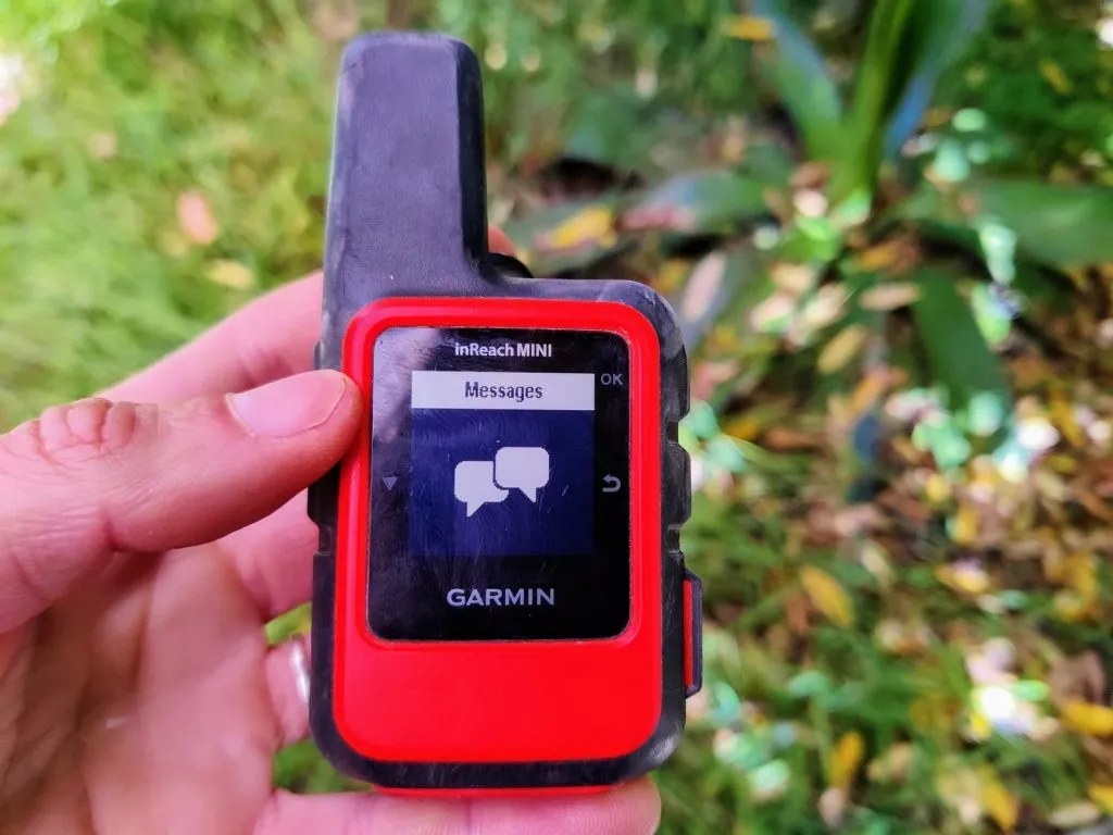
Another very important use of GPS while hiking: communicating your location. A satellite communication device or GPS tracker can transmit your GPS location and other information, sometimes including a custom message, even when you have no cell service. The two most popular devices in this category are the SPOT and Garmin InReach (I like the InReach Mini personally).
Both types of GPS devices know your location, but one is focused on helping you navigate a trail or map while the other is about transmitting your location.
I think satellite communication devices are really useful and important. Even if I’m navigating with a smartphone, I usually still have my InReach Mini in my pack. Though I hope to never use it for this purpose, it’s a backup-backup-plan in case something goes wrong out there, including getting lost due to navigation issues.
As you can hopefully see by now, not every hiker needs a GPS navigation device. Smartphone apps are cheap, easy, and work well in many cases. If / when it comes time to step up to a GPS navigation device because your hiking adventures have grown more remote and involved, you can feel confident it’s worth the money.
To my experienced readers, do you agree? How do you decide whether a GPS device is important for your hikes? Am I being too much of a Millennial by favoring my phone? Let me know in the comments below!
More Hiking Resources
If this post helped you, check these out too:
- How to Choose the Ideal Backpack Size
- Bladders, Bottles, and Beyond: Carrying Water While Backpacking
- 6 Reasons to Thru Hike the Tahoe Rim Trail
Or visit the hiking and backpacking section for lots more.

About the Author
Hi there, I’m Alissa, founder of Exploring Wild. I’ve had the pleasure of hiking the Arizona Trail, Colorado Trail, John Muir Trail, Tahoe Rim Trail, and countless shorter amazing trails throughout the US and abroad. I love solitude, big views, and a good lightweight gear setup. Learn more here.
Excited about backpacking but need help getting started? The Backpacking Trip Planner Workbook will help you start off on the right foot.

Hiking resources in your inbox?
There’s more where this came from! Sign up here for occasional emails full of inspiration and information about backpacking and hiking.


Good tips on using a Smartphone. Using one to do routefinding uses a surprising amount of battery life. Be aware.
I was a professional trip leader back in the ’70’s when all we had were paper maps. They still work fine IF you can place your position. The best way is to practice your route before leaving and remember some landmarks.
Great points, I agree. Part of me wishes I had learned to use a paper map as the only option, because it’s a good skill to have!
Agree with your recommendations.
I do use a Garmin Inreach in addition to my phone, especially when hiking solo. Features that I consider essential on the Garmin is the ability to have an SOS button to call for a rescue in any circumstance as well as the 2 way satellite messaging function (blue tooth pairing with the phone for easy writing) and allowing to send a link to my emergency contact, which updates every 30 minutes. I very rarely use the map on it. Regarding the phone, I always carry a small back-up battery with both USB and solar capability. For navigation on the phone, I prefer using Gaia, which is significantly better than AllTrails, particuarly when outside the US. The premium membership allows to load local maps as an overlay. For example the Swiss map for Switzerland or IGN maps for France. Another essential feature is that you can create a “Route” (trail) on your computer, which will automatically download on your phone. I considered AllTrails initially, but discovered that it was inadequate for Western Europe as the trails are often imcomplete or very low resolution. My experience is based on hiking the GR10 in the Pyrenées, the Via Alpina and the West Highland Way.
Finally, I also carry a good quality compass and paper maps printed from Gaia for the areas where cell phone service is not available. I use the Micro Navigation principles when using map and compass. I trained myself using the Ultimate Navigation Manual by Lyle Brotherton and practicing on permanent courses in State Parks until I could complete the advanced courses.
Happy Hiking
Michel
Hi Michael, thanks, this is great information. I need to play with Gaia more, as it does seem like a great option for less straightforward routes. Good to know about the regional differences too. Happy trails!