
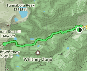
Sei auf diesem 14,2-Kilometer langen Hin- und Rückweg in der Nähe von Lone Pine, Kalifornien vorsichtig. Die Route gilt allgemein als sehr anspruchsvoll und sollte nur von erfahrenen Abenteurern begangen werden. Obwohl sich der Weg bestens zum Trekking, Klettern und Skifahren eignet und oftmals gut besucht ist, kannst du hier zur richtigen Tageszeit ein bisschen Ruhe genießen. Die beste Zeit für einen Besuch dieser Route ist von Mai bis Oktober. Hunde müssen leider Zuhause bleiben, da sie auf dieser Route nicht erlaubt sind.
| 5 | ||
|---|---|---|
| 4 | ||
| 3 | ||
| 2 | ||
| 1 |
Hiked Dec 8. Mountaineer’s route up, regular trail down. Temps not too bad wearing lots of layers but took a beating from strong winds going up the notch, especially cold cause we started from car at 9 pm. Use trail and ledges easy to navigate in dark, gpx track comes in handy when boulders take over. Snow in gully was firm, sometimes icy, a few small mixed steps. Decided on traverse as it was so dang windy but bailed off it and scrambled up instead as traverse turned extremely icy and purchase didn’t feel great even with tools. @twooutofthree
Cold and icy was the conditions on 12/1/23. Acclimated at the trailhead we camped at UBSL. With wind chill we were hitting -10 degrees. Couloir had some fresh snow at the base we postholed in. Most of this is ice. Team called just below the notch so I didn’t see the 400 or walk off. If it’s anything like the rest it’s hard ice. Great time coming back to finish in a couple of weeks.
Quite cold, water will freeze even in bottles, bladders are basically useless. Bring thermos. Iceberg lake completely frozen. No liquid water source in the upper mountain. Gather water whenever possible. Bring a gas stove in case. Good snow in the chute for kick stepping, nothing sketchy. Didn’t do the class 3/4 scramble route, too cold for hands to work
Started at 6:10, summit 12:45, at car 19:40 (taking hiker route down). Did route with uSpikes + alpine axe + helmet, although I recommend crampons, the top of couloir + traverse around the Notch are both water ice at points. Very scary French traversing in the spikes! ----------- Crampons add security to low-down iced creek crossings but not necessary. I donned spikes at 11k ft and felt good about that timing. ----------- Couloir exhibited slab layer ~60cm down which felt well-bonded when probed. Top layer wind-scoured but no convex rolls, all snow well supported with no overhead hazard. I felt safe on it w/o avi gear but if apprehensive one can switch to climbing the rib of rock to climber's right at around the half-way mark up the couloir. PERFECT step-kicking up the lower half, just enough crust to support with just enough give to sink the foot in. ----------- Unless getting a VERY early start (like 3 or 4 AM) I recommend taking the hiker trail to descend as it is much easier & safer to follow in the dark. The whole journey took me 13.5 hours at a leisurely but consistent pace in about average condition. The mountaineer's trail has lots of false offshoots that would necessitate lots of stopping to GPS/routefind which slows things to a crawl at night. Plus the traverse along the backsides of the gendarmes is incredible! All in all highly recommend, just prepare accordingly, it can get scary very rapidly out there.
Most creek crossings were icy. There were 6 major creek crossings (one not shown in the map). The gulch was covered with snow and ice. It was windy and cold at the Iceberg ice. The last section up to the Iceberg lake was covered by ice and it was hard to proceed. Other than these, the trail was good.
I have climbed many 14ers, and done the mountaineers route three times. I am 67 and would do it again. It is one of the easier mountaineering routes up a 14er. The description here is a little too alarmist. You should have some mountaineering experience to be safe, but I have guided up enthusiastic hikers in their 20s with no experience without difficulty. The use trail has become so well stomped that route finding is not difficult. The Ebansbacher Ledges are easy but with significant exposure. The other difficult section is the short cliffs that guard the final approach to Iceberg Lake. But there is a clean route if you continue west for a distance before going up. The 1400 foot climb from Iceberg Lake to 14 000 is not hard. I prefer to avoid the lower chute by staying on the rocks to the left, which merge into the chute half way up. The rocks are no big deal. At most class 3 in a spot or two. The last 400 feet of gain above 14000 is class 3 in a few places and otherwise a steep class 2-3 scramble if you stay to the left and then the middle right. There is an easier bypass that I did once. At 14,000 and at the bottom of the last 400 feet, traverse right (west) along the base of the steep wall and parallel to the summit plateau for up to a few hundred yards. The north face can be very steep, but there is a moderately sloping section on this traverse. As you move west, the height of the plateau is dropping, so the vertical climb shortens. There are easier climbs up once you go far enough west. It ends up being a kind of switchback as you reverse direction and head east back to the summit. This year, 2023, the Notch area never fully cleared of snow and ice making it very dangerous (it's a north exposure). This section kills climbers when it is in that condition, including the Air France pilot in October, 2023. The hikers in their 20s thought it was the best hike of their lives. It was their first exposure to mountaineering.
Summited with a buddy on 08OCT with a start time of 0440 at the Whitney portal and an end time of 1210. Not for the weak or faint hearted, this is a serious excursion with real danger with the recent snowstorm. We brought ice axes, microspikes, and a 20ft rope for short roping; this was inadequate. This was by and far the most fun I have ever had on a mountain. You start on the Whitney trail and go less than a mile up. Right before you cross the Lone pine Creek, there is a sign. Go right here and then follow the route (pretty well defined) till you get to the E-ledges. They aren't bad and not hard to navigate, if your ledge is less than 5ft across, you are on the wrong ledge. Then, when you get above Lower Boyscout lake, don't ascend to the south, but handrail the stream till you see the obvious left (you will turn south) turn up the hill. You then follow below the Ridgeline for a while till you get to the first icy stream coming down. This is not where you ascend to iceberg, go 100m more to the west and you will see a nice scree slope to go up. Iceberg is frozen with 3 inches of ice, we cut through it with ice axes for water. The steepest part of the couloir can be bypassed via a rock chute on the left (south) that is a really fun class 4. The top half of the couloir has a bootpack and was not hard with microspikes. The notch is problematic. The normal final 400 on the left (facing south, this would be on the east) is completely covered in water ice. The class 2 bypass is filled with snow. We took the arete on the right only to figure out that we were unable to downclimb or rap, so we had to go up. It was probably a roped 5.3 but with the conditions it felt like free soloing a 5.7. Legitimately one of the most terrifying things I have ever done and would not try to do again. The top half of the arete is 5 easy and the summit ridge you can see from the notch is the actual ridge. Bring mountaineering boots, crampons, an axe or two (shorter is better here) and a trad rack and 60m rope if you want to rappel (no rap rings). We descended via the Whitney Trail, which doesn't quite need microspikes but they are nice to have. It is way longer than 11 miles (or at least feels it) and it took us 5:30 to descend for a total trip time of 13:10. The trail descends so slowly and is mentally infuriating compared to the mountaineers route. The Mountaineers route is the most fun and exhilarating experience I have ever had on the mountains. With our lack of acclimatization (we did white mountain peak the day before) this was harder than a Rainier summit day via DC from Muir and much harder than Longs Peak via the Keyhole route. Have good rock climbing and scrambling skills, the right gear and pro, and good route finding experience for an incredibly diverse and unique route up Californias tallest peak. Here are links to the videos that I took showing the conditions: Pt.1 (Top half of coilour): https://youtu.be/QGOOAvpTrYo?si=eq9XLg1NdpcxC9-8 Pt.2 (Notch into Lower Final 400): https://youtu.be/cUdfzIHzdLY?si=Jdm-VOK3pM-eYbsj Pt. 3 (Upper Final 400): https://youtu.be/d8bTKebkx8Y?si=J2vHRLntnRnknmnn
Coming down after a full day (15hr) push via East Buttres Route and returning via Mountaineers Route was a good effort. Coming down the technical sections and crossing the multiple rivers/waterfalls was challenging. But the amazing weather and views made every effort and steps worth it!! Recommed this trip to anyone serious enough to hike/climb Mt Whitney
We were definitely lucky as we got a great weather window. The hike to Iceberg lake is long with some steep areas plus the technical sections of the ledges before lower boyscouts lake, and the last steep section after upper boyscout lake and iceberg lake. The views of Mt Whitney and the surrounding peaks is incredible! Worth every step!
So please read if you’re attempting this soon. What a sick experience!! There’s a lot of unclear, washed out etc spots especially on the first half of the trail. I got lost and had to re route more than once. Anyways m, I was the only one out of probably about 10+ others I saw turn back to avoid scrambling the last 300 feet up around after that main chute. It is very icy, the chute is totally a go but you really don’t hear much about that last 2-400ft on this app. If you’re confident and you have good gear go for it
We left midnight group of 4 for day hike. Took longer then expected to get to iceberg lake. There were some campers there taking buttress class 5 route with ropes. They said the chute was impassable and sketchy because of the snow up the chute. I didn’t attempt the chute but watched 2 in our group do it. They stayed to left on the class 4+ and climbed above the first patch of snow. The last bit of snow they used crampons and ice ax and carved steps. We didn’t see them again until the main trailhead. They said it was sketchy as f$&k but they have rock climbing skill and stoked they did it. So be mentally prepared for the final chute with snow unless you want to come back down without the summit. It was beautiful back down. Fist Whitney attempt for me so I had no complaints. Hell of a hike.
I hiked to Upper Boy Scout lake 8/25/23 and attempted to summit via the MR the next day on 8/26/23. Getting to UBSL was pretty straight forward except for the stream crossings. There are 2 crossings before Lower Boy Scout Lake that I was worried about. We crossed the first on a tree that had fallen but we became worried that the next crossing would be unpassable so we decided to cross back over and take another route. The route we took avoided any crossings by staying North (right) of the stream and hugging the cliffs. Turns out this area was super dense with plant growth so it was slow and tedious with overnight packs that caught on all the shrubs. On the way back we stuck to the trail and crossed both stream sections with no issues which was much easier. The next day when we got to Iceberg Lake some people camping there told us to avoid the whole lower part of the chute (which was filled with a snowy mess) by scrambling to the South (left) of it and then reconnecting higher up. There was a small section of the chute that had snow after we reconnected. Once we got up to the notch and saw what the final 400 looked like we decided to turn back. It was covered in snow and ice and neither me or my friend felt comfortable with the level of exposure mixed with the condition it was in. It was still a great trip though. The weather was perfect and the scenery was amazing. One thing I'll say for anyone who hasn't done the MR is that as long as we were on the route that my GPS was leading me on, there was nothing super dangerous or sketchy. Whenever we got to something that felt like high class 3 or low class 4 with lots of exposure we were always off route.
Trail was great. No switchbacks just steep rock scrambles across the mountain. I brought ice axe, crampon, mountaineering boots, but if you're bold and decent of a rock scrambler you can do it in just hiking shoes I wish I brought hiking shoes. Chute has decent snow but most can be avoided until right by the summit but depending on time the snow is soft enough you can climb it in boots. Highly recommend this trail if you like bouldering and don't mind a bit if exposure. Really stare at the trail map it's very easy to go off. Took me about 9 hours but I was moving slow -- had perfect weather. Also, all water crossing can be done without getting feet wet so no need for sandals. Did 8/18, not sure how storm is going to affect it
Summited 8/15. Poor weather the whole way but it worked out. Snow conditions were prime in the couloir (ice axe + crampons required). Ledges above were wet but would dry fast with good weather. Great route! Went down the Mt Whitney trail for a nice tour, but much longer that way.
Just did my 4th summit which humbled Me just as much as the first one. Started at 12Am on a clear day. The L-Boyscout lake crossing will get your feet wet so be prepared. (Trail fades in and out the whole time) Lower to upper lake climb kicked my a$$. Snow starts after 1st lake but I didn't geared up until I made it to Iceberg Lake( Crampons, Axe, Helmet. Goggles, etc.) The chute is mostly covered in snow which makes it easier to climb but the multiple false summits will discourage you. The final 400ft wall was straight forward but dangerous with the ice. I enjoyed the 360° views then headed down via Main Trail. I took the Glissading Route( instead of switchbacks) which was pretty steep and dangerous but really fun. Difficulty for me is as follows: Main Whitney Trail to Hut (moderate) Portal to Lower Scout Lake (Hard) Lower Lake to Upper Lake ( Extremely Hard) Upper Lake to Iceberg Lake ( Hard) Iceberg to top of Chute ( Extremely Hard) 400 ft wall climb to Hut (Moderate but Dangerous) TIPS: acclimate, rest up, start early, know your limits and take your time. Follow me IG: solocrazyadventures
Completed the ascent to Mount Whitney via Mountaineer’s Route 7/27. Snowy conditions made orienteering on the route trickier past Lower Boyscout adding a lot of extra time and mileage to our summit with bushwhacking. River crossings were fast, the one past LB had snow bridges on portions on the verge of collapse. No crossing was above mid-thigh. The last 400 to the summit is a class 3 scramble. We were forced pretty far to the right due to snowpack requiring more technical moves than is likely typical at this point in the season. I would not have minded a rope at various points of the ascent. Watching footage of this section from past seasons looks nothing like what we experienced with the current amount of snowpack—it was pretty slick with melt in much of the area. Make sure you have a reserve of energy to complete this section after the chute. I mistakenly thought the chute would be the most difficult part of the summit and was pretty exhausted by the start of this section which made it take much longer than anticipated. Getting to the top was surreal and truly incredible, but the conditions are not ideal. I would strongly recommend camping at Upper Boyscout instead of trying this route in one day with the current conditions, unless you are experienced.
summited on 7/12 like others have said water crossings are much higher than usual, bring some extra shoes for that if you dont want wet boots. I camped at upper boy scout, left at 4am summited at 8am, the sun cups are pretty gnarly and it was super slushy on way down, i'd reccomend to leave even more early than that.
The trail below lower boy-scout is partially covered by avalanche debris and difficult to follow, especially during night. The first river crossing requires walking on fallen trees above rapids. Above lower boy-scout lake is all snow, firm until mid morning and then start softening. Good step to walk. Great route, much harder than the regular trail. Upper part need crampons and ice axe. Start early to avoid snow melting in late morning at the chute.
Summited on 7/8, only one out of 6 in my guiding group to summit, the conditions are unusual at this time, plenty of snow above upper Boy Scout lake, lot of postholing, the streams are flowing heavily especially later throughout the day, lot of bushwhacking, your feet will get wet with the crossings, I brought keen water shoes to avoid getting my M boots and socks wet, u will need crampons with M boots and gaiters past upper Boy Scout, the last 400 is the most technical right now, icy, and safest approach was to rock climb to summit on the left, this is at least class 4 to 5 rock climbing, I would have not summited without my guide from IAG- Connor Chilcott- he was superb and I would recommend that u go with a guiding agency in order to make a safe climb to the summit at this time until conditions improve, this trail route requires advanced mountaineering skills and experience, high endurance and strength, and much high altitude conditioning before attempting this safely, these are my honest thoughts as safety is the most important here without adequate experience and training