


This is a carousel. Use Next and Previous buttons to navigate

For miles in every direction, you are surrounded by glacier-sculpted granite, azure lakes and snowfields stretching to the Crystal Range to the west and Mount Tallac to the east.
The air tastes light and clean, and that's because in the Desolation Wilderness up at Tahoe, it is.
While San Francisco is buried in fog and the Sacramento Valley hits 100 degrees this week, the first days of spring are arriving to Desolation Wilderness and the high Sierra Nevada. It's been eight months since hikers have set foot here. As the snow finally melts off and Desolation is unveiled, hikers can once again discover a quiet, pristine and stunning wilderness that provides the best, easy-to-reach wild places in California.
From the marina at Lower Echo Lake, you can take a hikers' boat taxi for 2.5 miles to a trailhead for the Pacific Crest Trail, and then, within a hiking range of 3.5 miles, have your choice of five lakes in Desolation Wilderness with water-view campsites. Or you can turn the trip into one of the best day hikes in the state and stay overnight at Echo Chalet or at South Lake Tahoe. The trailhead at Upper Echo Lake is one of the best five trailheads in California that provides easy access to wilderness lakes (see sidebar).
This trip, along with other easy backpacking destinations, provides a place for youngsters to make their first trip, or for those who wonder if they are up to the physical challenge of carrying their own gear in wilderness.
It's been a long time coming this year after a mammoth winter that turned the high Sierra into a deep freeze. On Memorial Day Weekend, there was still 14 feet of snow above Leavitt Lake near Sonora Pass, for instance. This week, the Sierra crest from Mount Whitney north to Tahoe is still loaded in shaded pockets and high passes, with deep snow packs at the approaches to Whitney (14, 497 feet), Forester Pass (13,180) and Muir Pass (11,955).
But in the past month, hot weather is melting off about three inches of snow per day. Most of the Pacific Crest Trail is now accessible from north Tahoe to Oregon, a distance of 565 trail miles, and quickly opening in the Sierra Nevada.
Desolation Wilderness, one of the prettiest of all high-country wildlands, is the first world-class wilderness in California to provide significant access. In the past two weeks, the routes to Lake Aloha and several other alpine lakes have largely cleared of snow, the ice on the lakes is gone, and finally -- in mid-July -- spring is here.
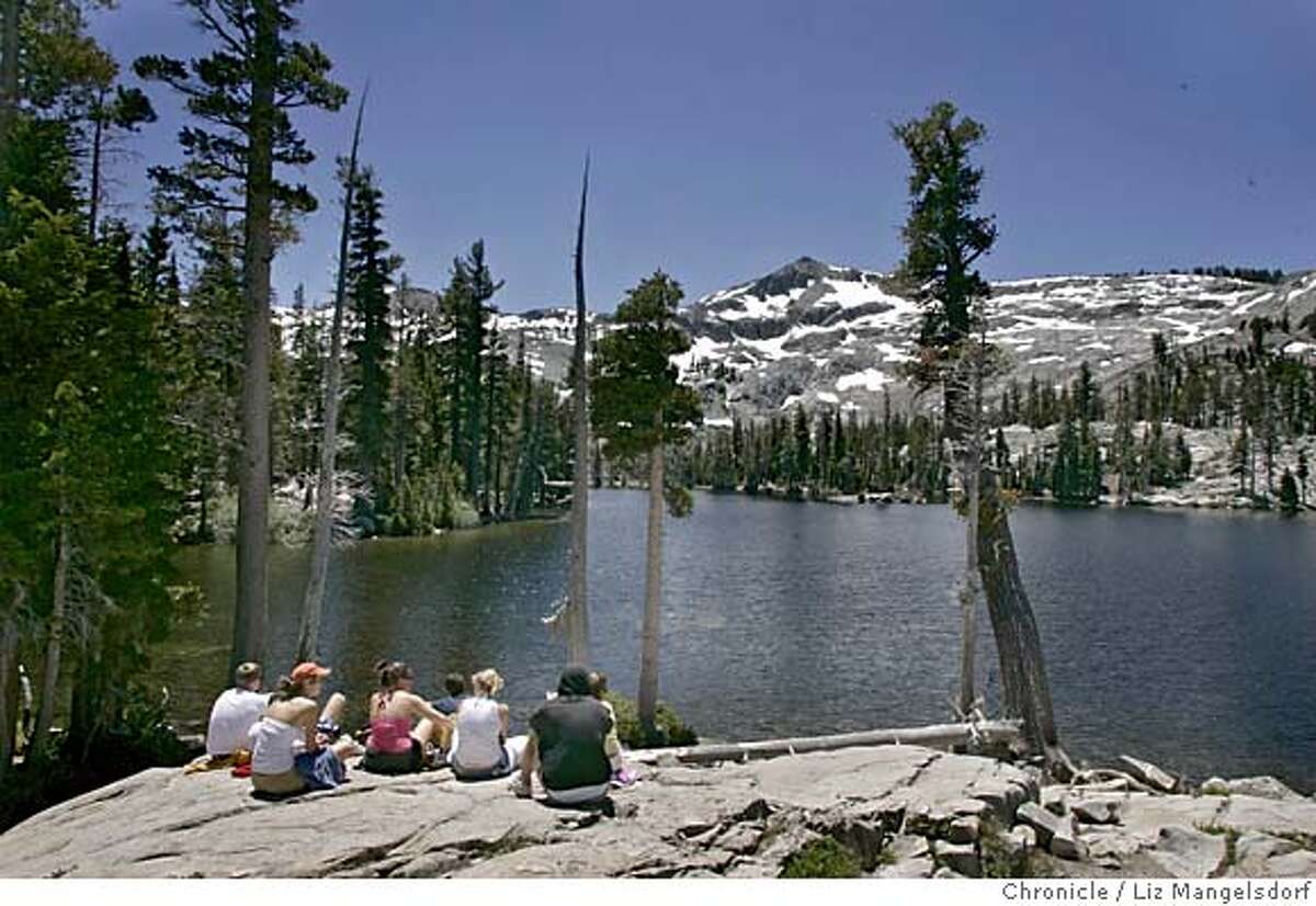
Desolation is located roughly west of South Lake Tahoe. It's a vast wildland, mostly above tree-line and sprinkled with dozens of gem-like alpine lakes, where the cobalt-blue water contrasts with the slab granite and remaining snow fields.
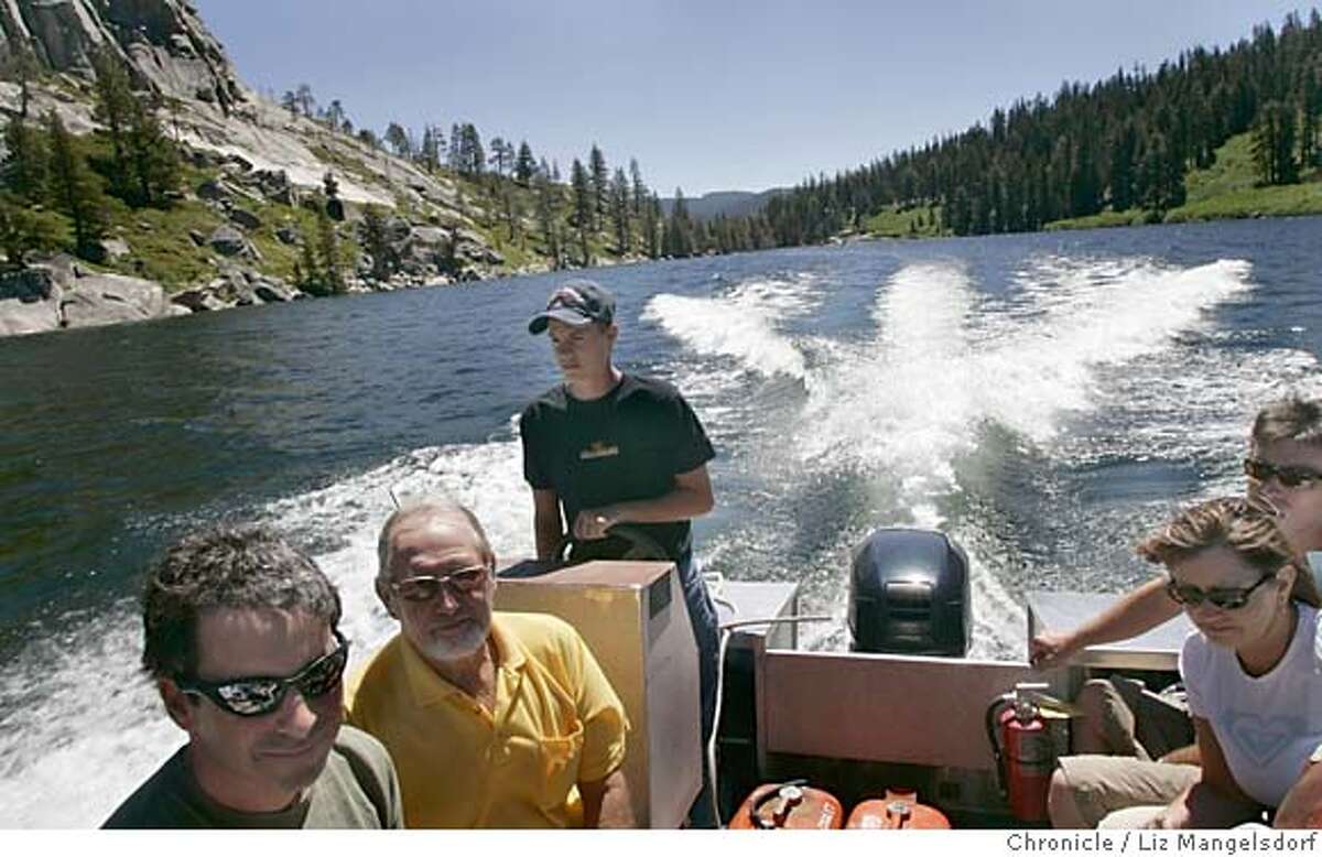
The best starting point for hiking and backpacking access is at the small marina for Echo Chalet. From here you can hike 2.5 miles along the east shore to the boundary of Desolation Wilderness, or for $8.50 per person and $3 for dogs, short-cut the trip by taking the boat taxi.
This is a boat ride in paradise, a low-speed cruise across the deep waters of Lower Echo Lake, through a short, winding strait that connects the lakes, and then across pristine Upper Echo Lake to a forested shore. Some of the prettiest mountain cabins in the Sierra overlook these lakes, with access only by boat. The boat taxi will drop you at the head of Upper Echo Lake (elevation 7,400 feet), and from here, a short cut-off trail hooks up in minutes with the Pacific Crest Trail.
You turn left on the PCT and then climb 1,000 feet over the course of 1.6 miles to a sub-ridge. This is a steady, rhythmic climb, not a butt-kicker. As you rise, you can turn and take in the first of many spectacular views. To the east, you can see across Echo Lakes, over a ridge, for a distant glimpse of Lake Tahoe.
After topping the ridge, you pass through a few pockets of stunted pines, and then make a gradual descent to the edge of a vast, granite landscape crowned by 9,735-foot Mount Tallac on your right and 9,586-foot Jacks Peak to the far north. By now, the walk is easy, near flat, and 2.5 miles in, you will reach the turnoff (well-signed) for Lake Aloha. Turn left, and in a few minutes, the lake will come into view. In 10 minutes, you will arrive at the shore of the lake (8,116 feet).
There may be no more pristine wilderness setting anywhere that you can reach with only a 2.7-mile hike. The ice cleared from the lake last week so Aloha looks like a water sapphire set amid ice diamonds. Looming to the west is the rim of the Crystal Range, topped by ice-covered Mount Price (9,975 feet) and Pyramid Peak (9,983 feet), with alpine granite and snowfields extending for miles.
But there's more to see -- on this hike, the hits just keep on coming. That is because a series of cut-off trails from the PCT provides access to several other lakes.
From Lake Aloha, you can hike the trail to nearby Lake of the Woods, and then link back to the PCT. This is the most popular loop in the area. It makes for a sensational day hike, or for those with overnight Wilderness Permits, there's a choice of many campsites with flat tent spaces with lake views.
Another can't-miss trip is the hike to Tamarack Lake, the easiest trek in Desolation Wilderness. To reach it, you head up the PCT as if heading to Lake Aloha, but instead take the first left cut-off trail (signed). This route drops down into a canyon where Tamarack is nestled amid rock and a spare pine forest. This is one of the prettiest destinations in the area. The lake is the tinted like tourmaline, that is, a deep blue-green, and is crystal clear.
Other nearby lakes along the PCT here that can add to your hike include Lake Lucille and Lake Margaret. As summer arrives and the snow melts off, week- long backpack treks here can feature climbing the back side of Mount Tallac for its top-of-the-world lookout of Lake Tahoe, or heading north on the PCT some 60 miles to Donner Pass, with pretty lakeside campsites every night for a week.
With the snow finally clearing in the high country, you can again be surrounded by an untouched natural paradise.
"The Great Outdoors With Tom Stienstra" airs Sundays at 6:30 p.m. on KBHK- TV (Channel 44) and Bay Area Cable 12, and 3 p.m. on KPIX/ CBS-5.
Tom Stienstra's Outdoors Report can be heard Saturdays on KCBS (740 AM) at 7:35 a.m., 9:35 a.m. and 12:35 p.m.
If you want to go
Day-use permit: Day-hikers must fill out a day-use permit at the wilderness trailhead.
Camping permits: Desolation Wilderness Permit required for each group, with trailhead quota in effect; 50 percent available by reservation, 50 percent first-come, first-served. Reservations at (530) 647-5415, $5 per party per permit (have only one person in your group make contact); plus $5 per person for first night or $10 per person for two or more nights for up to 14 nights. Children 12 and under are free. Keep group size small.
Echo Lakes taxi: Boat taxi available at $8.50 per person, $3 for dogs.
Trail use: Hikers, horses and dogs (not advised because sharp rocks can bruise foot pads). No mountain bikes.
Maps: Desolation Wilderness (by Forest Service), $7, U.S. Forest Service,
Attn: Map Sales, P.O. Box 9035, Prescott, AZ 86313, (928) 443-8285, or Web site: www.fs.fed.us -- click on "Maps & Brochures"; Desolation (by Tom Harrison), $8.95 from Tom Harrison Cartography, (800) 265-9090 or www.tomharrisonmaps.com.
Weather: Dress for cool mornings, warm afternoons.
Fishing: Trolling good, early morning at Lower Echo Lake; 8-pound brook trout caught this month.
Lodging: Echo Chalet, 20 percent availability, (530) 659-7207 or www.echochalet.com; 1-800-AT-TAHOE or www.mytahoevacation.com.
How to get there: From San Francisco, take I-80 east to Sacramento and U. S. 50/South Lake Tahoe. Bear east on U.S. 50 and drive to the signed turnoff for Echo Lakes/Johnson Pass Road (one mile west of Echo Summit). Turn north (left) and drive half mile to Echo Lakes Road. Turn left and drive one mile to parking (quarter-mile before road ends at resort). Hikers not staying at resort must park in upper lot.
Contact: Forest Service Visitor Center, (530) 543-2674; Lake Tahoe Basin Management Unit, 35 College Drive, South Lake Tahoe, CA 96150; (530) 543-2600, ext. 1; www.fs.fed.us/r5 -- click on "Lake Tahoe Basin."