Tropical Storm Nicholas Tracking To Rain Ravaged Region.

BY: WEATHER TEAM | BocaNewsNow.com
BOCA RATON, FL (BocaNewsNow.com) (Copyright © 2021 MetroDesk Media, LLC) — There are two systems of note that are likely to form east of Florida over the next several days.
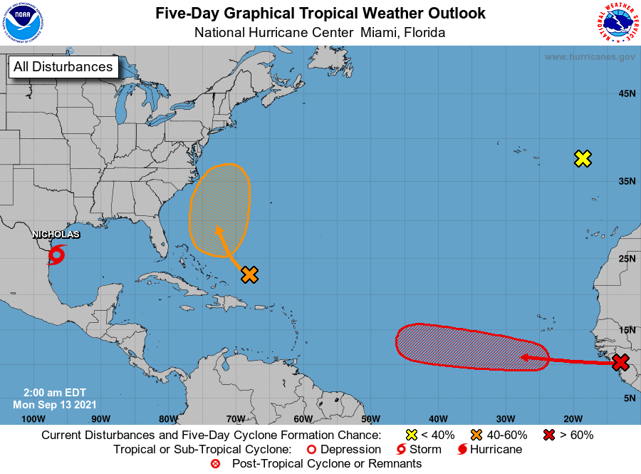
The wave that you see above in red has a 70 percent chance of developing into a tropical cyclone within the next five days.
The wave marked by the orange oval has a 50 percent chance of development over the next five days.
Ovals indicate where a storm may form, not necessarily a direction of travel.
Meantime, Tropical Storm Nicholas continues on a path to the rain ravaged region still cleaning up from Hurricane Ida.

The next storm names: Odette and Peter.
This is the early morning update from the National Hurricane Center:
Tropical Weather Outlook
NWS National Hurricane Center Miami FL
200 AM EDT Mon Sep 13 2021

For the North Atlantic...Caribbean Sea and the Gulf of Mexico:

The National Hurricane Center is issuing advisories on Tropical
Storm Nicholas, located over the western Gulf of Mexico.

1. A tropical wave is expected to emerge off the west coast of Africa
later today.  Environmental conditions are forecast to be conducive
for gradual development of this system thereafter, and a tropical
depression is likely to form by late this week while it moves
westward at 10 to 15 mph across the eastern tropical Atlantic Ocean.
* Formation chance through 48 hours...low...20 percent.
* Formation chance through 5 days...high...70 percent.

2. An area of low pressure is forecast to form by midweek a couple of
hundred miles north of the southeastern or central Bahamas as a
tropical wave interacts with an upper-level trough.  Some gradual
development of this system is possible thereafter, and a tropical
depression could form later this week while the system moves
north-northwestward or northward across the western Atlantic.
* Formation chance through 48 hours...low...near 0 percent.
* Formation chance through 5 days...medium...50 percent.

3. Showers and thunderstorms remain very limited in association with a
non-tropical area of low pressure over the far northeastern
Atlantic, about midway between the Azores and Portugal.  Tropical or
subtropical development of this system is no longer expected while
it moves eastward and then inland over Portugal by late Tuesday.
* Formation chance through 48 hours...low...near 0 percent.
* Formation chance through 5 days...low...near 0 percent.

Public Advisories on Tropical Storm Nicholas are issued under
WMO header WTNT34 KNHC and under AWIPS header MIATCPAT4.
Forecast/Advisories on Tropical Storm Nicholas are issued under
WMO header WTNT24 KNHC and under AWIPS header MIATCMAT4.
This is the Nicholas update:
Tropical Storm Nicholas Discussion Number   5
NWS National Hurricane Center Miami FL       AL142021
400 AM CDT Mon Sep 13 2021

Radar data from Brownsville shows that the center of Nicholas is on
the southwestern side of a large area of deep convection over the
western Gulf of Mexico.  While southwesterly shear continues to
affect the storm, the radar presentation has recently improved,
with what could be the start of a partial eyewall forming in the
northern quadrant.  The initial wind speed remains 50 kt based on
earlier aircraft flight-level winds of 59 kt, believable SFMR
values up to 50 kt, along with radar winds at 5000 ft near 60 kt.

The storm is moving north-northwestward at about 12 kt.  Nicholas is
forecast to turn northward soon into a weakness in the subtropical
ridge.  The track prediction is only nudged slightly westward from
the previous one through landfall, consistent with recent model
guidance.  Thereafter, there isn't good agreement among the models
on how quickly the tropical cyclone will move northeastward out of
Texas.  Generally the models are faster this cycle, which seems
believable given the large northward re-formation earlier likely
exposing Nicholas to stronger mid-latitude flow.  Thus the new NHC
forecast is trended faster as well, but remains behind the model
consensus.  Obviously the forward speed is important to the heavy
rainfall forecast, and this trend will be one to watch.

Nicholas should continue to strengthen up until landfall due
primarily to the very warm Gulf waters and the recent inner-core
improvements.  Moderate southwesterly shear and some dry air are the
main inhibiting factors and will hopefully keep the strengthening in
check.  However, it is possible that Nicholas could become a
hurricane before landfall, and that's the reason for the hurricane
watch area.  Nicholas should weaken after landfall, diminish into a
tropical depression within a couple of days, and degenerate into a
remnant low in about 3 days.  No significant changes were made to
the previous NHC wind speed prediction.


Key Messages:

1.  Heavy rainfall will impact portions of the Texas and Louisiana
coasts through the middle of the week. Significant rainfall amounts
are possible, potentially resulting in areas of considerable flash
and urban flooding, especially in highly urbanized metropolitan
areas. Isolated minor to moderate river flooding is also expected.

2. There is the danger of life-threatening storm surge inundation
along the coast of Texas from Port Aransas to San Luis Pass.
Residents in these areas should follow any advice given by
local officials.

3. Nicholas is forecast to approach the middle Texas coast as a
strong tropical storm today, and could be near hurricane
intensity at landfall.  Tropical storm conditions are expected
along portions of the middle Texas coast beginning by this
afternoon, with hurricane conditions possible from Port Aransas to
Freeport this afternoon and tonight.

4. Tropical storm conditions are expected along portions of the
northeastern coast of Mexico and the coast of south Texas beginning
during the next few hours.


FORECAST POSITIONS AND MAX WINDS

INIT  13/0900Z 25.5N  96.6W   50 KT  60 MPH
 12H  13/1800Z 27.3N  96.8W   60 KT  70 MPH
 24H  14/0600Z 29.2N  96.5W   45 KT  50 MPH...INLAND
 36H  14/1800Z 30.6N  95.8W   35 KT  40 MPH...INLAND
 48H  15/0600Z 31.5N  94.5W   30 KT  35 MPH...INLAND
 60H  15/1800Z 32.1N  93.0W   25 KT  30 MPH...INLAND
 72H  16/0600Z 32.5N  91.5W   20 KT  25 MPH...POST-TROP/REMNT LOW
 96H  17/0600Z...DISSIPATED
