Signup for weekly updates on new printable items!
100% Privacy Guaranteed! ![]()
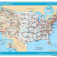
US Map- States

This outline map is a free printable United States map that features the different states and its boundaries. Each state is labeled with the name and the rest is blank. This free printable map is excellent to use as a coloring assignment for a younger student. Print the map without the state names printed for a worksheet or test to learn the shape and location of each state. Teachers and home schooling parents return to this site because these free printable worksheets are easy to download and convenient to print as needed. Print this map in a standard 8."x11" landscape format.
Free Printable Map for Geography
Teachers love our free printable websites for all their bulletin board ideas. This free printable United States map is a fine example of the quality of our free printable pages. The large United States map shows each state and their boundaries. Plus, the neighboring border countries to the north and south are shown as extra detail. Start a new lesson set for Geography by using the United States Map as part of the classroom bulletin board. Include some extra clip art to illustrate each state with the easy customization feature available for all free printable items. Download today to print some soon.
Free Printable United States Map
This free printable United States map is popular as a teaching tool. The map detailing each state and the shape outline made of its boundaries are clearly written. Each student can have a copy as a study guide and handy reference as they learn about each state in a Geography or History lesson. Teachers, with our free customization and edit feature, the map can be printed without the state names for a worksheet or quiz. Add some extra clip art to each state to highlight an important detail about the state. Younger kids will enjoy coloring the map as they learn the names of the state.