
 Home
Home  Membership
  Customer Support
  Create
  Blog
Blog 
* New * Europe Map
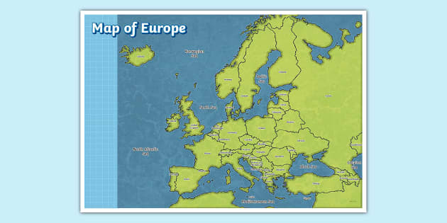
Bolster geographical knowledge with this map of Europe for kids
Are you teaching your pupils about Europe? Use this handy map of Europe for kids to help your students remember the names of all the different European countries.
Related Searches
 europe map
europe
world map
european countries
blank map of europe
map of world
map of the world
map of the europe
europe landmarks
greece geography
greece
map of spain
map of uk
map of south america
travelling around
contrasting places
europe maps and plans
people and other lands
europe map
europe
world map
european countries
blank map of europe
map of world
map of the world
map of the europe
europe landmarks
greece geography
greece
map of spain
map of uk
map of south america
travelling around
contrasting places
europe maps and plans
people and other lands
- Ratings & Reviews
- Curriculum Links
- Make a Request
- Resource Updates
-
Lovely, although Kaliningrad seems to have detached itself from Poland and floated up to Estonia!
-
Hello adavies22,
Thanks for spotting this. I'll let the design team know right away and get this looked at. 4 years ago
✔ Thank you for your feedback -
Hi there adavies22,
Thank you for spotting this mistake! Our lovely teacher and design teams have solved the issue and the new version is now available to download. I hope you like it! 4 years ago
✔ Thank you for your feedback
-
-
Just noticed this map is missing Kaliningrad (under Lithuania) thanks
-
Hi trips1,
Thanks for spotting this! We'll let our resource creation team know right away and get this fixed :) 5 years ago
✔ Thank you for your feedback -
Hi there trips1,
Our lovely resource creation team have completed this and emailed the new resource to you. It will be available on our website soon! I hope you like it! 5 years ago
✔ Thank you for your feedback
-
-
Love the resource but 'Italy' is spelt wrong on the main version, it has 2 t's! a student pointed that out to me!
-
Hi Bassetthound,
Thank you so much for letting us know about this one. I'll get this corrected right away! 8 years ago
✔ Thank you for your feedback -
Hi there Bassetthound,
Thank you for spotting this! Our lovely teacher and design teams have fixed the mistake and emailed the corrected resource to you! It will also be updated on the website very soon - I hope you find it useful! 8 years ago
✔ Thank you for your feedback
-
-
This is just what I was looking for! Could you make a blank black and white version, please? Want the children to draw, colour and label as they learn about different rivers and mountains in Europe in our next topic. Thank you!
-
Good afternoon chocoholiclou,
Thanks for your lovely request - I'll ask our design team to take a look and see if we can make these changes for you :) 6 years ago
✔ Thank you for your feedback -
Hi there chocoholiclou,
Our lovely resource creation team have completed this and emailed the new resource to you, I hope you find it useful! It will also be available for download within 48 hours, and you can find it either as a new resource, or under 'Alternative versions' above. 6 years ago
✔ Thank you for your feedback
-
- Twinkl updated the Main Version on 2 days ago
- Twinkl added Black and White Editable Version 2 years ago
- Twinkl added a3 black and white 6 years ago
- Twinkl added eco black and white version a4 6 years ago
- Twinkl added a3 version 8 years ago
- Twinkl added 4xa4 version 8 years ago
- Twinkl added 2xa4 version 8 years ago
Bolster geographical knowledge with this map of Europe for kids
Are you teaching your pupils about Europe? Use this handy map of Europe for kids to help your students remember the names of all the different European countries.
Once you've downloaded this resource, you'll be provided with a large map displaying the name of each country. This resource is compatible to be printed in A2, A3 or A4 sizing to cater for your lesson ideas. Whether you're creating a bright and colourful display for your classroom, or providing a copy for kids to stick into their Geography books, this reusable resource has you covered.
With a simple and colourful design, the map lists each country on the European continent, as well as the oceans and seas that surround it. It's ideal for a topical classroom display you can use as part of a Geography topic, although it'll also look great in bedrooms and hallways.
To learn more about the UK, explore this Map of the UK with Cities. Here, you'll discover a useful poster featuring the labels for each significant city. This includes the capital city for each UK nation (England, Scotland, Wales and Northern Ireland), along with labels for large cities such as Manchester, Liverpool and Leeds. Perfect to use to help children learn more about the world around them.
More resources on Europe for your pupils:
If you think your students will enjoy this wonderful map of Europe for kids, why not try checking out some of our related resources? We've designed a variety of resources to enhance your lessons on reading and understanding maps and our surrounding environments.
- Europe Map Labelling Activity Worksheet- Test how well your kids know Europe using these Labelling Worksheets. Here, your kids will be provided with a blank map of Europe and accompanying labels to stick on.
- Introduction to Europe Teaching Pack - If you're looking to learn more about Europe, then this wonderful Teaching Pack is a great place to start.
- Map of Europe with Flags - To expand Geography skills in your lessons, provide your pupils with this useful Map of Europe with Flags Poster. Each country on this map is labelled with their flag, meaning children will learn all about the flags for each country.
Did you know? Europe is a continent located in the Northern Hemisphere containing countries such as the UK, Italy, Russia and Germany. In fact, Europe contains over 44 countries altogether and has a population of over 740 million people. In such as vast area, over 200 different languages are spoken including English, Spanish, German, French, Irish (Gaeilge), and much more.
Top 5 biggest countries in Europe by area
The top 5 biggest countries in Europe by area are as follows:
- Russia - 1,533,800 sq. miles
- Ukraine - 233,062 sq. miles
- France - 213,011 sq. miles
- Spain - 192,476 sq. miles
- Sweden - 173,860 sq. miles