Tehachapi Pass
Last updated| Tehachapi Pass | |
|---|---|
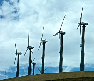
 The Tehachapi Pass Wind Farm, as seen from California State Route 58 | |
| Elevation | 3,771 ft (1,149 m) [1] |
| Traversed by | Union Pacific Railroad Future California High-Speed Rail |
| Location | Kern County, California |
| Range | Tehachapi Mountains / Sierra Nevada |
| Coordinates | 35°06′08″N118°16′58″W / 35.10222°N 118.28278°W |
 Location in California  Tehachapi Pass (California) | |
Tehachapi Pass (Kawaiisu: Tihachipia, meaning "hard climb") [2] [3] is a mountain pass crossing the Tehachapi Mountains in Kern County, California. Traditionally, the pass marks the northeast end of the Tehachapis and the south end of the Sierra Nevada range.
Contents
The route is a principal connector between the San Joaquin Valley and the Mojave Desert. The Native American Kitanemuk people used the pass as a trade route before the American settlement of the region in the 19th century. The main line of the former Southern Pacific Railroad opened though the pass in 1876; [4] the tracks are now owned by the Union Pacific Railroad and shared with BNSF Railway as the Mojave Subdivision. U.S. Route 466 was built in the 1930s, and the road is now State Route 58. The Pass is also the route of the planned California High-Speed Rail line.
The Tehachapi Mountains are also crossed by Tejon Pass at the southwest end of the range.
Nomenclature
The precise meaning of the name Tehachapi Pass is often a source of confusion. Technically (i.e., as noted on USGS topographic maps), the name refers to the narrowest part of the canyon on the eastern approach to the summit (as at San Gorgonio Pass), where the elevation is about 3,771 feet (1,149 m). [1] The actual high point is just east of the town of Tehachapi, at an elevation (on the railroad next to Tehachapi Boulevard) of 4,031 feet (1,229 m). [1] The highway sign refers to this location as Tehachapi Summit. However, the term Tehachapi Pass is routinely used to refer to both this location and the approaches on either side.
Features

The mountain pass acts as a venturi effect to air moving between ocean and desert, increasing wind speed. [5]
The area east and south of the pass is home to the Tehachapi Pass Wind Farm, and to the west is Alta Wind Energy Center, some of California's larger wind farms.
The railroad landmark known as the Tehachapi Loop is about 18 miles (29 km) west of the summit. The pass is also a proposed route for the California High-Speed Rail line between Palmdale and Bakersfield. [6]
See also
Related Research Articles

California is a U.S. state on the western coast of North America. Covering an area of 163,696 sq mi (423,970 km2), California is among the most geographically diverse states. The Sierra Nevada, the fertile farmlands of the Central Valley, and the arid Mojave Desert of the south are some of the major geographic features of this U.S. state. It is home to some of the world's most exceptional trees: the tallest, most massive, and oldest. It is also home to both the highest and lowest points in the 48 contiguous states. The state is generally divided into Northern and Southern California, although the boundary between the two is not well defined. San Francisco is decidedly a Northern California city and Los Angeles likewise a Southern California one, but areas in between do not often share their confidence in geographic identity. The US Geological Survey defines the geographic center of California about 7.1 miles driving distance from the United States Forest Service office in the Northern Californian city of North Fork, California.

Tehachapi is a city in Kern County, California, United States, in the Tehachapi Mountains, at an elevation of 3,970 feet (1,210 m), between the San Joaquin Valley and the Mojave Desert. Tehachapi is 35 miles (56 km) east-southeast of Bakersfield, and 20 miles (32 km) west of Mojave. According to the United States Census Bureau, the city has a total area of 10 square miles (26 km2) and a population of 14,414. The Tehachapi area is known for the nearby Tehachapi Loop, the Pacific Crest Trail and for the excellent conditions for the aerial sport of gliding.

State Route 14 (SR 14) is a north–south state highway in the U.S. state of California that connects Los Angeles to the northern Mojave Desert. The southern portion of the highway is signed as the Antelope Valley Freeway. Its southern terminus is at Interstate 5 in the Los Angeles neighborhoods of Granada Hills and Sylmar just immediately to the south of the border of the city of Santa Clarita. SR 14's northern terminus is at U.S. Route 395 (US 395) near Inyokern. Legislatively, the route extends south of I-5 to SR 1 in the Pacific Palisades area of Los Angeles; however, the portion south of the junction with I-5 has not been constructed. The southern part of the constructed route is a busy commuter freeway serving and connecting the cities of Santa Clarita, Palmdale, and Lancaster to the rest of the Greater Los Angeles area. The northern portion, from Vincent to US 395, is legislatively named the Aerospace Highway, as the highway serves Edwards Air Force Base, once one of the primary landing strips for NASA's Space Shuttle, as well as the Naval Air Weapons Station China Lake that supports military aerospace research, development and testing. This section is rural, following the line between the hot Mojave desert and the forming Sierra Nevada mountain range. Most of SR 14 is loosely paralleled by a rail line originally built by the Southern Pacific Railroad, and was once the primary rail link between Los Angeles and Northern California. While no longer a primary rail line, the southern half of this line is now used for the Antelope Valley Line of the Metrolink commuter rail system.
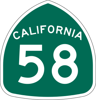
State Route 58 is a major east-west state highway in the U.S. state of California that runs across the Coast Ranges, the southern San Joaquin Valley, the Tehachapi Mountains, which border the southern Sierra Nevada, and the Mojave Desert. It runs between U.S. Route 101 near Santa Margarita and Interstate 15 in Barstow. It has junctions with Interstate 5 near Buttonwillow, State Route 99 in Bakersfield, State Route 202 in Tehachapi, State Route 14 near Mojave, and U.S. Route 395 at Kramer Junction. SR 58 also provides access to Edwards Air Force Base. At various points it is known as the Calf Canyon Highway, Carrisa Highway, Bakersfield-McKittrick Highway, Rosa Parks Highway, Westside Parkway, Barstow-Bakersfield Highway, Bakersfield Tehachapi Highway, Kern County Korean War Veterans Memorial Highway, and Mojave-Barstow Highway.

The Tehachapi Mountains are a mountain range in the Transverse Ranges system of California in the Western United States. The range extends for approximately 40 miles (64 km) in southern Kern County and northwestern Los Angeles County and form part of the boundary between the San Joaquin Valley and the Mojave Desert.

The Tehachapi Loop is a 3,779-foot-long spiral, or helix, on the Union Pacific Railroad Mojave Subdivision through Tehachapi Pass, of the Tehachapi Mountains in Kern County, south-central California. The line connects Bakersfield and the San Joaquin Valley to Mojave in the Mojave Desert.
Altamont Pass, formerly Livermore Pass, is a low mountain pass in the Diablo Range of Northern California between Livermore in the Livermore Valley and Tracy in the San Joaquin Valley. The name is actually applied to two distinct but nearby crossings of the range. The lower of the two, at an elevation of 741 ft (226 m), carries two railroad rights-of-way (ROWs) and Altamont Pass Road, part of the old Lincoln Highway and the original alignment of US 50 before it was bypassed c. 1937. The bypass route travels over the higher summit, at 1,009 ft (308 m), and now carries Interstate 580, a major regional highway heavily congested by Central Valley suburbanization.

Cajon Pass is a mountain pass between the San Bernardino Mountains to the east and the San Gabriel Mountains to the west in Southern California. Created by the movements of the San Andreas Fault, it has an elevation of 3,777 ft (1,151 m). Located in the Mojave Desert, the pass is an important link from the Greater San Bernardino Area to the Victor Valley, and northeast to Las Vegas. The Cajon Pass area is on the Pacific Crest Trail.

Soledad Canyon is a long narrow canyon/valley located in Los Angeles County, California between the cities of Palmdale and Santa Clarita. It is a part of the Santa Clara River Valley, and extends from the top of Soledad Pass to the open plain of the valley in Santa Clarita. The upstream section of the Santa Clara River runs through it.

Caliente is an unincorporated community in Kern County, California. It is located 22 miles (35 km) east-southeast of Bakersfield, at an elevation of 1,312 feet (400 m).

The San Gorgonio Pass, or Banning Pass, is a 2,600 ft (790 m) elevation gap on the rim of the Great Basin between the San Bernardino Mountains to the north and the San Jacinto Mountains to the south. The pass was formed by the San Andreas Fault, a major transform fault between the Pacific plate and the North American plate that is slipping at a rate of 7.2 ±2.8 mm/year. The tall mountain ranges on either side of the pass result in the pass being a transitional zone from a Mediterranean climate west of the pass, to a Desert climate east of the pass. This also makes the pass area one of the windiest places in the United States, and why it is home to the San Gorgonio Pass wind farm.
Siskiyou Pass is a historic mountain pass in the Siskiyou Mountains of Jackson County. It is the most used pass in the U.S. state of Oregon. The Hudson's Bay Company (HBC) made the Siskiyou Trail over the pass before pioneers traversed it with their wagons, while still later it evolved into a stage road, a railroad line, and a highway route. The name Siskiyou is believed to be derived from Cree, meaning "bob-tailed horse". Siskiyou Pass is west of the summit of Interstate 5, which is known as Siskiyou Summit.

U.S. Route 395 (US 395) is a United States Numbered Highway, stretching from Hesperia, California to the Canadian border in Laurier, Washington. The California portion of US 395 is a 557-mile (896 km) route which traverses from Interstate 15 (I-15) in Hesperia, north to the Oregon state line in Modoc County near Goose Lake. The route clips into Nevada, serving the cities Carson City and Reno, before returning to California.
Oak Creek Pass is a mountain pass through the Tehachapi Mountains, in Kern County, California. The road across it connects the City of Tehachapi with the Mojave Desert.

Kern County’s transportation system was quoted as the “unseen industry.” Located at the southern end of the San Joaquin Valley, the county is at a prime location to ship goods west to the central coast, south to ports in Los Angeles, and east to corridors that connect to the rest of the country. It is also on major corridors that link to all northern points.
Tejon Creek, originally in Spanish Arroyo de Tejon, is a stream in Kern County, California. Its headwaters are located on the western slopes of the Tehachapi Mountains, and it flows northwest into the southern San Joaquin Valley.
The Old Tejon Pass is a mountain pass in the Tehachapi Mountains linking Southern and Central California.

Soledad Pass, elevation 3,209 ft (978 m), is a mountain pass in northern Los Angeles County, California.

The Tehachapi Wind Resource Area (TWRA) is a large wind resource area along the foothills of the Sierra Nevada and Tehachapi Mountains in California. It is the largest wind resource area in California, encompassing an area of approximately 800 sq mi (2,100 km2) and producing a combined 3,507 MW of renewable electricity between its 5 independent wind farms.

The Mojave Subdivision refers to a series of railway lines in California. The primary route crosses the Tehachapi Pass and features the Tehachapi Loop, connecting Bakersfield to the Mojave Desert. East of Mojave, the line splits with the Union Pacific Railroad portion continuing south to Palmdale and Colton over the Cajon Pass and the BNSF Railway owned segment running east to Barstow. Both companies generally share trackage rights across the lines.
References
- 1 2 3 "USGS 7.5 minute topographic map". USGS . Retrieved 2013-05-31.
- ↑ "Visitor Guide: What does 'Tehachapi' mean?". Tehachapi News. 2017-05-18. Archived from the original on Oct 5, 2023.
- ↑ Mathews, Joe (2016-02-11). "Meet the Toughest Mountains in California | Connecting California". Zócalo Public Square. Archived from the original on Oct 5, 2023.
- ↑ "Tehachapi Pass Railroad Line". American Society of Civil Engineers. Archived from the original on Sep 21, 2020. Retrieved 22 October 2020.
- ↑ "Why Tehachapi Pass? / Pioneers of the Wind / Hike A Mile or Two - Thousand Historical Marker". www.hmdb.org. Archived from the original on 19 October 2020.
- ↑ Vartabedian, Ralph (29 February 2020). "Bullet train plan for Tehachapi passage would cost $18.1 billion over 82 miles". Los Angeles Times. Retrieved 22 October 2020.
| Mountains |
| |||||||||||
|---|---|---|---|---|---|---|---|---|---|---|---|---|
| Passes | ||||||||||||
| Rivers | ||||||||||||
| Lakes | ||||||||||||
| Protected areas |
| |||||||||||
| Communities | ||||||||||||
| Ski areas | ||||||||||||
| Trails | ||||||||||||

| International | |
|---|---|
| National | |
Text is available under the CC BY-SA 4.0 license; additional terms may apply.
Images, videos and audio are available under their respective licenses.