Greve Strand
You can help expand this article with text translated from the corresponding article in Danish. (December 2023) Click [show] for important translation instructions.
|
Greve Strand | |
|---|---|
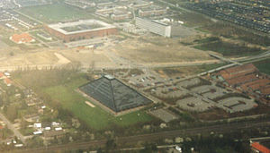
 Aerial view of Hundige parish | |
 | |
| Coordinates: 55°34′N 12°18′E / 55.567°N 12.300°E | |
| Country | Denmark |
| Region | Zealand (Sjælland) |
| Municipality | Greve |
| Government | |
| • Mayor | Pernille Beckmann |
| Area | |
| • Total | 21.9 km2 (8.5 sq mi) |
| Population (1. January 2023)[1] | |
| • Total | 44,119 |
| • Density | 2,000/km2 (5,200/sq mi) |
| Time zone | UTC+1 (Central Europe Time) |
| • Summer (DST) | UTC+2 |
Greve Strand (commonly also known simply as Greve) is a Danish town, seat of the Greve Municipality, in the Region Sjælland. Its population is 44,119 (1. January 2023).[1]
History[edit]
Until the 1960s, the area was primarily agricultural: most businesses in town were concentrated along the coastal road "Strandvejen".
Geography[edit]
Greve Strand is located on the eastern side of the Zealand island, not too far (approx. 25 km) from Copenhagen and is a part of its urban area.
Notable people[edit]
- Max Jørgensen (1923 in Kildebrønde – 1992) a Danish cyclist, competed in the team pursuit at the 1948 Summer Olympics
- Rune Ohm (born 1980 in Greve) a Danish handball player
- Mie Lacota (born 1988 in Greve) a professional road and track cyclist
- Nadia Offendal (born 1994 in Greve) a Danish handball player
- Andreas Bruus (born 1999 in Greve) a Danish footballer
- Amalie Magelund (born 2000) a Danish badminton player, lives in Greve
See also[edit]
References[edit]
- ^ a b BY3: Population 1. January by urban areas, area and population density The Mobile Statbank from Statistics Denmark
External links[edit]
![]() Media related to Greve Strand at Wikimedia Commons
Media related to Greve Strand at Wikimedia Commons
55°34′56″N 12°17′20″E / 55.58222°N 12.28889°E
