Seismic magnitude scales
Last updated| Part of a series on |
| Earthquakes |
|---|
 |
Seismic magnitude scales are used to describe the overall strength or "size" of an earthquake. These are distinguished from seismic intensity scales that categorize the intensity or severity of ground shaking (quaking) caused by an earthquake at a given location. Magnitudes are usually determined from measurements of an earthquake's seismic waves as recorded on a seismogram. Magnitude scales vary based on what aspect of the seismic waves are measured and how they are measured. Different magnitude scales are necessary because of differences in earthquakes, the information available, and the purposes for which the magnitudes are used.
Contents
- Earthquake magnitude and ground-shaking intensity
- Magnitude scales
- "Richter" magnitude scale
- Other "local" magnitude scales
- Body-wave magnitude scales
- Surface-wave magnitude scales
- Moment magnitude and energy magnitude scales
- Energy class (K-class) scale
- Tsunami magnitude scales
- Duration and Coda magnitude scales
- Macroseismic magnitude scales
- Other magnitude scales
- See also
- Citations
- General and cited sources
- External links
Earthquake magnitude and ground-shaking intensity

The Earth's crust is stressed by tectonic forces. When this stress becomes great enough to rupture the crust, or to overcome the friction that prevents one block of crust from slipping past another, energy is released, some of it in the form of various kinds of seismic waves that cause ground-shaking, or quaking.
Magnitude is an estimate of the relative "size" or strength of an earthquake, and thus its potential for causing ground-shaking. It is "approximately related to the released seismic energy." [1]
Intensity refers to the strength or force of shaking at a given location, and can be related to the peak ground velocity. With an isoseismal map of the observed intensities (see illustration) an earthquake's magnitude can be estimated from both the maximum intensity observed (usually but not always near the epicenter), and from the extent of the area where the earthquake was felt. [2]
The intensity of local ground-shaking depends on several factors besides the magnitude of the earthquake, [3] one of the most important being soil conditions. For instance, thick layers of soft soil (such as fill) can amplify seismic waves, often at a considerable distance from the source, while sedimentary basins will often resonate, increasing the duration of shaking. This is why, in the 1989 Loma Prieta earthquake, the Marina district of San Francisco was one of the most damaged areas, though it was nearly 100 km from the epicenter. [4] Geological structures were also significant, such as where seismic waves passing under the south end of San Francisco Bay reflected off the base of the Earth's crust towards San Francisco and Oakland. A similar effect channeled seismic waves between the other major faults in the area. [5]
Magnitude scales

An earthquake radiates energy in the form of different kinds of seismic waves, whose characteristics reflect the nature of both the rupture and the earth's crust the waves travel through. [6] Determination of an earthquake's magnitude generally involves identifying specific kinds of these waves on a seismogram, and then measuring one or more characteristics of a wave, such as its timing, orientation, amplitude, frequency, or duration. [7] Additional adjustments are made for distance, kind of crust, and the characteristics of the seismograph that recorded the seismogram.
The various magnitude scales represent different ways of deriving magnitude from such information as is available. All magnitude scales retain the logarithmic scale as devised by Charles Richter, and are adjusted so the mid-range approximately correlates with the original "Richter" scale. [8]
Most magnitude scales are based on measurements of only part of an earthquake's seismic wave-train, and therefore are incomplete. This results in systematic underestimation of magnitude in certain cases, a condition called saturation. [9]
Since 2005 the International Association of Seismology and Physics of the Earth's Interior (IASPEI) has standardized the measurement procedures and equations for the principal magnitude scales, ML , Ms , mb , mB and mbLg . [10]
"Richter" magnitude scale
The first scale for measuring earthquake magnitudes, developed in 1935 by Charles F. Richter and popularly known as the "Richter" scale, is actually the Local magnitude scale, label ML or ML. [11] Richter established two features now common to all magnitude scales.
- First, the scale is logarithmic, so that each unit represents a ten-fold increase in the amplitude of the seismic waves. [12] As the energy of a wave is proportional to A1.5, where A denotes the amplitude, each unit of magnitude represents a 101.5≈32-fold increase in the seismic energy (strength) of an earthquake. [13]
- Second, Richter arbitrarily defined the zero point of the scale to be where an earthquake at a distance of 100 km makes a maximum horizontal displacement of 0.001 millimeters (1 µm, or 0.00004 in.) on a seismogram recorded with a Wood-Anderson torsion seismograph. [14] Subsequent magnitude scales are calibrated to be approximately in accord with the original "Richter" (local) scale around magnitude 6. [15]
All "Local" (ML) magnitudes are based on the maximum amplitude of the ground shaking, without distinguishing the different seismic waves. They underestimate the strength:
- of distant earthquakes (over ~600 km) because of attenuation of the S-waves,
- of deep earthquakes because the surface waves are smaller, and
- of strong earthquakes (over M ~7) because they do not take into account the duration of shaking.
The original "Richter" scale, developed in the geological context of Southern California and Nevada, was later found to be inaccurate for earthquakes in the central and eastern parts of the continent (everywhere east of the Rocky Mountains) because of differences in the continental crust. [16] All these problems prompted the development of other scales.
Most seismological authorities, such as the United States Geological Survey, report earthquake magnitudes above 4.0 as moment magnitude (below), which the press describes as "Richter magnitude". [17]
Other "local" magnitude scales
Richter's original "local" scale has been adapted for other localities. These may be labelled "ML", or with a lowercase "l", either Ml, or Ml. [18] (Not to be confused with the Russian surface-wave MLH scale. [19] ) Whether the values are comparable depends on whether the local conditions have been adequately determined and the formula suitably adjusted. [20]
Japan Meteorological Agency magnitude scale
In Japan, for shallow (depth < 60 km) earthquakes within 600 km, the Japanese Meteorological Agency calculates [21] a magnitude labeled MJMA, MJMA, or MJ. (These should not be confused with moment magnitudes JMA calculates, which are labeled Mw(JMA) or M(JMA), nor with the Shindo intensity scale.) JMA magnitudes are based (as typical with local scales) on the maximum amplitude of the ground motion; they agree "rather well" [22] with the seismic moment magnitude Mw in the range of 4.5 to 7.5, [23] but underestimate larger magnitudes.
Body-wave magnitude scales
Body-waves consist of P-waves that are the first to arrive (see seismogram), or S-waves, or reflections of either. Body-waves travel through rock directly. [24]
mB scale
The original "body-wave magnitude" – mB or mB (uppercase "B") – was developed by Gutenberg 1945c and Gutenberg & Richter 1956 [25] to overcome the distance and magnitude limitations of the ML scale inherent in the use of surface waves. mB is based on the P- and S-waves, measured over a longer period, and does not saturate until around M 8. However, it is not sensitive to events smaller than about M 5.5. [26] Use of mB as originally defined has been largely abandoned, [27] now replaced by the standardized mBBB scale. [28]
mb scale
The mb or mb scale (lowercase "m" and "b") is similar to mB , but uses only P-waves measured in the first few seconds on a specific model of short-period seismograph. [29] It was introduced in the 1960s with the establishment of the World-Wide Standardized Seismograph Network (WWSSN); the short period improves detection of smaller events, and better discriminates between tectonic earthquakes and underground nuclear explosions. [30]
Measurement of mb has changed several times. [31] As originally defined by Gutenberg (1945c) mb was based on the maximum amplitude of waves in the first 10 seconds or more. However, the length of the period influences the magnitude obtained. Early USGS/NEIC practice was to measure mb on the first second (just the first few P-waves [32] ), but since 1978 they measure the first twenty seconds. [33] The modern practice is to measure short-period mb scale at less than three seconds, while the broadband mBBB scale is measured at periods of up to 30 seconds. [34]
mbLg scale
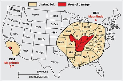
The regional mbLg scale – also denoted mb_Lg, mbLg, MLg (USGS), Mn, and mN – was developed by Nuttli (1973) for a problem the original ML scale could not handle: all of North America east of the Rocky Mountains. The ML scale was developed in southern California, which lies on blocks of oceanic crust, typically basalt or sedimentary rock, which have been accreted to the continent. East of the Rockies the continent is a craton, a thick and largely stable mass of continental crust that is largely granite, a harder rock with different seismic characteristics. In this area the ML scale gives anomalous results for earthquakes which by other measures seemed equivalent to quakes in California.
Nuttli resolved this by measuring the amplitude of short-period (~1 sec.) Lg waves, [35] a complex form of the Love wave which, although a surface wave, he found provided a result more closely related to the mb scale than the Ms scale. [36] Lg waves attenuate quickly along any oceanic path, but propagate well through the granitic continental crust, and MbLg is often used in areas of stable continental crust; it is especially useful for detecting underground nuclear explosions. [37]
Surface-wave magnitude scales
Surface waves propagate along the Earth's surface, and are principally either Rayleigh waves or Love waves. [38] For shallow earthquakes the surface waves carry most of the energy of the earthquake, and are the most destructive. Deeper earthquakes, having less interaction with the surface, produce weaker surface waves.
The surface-wave magnitude scale, variously denoted as Ms, MS, and Ms, is based on a procedure developed by Beno Gutenberg in 1942 [39] for measuring shallow earthquakes stronger or more distant than Richter's original scale could handle. Notably, it measured the amplitude of surface waves (which generally produce the largest amplitudes) for a period of "about 20 seconds". [40] The Ms scale approximately agrees with ML at ~6, then diverges by as much as half a magnitude. [41] A revision by Nuttli (1983), sometimes labeled MSn, [42] measures only waves of the first second.
A modification – the "Moscow-Prague formula" – was proposed in 1962, and recommended by the IASPEI in 1967; this is the basis of the standardized Ms20 scale (Ms_20, Ms(20)). [43] A "broad-band" variant (Ms_BB, Ms(BB)) measures the largest velocity amplitude in the Rayleigh-wave train for periods up to 60 seconds. [44] The MS7 scale used in China is a variant of Ms calibrated for use with the Chinese-made "type 763" long-period seismograph. [45]
The MLH scale used in some parts of Russia is actually a surface-wave magnitude. [46]
Moment magnitude and energy magnitude scales
Other magnitude scales are based on aspects of seismic waves that only indirectly and incompletely reflect the force of an earthquake, involve other factors, and are generally limited in some respect of magnitude, focal depth, or distance. The moment magnitude scale – Mw or Mw – developed by seismologists Thomas C. Hanks and Hiroo Kanamori, [47] is based on an earthquake's seismic moment , M0, a measure of how much work an earthquake does in sliding one patch of rock past another patch of rock. [48] Seismic moment is measured in Newton-meters (Nm or N·m) in the SI system of measurement, or dyne-centimeters (dyn-cm; 1 dyn-cm = 10−7 Nm) in the older CGS system. In the simplest case the moment can be calculated knowing only the amount of slip, the area of the surface ruptured or slipped, and a factor for the resistance or friction encountered. These factors can be estimated for an existing fault to determine the magnitude of past earthquakes, or what might be anticipated for the future. [49]
An earthquake's seismic moment can be estimated in various ways, which are the bases of the Mwb, Mwr, Mwc, Mww, Mwp, Mi, and Mwpd scales, all subtypes of the generic Mw scale. See Moment magnitude scale § Subtypes for details.
Seismic moment is considered the most objective measure of an earthquake's "size" in regard of total energy. [50] However, it is based on a simple model of rupture, and on certain simplifying assumptions; it does not account for the fact that the proportion of energy radiated as seismic waves varies among earthquakes. [51]
Much of an earthquake's total energy as measured by Mw is dissipated as friction (resulting in heating of the crust). [52] An earthquake's potential to cause strong ground shaking depends on the comparatively small fraction of energy radiated as seismic waves, and is better measured on the energy magnitude scale, Me. [53] The proportion of total energy radiated as seismic waves varies greatly depending on focal mechanism and tectonic environment; [54] Me and Mw for very similar earthquakes can differ by as much as 1.4 units. [55]
Despite the usefulness of the Me scale, it is not generally used due to difficulties in estimating the radiated seismic energy. [56]
Two earthquakes differing greatly in the damage done
In 1997 there were two large earthquakes off the coast of Chile. The magnitude of the first, in July, was estimated at Mw 6.9, but was barely felt, and only in three places. In October a Mw 7.1 quake in nearly the same location, but twice as deep and on a different kind of fault, was felt over a broad area, injured over 300 people, and destroyed or seriously damaged over 10,000 houses. As can be seen in the table below, this disparity of damage done is not reflected in either the moment magnitude (Mw ) nor the surface-wave magnitude (Ms ). Only when the magnitude is measured on the basis of the body-wave (mb ) or the seismic energy (Me ) is there a difference comparable to the difference in damage.
| Date | ISC # | Lat. | Long. | Depth | Damage | Ms | Mw | mb | Me | Type of fault |
|---|---|---|---|---|---|---|---|---|---|---|
| 6 July 1997 | 1035633 | −30.06 | −71.87 | 23 km | Barely felt | 6.5 | 6.9 | 5.8 | 6.1 | interplate-thrust |
| 15 Oct. 1997 | 1047434 | −30.93 | −71.22 | 58 km | Extensive | 6.8 | 7.1 | 6.8 | 7.5 | intraslab-normal |
| Difference: | 0.3 | 0.2 | 1.0 | 1.4 | ||||||
Rearranged and adapted from Table 1 in Choy, Boatwright & Kirby 2001, p. 13. Seen also in IS 3.6 2012, p. 7.
Energy class (K-class) scale
K (from the Russian word класс, "class", in the sense of a category [57] ) is a measure of earthquake magnitude in the energy class or K-class system, developed in 1955 by Soviet seismologists in the remote Garm (Tajikistan) region of Central Asia; in revised form it is still used for local and regional quakes in many states formerly aligned with the Soviet Union (including Cuba). Based on seismic energy (K = log ES, in Joules), difficulty in implementing it using the technology of the time led to revisions in 1958 and 1960. Adaptation to local conditions has led to various regional K scales, such as KF and KS. [58]
K values are logarithmic, similar to Richter-style magnitudes, but have a different scaling and zero point. K values in the range of 12 to 15 correspond approximately to M 4.5 to 6. [59] M(K), M(K), or possibly MK indicates a magnitude M calculated from an energy class K. [60]
Tsunami magnitude scales
Earthquakes that generate tsunamis generally rupture relatively slowly, delivering more energy at longer periods (lower frequencies) than generally used for measuring magnitudes. Any skew in the spectral distribution can result in larger, or smaller, tsunamis than expected for a nominal magnitude. [61] The tsunami magnitude scale, Mt, is based on a correlation by Katsuyuki Abe of earthquake seismic moment (M0 ) with the amplitude of tsunami waves as measured by tidal gauges. [62] Originally intended for estimating the magnitude of historic earthquakes where seismic data is lacking but tidal data exist, the correlation can be reversed to predict tidal height from earthquake magnitude. [63] (Not to be confused with the height of a tidal wave, or run-up, which is an intensity effect controlled by local topography.) Under low-noise conditions, tsunami waves as little as 5 cm can be predicted, corresponding to an earthquake of M ~6.5. [64]
Another scale of particular importance for tsunami warnings is the mantle magnitude scale, Mm. [65] This is based on Rayleigh waves that penetrate into the Earth's mantle, and can be determined quickly, and without complete knowledge of other parameters such as the earthquake's depth.
Duration and Coda magnitude scales
Md designates various scales that estimate magnitude from the duration or length of some part of the seismic wave-train. This is especially useful for measuring local or regional earthquakes, both powerful earthquakes that might drive the seismometer off-scale (a problem with the analog instruments formerly used) and preventing measurement of the maximum wave amplitude, and weak earthquakes, whose maximum amplitude is not accurately measured. Even for distant earthquakes, measuring the duration of the shaking (as well as the amplitude) provides a better measure of the earthquake's total energy. Measurement of duration is incorporated in some modern scales, such as Mwpd and mBc . [66]
Mc scales usually measure the duration or amplitude of a part of the seismic wave, the coda. [67] For short distances (less than ~100 km) these can provide a quick estimate of magnitude before the quake's exact location is known. [68]
Macroseismic magnitude scales
Magnitude scales generally are based on instrumental measurement of some aspect of the seismic wave as recorded on a seismogram. Where such records do not exist, magnitudes can be estimated from reports of the macroseismic events such as described by intensity scales. [69]
One approach for doing this (developed by Beno Gutenberg and Charles Richter in 1942 [70] ) relates the maximum intensity observed (presumably this is over the epicenter), denoted I0 (capital I with a subscripted zero), to the magnitude. It has been recommended that magnitudes calculated on this basis be labeled Mw(I0), [71] but are sometimes labeled with a more generic Mms.
Another approach is to make an isoseismal map showing the area over which a given level of intensity was felt. The size of the "felt area" can also be related to the magnitude (based on the work of Frankel 1994 and Johnston 1996). While the recommended label for magnitudes derived in this way is M0(An), [72] the more commonly seen label is Mfa. [73] A variant, MLa, adapted to California and Hawaii, derives the Local magnitude (ML) from the size of the area affected by a given intensity. [74] MI (upper-case letter "I", distinguished from the lower-case letter in Mi) has been used for moment magnitudes estimated from isoseismal intensities calculated per Johnston 1996. [75]
Peak ground velocity (PGV) and Peak ground acceleration (PGA) are measures of the force that causes destructive ground shaking. [76] In Japan, a network of strong-motion accelerometers provides PGA data that permits site-specific correlation with different magnitude earthquakes. This correlation can be inverted to estimate the ground shaking at that site due to an earthquake of a given magnitude at a given distance. From this a map showing areas of likely damage can be prepared within minutes of an actual earthquake. [77]
Other magnitude scales
Many earthquake magnitude scales have been developed or proposed, with some never gaining broad acceptance and remaining only as obscure references in historical catalogs of earthquakes. Other scales have been used without a definite name, often referred to as "the method of Smith (1965)" (or similar language), with the authors often revising their method. On top of this, seismological networks vary on how they measure seismograms. Where the details of how a magnitude has been determined are unknown, catalogs will specify the scale as unknown (variously Unk, Ukn, or UK). In such cases, the magnitude is considered generic and approximate.
An Mh ("magnitude determined by hand") label has been used where the magnitude is too small or the data too poor (typically from analog equipment) to determine a Local magnitude, or multiple shocks or cultural noise complicates the records. The Southern California Seismic Network uses this "magnitude" where the data fail the quality criteria. [78]
A special case is the Seismicity of the Earth catalog of Gutenberg & Richter (1954). Hailed as a milestone as a comprehensive global catalog of earthquakes with uniformly calculated magnitudes, [79] they never published the full details of how they determined those magnitudes. [80] Consequently, while some catalogs identify these magnitudes as MGR, others use UK (meaning "computational method unknown"). [81] Subsequent study found many of the Ms values to be "considerably overestimated." [82] Further study has found that most of the MGR magnitudes "are basically Ms for large shocks shallower than 40 km, but are basically mB for large shocks at depths of 40–60 km." [83] Gutenberg and Richter also used an italic, non-bold "M without subscript" [84] – also used as a generic magnitude, and not to be confused with the bold, non-italic M used for moment magnitude – and a "unified magnitude" m (bolding added). [85] While these terms (with various adjustments) were used in scientific articles into the 1970s, [86] they are now only of historical interest. An ordinary (non-italic, non-bold) capital "M" without subscript is often used to refer to magnitude generically, where an exact value or the specific scale used is not important.
See also
Citations
- ↑ Bormann, Wendt & Di Giacomo 2013 , p. 37. The relationship between magnitude and the energy released is complicated. See §3.1.2.5 and §3.3.3 for details.
- ↑ Bormann, Wendt & Di Giacomo 2013 , §3.1.2.1.
- ↑ Bolt 1993 , p. 164 et seq..
- ↑ Bolt 1993 , pp. 170–171.
- ↑ Bolt 1993 , p. 170.
- ↑ See Bolt 1993, Chapters 2 and 3, for a very readable explanation of these waves and their interpretation. J. R. Kayal's description of seismic waves can be found here.
- ↑ See Havskov & Ottemöller 2009 , §1.4, pp. 20–21, for a short explanation, or MNSOP-2 EX 3.1 2012 for a technical description.
- ↑ Chung & Bernreuter 1980 , p. 1.
- ↑ Bormann, Wendt & Di Giacomo 2013 , p. 18.
- ↑ IASPEI IS 3.3 2014 , pp. 2–3.
- ↑ Kanamori 1983 , p. 187.
- ↑ Richter 1935 , p. 7.
- ↑ Spence, Sipkin & Choy 1989 , p. 61.
- ↑ Richter 1935 , pp. 5; Chung & Bernreuter 1980 , p. 10. Subsequently redefined by Hutton & Boore 1987 as 10 mm of motion by an ML 3 quake at 17 km.
- ↑ Chung & Bernreuter 1980 , p. 1; Kanamori 1983 , p. 187, figure 2.
- ↑ Chung & Bernreuter 1980 , p. ix.
- ↑ The "USGS Earthquake Magnitude Policy" for reporting earthquake magnitudes to the public as formulated by the USGS Earthquake Magnitude Working Group was implemented January 18, 2002, and posted at https://earthquake.usgs.gov/aboutus/docs/020204mag_policy.php. It has since been removed; a copy is archived at the Wayback Machine, and the essential part can be found here.
- ↑ Bormann, Wendt & Di Giacomo 2013 , §3.2.4, p. 59.
- ↑ Rautian & Leith 2002 , pp. 158, 162.
- ↑ See Datasheet 3.1 in NMSOP-2 Archived 2019-08-04 at the Wayback Machine for a partial compilation and references.
- ↑ Katsumata 1996; Bormann, Wendt & Di Giacomo 2013 , §3.2.4.7, p. 78; Doi 2010.
- ↑ Bormann & Saul 2009 , p. 2478.
- ↑ See also figure 3.70 in NMSOP-2.
- ↑ Havskov & Ottemöller 2009 , p. 17.
- ↑ Bormann, Wendt & Di Giacomo 2013 , p. 37; Havskov & Ottemöller 2009 , §6.5. See also Abe 1981.
- ↑ Havskov & Ottemöller 2009 , p. 191.
- ↑ Bormann & Saul 2009 , p. 2482.
- ↑ MNSOP-2/IASPEI IS 3.3 2014 , §4.2, pp. 15–16.
- ↑ Kanamori 1983 , pp. 189, 196; Chung & Bernreuter 1980 , p. 5.
- ↑ Bormann, Wendt & Di Giacomo 2013 , pp. 37, 39; Bolt (1993 , pp. 88–93) examines this at length.
- ↑ Bormann, Wendt & Di Giacomo 2013 , p. 103.
- ↑ IASPEI IS 3.3 2014 , p. 18.
- ↑ Nuttli 1983 , p. 104; Bormann, Wendt & Di Giacomo 2013 , p. 103.
- ↑ IASPEI/NMSOP-2 IS 3.2 2013 , p. 8.
- ↑ Bormann, Wendt & Di Giacomo 2013 , §3.2.4.4. The "g" subscript refers to the granitic layer through which Lg waves propagate.Chen & Pomeroy 1980 , p. 4. See also J. R. Kayal, "Seismic Waves and Earthquake Location", here, page 5.
- ↑ Nuttli 1973 , p. 881.
- ↑ Bormann, Wendt & Di Giacomo 2013 , §3.2.4.4.
- ↑ Havskov & Ottemöller 2009 , pp. 17–19. See especially figure 1-10.
- ↑ Gutenberg 1945a; based on work by Gutenberg & Richter 1936.
- ↑ Gutenberg 1945a.
- ↑ Kanamori 1983 , p. 187.
- ↑ Stover & Coffman 1993 , p. 3.
- ↑ Bormann, Wendt & Di Giacomo 2013 , pp. 81–84.
- ↑ MNSOP-2 DS 3.1 2012 , p. 8.
- ↑ Bormann et al. 2007 , p. 118.
- ↑ Rautian & Leith 2002 , pp. 162, 164.
- ↑ Hanks, Thomas (1979). "A moment magnitude scale". Journal of Geophysical Research.
- ↑ The IASPEI standard formula for deriving moment magnitude from seismic moment is
Mw = (2/3) (log M0 – 9.1). Formula 3.68 in Bormann, Wendt & Di Giacomo 2013 , p. 125. - ↑ Anderson 2003 , p. 944.
- ↑ Havskov & Ottemöller 2009 , p. 198
- ↑ Havskov & Ottemöller 2009 , p. 198; Bormann, Wendt & Di Giacomo 2013 , p. 22.
- ↑ Bormann, Wendt & Di Giacomo 2013 , p. 23
- ↑ NMSOP-2 IS 3.6 2012 , §7.
- ↑ See Bormann, Wendt & Di Giacomo 2013 , §3.2.7.2 for an extended discussion.
- ↑ NMSOP-2 IS 3.6 2012 , §5.
- ↑ Bormann, Wendt & Di Giacomo 2013 , p. 131.
- ↑ Rautian et al. 2007 , p. 581.
- ↑ Rautian et al. 2007; NMSOP-2 IS 3.7 2012; Bormann, Wendt & Di Giacomo 2013 , §3.2.4.6.
- ↑ Bindi et al. 2011 , p. 330. Additional regression formulas for various regions can be found in Rautian et al. 2007 , Tables 1 and 2. See also IS 3.7 2012 , p. 17.
- ↑ Rautian & Leith 2002 , p. 164.
- ↑ Bormann, Wendt & Di Giacomo 2013 , §3.2.6.7, p. 124.
- ↑ Abe 1979; Abe 1989 , p. 28. More precisely, Mt is based on far-field tsunami wave amplitudes in order to avoid some complications that happen near the source. Abe 1979 , p. 1566.
- ↑ Blackford 1984 , p. 29.
- ↑ Abe 1989 , p. 28.
- ↑ Bormann, Wendt & Di Giacomo 2013 , §3.2.8.5.
- ↑ Bormann, Wendt & Di Giacomo 2013 , §3.2.4.5.
- ↑ Havskov & Ottemöller 2009 , §6.3.
- ↑ Bormann, Wendt & Di Giacomo 2013 , §3.2.4.5, pp. 71–72.
- ↑ Musson & Cecić 2012 , p. 2.
- ↑ Gutenberg & Richter 1942.
- ↑ Grünthal 2011 , p. 240.
- ↑ Grünthal 2011 , p. 240.
- ↑ "Magnitude Types | U.S. Geological Survey". www.usgs.gov. Retrieved 2024-04-06.
- ↑ Stover & Coffman 1993 , p. 3.
- ↑ Engdahl & Villaseñor 2002.
- ↑ Makris & Black 2004 , p. 1032.
- ↑ Doi 2010.
- ↑ Hutton, Woessner & Haukson 2010 , pp. 431, 433.
- ↑ NMSOP-2 IS 3.2 2013 , pp. 1–2.
- ↑ Abe 1981 , p. 74; Engdahl & Villaseñor 2002 , p. 667.
- ↑ Engdahl & Villaseñor 2002 , p. 688.
- ↑ Abe & Noguchi 1983.
- ↑ Abe 1981 , p. 72.
- ↑ Defined as "a weighted mean between MB and MS." Gutenberg & Richter 1956 , p. 1.
- ↑ "At Pasadena, a weighted mean is taken between mS as found directly from body waves, and mS, the corresponding value derived from MS ...." Gutenberg & Richter 1956 , p. 2.
- ↑ E.g., Kanamori 1977.
General and cited sources
- Abe, K. (April 1979), "Size of great earthquakes of 1837–1874 inferred from tsunami data", Journal of Geophysical Research, 84 (B4): 1561–1568, Bibcode:1979JGR....84.1561A, doi:10.1029/JB084iB04p01561 .
- Abe, K. (October 1981), "Magnitudes of large shallow earthquakes from 1904 to 1980", Physics of the Earth and Planetary Interiors, 27 (1): 72–92, Bibcode:1981PEPI...27...72A, doi:10.1016/0031-9201(81)90088-1 .
- Abe, K. (September 1989), "Quantification of tsunamigenic earthquakes by the Mt scale", Tectonophysics, 166 (1–3): 27–34, Bibcode:1989Tectp.166...27A, doi:10.1016/0040-1951(89)90202-3 .
- Abe, K; Noguchi, S. (August 1983), "Revision of magnitudes of large shallow earthquakes, 1897-1912", Physics of the Earth and Planetary Interiors, 33 (1): 1–11, Bibcode:1983PEPI...33....1A, doi:10.1016/0031-9201(83)90002-X .
- Anderson, J. G. (2003), "Chapter 57: Strong-Motion Seismology", International Handbook of Earthquake & Engineering Seismology, Part B, pp. 937–966, ISBN 0-12-440658-0 .
- Bindi, D.; Parolai, S.; Oth, K.; Abdrakhmatov, A.; Muraliev, A.; Zschau, J. (October 2011), "Intensity prediction equations for Central Asia", Geophysical Journal International, 187: 327–337, Bibcode:2011GeoJI.187..327B, doi: 10.1111/j.1365-246X.2011.05142.x .
- Blackford, M. E. (1984), "Use of the Abe magnitude scale by the Tsunami Warning System." (PDF), Science of Tsunami Hazards, 2 (1): 27–30[ permanent dead link ].
- Bolt, B. A. (1993), Earthquakes and geological discovery , Scientific American Library, ISBN 0-7167-5040-6 .
- Bormann, P., ed. (2012), New Manual of Seismological Observatory Practice 2 (NMSOP-2), Potsdam: IASPEI/GFZ German Research Centre for Geosciences, doi:10.2312/GFZ.NMSOP-2 .
- Bormann, P. (2012), "Data Sheet 3.1: Magnitude calibration formulas and tables, comments on their use and complementary data.", in Bormann (ed.), New Manual of Seismological Observatory Practice 2 (NMSOP-2), doi:10.2312/GFZ.NMSOP-2_DS_3.1, archived from the original (PDF) on 2019-08-04, retrieved 2017-06-28.
- Bormann, P. (2012), "Exercise 3.1: Magnitude determinations", in Bormann (ed.), New Manual of Seismological Observatory Practice 2 (NMSOP-2), doi:10.2312/GFZ.NMSOP-2_EX_3, archived from the original (PDF) on 2019-08-04, retrieved 2017-06-28.
- Bormann, P. (2013), "Information Sheet 3.2: Proposal for unique magnitude and amplitude nomenclature", in Bormann (ed.), New Manual of Seismological Observatory Practice 2 (NMSOP-2), doi:10.2312/GFZ.NMSOP-2_IS_3.3, archived from the original (PDF) on 2019-08-04, retrieved 2017-06-28.
- Bormann, P.; Dewey, J. W. (2014), "Information Sheet 3.3: The new IASPEI standards for determining magnitudes from digital data and their relation to classical magnitudes.", in Bormann (ed.), New Manual of Seismological Observatory Practice 2 (NMSOP-2), doi:10.2312/GFZ.NMSOP-2_IS_3.3, archived from the original (PDF) on 2019-08-04, retrieved 2017-06-28.
- Bormann, P.; Fugita, K.; MacKey, K. G.; Gusev, A. (July 2012), "Information Sheet 3.7: The Russian K-class system, its relationships to magnitudes and its potential for future development and application", in Bormann (ed.), New Manual of Seismological Observatory Practice 2 (NMSOP-2), doi:10.2312/GFZ.NMSOP-2_IS_3.7, archived from the original (PDF) on 2019-08-04, retrieved 2017-06-28.
- Bormann, P.; Liu, R.; Ren, X.; Gutdeutsch, R.; Kaiser, D.; Castellaro, S. (2007), "Chinese national network magnitudes, their relation to NEIC magnitudes, and recommendations for new IASPEI magnitude standards", Bull. Seism. Soc. Am., vol. 97, pp. 114–127.
- Bormann, P.; Saul, J. (2009), "Earthquake Magnitude" (PDF), Encyclopedia of Complexity and Applied Systems Science, vol. 3, pp. 2473–2496.
- Bormann, P.; Wendt, S.; Di Giacomo, D. (2013), "Chapter 3: Seismic Sources and Source Parameters", in Bormann (ed.), New Manual of Seismological Observatory Practice 2 (NMSOP-2), doi:10.2312/GFZ.NMSOP-2_ch3, archived from the original (PDF) on 2019-08-04, retrieved 2017-06-28.
- Chen, T. C.; Pomeroy, P. W. (1980), Regional Seismic Wave Propagation [ dead link ].
- Choy, G. L.; Boatwright, J. L. (2012), "Information Sheet 3.6: Radiated seismic energy and energy magnitude", in Bormann (ed.), New Manual of Seismological Observatory Practice 2 (NMSOP-2), doi:10.2312/GFZ.NMSOP-2_IS_3.6, archived from the original (PDF) on 2019-08-04, retrieved 2017-06-28.
- Choy, G. L.; Boatwright, J. L.; Kirby, S. (2001), "The Radiated Seismic Energy and Apparent Stress of Interplate and Intraslab Earthquakes at Subduction Zone Environments: Implications for Seismic Hazard Estimation" (PDF), U.S. Geological Survey, Open-File Report 01-0005[ permanent dead link ].
- Chung, D. H.; Bernreuter, D. L. (1980), Regional Relationships Among Earthquake Magnitude Scales., OSTI 5073993 , NUREG/CR-1457.
- Doi, K. (2010), "Operational Procedures of Contributing Agencies" (PDF), Bulletin of the International Seismological Centre, 47 (7–12): 25, ISSN 2309-236X . Also available here (sections renumbered).
- Engdahl, E. R.; Villaseñor, A. (2002), "Chapter 41: Global Seismicity: 1900–1999", in Lee, W.H.K.; Kanamori, H.; Jennings, P.C.; Kisslinger, C. (eds.), International Handbook of Earthquake and Engineering Seismology (PDF), vol. Part A, Academic Press, pp. 665–690, ISBN 0-12-440652-1 .
- Frankel, A. (1994), "Implications of felt area-magnitude relations for earthquake scaling and the average frequency of perceptible ground motion", Bulletin of the Seismological Society of America, 84 (2): 462–465.
- Grünthal, G. (2011), "Earthquakes, Intensity", in Gupta, H. (ed.), Encyclopedia of Solid Earth Geophysics, pp. 237–242, ISBN 978-90-481-8701-0 .
- Gutenberg, B. (January 1945a), "Amplitudes of surface Waves and magnitudes of shallow earthquakes" (PDF), Bulletin of the Seismological Society of America, 35 (1): 3–12.
- Gutenberg, B. (1 April 1945c), "Magnitude determination for deep-focus earthquakes" (PDF), Bulletin of the Seismological Society of America, 35 (3): 117–130
- Gutenberg, B.; Richter, C. F. (1936), "On seismic waves (third paper)", Gerlands Beiträge zur Geophysik, 47: 73–131.
- Gutenberg, B.; Richter, C. F. (1942), "Earthquake magnitude, intensity, energy, and acceleration", Bulletin of the Seismological Society of America: 163–191, ISSN 0037-1106 .
- Gutenberg, B.; Richter, C. F. (1954), Seismicity of the Earth and Associated Phenomena (2nd ed.), Princeton University Press, 310p.
- Gutenberg, B.; Richter, C. F. (1956), "Magnitude and energy of earthquakes" (PDF), Annali di Geofisica, 9: 1–15
- Havskov, J.; Ottemöller, L. (October 2009), Processing Earthquake Data (PDF)[ permanent dead link ].
- Hough, S.E. (2007), Richter's scale: measure of an earthquake, measure of a man, Princeton University Press, ISBN 978-0-691-12807-8 , retrieved 10 December 2011.
- Hutton, L. K.; Boore, David M. (December 1987), "The ML scale in Southern California" (PDF), Nature, 271: 411–414, Bibcode:1978Natur.271..411K, doi:10.1038/271411a0 .
- Hutton, Kate; Woessner, Jochen; Haukson, Egill (April 2010), "Earthquake Monitoring in Southern California for Seventy-Seven Years (1932—2008)" (PDF), Bulletin of the Seismological Society of America, 100 (1): 423–446, doi:10.1785/0120090130
- Johnston, A. (1996), "Seismic moment assessment of earthquakes in stable continental regions – II. Historical seismicity", Geophysical Journal International, 125 (3): 639–678, Bibcode:1996GeoJI.125..639J, doi: 10.1111/j.1365-246x.1996.tb06015.x .
- Kanamori, H. (July 10, 1977), "The energy release in great earthquakes" (PDF), Journal of Geophysical Research, 82 (20): 2981–2987, Bibcode:1977JGR....82.2981K, doi:10.1029/JB082i020p02981 .
- Kanamori, H. (April 1983), "Magnitude Scale and Quantification of Earthquake" (PDF), Tectonophysics, 93 (3–4): 185–199, Bibcode:1983Tectp..93..185K, doi:10.1016/0040-1951(83)90273-1 .
- Katsumata, A. (June 1996), "Comparison of magnitudes estimated by the Japan Meteorological Agency with moment magnitudes for intermediate and deep earthquakes.", Bulletin of the Seismological Society of America, 86 (3): 832–842.
- Makris, N.; Black, C. J. (September 2004), "Evaluation of Peak Ground Velocity as a "Good" Intensity Measure for Near-Source Ground Motions", Journal of Engineering Mechanics, 130 (9): 1032–1044, doi:10.1061/(asce)0733-9399(2004)130:9(1032) .
- Musson, R. M.; Cecić, I. (2012), "Chapter 12: Intensity and Intensity Scales", in Bormann (ed.), New Manual of Seismological Observatory Practice 2 (NMSOP-2), doi:10.2312/GFZ.NMSOP-2_ch12, archived from the original (PDF) on 2019-08-04, retrieved 2017-06-28.
- Nuttli, O. W. (10 February 1973), "Seismic wave attenuation and magnitude relations for eastern North America", Journal of Geophysical Research, 78 (5): 876–885, Bibcode:1973JGR....78..876N, doi:10.1029/JB078i005p00876 .
- Nuttli, O. W. (April 1983), "Average seismic source-parameter relations for mid-plate earthquakes", Bulletin of the Seismological Society of America, 73 (2): 519–535.
- Rautian, T. G.; Khalturin, V. I.; Fujita, K.; Mackey, K. G.; Kendall, A. D. (November–December 2007), "Origins and Methodology of the Russian Energy K-Class System and Its Relationship to Magnitude Scales" (PDF), Seismological Research Letters, 78 (6): 579–590, doi:10.1785/gssrl.78.6.579 .
- Rautian, T.; Leith, W. S. (September 2002), "Developing Composite Regional Catalogs of the Seismicity of the Former Soviet Union." (PDF), 24th Seismic Research Review – Nuclear Explosion Monitoring: Innovation and Integration, Ponte Vedra Beach, Florida: Laboratory for Atmospheric Acoustics.
- Richter, C. F. (January 1935), "An Instrumental Earthquake Magnitude Scale" (PDF), Bulletin of the Seismological Society of America, 25 (1): 1–32, archived from the original (PDF) on 2018-07-10, retrieved 2017-06-21.
- Spence, W.; Sipkin, S. A.; Choy, G. L. (1989), "Measuring the size of an Earthquake" (PDF), Earthquakes and Volcanoes, 21 (1): 58–63.
- Stover, C. W.; Coffman, J. L. (1993), Seismicity of the United States, 1568–1989 (Revised) (PDF), U.S. Geological Survey Professional Paper 1527.
External links
- Perspective: a graphical comparison of earthquake energy release – Pacific Tsunami Warning Center
- USGS ShakeMap Providing near-real-time maps of ground motion and shaking intensity following significant earthquakes.
Related Research Articles

An earthquake – also called a quake, tremor, or temblor – is the shaking of the Earth's surface resulting from a sudden release of energy in the lithosphere that creates seismic waves. Earthquakes can range in intensity, from those so weak they cannot be felt, to those violent enough to propel objects and people into the air, damage critical infrastructure, and wreak destruction across entire cities. The seismic activity of an area is the frequency, type, and size of earthquakes experienced over a particular time. The seismicity at a particular location in the Earth is the average rate of seismic energy release per unit volume.
The Modified Mercalli intensity scale measures the effects of an earthquake at a given location. This is in contrast with the seismic magnitude usually reported for an earthquake.
Magnitude may refer to:

Charles Francis Richter was an American seismologist and physicist. He is the namesake and one of the creators of the Richter magnitude scale, which, until the development of the moment magnitude scale in 1979, was widely used to quantify the size of earthquakes. Inspired by Kiyoo Wadati's 1928 paper on shallow and deep earthquakes, Richter first used the scale in 1935 after developing it in collaboration with Beno Gutenberg; both worked at the California Institute of Technology.

Beno Gutenberg was a German-American seismologist who made several important contributions to the science. He was a colleague and mentor of Charles Francis Richter at the California Institute of Technology and Richter's collaborator in developing the Richter magnitude scale for measuring an earthquake's magnitude.
Seismic moment is a quantity used by seismologists to measure the size of an earthquake. The scalar seismic moment is defined by the equation , where
The moment magnitude scale is a measure of an earthquake's magnitude based on its seismic moment. Mw was defined in a 1979 paper by Thomas C. Hanks and Hiroo Kanamori. Similar to the local magnitude/Richter scale (ML ) defined by Charles Francis Richter in 1935, it uses a logarithmic scale; small earthquakes have approximately the same magnitudes on both scales. Despite the difference, news media often use the term "Richter scale" when referring to the moment magnitude scale.
Peak ground acceleration (PGA) is equal to the maximum ground acceleration that occurred during earthquake shaking at a location. PGA is equal to the amplitude of the largest absolute acceleration recorded on an accelerogram at a site during a particular earthquake. Earthquake shaking generally occurs in all three directions. Therefore, PGA is often split into the horizontal and vertical components. Horizontal PGAs are generally larger than those in the vertical direction but this is not always true, especially close to large earthquakes. PGA is an important parameter for earthquake engineering, The design basis earthquake ground motion (DBEGM) is often defined in terms of PGA.

Epicentral distance refers to the ground distance from the epicenter to a specified point. Generally, the smaller the epicentral distance of an earthquake of the same scale, the heavier the damage caused by the earthquake. On the contrary, with the increase of epicentral distance, the damage caused by the earthquake is gradually reduced. Due to the limitation of seismometers designed in the early years, some seismic magnitude scales began to show errors when the epicentral distance exceeded a certain range from the observation points. In seismology, the unit of far earthquakes is usually ° (degree), while the unit of near earthquakes is km. But regardless of distance, Δ is used as a symbol for the epicentral distance.

The International Seismological Centre (ISC) is a non-governmental, nonprofit organisation charged with the final collection, definitive analysis and publication of global seismicity. The ISC was formed in 1964 as an international organisation independent of national governments that would carry on the work of the International Seismological Summary in collecting and analyzing seismic data from around the world, and particularly to handle increased flow of data from the World-Wide Standard Seismograph Network (WWSSN), also established that year. The ISC considers its prime task to be the collection and re-analysis of all available earthquake seismic date in order to produce definitive data on earthquakes. The ISC's catalog is considered "the most complete and authoritative final depository of global earthquake parameter data."
The surface wave magnitude scale is one of the magnitude scales used in seismology to describe the size of an earthquake. It is based on measurements of Rayleigh surface waves that travel along the uppermost layers of the Earth. This magnitude scale is related to the local magnitude scale proposed by Charles Francis Richter in 1935, with modifications from both Richter and Beno Gutenberg throughout the 1940s and 1950s. It is currently used in People's Republic of China as a national standard for categorising earthquakes.
The successful development of the local-magnitude scale encouraged Gutenberg and Richter to develop magnitude scales based on teleseismic observations of earthquakes. Two scales were developed, one based on surface waves, , and one on body waves, . Surface waves with a period near 20 s generally produce the largest amplitudes on a standard long-period seismograph, and so the amplitude of these waves is used to determine , using an equation similar to that used for .
Body-waves consist of P-waves that are the first to arrive, or S-waves, or reflections of either. Body-waves travel through rock directly.
The Richter scale, also called the Richter magnitude scale, Richter's magnitude scale, and the Gutenberg–Richter scale, is a measure of the strength of earthquakes, developed by Charles Francis Richter in collaboration with Beno Gutenberg, and presented in Richter's landmark 1935 paper, where he called it the "magnitude scale". This was later revised and renamed the local magnitude scale, denoted as ML or ML .
The concept of Earthquake Duration Magnitude – originally proposed by E. Bisztricsany in 1958 using surface waves only - is based on the realization that on a recorded earthquake seismogram, the total length of the seismic wavetrain – sometimes referred to as the CODA – reflects its size. Thus larger earthquakes give longer seismograms [as well as stronger seismic waves] than small ones. The seismic wave interval measured on the time axis of an earthquake record - starting with the first seismic wave onset until the wavetrain amplitude diminishes to at least 10% of its maximum recorded value - is referred to as "earthquake duration". It is this concept that Bisztricsany first used to develop his Earthquake Duration Magnitude Scale employing surface wave durations.
Recent advances are improving the speed and accuracy of loss estimates immediately after earthquakes so that injured people may be rescued more efficiently. "Casualties" are defined as fatalities and injured people, which are due to damage to occupied buildings. After major and large earthquakes, rescue agencies and civil defense managers rapidly need quantitative estimates of the extent of the potential disaster, at a time when information from the affected area may not yet have reached the outside world. For the injured below the rubble every minute counts. To rapidly provide estimates of the extent of an earthquake disaster is much less of a problem in industrialized than in developing countries. This article focuses on how one can estimate earthquake losses in developing countries in real time.
Energy class – also called energy class K or K-class , and denoted by K – is a measure of the force or magnitude of local and regional earthquakes used in countries of the former Soviet Union, and Cuba and Mongolia. K is nominally the logarithm of seismic energy radiated by an earthquake, as expressed in the formula K = log ES. Values of K in the range of 12 to 15 correspond approximately to the range of 4.5 to 6 in other magnitude scales; a magnitude Mw 6.0 quake will register between 13 and 14.5 on various K-class scales. The energy class system was developed by seismologists of the Soviet Tadzhikskaya Complex [Interdisciplinary] Seismological Expedition established in the remote Garm (Tajikistan) region of Central Asia in 1954 after several devastating earthquakes in that area.
Seismic intensity scales categorize the intensity or severity of ground shaking (quaking) at a given location, such as resulting from an earthquake. They are distinguished from seismic magnitude scales, which measure the magnitude or overall strength of an earthquake, which may, or perhaps may not, cause perceptible shaking.
The 1912 Maymyo earthquake or Burma earthquake struck Burma on the morning of May 23, with an epicentre near Taunggyi and Pyin Oo Lwin in Shan State. The earthquake was initially calculated at 8.0 on the surface wave magnitude scale (Ms ) by Beno Gutenberg and Charles Francis Richter, and described by them as being one of the most remarkable seismic events in the early 1900s. Recent re-evaluation of the earthquake, however, have revised the magnitude to 7.6–7.9. It was preceded by two foreshocks on May 18 and 21 with respective intensities V and VII on the Rossi–Forel scale, while the mainshock was assigned IX. Shaking was felt throughout most of Burma, parts of Siam and Yunnan; an area covering approximately 375,000 square miles. It was one of the largest earthquakes in the country.
The Japan Meteorological Agency magnitude scale is a seismic magnitude scale set by the Japan Meteorological Agency.
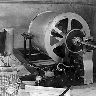
The Wood–Anderson seismometer is a torsion seismometer developed in the United States by Harry O. Wood and John August Anderson in the 1920s to record local earthquakes in southern California. It photographically records the horizontal motion. The seismometer uses a pendulum of 0.8g, its period is 0.8 seconds, its magnification is 2,800 times, and its damping constant is 0.8. Charles Francis Richter developed the Richter magnitude scale using the Wood–Anderson seismometer.
Text is available under the CC BY-SA 4.0 license; additional terms may apply.
Images, videos and audio are available under their respective licenses.