Piazza San Carlo
Piazza San Carlo, previously known as Piazza Reale, Piazza d'Armi, and Place Napoléon, is one of the main city squares in Turin, Italy. It was laid out in the 16th and 17th century and is an example of Baroque style.Photo: Wikimedia, CC BY-SA 4.0.
Notable Places in the Area
Museo Egizio
Museum

Photo: Georgius LXXXIX, Public domain.
The Museo Egizio or Egyptian Museum is an archaeological museum in Turin, Italy, specializing in Egyptian archaeology and anthropology. Museo Egizio is situated 160 metres northeast of Piazza San Carlo.
Equestrian monument of Emmanuel Philibert
Work of art
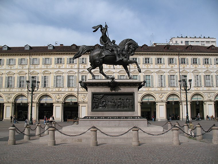 The Equestrian monument of Emmanuel Philibert, commonly known as Caval ëd bronz, rises in the center of Piazza San Carlo in central Turin, in the Piedmont region of Italy.
Santa Cristina, Turin
Church
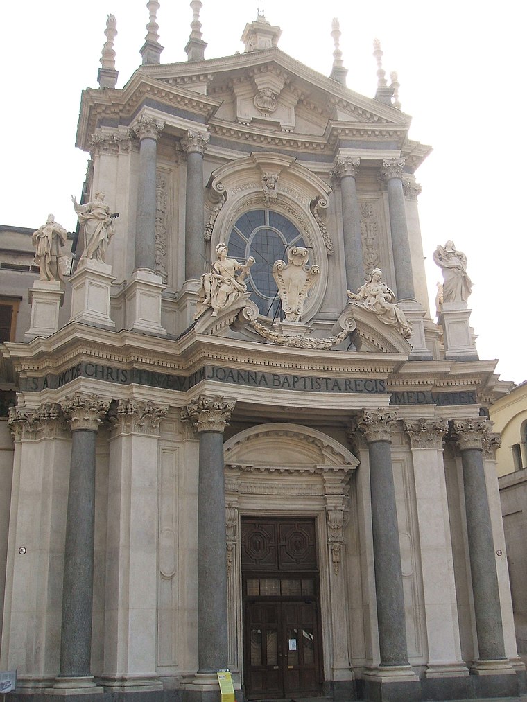
Photo: Georgius LXXXIX, Public domain.
Santa Cristina is a Baroque style, Roman Catholic church located in Turin, region of Piedmont, Italy. Santa Cristina, Turin is situated 100 metres south of Piazza San Carlo.
Localities in the Area


Piazza San Carlo
- Type: Square
- Description: square in Turin, Italy
- Category: locality
- Location: Centro - Crocetta, Turin, Province of Turin, Piedmont, Northwest Italy, Italy, Europe
- View on OpenStreetMap
Latitude
45.06774° or 45° 4' 4" northLongitude
7.68259° or 7° 40' 57" eastElevation
247 metres (810 feet)Named after
Charles BorromeoOpen Location Code
8FQ93M9M+32OpenStreetMap ID
way 22885660OpenStreetMap Feature
place=squareGeoNames ID
6697885Wikidata ID
Q3902294Piazza San Carlo Satellite Map
© OpenStreetMap, Mapbox and Maxar
Also Known As
- Arabic: ساحة سان كارلو
- Chinese: 圣卡洛广场
- Dutch: Piazza San Carlo
- Egyptian Arabic: ميدان سان كارلو
- French: Piazza San Carlo
- German: Piazza San Carlo
- Italian: Piazza San Carlo (Torino)
- Italian: Piazza San Carlo
- Italian: piazza San Carlo
- Japanese: サンカルロ広場
- Slovenian: Piazza San Carlo
- Spanish: Piazza San Carlo
- Spanish: Plaza San Carlo
- Spanish: plaza San Carlo
- Spanish: plaza San Carlos
In the Area
Localities
- Borgo NuovoNeighborhood
- Quadrilatero RomanoNeighborhood
- Complesso Edilizio Aldo MoroQuarter
- San SecondoNeighborhood
- Borgo San SalvarioSuburb
- RossiniNeighborhood
Other Places
Popular Destinations in Piedmont
Escape to a Random Place
Discover the square Plaza de la Encarnación in Seville, Spain and Piazza Eroi Sanremesi in Sanremo, Italy.
About Mapcarta. Thanks to Mapbox for providing amazing maps. Data © OpenStreetMap contributors and available under the Open Database License. Text is available under the CC BY-SA 4.0 license, excluding photos, directions and the map. Description text is based on the Wikipdia page Piazza San Carlo. Photo: Wikimedia, CC BY-SA 4.0.