
West Newton, Massachusetts
42°21′N 71°14′W / 42.350°N 71.233°W

West Newton is one of the thirteen villages within the city of Newton in Middlesex County, Massachusetts, United States.
Among the oldest of the thirteen Newton villages, the West Newton Village Center is a National Register Historic District. The postal ("Zip") code 02465 roughly matches the village limits.
Location[edit]
West Newton is located in the north central part of Newton and is bordered by the town of Waltham on the north and by the villages of Auburndale on the west, Newton Lower Falls on the extreme southwest, Newtonville on the east, and Waban on the south.
Railroad Station[edit]
The West Newton train stop is located near an inn (now small shops) that served as a stagecoach stop. The original station structure was destroyed in the construction of the Massachusetts Turnpike, although the station itself still exists as a stop on the commuter rail.
West Newton Square[edit]
West Newton Square, the town center of West Newton, is home to many local businesses and venues. These include the historic West Newton Cinema, a small theatre that shows independent films, which was originally called the West Newton Theatre.
Many popular restaurants are located in West Newton, ranging from the more upscale Bluebird Cafe to Sweet Tomatoes Pizza, and Paddy’s public house. Blue Ribbon Bar-B-Q is another local favorite, and attracts fans from far and wide.
There are several civic buildings in West Newton Square. They include the Newton Police Department and the local courthouse, both located on Washington Street, as well as the Chinese Community Center on Elm Street. The square once had a branch of the Newton Free Library as well as the Davis Elementary School on Waltham Street. Both closed in the 1980s owing to municipal financial constraints. The library building on Chestnut Street is now a police annex, while the school operates as a community center.
Losses due to turnpike construction[edit]
- West Newton Fire House, Washington Street
- West Newton Boston and Albany Railroad Station
- Lincoln Park, Washington Street, although the Lincoln Park Baptist Church, where Martin Luther King Jr. once preached, still exists.
- The Curve Street neighborhood, originally settled by freed slaves before the Civil War and still inhabited by many black families and the largely black Myrtle Baptist Church, was considerably reduced in size.
- Tony's drug store. Tony moved the business to a corner location out of the way of the turnpike, but to the detriment of the old-fashioned atmosphere. The new place was called the Newtondale Pharmacy.
- The Block: at Washington St. and Davis Court. 1st floor was store fronts; the upper floors were apartments. When you went around to the back you could see all the back porches which overlooked a lot with railroad cars and Border Street.
- Davis Ct: still exists as completely commercial, however, the houses scattered on the land are all gone; 5 Davis Court was a duplex.
Transportation[edit]
West Newton is served by the MBTA Commuter Rail (Framingham/Worcester Line) and is roughly one mile from the Woodland station on the Green Line D branch. West Newton is also served by express buses 505, 553, 554 that provide service to Boston and Waltham.
West Newton also has easy access to the Massachusetts Turnpike and Route 128 (Massachusetts)/I-95. The Massachusetts Turnpike (Interstate 90) runs through West Newton. Routes 30 and 16 also pass through the West Newton.
Places on the National Register of Historic Places[edit]
- Arthur F. Luke House: 221 Prince St. (added March 16, 1990)
- Brae-Burn Historic District: Brae Burn and Windmere Rds. (added March 16, 1990)
- C. A. Sawyer House (Second): 86 Waban Ave. (added March 16, 1990)
- C. G. Howes Dry Cleaning-Carley Real Estate: 1173 Washington St. (added March 16, 1990)
- Charles D. Elliott House: 7 Colman St. (added October 4, 1986)
- Charles W. Noyes House: 271 Chestnut St. (added March 16, 1990)
- Charles Maynard House: 459 Crafts St. (added May 4, 1996)
- Day Estate Historic District: Commonwealth Ave. and Dartmouth St. (added March 16, 1990)
- Dr. Samuel Warren House: 432 Cherry St. (added February 3, 1985)
- First Unitarian Society in Newton: 1326 Washington St. (added October 4, 1986)
- Galen Merriam House: 102 Highland St. (added October 4, 1986)
- George W. Eddy House: 85 Bigelow Rd. (added March 16, 1990)
- House at 170 Otis Street: 170 Otis St. (added October 4, 1986)
- Levi Warren Jr. High School: 1600 Washington St. (added March 16, 1990)
- Nathaniel Topliff Allen Homestead: 25 Webster St. (added February 9, 1978)
- Peirce School: 88 Chestnut St. (added 1979)
- Railroad Hotel: 1273-1279 Washington St. (added October 4, 1986)
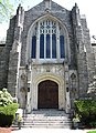
- Second Church in Newton: 60 Highland St. (added March 16, 1990)
- Webster Park Historic District: Along Webster Pk. and Webster St. between Westwood St. and Oak Ave. (added October 4, 1986)
- West Newton Hill Historic District: Roughly bounded by Highland Ave., Lenox, Hampshire, and Chestnut Sts. (added October 4, 1986)
- West Newton Village Center Historic District: Roughly Washington St. from Putnam to Davis Ct. (added March 16, 1990)
- West Parish Burying Ground: River and Cherry Sts. (added December 13, 2004)
- Windsor Road Historic District: Windsor and Kent Rds. (added March 16, 1990)
Fourteen of these are pictured below.
-
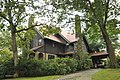 Arthur F Luke House
 -
 C G Howes Dry Cleaning - Carley Real Estate
 -
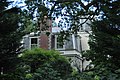
 Charles D Elliott House
 -
 Charles Maynard House
 -
 Dr Samuel Warren House
 -
 Galen Merriam House
 -
 170 Otis Street
 -
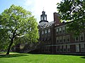 Levi F Warren Jr High School
 -
 Nathaniel Topliff Allen Homestead
 -
 George W Eddy House
 -
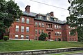 Peirce School
 -
 Railroad Hotel
 -
 Second Church
 -
 West Parish Burying Ground


Notable people[edit]
- Mitch Albom, author
- Isaac Asimov, science fiction author of I, Robot
- Sheldon Brown, bicycle mechanic and technical authority
- Richard B. Carter native and lifelong resident of West Newton, head of Carter's Ink Company from 1905 to 1949, lived at 11 Forest Ave. WN
- Matt Damon, actor, first made famous from Good Will Hunting
- Bette Davis, actress
- Joe DeNucci
- Ralph Waldo Emerson, essayist, lecturer and author
- Mickey Fisher (1904/05–1963), basketball coach
- Nathaniel Hawthorne, Sophia Peabody Hawthorne, Julian Hawthorne, and Rose Hawthorne
- Steven Hyman, neuroscientist and Provost of Harvard University
- Julian Jaynes, psychologist, professor, writer
- John Krasinski
- Timothy Leary, Harvard professor and LSD researcher
- Matt LeBlanc, actor most widely known as Joey in Friends
- Jack Lemmon, actor
- Mark Mahoney, tattoo artist, owner of Shamrock Social Club in Los Angeles, whose celebrity clients include Johnny Depp, Angelina Jolie
- David Mamet, playwright, screenwriter and film director
- Mark Mancuso, meteorologist The Weather Channel (United States)
- Horace Mann
- Olga C. Nardone, Wizard Of Oz Munchkin "1939" (Villager, SleepyHead, Middle Lullaby League) 6/8/1921—9/24/2010 10 Bellevue Street
- Don Nottebart, MLB player
- Cyrus Peirce, for whom Peirce School is named
- Osgood Perkins, actor, father of Anthony Perkins
- Rebecca Pidgeon, film actress who is married to David Mamet
- Seth Putnam, leader from noisecore band Anal Cunt
- Morrie Schwartz, subject of the best-selling book Tuesdays With Morrie
- Harriet Beecher Stowe, author of Uncle Tom's Cabin
- Edward Wagenknecht, American literary critic, prolific writer and BU professor lived on Otis Street, WN
- Frank E. Winsor, for whom Winsor Dam is named, lived at 189 Mt. Vernon St. WN
- Howard Zinn
External links[edit]
- History of Newton Villages
- Historic postcard of Brae Burn Country Club WN
- Historic postcard of West Newton Railway Station which was destroyed when the Turnpike came through
Municipalities and communities of Middlesex County, Massachusetts, United States | ||
|---|---|---|
| Cities |  | |
| Towns |
| |
| CDPs | ||
| Other villages |
| |
| Footnotes | ‡This populated place also has portions in an adjacent county or counties | |
| International | |
|---|---|
| National | |