Quake Info: Light Mag. 4.2 Earthquake - Inland Sea of Japan, 29 km Northeast of Matsuyama, Ehime, Japan, on Thursday, Jul 8, 2021 at 2:39 am (GMT +9) - 4 User Experience Reports
Contact | RSS | EN | DE | EL | ES | FR | IT | RU

Light mag. 4.2 earthquake - Inland Sea of Japan, 29 km northeast of Matsuyama, Ehime, Japan, on Thursday, Jul 8, 2021 at 2:39 am (GMT +9)

Light mag. 4.2 earthquake - Inland Sea of Japan, 29 km northeast of Matsuyama, Ehime, Japan, on Thursday, Jul 8, 2021 at 2:39 am (GMT +9) Light mag. 4.2 earthquake - Inland Sea of Japan, 29 km northeast of Matsuyama, Ehime, Japan, on Thursday, Jul 8, 2021 at 2:39 am (GMT +9)

Light magnitude 4.2 earthquake at 43 km depth

7 Jul 17:43 UTC: First to report: VolcanoDiscovery after 4 minutes.
7 Jul 17:45: Now using data updates from NIED
Update Wed, 7 Jul 2021, 17:54

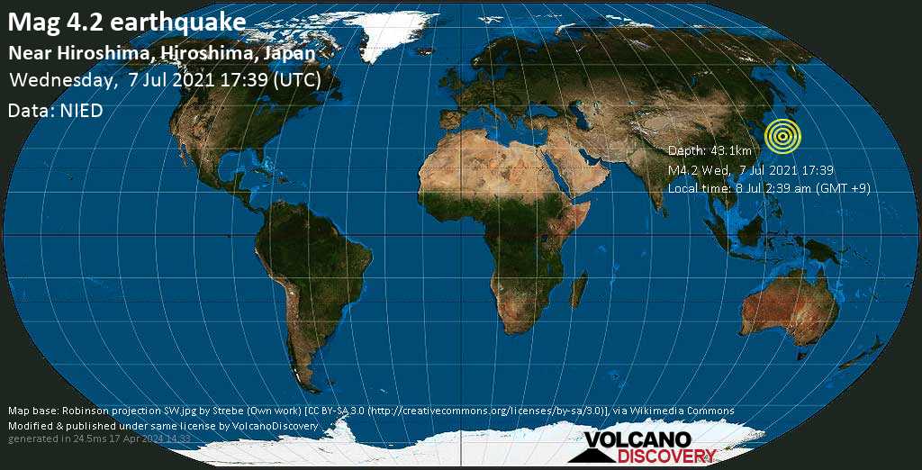
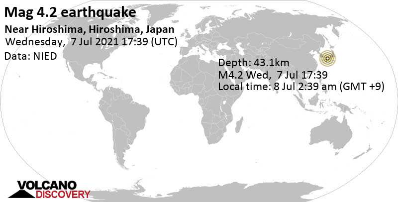
Moderate magnitude 4.2 earthquake 29 km northeast of Matsuyama, Japan

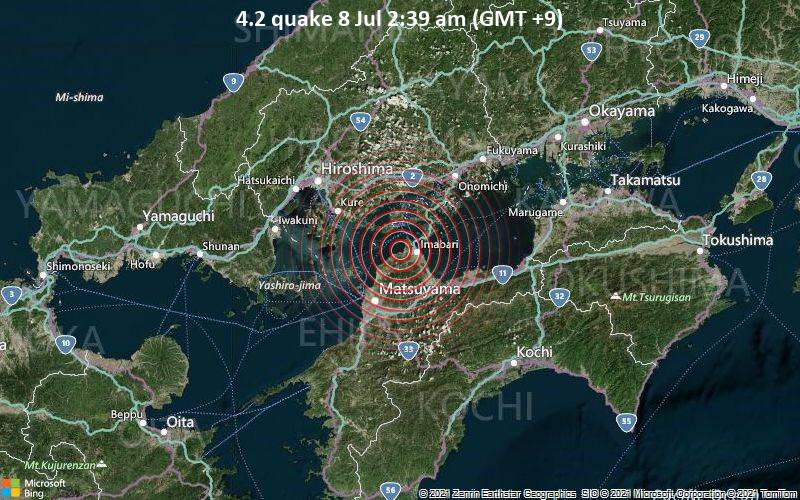
4.2 quake 8 Jul 2:39 am (GMT +9)
A magnitude 4.2 earthquake near Matsuyama, Matsuyama-shi, Ehime, Japan, was reported only 15 minutes ago by Japan's National Research Institute for Earth Science and Disaster Resilience (NIED), considered the main national agency that monitors seismic activity in this part of the world. The earthquake occurred at a moderately shallow depth of 43.1 km beneath the epicenter early morning on Thursday 8 July 2021 at 2:39 am local time. The exact magnitude, epicenter, and depth of the quake might be revised within the next few hours or minutes as seismologists review data and refine their calculations, or as other agencies issue their report.
A second report was later issued by the European-Mediterranean Seismological Centre (EMSC), which listed it as a magnitude 4.0 earthquake.
Towns or cities near the epicenter where the quake might have been felt as very weak shaking include Hōjō (pop. 28,000) located 16 km from the epicenter, Matsuyama (pop. 443,300) 29 km away, Takehara (pop. 30,500) 29 km away, Saijō (pop. 58,800) 31 km away, Kure (pop. 196,600) 35 km away, Niihama (pop. 123,100) 39 km away, Mihara (pop. 80,400) 40 km away, and Onomichi (pop. 90,900) 47 km away.

Download the Volcanoes & Earthquakes app and get one of the fastest seismic alerts online: Android | iOS

Earthquake details

Date & timeJul 7, 2021 17:39:06 UTC
Local time at epicenterThursday, Jul 8, 2021 at 2:39 am (GMT +9)
StatusConfirmed
Magnitude4.2
Depth43.1 km
Epicenter latitude / longitude34.076°N / 132.902°E (Inland Sea of Japan, Japan)
Antipode34.076°S / 47.098°W
Shaking intensityLight shaking
Felt4 reports
Primary data sourceNIED (National Research Institute for Earth Science and Disaster Resilience)
Nearest volcanoSanbe (120 km / 75 mi)
Nearby towns and cities16 km (10 mi) NE of Hōjō (Matsuyama) (pop: 28,000) | Show on map | Quakes nearby
29 km (18 mi) NNE of Matsuyama (pop: 443,300) | Show on map | Quakes nearby
29 km (18 mi) S of Takehara (pop: 30,500) | Show on map | Quakes nearby
31 km (20 mi) NW of Saijo (pop: 58,800) | Show on map | Quakes nearby
35 km (22 mi) ESE of Kure (pop: 196,600) | Show on map | Quakes nearby
39 km (24 mi) WNW of Niihama (pop: 123,100) | Show on map | Quakes nearby
40 km (25 mi) SSW of Mihara (pop: 80,400) | Show on map | Quakes nearby
47 km (29 mi) SW of Onomichi (pop: 90,900) | Show on map | Quakes nearby
55 km (34 mi) SE of Hiroshima (pop: 1,143,800) | Show on map | Quakes nearby
645 km (401 mi) WSW of Tokyo (pop: 8,336,600) | Show on map | Quakes nearby
45 km (28 mi) E of Hashira Island (pop: 184) | Show on map | Quakes nearby
66 km (41 mi) WNW of Shikoku Island (pop: 4,142,000) | Show on map | Quakes nearby
Weather at epicenter at time of quakeLight Rain 27°C (81 F), humidity: 91%, wind: 3 m/s (6 kts) from SW
Estimated seismic energy released1.3 x 1011 joules (35 megawatt hours, equivalent to 30.1 tons of TNT) | about seismic energy
Show interactive Map
[smaller] [bigger]

Data for the same earthquake reported by different agencies

Info: The more agencies report about the same quake and post similar data, the more confidence you can have in the data. It takes normally up to a few hours until earthquake parameters are calculated with near-optimum precision.
Mag.DepthLocationSource
4.243 kmNear Hiroshima, Hiroshima, JapanNIED
4.040 kmWESTERN HONSHU, JAPANEMSC

Seismograms

Seismic station: Kochi Monobe (JMN/JP network) | Distance from quake: 98 km / 61 mi | Show on map | Station Info
Seismic station Kochi Monobe: vertical movement plot around time of quake (source: IRIS/BUD)
Seismogram (vertical component) around time of quake. Thin dotted red line indicates time of quake. Seismic waves arrive some time later, depending on distance. Bandpass filter applied: 0.2-10.0 Hz. Source: IRIS Buffer of Uniform Data (BUD) webtool
Show more

User reports for this quake (4)

User reports estimate the perceived ground shaking intensity according to the MMI (Modified Mercalli Intensity) scale.
Contribute:
Leave a comment if you find a particular report interesting or want to add to it.
Flag as inappropriate.
Mark as helpful or interesting.
Send your own user report!
Translate
Iwakuni / Light shaking (MMI IV) / horizontal (sideways) swinging / 5-10 s : Had woken up randomly a few minutes before and as I was trying to fall back asleep it happened | One user found this interesting.  
Hiroshima (56.9 km NW of epicenter) [Map] / Light shaking (MMI IV) / complex motion difficult to describe / 1-2 s
Yamaguchi (62.7 km W of epicenter) [Map] / Moderate shaking (MMI V) / vibration and rolling / 2-5 s : Scared  
Iwakuni / Weak shaking (MMI III) / rattling, vibrating / 2-5 s

Earlier earthquakes in the same area

Try our free app!
Volcanoes & Earthquakes - new app for Android
Android | iOS version

Support us - Help us upgrade our services!

We truly love working to bring you the latest volcano and earthquake data from around the world. Maintaining our website and our free apps does require, however, considerable time and resources.
We need financing to increase hard- and software capacity as well as support our editor team. We're aiming to achieve uninterrupted service wherever an earthquake or volcano eruption unfolds, and your donations can make it happen! Every donation will be highly appreciated. If you find the information useful and would like to support our team in integrating further features, write great content, and in upgrading our soft- and hardware, please make a donation (PayPal or Online credit card payment).

Planned features:
  • Improved multilanguage support
  • Tsunami alerts
  • Faster responsiveness
Thanks to your past donations, these features have been added recently:
  • Design upgrade
  • Detailed quake stats
  • Additional seismic data sources
Download and Upgrade the Volcanoes & Earthquakes app to get one of the fastest seismic and volcano alerts online:
Android | IOS
Thank you!
Sources: VolcanoDiscovery / VolcanoAdventures and other sources as noted.
Use of material: Most text and images on our websites are owned by us. Re-use is generally not permitted without authorization. Contact us for licensing rights.
Volcanoes & Earthquakes
VolcanoDiscovery Home
Volcanoes | Earthquakes | Photos | Volcano News | App
Adventure & Study Travel
Tours to Volcanoes and Volcanic Areas: walking tours, photo tours, study tours
Tours & Dates | FAQ | About us
Get our newsletter!
Company info
Contact | Legal info | Terms & conditions
Follow us
Follow us on facebook Follow us on Instagram Follow us on Twitter Visit our Youtube channel
EN | DE | EL | ES | FR | IT | RU
VolcanoDiscovery GmbH, Germany, Reg. nr.: HRB 103744, EU Tax Id: DE 310 395 322 owned and created by
Dr. Tom Pfeiffer, volcanologist, volcano photographer, tour organizer member of
IAVCEI
Volcanological Society
Ecotourism Greece
Insured by R+V
VolcanoDiscovery © 2004- All Rights Reserved | Privacy - cookie settings