A continuación aparece una instantánea de la página web tal y como aparecía en 15/04/2024 (la última vez que nuestro rastreador la visitó). Esta es la versión de la página que se usó para la clasificación de los resultados de búsqueda. Puede que la página haya cambiado desde la última vez que la guardamos en caché. Para ver lo que puede haber cambiado (sin la información destacada), ve a la página actual.
Bing no se hace responsable del contenido de esta página.
List of highest mountains - Simple English Wikipedia, the free encyclopediaJump to content
From Simple English Wikipedia, the free encyclopedia
ɫṲ
Aerial view of Mount Everest from the south. The peak rises over Lhotse, while Nuptse is the ridge on the left.
This is a list of the highest mountains in the world. There are at least 109 mountains on Earth that are higher than 7,200 metres (23,622 ft) above sea level. Most of these are in central or southern Asia. It is hard to measure how tall a mountain is, so these measurements may not be exact. It is also hard to figure out if two peaks close to each other are part of the same mountain or are two different mountains.
↑For Nepal, the heights indicated on the Nepal Topographic Maps are followed. For China and the Baltoro Karakoram, the heights are those of "The Maps of Snow Mountains in China". For the Hispar Karakoram the heights on a Russian 1:100,000 topo map [1]Archived 2008-04-27 at the Wayback Machine seem to be more accurate than the customarily quoted heights probably based on US army maps from the 50s [2]Archived 2013-07-25 at the Wayback Machine. Elsewhere, unless otherwise indicated, heights are those in Jill Neate's "High Asia".
↑The region is beautifully covered by Terraserver.com and Google Maps Satellite imagery. Coordinates were established by comparing topographical maps with these satellite images.
↑The prominence data were extracted from a combination of maps and computer aided analysis of NASA's 3" SRTM data. Prominences over 1,450 m were copied from this website.
↑Here defined as the first higher mountain beyond the key saddle with at least 500 m prominence itself.
↑The number of ascents and failed attempts up to 2004 is extracted from the Alpine Club Himalayan index. These are the number of expeditions (not individuals) that announced their ascent or attempt in a journal. They are probably quite accurate for the rarely climbed peaks (though omissions were noted), but greatly underestimate the number of ascending parties on the easier and/or more popular mountains, like most eight-thousanders. For instance, Mt Everest has been scaled 2,251 times by individuals up to 2004 [3].
↑Given the large differences between multiple "final" measurements of Mt Everest, the traditional 8,848 m is listed. For more information, see Mount Everest#Measurement.
↑Everest IS parent to K2 by the definition of topographic prominence. See also, the discussion page.


 1. The summit of Mount Everest, the highest point on Earth
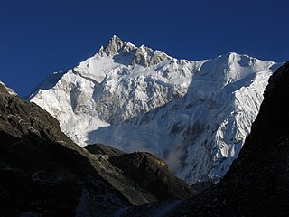 3. Kangchenjunga, the second-highest mountain of the Himalaya

 7. Dhaulagiri in the Himalaya
 9. Nanga Parbat in the Himalaya
 10. Annapurna I in the Himalaya
 11. Gasherbrum I, the second-highest mountain of the Karakoram
 12. Broad Peak, the third-highest mountain of the Karakoram
 13. Gasherbrum II in the Karakoram
 14. Shishapangma in the Himalaya


