Kraków Old Town
Old town of Kraków, Poland / From Wikipedia, the free encyclopedia
Dear Wikiwand AI, let's keep it short by simply answering these key questions:
Can you list the top facts and stats about Kraków Old Town?
Summarize this article for a 10 year old
Kraków Old Town is the historic central district of Kraków, Poland.[1] It is one of the most famous old districts in Poland today and was the centre of Poland's political life from 1038 until King Sigismund III Vasa relocated his court to Warsaw in 1596.
| UNESCO World Heritage Site | |
|---|---|
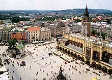
 Market Square | |
| Location | Kraków, Kraków County, Lesser Poland Voivodeship, Poland |
| Criteria | Cultural: (iv) |
| Reference | 29bis |
| Inscription | 1978 (2nd Session) |
| Extensions | 2010 |
| Area | 149.65 ha (369.8 acres) |
| Buffer zone | 907.35 ha (2,242.1 acres) |
| Coordinates | 50°3′41″N 19°56′14″E |


The entire medieval old town is among the first sites chosen for the UNESCO's original World Heritage List, inscribed as Cracow's Historic Centre.[2][3] The old town is also one of Poland's official national Historic Monuments (Pomnik historii) chosen in the first round, as designated 16 September 1994, and tracked by the National Heritage Board of Poland.
The Old Town is known in Polish as Stare Miasto. It is part of the city's first administrative district which is also named "Stare Miasto", although it covers a wider area than the Old Town itself.
Medieval Kraków was surrounded by a 3 km (1.9 mi) defensive wall complete with 46 towers and seven main entrances leading through them. The fortifications around the Old Town were erected over the course of two centuries.[4] The current architectural plan of Stare Miasto – the 13th-century merchants' town – was drawn up in 1257 after the destruction of the city during the Tatar invasions of 1241 followed by raids of 1259 and repelled in 1287.[4] The district features the centrally located Rynek Główny, or Main Square, the largest medieval town square of any European city.[5] There is a number of historic landmarks in its vicinity, such as St. Mary's Basilica (Kościół Mariacki), Church of St. Wojciech (St. Adalbert's), Church of St. Barbara, as well as other national treasures. At the centre of the plaza, surrounded by kamienice (row houses) and noble residences, stands the Renaissance cloth hall Sukiennice (currently housing gift shops, restaurants and merchant stalls) with the National Gallery of Art upstairs. It is flanked by the Town Hall Tower (Wieża ratuszowa).
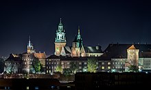
The whole district is bisected by the Royal Road, the coronation route traversed by the Kings of Poland. The Route begins at St. Florian's Church outside the northern flank of the old city walls in the medieval suburb of Kleparz; passes the Barbican of Kraków (Barbakan) built in 1499, and enters Stare Miasto through the Florian Gate. It leads down Floriańska Street through the Main Square, and up Grodzka to Wawel, the former seat of Polish royalty overlooking the Vistula river.
In the 19th century most of the Old Town fortifications were demolished.[4] The moat encircling the walls was filled in and turned into a green belt known as Planty Park.
Oops something went wrong:


