
Talk:Arabian Sea
| This It is of interest to the following WikiProjects: |
|||||||||||||||||||||||||||||||||||||||||||||||||||||||||||||
| |||||||||||||||||||||||||||||||||||||||||||||||||||||||||||||


Largest[edit]
is the arabian sea the largest in the world? hoorah —Preceding unsigned comment added by 65.175.134.16 (talk • contribs) 16:05, 8 February 2005
Persian Sea[edit]
every gulf has been named after its sea, persian gulf was named after persian sea or pars sea , the correct name is PERSIAN SEA , as persians call it daryayeh Pars wiki is wrong some one fix this missleading information —Preceding unsigned comment added by 24.87.73.251 (talk • contribs) 21:57, 15 July 2007
"Part coastal Persia"?[edit]
I've changed the above phrase to Iran. The link to Persia didn't seem to be consistent with using modern or present-day names of present-day geographic locations. 4.243.206.153 07:31, 1 April 2007 (UTC)
Queen of the Arabian City reference to Kochi in India
This is ridiculous! the source cited by the author of this reference is an Indian newspaper. Just because one country where the Arabian sea reaches (India) feel that one of their ports is teh "Queen" doesn't make it so. Kochi as the Queen of Arabian sea is vitually unheard of in any of the other countries where the Arabian sea reaches. This reference must be removed....I tried to but the page seems inaccessible due to some maintenance being performed or something...someone please do this virtuous deed and remove this ridiculous reference —Preceding unsigned comment added by 74.98.143.43 (talk • contribs) 21:08, 7 April 2007
Indian Sea[edit]
This sea should be named Indian Sea since India has the most coast line not Arabian countries. — Preceding unsigned comment added by 2601:2C6:4403:42AD:99A2:E9B5:1949:BE34 (talk) 00:48, 30 August 2015 (UTC)
Arabic name[edit]
Currently Bahr al-'Arab and Bahr al-'arab redirect here, and the first sentence says that this is the Arabic name for the Arabian Sea. But there is also a river in Sudan named Bahr al-Arab which sources say is also spelled "Bahr al-'Arab". For example, see: Bahr al-'Arab and Bahr al-Ghazal at Encyclopædia Britannica Online, As Sudd and Baḩr al Ghazāl at MSN Encarta.
From what little I know of Arabic, "Bahr" (or "Baḩr" more properly) can mean river, lake, or sea. So I wonder if something should be done about this. I realize the Arabian Sea is far more notable than a minor stream in Sudan. On the other hand the stream drains the Darfur region, so it may be of interest these days. Perhaps one of those "for the river in Sudan see..." blurbs? Pfly (talk) 07:13, 23 January 2008 (UTC)
- This is a fine mess. There is going to have to be some disambiguating hing a dinga shimga done. And the article about the river is unsourced. I would tell you to go ahead and add the dab templates, but I'm thinking that Bahr al-Arab should be moved to Bahr al-'Arab or Bahr al-'arab (or even Baḩr al-A/arab). The first two options would require deleting the existing redirects, and you can't do that unless you are an admin (I can do it). I do want to be able to point to reliable sources for the form of the name. Any thoughts? -- Donald Albury 11:53, 23 January 2008 (UTC)
- Heh.. I was planning to add a little to the river article and give a few references.. when I manage to get around to it. I was thinking of maybe adding one of those "for the river..." templates to the top of the Arabian Sea page. I forgot how, but I think I've done it before and it wasn't hard. As for redirects, I thought you could edit the link redirected to without being an admin. And I think you can move pages without being an admin, at least after something like five days of using an account. But not knowing much (anything) about Arabic, it's hard for me to have much of an idea about your naming comments. The NGA geonames source I mentioned seemed to use the same names and spellings (including variants!) for both the sea and the river, if I recall right. Maybe I'll ask for the Arabic on the language ref desk. Maybe transcription of Arabic into the Latin alphabet is too messy for a simple answer. In any case, I could add one of the little disamig blurb templates to this page, but am probably not up for the work of making a full-blown disambig page and fixing all the relevant links etc. Disambig work can be so tedious.. Anyway, I was pleased to see your reply this morning -- somehow I thought this was too esoteric a topic. I have no time today, but wanted to reply before heading out. Later. Pfly (talk) 17:05, 23 January 2008 (UTC)
- If you want to move an article to a name that is currently occupied by a redirect, you have to delete the redirect first. Maybe the easiest thing is to convert the redirects at Bahr al-'Arab and Bahr al-'arab to dabs, i.e.,
- Bahr al-'Arab can refer to:
- [[Bahr al-Arab]], a river in Darfur
- the [[Arabian Sea]]
- Bahr al-'Arab can refer to:
- -- Donald Albury 21:12, 23 January 2008 (UTC)
- If you want to move an article to a name that is currently occupied by a redirect, you have to delete the redirect first. Maybe the easiest thing is to convert the redirects at Bahr al-'Arab and Bahr al-'arab to dabs, i.e.,
- Heh.. I was planning to add a little to the river article and give a few references.. when I manage to get around to it. I was thinking of maybe adding one of those "for the river..." templates to the top of the Arabian Sea page. I forgot how, but I think I've done it before and it wasn't hard. As for redirects, I thought you could edit the link redirected to without being an admin. And I think you can move pages without being an admin, at least after something like five days of using an account. But not knowing much (anything) about Arabic, it's hard for me to have much of an idea about your naming comments. The NGA geonames source I mentioned seemed to use the same names and spellings (including variants!) for both the sea and the river, if I recall right. Maybe I'll ask for the Arabic on the language ref desk. Maybe transcription of Arabic into the Latin alphabet is too messy for a simple answer. In any case, I could add one of the little disamig blurb templates to this page, but am probably not up for the work of making a full-blown disambig page and fixing all the relevant links etc. Disambig work can be so tedious.. Anyway, I was pleased to see your reply this morning -- somehow I thought this was too esoteric a topic. I have no time today, but wanted to reply before heading out. Later. Pfly (talk) 17:05, 23 January 2008 (UTC)
Ah I read too quickly and misunderstood. Or maybe I assumed one could cut and paste between an article and a redirect, though I guess that make link fixing a pain. In any case, your redirect->dabs idea makes sense. For now I just added a "hatnote" to the two articles. It might be non-ideal, but it was quick and I have to go to bed... Pfly (talk) 08:24, 24 January 2008 (UTC)
- Moving articles by cut and paste is a bad idea, as it loses the edit history, which the GFDL requires be preserved. The 'hatnotes' sound fine. Now that I think about it, a disambig page would be overkill. -- Donald Albury 15:01, 24 January 2008 (UTC)
Parsyan sea[edit]
due to the fact that Indian, Iranian and Pakistani population who live in the coastal areas of this sea is more than its arab population , the name of the sea must change back to PARSYAN SEA or INDIAN sea like it was before. even Indians ,Iranians ,Pakistanis ,Indonisians and Baluchis consist of 53% of those new arab state population . —Preceding unsigned comment added by 76.166.197.66 (talk) 22:59, 7 May 2010 (UTC)
As an Iranian Persian, I feel sorry for you. Historically, Arabian sea is tied to the Arab culture which moved slaves, spices and other things along the routes in this sea (Specially Yemenis were active in the trades.) As the language of the traders there was mostly Arabic (As Iranian's mostly traded by land), the Sea must be in fact called "The Arabian Sea". This has nothing to do with the legitimacy of the name for Persian Gulf though. —Preceding unsigned comment added by 213.233.169.184 (talk) 12:06, 23 May 2010 (UTC)
- What it should be called is irrelevant. This article must reflect what it is called. Bazonka (talk) 12:33, 23 May 2010 (UTC)
Actual size[edit]
According to many sources its size is 1,498,320 sq km instead. Which is correct? 116.49.135.38 (talk) 15:39, 21 July 2010 (UTC)
Bin Laden[edit]
Should it be included that this is the final resting place for Osama bin Laden? Adwiii Talk 21:41, 3 May 2011 (UTC)
File:Map of persia.jpg Nominated for Deletion[edit]

|
An image used in this article, File:Map of persia.jpg, has been nominated for deletion at Wikimedia Commons in the following category: Deletion requests December 2011
Don't panic; a discussion will now take place over on Commons about whether to remove the file. This gives you an opportunity to contest the deletion, although please review Commons guidelines before doing so.
To take part in any discussion, or to review a more detailed deletion rationale please visit the relevant image page (File:Map of persia.jpg) This is Bot placed notification, another user has nominated/tagged the image --CommonsNotificationBot (talk) 11:16, 12 February 2012 (UTC) |
- that is a very good useful map and had been published in Iranian public website and web loges and have no copy right. in Iran copy right is not applicable to the none private picture.
Adding Indian ports in the list of Major Ports[edit]
Hi Everyone , Can we add the following Indian deep water ports under the major ports section
- Kandla Port - 81.88 MTU
- Nava Sheva - 64.29 MTU
- Mumbai Port - 54.58 MTU
- Mormugoa - 50.02 MTU
- Cochin - 17.87 MTU
The above information is sourced from annual numbers from Shipping ministry of India - 2011 as well as American Association of Port Authorities ranking of ports - 2009
Wikikapil (talk) 05:02, 13 March 2012 (UTC)
File:Old map.JPG Nominated for Deletion[edit]
|
|
An image used in this article, File:Old map.JPG, has been nominated for deletion at Wikimedia Commons in the following category: Deletion requests February 2012
Don't panic; a discussion will now take place over on Commons about whether to remove the file. This gives you an opportunity to contest the deletion, although please review Commons guidelines before doing so.
To take part in any discussion, or to review a more detailed deletion rationale please visit the relevant image page (File:Old map.JPG) This is Bot placed notification, another user has nominated/tagged the image --CommonsNotificationBot (talk) 19:32, 26 March 2012 (UTC) |
- The-Periplus-of-the-Erythraean-Sea. part 34- 35 -Persian gulf- Persian sea
.[9] [10] — Preceding unsigned comment added by Maahmaah (talk • contribs) 09:56, 3 April 2012 (UTC) that is a very good useful map and had been published in Iranian public website and web loges and have no copy right. in Iran copy right is not applicable to the none private picture. — Preceding unsigned comment added by Basp1 (talk • contribs) 07:26, 7 April 2012 (UTC)
- that is a very good useful map and had been published in Iranian public website and web loges and have no copy right. in Iran copy right is not applicable to the none private picture. — Preceding unsigned comment added by Basp1 (talk • contribs) 07:33, 7 April 2012 (UTC)
Alternative names[edit]
The Arabian Sea historically and geographically had many other different names by Muslim travelers and European geographers such as: Akhzar Sea, Persian Sea,[1], Chah Bahar,[2] Makran Sea,[3] Sindhu Sagar,[4] Erythraean Sea,[5] Dera Macran,[6] and Sindh Sea.[7] The name of the sea is disputed amongst some historians in Iran and Pakistan.[8] They collectively argue and believe that the name Arabian Sea was first used on maps due to colonialism in the past 400 years.[9] Among historians, travellers and geographers of the Islamic era, many of them writing in Arabic or persian from the 9th to the 17th century, Ibn Khordadbeh,[10] Ibn al-Faqih,[11] Ibn Rustah,[12] Sohrab,[13] Ramhormozi,[14] Abu Ishaq Ibrahim ibn Muhammad al-Farisi al Istakhri,[15] Abu al-Hasan Ali ibn al-Husayn ibn Ali al-Mas'udi,[16] Al-Mutahhar ibn Tahir al-Maqdisi (d. 966),[17] Ibn Hawqal,[18] Al-Muqaddasi,[19] Ibn Khaldun, Mohammad ibn Najub Bekiran,[20] Abu Rayhan Biruni,[21] Muhammad al-Idrisi,[22] Yaqut al-Hamawi,[23] Zakariya al-Qazwini,[24] Abu'l-Fida,[25] Al-Dimashqi,[26] Hamdollah Mostowfi,[27] Al-Nuwayri,[26] Ibn Batutta,[28] Katip Çelebi and other sources have used the terms, "Bahr-i Mohit", "Bahr-i Mohit i Ajam", "Bahr-al-'Ajami", "Bahr-i-Fars", "Dera-i-Fars"(Persian), and "Bahr-i Mokran/Mecran", "Bahr-i Al Akhzar" (green) to refer to the current Arabian sea. ("Bahr-in Arabic means Sea" and Mohit means ocean) none of them referred to as Arabian sea.[29] — Preceding unsigned comment added by Maahmaah (talk • contribs) 12:25, 14 April 2012
References
- ^ [1],(par34-35)
- ^ [2]
- ^ [3]
- ^ Geographica Indica - The Arabian Sea
- ^ [4]
- ^ 1794, Orbis Veteribus Notus by Jean Baptiste Bourguignon d'Anville
- ^ National Atlas of India Abridged Edition Edited by Dr. P.Nag. Lakshadweep sea(Arabian sea). National atlas and thematic mapping organization department of science & technology government of India 2002]
- ^ [5]
- ^ [6]
- ^ "Al-Massalek wa al-Mamalek", Leiden edition, 1889. p. 233
- ^ The abrdiged "Al-Buldan", Leiden, 1885, p. 8
- ^ Ibn Rustah, Kitāb al-A'lāk an-Nafīsa, ed. M. J. De Goeje, Bibliotheca Geographorum Arabicorum [BGA], Leiden, E. J. Brill, 1891/1892. p. 81
- ^ Ajayeb al-Aqalim al-Saba ila Nehayate al-Mara, (Vienne: 1929), p. 59. 9th century AD.
- ^ Nakhoda Bozorg ibn Shahriyar Ramhormozi was another Persian geographer of the classical Islamic era, "Ajayeb al-Hind", ed: M. Davis, Leiden 1886, p. 41
- ^ "Massalek al-Mamalek", ed.: De M.J. Goeje, Leiden 1927, p. 28
- ^ "Muruj adh-dhahab wa ma'adin al-jawhar (The Meadows of Gold and Mines of Gems)", English Translation by Aloys Sprenger, Vol I, (London: 1841), p. 259
- ^ al-Bad’ wa-l Tarikh, (Paris: 1907) Tom IV, p. 58.
- ^ "The Oriental Geography of Ebn Hawkal", Translated by Sir Williams Ouseley (London: 1800) p. 62; "Surat al-Arḍ"(Leiden 1938), Vol I, p. 42.
- ^ Ahsan al-Taqasim fi Ma’rifat al-Aqalim. Ed: De A.J. Goeje, (Leiden 1906), p. 17.
- ^ "Jahan Nama", Vol I. p. 44. .
- ^ "Al-Tafhim le-awa’el Sena al-Tanjim" ed.: Jalal al-Din Homai (Tehran: 1318 Hijri Sola Calendar), p. 167. Also in "Qanun Masudi"(Heydarabad, 1955), Vol. II. p. 558.
- ^ "Geographic d’Edirisi" traduite de l’Arabe en Francais par P. Amedee Jaulert (Recueil des voyages et des memoires publiees par la Societe de Geographie), (Paris: 1840), Vols. VI and VI. "Nuzhat al-Mushtaq fi Ikhtraq al-Afar", (Rome : 1878). p. 9
- ^ "mu’jam al-Buldan",(Cairo: 1906), Vol. 2, p. 68.
- ^ "Athar al-Bilad" (Gutingen: 1848), p. 104.
- ^ "Taqwim al-Buldan", Geographie d’Aboulfeda traduite de l’Arab par M. Reinaud, 2 Vols. (Paris: 1848), Vol 1, p. 23.
- ^ a b Quoted also in Mohammad Javad Mashkoor in an article titled "Nam-i Khalij Fars" in the proceeding of the "Seminar on Khalij-e-Fars" (Tehran: 1964). p. 46.
- ^ "Nuzhat al-Qolub", ed: Mohammad Dabir Sayaqi, (Tehran: 1336 Hijri Solar Year), p. 164.
- ^ "The Travels of Ibn Babutta", translated from the abrdiged Arabic MMS of Cambridge by the Rev. Samuel Lee(Cambridgde: 1824), p. 56
- ^ [7]
05:26, 19 December 2019 (UTC) — Preceding unsigned comment added by Basp1 (talk • contribs)
- Basp1 you can work at your sandbox. Currently all you have been adding is content sourced to Wikipedia and a persian blog. Read WP:RS, WP:SPS, WP:SNYTH and WP:FRINGE.--SharabSalam (talk) 06:00, 19 December 2019 (UTC
- the books that have been mentioned are very important and reliable source in the world. you seem to be against any reliable source that mentioned the facts. you think that this sources Are not reliable and you are reliable ?? you should prove it :Yaqut al-Hamawi mentioned it as Akhzar sea [11] Ibn Khordadbeh ,
Ibn Sa'id al-Maghribi , Muhammad al-Idrisi,Istakhri ,Mahmud al-Kashgari ,Khashkhash Ibn Saeed Ibn Aswad and Muhammad ibn Musa al-Khwarizmi had mentioned the sea as Persian sea and sea of Mokran.there are many maps and atlases which prove the names other than Arabian sea in the past centuries .there are a lot of famous facts and documents.
some of the midival map including the map by Vincenzo Maria Coronelli, 1693 had mentioned the Persian sea and also Makran. thumb|The western part of the Indian Ocean, by Vincenzo Maria Coronelli, 1693 from his system of global gores the Makran coast
- thumb|Basra bahrefars — Preceding unsigned comment added by Basp1 (talk • contribs) 06:50, 19 December 2019 (UTC)
[[13]] i will bring for you many maps and documents please wait — Preceding unsigned comment added by Basp1 (talk • contribs) 06:47, 19 December 2019 (UTC)
06:24, 19 December 2019 (UTC)
- Basp1 yep, these are not reliable sources and also original research. The sources you gave in the article were Wikipedia and this blog. The [http://www.columbia.edu/itc/mealac/pritchett/00maplinks/mughal/miscmaps1600s/coronelli/coronelli1693.jpg map also mention the Arabian sea "Mare Arabia", I am not sure if the "Persian sea" was a small sea next to the Arabian sea( possibly the Gulf of Oman since it is located there and not mentioned in the map?). Also I went and checked these what al-Idrisi and forementioned people said and I found that they were referring to the Persian Gulf not the Arabian sea.--SharabSalam (talk) 06:42, 19 December 2019 (UTC)
- (Just to make things clear, Basp1 has edited his first comment adding more images since I replied)
- Basp1 These are interesting maps. It appears though that the Gulf of Oman was called Sea of Persia not the Arabian sea. See the maps you posted like this one File:Basra bahrefars.jpg--SharabSalam (talk) 10:08, 19 December 2019 (UTC)
- Your deletion without reason proved that are not a neutral person and you should not remove my refrences
It is up to managers to decide about this part. so keep quite. look to the map in this page for example this: [14]

[]


_Empire_1747.jpg)
and the maps in this page : [15]
— Preceding unsigned comment added by Basp1 (talk • contribs) 05:19, 21 December 2019 (UTC)
External links modified[edit]
Hello fellow Wikipedians,
I have just modified 2 external links on Arabian Sea. Please take a moment to review my edit. If you have any questions, or need the bot to ignore the links, or the page altogether, please visit this simple FaQ for additional information. I made the following changes:
- Added archive https://web.archive.org/web/20111008191433/http://www.iho-ohi.net/iho_pubs/standard/S-23/S23_1953.pdf to http://www.iho-ohi.net/iho_pubs/standard/S-23/S23_1953.pdf
- Added archive https://web.archive.org/web/20121025024826/http://www.portofsalalah.com/port_news_item.aspx?id=16655 to http://www.portofsalalah.com/port_news_item.aspx?id=16655
When you have finished reviewing my changes, please set the checked parameter below to true or failed to let others know (documentation at {{Sourcecheck}}).
This message was posted before February 2018. After February 2018, "External links modified" talk page sections are no longer generated or monitored by InternetArchiveBot. No special action is required regarding these talk page notices, other than regular verification using the archive tool instructions below. Editors have permission to delete these "External links modified" talk page sections if they want to de-clutter talk pages, but see the RfC before doing mass systematic removals. This message is updated dynamically through the template {{source check}} (last update: 18 January 2022).
- If you have discovered URLs which were erroneously considered dead by the bot, you can report them with this tool.
- If you found an error with any archives or the URLs themselves, you can fix them with this tool.
Cheers.—InternetArchiveBot (Report bug) 22:23, 16 October 2016 (UTC)
Recently research[edit]
It has one of the. Largest dead zone in ocean being lifeless because of depleted oxygen Personale (talk) 08:23, 12 May 2018 (UTC)
Etymology[edit]
″The Arabian Sea has repeatedly changed its name, first called in ancient times the sea of Eritrea, with reference to the sea of Eritrea which bordered it. In the 18th century it was called mar di India, as it appears from a map drawn up in 1707 by a Dutch publisher and bookseller. Article translated from French. Web link: https://fr.wikipedia.org/wiki/Mer_d%27Arabie″ --Kiss de Băbeni (talk) 14:06, 19 October 2019 (UTC) --Kiss de Băbeni (talk) 14:06, 19 October 2019 (UTC) --Kiss de Băbeni (talk) 14:06, 19 October 2019 (UTC) --Kiss de Băbeni (talk) 14:06, 19 October 2019 (UTC)
"Persian sea" listed at Redirects for discussion[edit]
![]() A discussion is taking place to address the redirect Persian sea. The discussion will occur at Wikipedia:Redirects for discussion/Log/2021 May 18#Persian sea until a consensus is reached, and readers of this page are welcome to contribute to the discussion. -- Tamzin (she/they, no pref.) | o toki tawa mi. 07:39, 18 May 2021 (UTC)
A discussion is taking place to address the redirect Persian sea. The discussion will occur at Wikipedia:Redirects for discussion/Log/2021 May 18#Persian sea until a consensus is reached, and readers of this page are welcome to contribute to the discussion. -- Tamzin (she/they, no pref.) | o toki tawa mi. 07:39, 18 May 2021 (UTC)
previous Historical names[edit]
(this part is necessary to be added to Arabian sea, the sources are reliable. but it is only a matter of history should not be alternative name.)
historical names[edit]
The Arabian Sea historically and geographically has been referred to with different names by Turks, persian , Arabs and scholars of Geography and cartography in medieval Islam, European geographers and travelers, including [1] :
- Erythraean Sea
- Persian Sea.in para34-35.Periplus [16] ,[2]
- Beher Macran
- Oman Sea
- Daria Fars
- Sindh Sagar.
in Indian folklore,it is referred to as Daria, and Arabi Samudra,(Sindhu Sagar). [3] in Pakistan it is called officially Arabian sea and unofficial Macran sea .

- In Turkish language Arabinan sea is called as Oman sea [17], this name was used by most of the ottoman geographer such as Piri Reis and Kâtip Çelebi in the "Tuḥfat al-kibār fī asfār al-Bihār" ('A Gift to the Great concerning Naval Expeditions') (1656) –The History of the Maritime Wars of the Turks[4] (1831) English translation by James Mitchell.[5][6] referred as Oman sea and also persian sea and some other Ottoman Empire maps were using Bahre Ajam (persian sea)such as in Cihannümâ (Katip Çelebi)
- in Iran in the past it was called persian sea but now like the Turkey it is called Oman sea together with the gulf of Oman Encyclopædia Iranica also call it Oman sea [18]
[19] some officials maps of the government uses both Arabian sea and Oman sea
- Persian Seaبحر فارس , [20]. According to the books:"The Persian Gulf throughout history" page 6 -7 by Dr Pirouz Mojtahedzadeh [21] [22] , "The Persian Gulf, from Ancient Times until Today". and "The History of Shipping in Iran" page42 by Ahmad Eghtedari and the "Documents on the Persian Gulf's name facts" pages 58-84 [23], [24]
and other scholar had wrote :"old Arabic and Persian books used the Persian Sea. they did not used the term "Arabian Sea" Arabian sea first appeared in the European maps of 17 century". the geographers of Geography and cartography in medieval Islam were using the word Bahre Fars بحر فارس (persian sea) دریای فارس to mention the current body of water in the north of Indian Ocean.[25] [26] [27] Malmirian page 93-1001 [28] [7] Ibn al-Wardi ,Ibn Khordadbeh, Ibn Sa'id al-Maghribi, Muhammad al-Idrisi, Istakhri, Mahmud al-Kashgari, Khashkhash Ibn Saeed Ibn Aswad and Muhammad ibn Musa al-Khwarizmi had mentioned the sea as Persian sea and sea of Mokran.[8] some of the medieval map including the map by Vincenzo Maria Coronelli, 1693 had mentioned the Persian sea and also Makran.[9] Cornelius Le Brun's Year 1718 Map.in the 16th century map by Abraham Ortelius in which the name of the Persian Sea and the Indian Sea appear.[10] In the Book Documents on the Persian Gulf's name([29] Pages 60 to 84 are devoted to the description of the Persian Sea in the books of geographers and historians of Muslim world, All of whom had called the seas of south part of Iran , India and the Arabian Peninsula as the Persian Sea, the book cited description of the Persian sea from the book (Sourat Ard)Face of the Earth page 42 Written by Ibn Hawql:” … after Arabs lands then should be mentioned The Sea of Persia because Persian sea includes most of Arabs borders,and the Arabia (peninsula) connected to this sea ,the Persian sea connected to many countries of Islam. this sea start from the Qulzam(Red sea ) and ends to Eble (Basra bay), then It crosses Bandar Siraf then extends to the coasts of Hormuz then Makran to the coasts of Multan, which is the coasts of Sindh (Pakistan) which the boundaries of the countries of Islam ended then the persian sea continues to the coasts of India then connect to to the sea of China”. see original text:[30] the book the cited [1] others scholars of Geography and cartography in medieval Islamsuch as : Zakariya al-Qazwini, Al-Masudi ,Ibn Hawqal,[11],[31] [32](Hafiz-i Abru),mentioned in the book History of Islam and Iran, says:"the Green Sea is also called the Sea of India and it connects with the Persian Sea.” [12]. [13][14] Arabian Sea was first used on European maps in the colonial period .[15] Ibn Khordadbeh,[16] Ibn al-Faqih,[17] Ibn Rustah,[18] Sohrab,[19] Ramhormozi,[20] Abu Ishaq Ibrahim ibn Muhammad al-Farisi al Istakhri,[21] Abu al-Hasan Ali ibn al-Husayn ibn Ali al-Mas'udi,[22] Al-Mutahhar ibn Tahir al-Maqdisi (d. 966),[23] Al-Muqaddasi,[24] Ibn Khaldun, Mohammad ibn Najub Bekiran,[25] Abu Rayhan Biruni,[26] Muhammad al-Idrisi,[27] Yaqut al-Hamawi,[28] Zakariya al-Qazwini,[29] Abu'l-Fida ,pages 26- 27 [33] ,[30] Al-Dimashqi,[31] Hamdollah Mostowfi,[32] Al-Nuwayri,[31] Ibn Batutta,[33] Katip Çelebi and other sources have used the terms, "Bahr-e Mohit e Ajam", "Bahr-al-'Ajami", "Bahr-e-Fars", "Deria-e-Fars"(Persian sea), and "Bahr-e Mokran/Mecran", "Bahr-e Al Akhzar" (green) to refer to the current Arabian sea. ("Bahr-in Arabic means Sea" and Mohit means ocean) none of the above mentioned scholar of Geography and cartography in medieval Islam mentioned Arabian sea. [34] [35] [36] [37] [38] [39] [40] [41] [42] .[34]
[35]
References
- ^ a b "Ministry of MoFA Iran: Introducing a Book and Atlas". mfa.gov.ir.
- ^ "The Voyage around the Erythraean Sea". washington.edu.
- ^ "Kamat's Potpourri: The Arabian Sea". kamat.com.
- ^ Mitchell 1831.
- ^ “A Jewel of Ottoman Naval History: The Book of Kâtip Çelebi on Naval Campaigns" in the MuslimHeritage.com
- ^ "Ottoman Maritime Arsenals And Shipbuilding Technology In The 16th And 17th Centuries" Archived 2013-10-14 at the Wayback Machine in the MuslimHeritage.com
- ^ http://www.persiangulfstudies.com/fa/pages/875/دریای-مکران-یا دریای عرب
- ^ "persian sea bahre fars: Author: group of Writers". wikifeqh. 2010. Retrieved 7 February 2021.
- ^ "دریای عرب". September 14, 2020 – via Wikipedia.
- ^ "List" (PDF). catdir.loc.gov. Retrieved 2020-09-19.
- ^ "The Oriental Geography of Ebn Hawkal", Translated by Sir Williams Ouseley (London: 1800) p. 62; "Surat al-Arḍ"(Leiden 1938), Vol I, p. 42.
- ^ "بحر فارس". August 28, 2020 – via Wikipedia.
- ^ https://www.britannica.com/place/Arabian-Sea
- ^ https://www.jstor.org/stable/20078849?seq=1
- ^ [8]
- ^ "Al-Massalek wa al-Mamalek", Leiden edition, 1889. p. 233
- ^ The abrdiged "Al-Buldan", Leiden, 1885, p. 8
- ^ Ibn Rustah, Kitāb al-A'lāk an-Nafīsa, ed. M. J. De Goeje, Bibliotheca Geographorum Arabicorum [BGA], Leiden, E. J. Brill, 1891/1892. p. 81
- ^ Ajayeb al-Aqalim al-Saba ila Nehayate al-Mara, (Vienne: 1929), p. 59. 9th century AD.
- ^ Nakhoda Bozorg ibn Shahriyar Ramhormozi was another Persian geographer of the classical Islamic era, "Ajayeb al-Hind", ed: M. Davis, Leiden 1886, p. 41
- ^ "Massalek al-Mamalek", ed.: De M.J. Goeje, Leiden 1927, p. 28
- ^ "Muruj adh-dhahab wa ma'adin al-jawhar (The Meadows of Gold and Mines of Gems)", English Translation by Aloys Sprenger, Vol I, (London: 1841), p. 259
- ^ al-Bad’ wa-l Tarikh, (Paris: 1907) Tom IV, p. 58.
- ^ Ahsan al-Taqasim fi Ma’rifat al-Aqalim. Ed: De A.J. Goeje, (Leiden 1906), p. 17.
- ^ "Jahan Nama", Vol I. p. 44. .
- ^ "Al-Tafhim le-awa’el Sena al-Tanjim" ed.: Jalal al-Din Homai (Tehran: 1318 Hijri Sola Calendar), p. 167. Also in "Qanun Masudi"(Heydarabad, 1955), Vol. II. p. 558.
- ^ "Geographic d’Edirisi" traduite de l’Arabe en Francais par P. Amedee Jaulert (Recueil des voyages et des memoires publiees par la Societe de Geographie), (Paris: 1840), Vols. VI and VI. "Nuzhat al-Mushtaq fi Ikhtraq al-Afar", (Rome : 1878). p. 9
- ^ "mu’jam al-Buldan",(Cairo: 1906), Vol. 2, p. 68.
- ^ "Athar al-Bilad" (Gutingen: 1848), p. 104.
- ^ "Taqwim al-Buldan", Geographie d’Aboulfeda traduite de l’Arab par M. Reinaud, 2 Vols. (Paris: 1848), Vol 1, p. 23.
- ^ a b .Quoted also in Mohammad Javad Mashkoor in an article titled "Nam-i Khalij Fars" in the proceeding of the "Seminar on Khalij-e-Fars" (Tehran: 1964). p. 46.
- ^ "Nuzhat al-Qolub", ed: Mohammad Dabir Sayaqi, (Tehran: 1336 Hijri Solar Year), p. 164.
- ^ "The Travels of Ibn Babutta", translated from the abrdiged Arabic MMS of Cambridge by the Rev. Samuel Lee(Cambridgde: 1824), p. 56
- ^ http://www.persiangulfstudies.com/fa/pages/875/دریای-مکران-یا دریای عرب
- ^ "Ministry of MoFA Iran: Introducing a Book and Atlas". mfa.gov.
some maps with historical names[edit]
Many atlases had published old maps of Asia and Indian ocean such as Atlas of The Arabian Peninsula in Old European Maps.Paris, 424pp. contains 253 maps.10 maps have used persian Sea (for the body of water which is now called Arabian sea)the maps in pages: -141-226-323-322-331-345-347-363-355•[43] such as the hours shape map of Bunting H.S.Q34/24CM Hanover,1620. [1]
-
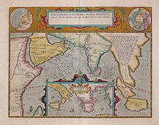 17th century map depicting the locations of the Periplus of the Erythraean Sea
 -
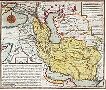
 Persian Sea.
 -
Asia. Sinus Persicus and the Mare Persicum in a very famous map published in many atlases in recent years]]
-
 Bahre Fars
 -
 Soulier, E.; Andriveau-Goujon, MER ERYTHREE 1838.
 -
 1658 Jansson Map of the Indian Ocean (Erythrean Sea)
 -
 A horizontal Malabar Coast miniature, a reprint by Petrus Bertius, 1630
 -
 The western part of the Indian Ocean, by Vincenzo Maria Coronelli, 1693, from his system of global gores the south
 -
 Persian Sea
 -
 Persia 1747


_in_Antiquity_-_Geographicus_-_ErythraeanSea-jansson-1658.jpg)


![[14]](https://commons.wikimedia.org/wiki/File:Basra-ps64.JPG?uselang=fa)
![Asia. Sinus Persicus and the Mare Persicum in a very famous map published in many atlases in recent years]]](http://en.wikipedia.org/wiki/Special:Upload?wpDestFile=580s_pictorial_map_by_Heinrich_B%C3%BCnting,_depicting_Asia_as_Pegasus.jpg)
08:00, 19 May 2021 (UTC)
References
- ^ "Ministry of MoFA Iran: Introducing a Book and Atlas". mfa.gov.ir.
Semi-protected edit request on 19 May 2021[edit]
This edit request has been answered. Set the |answered= or |ans= parameter to no to reactivate your request. |
5.211.210.253 (talk) 09:29, 19 May 2021 (UTC)
 Not done: it's not clear what changes you want to be made. Please mention the specific changes in a "change X to Y" format and provide a reliable source if appropriate. ScottishFinnishRadish (talk) 11:11, 19 May 2021 (UTC)
Expert needed?[edit]
Ibuap, would you care to explain what you mean here? I'm not sure i understand what you object to in the edit i deletion i reverted. Seems to me that a section on alternate names, especially for a body of water which has had them over the years, is reasonable ~ i am quite happy to learn and to discuss, it's just that i need to know the parameters to begin with. Thanks. Happy days, ~ LindsayHello 14:30, 4 April 2023 (UTC)
Adding Persian Sea in lead.[edit]
Firstly, as every gulf has been named after its sea, this sea is technically referred to as the Persian Sea, not that 'arabian sea'. Secondly, as a massive significant minority, all Persians around the globe and the Iranian ethnic groups and their descendants, potentially more than just that, refer to this body of water as “the Persian Sea” it is necessary and unavoidable to put the term “Persian Sea” as the lead of the article or as an alternative name for it. 151.241.254.19 (talk) 10:49, 8 April 2023 (UTC)
- C-Class vital articles
- Wikipedia level-4 vital articles
- Wikipedia vital articles in Geography
- C-Class level-4 vital articles
- Wikipedia level-4 vital articles in Geography
- C-Class vital articles in Geography
- C-Class Arab world articles
- Mid-importance Arab world articles
- WikiProject Arab world articles
- C-Class Oman articles
- Top-importance Oman articles
- WikiProject Oman articles
- C-Class Pakistan articles
- Mid-importance Pakistan articles
- WikiProject Pakistan articles
- C-Class India articles
- Top-importance India articles
- C-Class India articles of Top-importance
- WikiProject India articles
- C-Class Oceans articles
- Top-importance Oceans articles
- WikiProject Oceans articles
- C-Class geography articles
- Top-importance geography articles
- WikiProject Geography articles