Medieval Maps of Europe | 10 Magnificent Maps
Medieval maps of Europe offer a captivating glimpse into the perceptions and knowledge of the world during this era.
Medieval Map Europe 650 A.D

These maps, often intricate and beautifully crafted, reflect the medieval worldview, combining geographical accuracy with religious symbolism and mythological elements.
In an era marked by exploration and expanding horizons, these maps served as valuable tools for navigation, understanding the world, and asserting power.
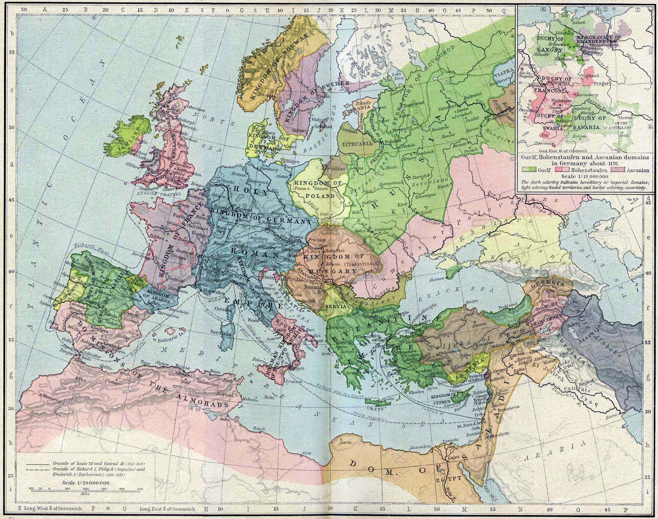
Medieval Map Europe c.1190

Embarking on a journey through the cartographic marvels of medieval Europe reveals not only the geographical understanding of the time but also the cultural, religious, and political influences that shaped the creation of these unique artifacts.
Medieval Map of Europe | Scandinavia

Medieval Map Late Medieval Period | 14th Century

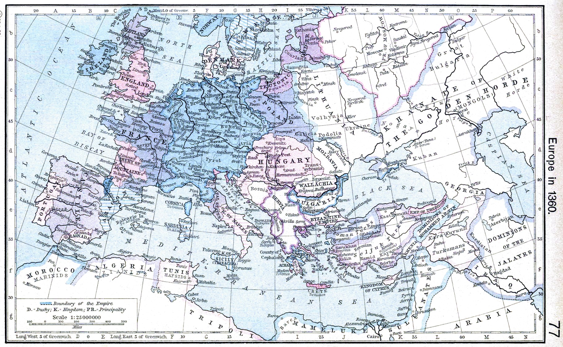
Medieval Map of Europe 1360

Medieval Map of England | William the Conquerers Reign 1087

Medieval Map of Europe 814 | Time of Death of Charlemagne

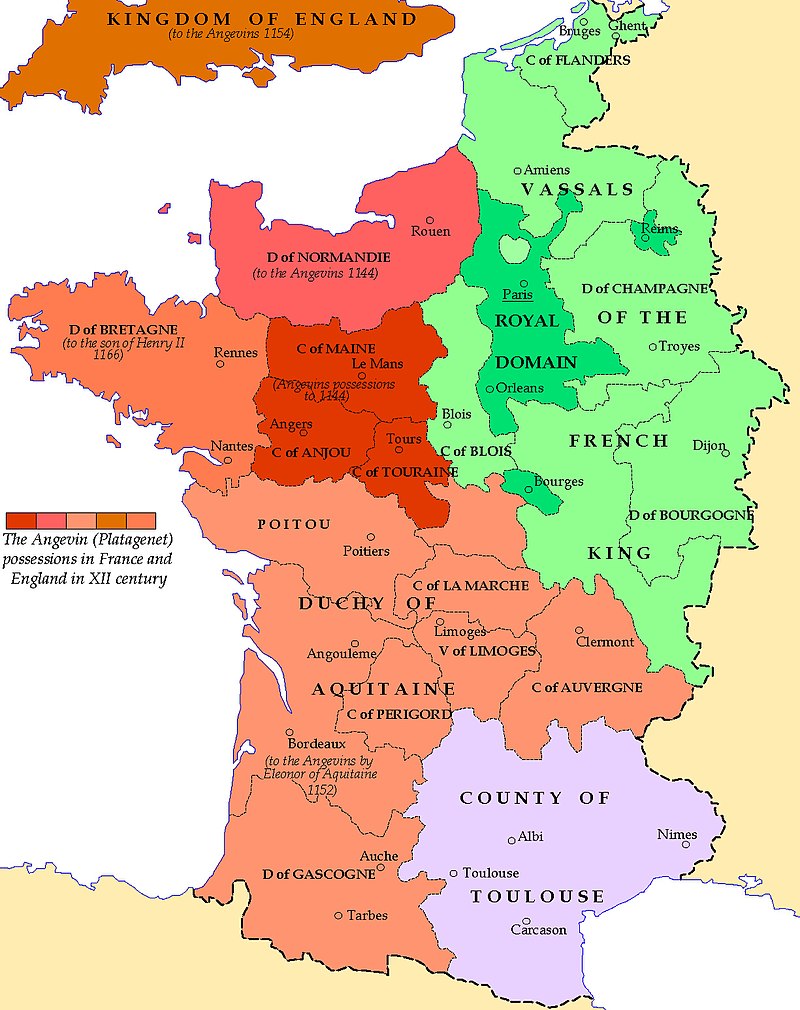
Medieval Map of France | 12th Century Angevin Empire

Medieval Maps Europe |

In the intricate lines and vivid illustrations of medieval maps of Europe, we find a testament to the human desire for exploration, understanding, and artistic expression. These maps, while reflecting the limitations of knowledge at the time, offer a window into the medieval mindset and the evolving perceptions of the world.
They invite us to marvel at the craftsmanship, imagination, and cultural influences that shaped these unique cartographic treasures. From the fantastical beasts roaming the uncharted territories to the meticulously depicted cities and landmarks, medieval maps of Europe are not only historical artifacts but also captivating works of art that continue to inspire wonder and ignite our curiosity about the past.
They remind us of the timeless human pursuit to navigate the world, both geographically and intellectually, leaving behind a legacy that still resonates in the quest for knowledge and the mapping of our ever-changing world.
- Medieval Europe
- 10 Enchanting Medieval Towns and Cities for a Romantic Valentine’s Weekend Break
- 10 Fascinating Facts About Valentine’s Day with a Medieval Twist
- 10 Key Facts about William Marshall, the “Greatest Knight”
- 8 of the Best Castles in Europe
- A Magical Journey Through Time: Top 10 Medieval Themed Places to Visit with Kids
- A Romantic Retreat: Top 10 Most Beautiful Medieval Towns in Europe for Your New Year’s Weekend Break
- Ancient Marvels: Exploring the 10 Oldest Medieval Buildings in Europe
- Austria’s Medieval Tapestry: Unveiling the Rich Heritage of People, Architecture, Customs, Wars, and Castles
- Bruges, Belgium: 10 Reasons It’s Among Europe’s Best-Preserved Medieval Cities
- Christmas in Medieval Splendor: Unveiling the Top 10 Snow-Covered Towns and Cities in Europe
- Cruising Through Christmas: Exploring Medieval Markets on European Rivers
- Discover the Medieval Marvels of Europe: A Journey through 10 Enchanting Cities
- Discovering Hungary’s Top 10 Medieval Marvels
- Dragons and Dynasties: Unveiling the Medieval Marvels of Wales
- Dynasties of Continental Europe
- Eastern Echoes: Unveiling the Medieval Enigma of Eastern Europe
- Embarking on Time Travel: Top 10 Medieval Marvels Along a Viking River Cruise
- Europe’s Top 10 Medieval Festivals: Time Travelers’ Delight
- Exploring Bergen’s Medieval Heritage: Top 5 Sites to Visit on a Viking Cruise
- Exploring Europe’s Top 10 Medieval Towns: A Tapestry of History
- Exploring Medieval Marvels: Top 10 European Sites American Tourists Adore
- Exploring Medieval Towns and Cities in Europe: Eurostar Journeys from the UK
- Feudalism in Europe
- Feudalism: Understanding the Political and Social Structure of Medieval Europe
- Haunting Histories: Europe’s Top 10 Most Eerie Medieval Towns
- How Did the Second Great Schism Help Lead to the End of Medieval Europe?
- List of Famous Continental European Kings
- Medieval England
- Medieval France
- Medieval Germany
- Medieval Ireland
- Medieval Italy
- Medieval Scotland
- Medieval Spain
- Melodies Across Borders: Top 10 Most Famous Songs in Medieval Continental Europe
- Quenching Thirsts: Exploring the Top 10 Most Popular Medieval Drinks in Continental Europe
- Radiant Jewels of Europe: Unveiling the Top 10 Exquisite Medieval Jewelry Masterpieces
- Resonating Melodies: Exploring the Top 10 Most Popular Medieval Instruments in Continental Europe
- Rise of Islam
- Rothenburg ob der Tauber: 10 Reasons It’s Europe’s Best-Preserved Medieval Town
- Sailing Through Time: Top 10 European River Cruises to Explore Medieval Towns
- Step Back in Time: 10 Castle Hotels in Europe Where You Can Experience the Medieval Period
- Step into the Past: Discover the Top 10 Places in Europe to Experience Enthralling Medieval Re-Enactments
- Switzerland in the Middle Ages: A Mosaic of Regions and Influence
- The Best Preserved Medieval Castles in Europe: A Journey through History
- The Black Death in Europe 1347
- The Norman Conquest: How William the Conqueror Changed Britain and Europe (911-1154)
- The Order of the Garter: Shaping Continental Europe in Medieval Times
- The Order of the Golden Fleece: A Symbol of Prestige and Power
- The Top 10 Greatest Medieval Knights in Europe You Need to Know About
- Timeless Elegance: Europe’s Top 10 Museums to Admire Medieval Jewelry
- Top 10 Castle Dugeons for Tourist to Visit in Continental Europe
- Top 10 Castle Hotels in Europe for a Fairytale Wedding
- Top 10 Castles in Europe
- Top 10 Family-Friendly Fun Places to Discover the Medieval Period in Europe
- Top 10 Medieval Armory Museums in Europe
- Top 10 Medieval Living Museums in Europe
- Top 10 Medieval Reenactment Groups in Europe
- Top 10 Medieval Warfare Reenactment Groups in Europe
- Top 10 Most Famous and Historically Important Medieval Cities in Europe
- Top 10 Most Famous and Historically Important Medieval Towns in Europe
- Top 10 Most Haunted Castles in Europe
- Top 10 Most Important Medieval Museums in Europe
- Top 10 Most Popular Medieval Sites in Europe With American Tourists
- Top 10 Places to Visit for Experiencing Medieval Life in Europe
- Travel Through Time: Top 10 Medieval Towns and Cities to Ring in the New Year
- Uncorking the Past: The Top 10 Medieval Wines and Where to Savor Their Timeless Elegance
- Unveiling Medieval Marvels: Top 20 Historic Sites to Explore Across the UK
- Unveiling Most Important Medieval Cities: A Tapestry of Urban Grandeur
- Unveiling the Magic: Top 10 Medieval Christmas Markets in Europe
- Unveiling the Past: Top 10 Places to Witness Medieval Siege Weapons in Action in Europe
- Viking Havoc: Unveiling the Top 10 Most Brutal and Inhumane Raids that Shattered Mainland Europe’s Peace
Main Categories
- Medieval People
- Medieval Castles
- Medieval Weapons
- Medieval Armour | Shields
- Medieval Battles | Wars
- Medieval Clothing
- Medieval Knights
- Medieval Music
- Medieval Torture
- Medieval Swords
- Medieval Food
- Medieval Life
- Medieval Times History
- Medieval Art
- Medieval Europe
- Medieval Kings
- The Crusades
- Medieval Architecture
- Medieval Period – 1000 years of Intriguing History!
