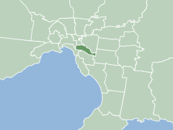
Toorak
Last updated| Toorak Melbourne, Victoria | |||||||||||||||
|---|---|---|---|---|---|---|---|---|---|---|---|---|---|---|---|
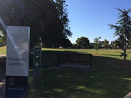 Brookville Gardens, Toorak | |||||||||||||||
 Toorak | |||||||||||||||
 | |||||||||||||||
| Coordinates | 37°50′28″S145°01′05″E / 37.841°S 145.018°E | ||||||||||||||
| Population | 12,817 (2021 census) [1] | ||||||||||||||
| • Density | 2,980/km2 (7,720/sq mi) | ||||||||||||||
| Established | 1850s | ||||||||||||||
| Postcode(s) | 3142 | ||||||||||||||
| Elevation | 32 m (105 ft) | ||||||||||||||
| Area | 4.3 km2 (1.7 sq mi) | ||||||||||||||
| Location | 5 km (3 mi) from Melbourne | ||||||||||||||
| LGA(s) | City of Stonnington | ||||||||||||||
| State electorate(s) | |||||||||||||||
| Federal division(s) | Higgins | ||||||||||||||
| |||||||||||||||
Toorak ( /ˈtuːræk/ ) [2] is a suburb of Melbourne, Victoria, Australia, 5 km (3.1 mi) south-east of Melbourne's Central Business District, located within the City of Stonnington local government area. [3] Toorak recorded a population of 12,817 at the 2021 census. [1]
Contents
- History
- Toponymy
- Toorak House
- 1880s land boom
- 1890s depression
- Post-war era
- Contemporary Toorak
- Demographics
- Housing
- Politics
- Toorak Village
- Places of worship
- Schools
- Sport
- Transport
- Residents
- Celebrities, philanthropists, cultural figures
- Politicians
- Businesspeople
- Sportspeople
- See also
- References
The name Toorak has become synonymous with wealth and privilege, the suburb long having the reputation of being Melbourne's most elite, and ranking among the most prestigious in Australia. It has the highest average property values in Melbourne, and is one of the most expensive suburbs in Australia. It is the nation's second highest earning postcode after Point Piper in Sydney. [4]
Located on a rise on the south side (or left bank) of a bend in the Yarra River, Toorak is bordered by South Yarra, at Williams Road on the west, Malvern, at Glenferrie Road on the east, Prahran and Armadale, at Malvern Road to the south and the suburbs of Richmond, Burnley and Hawthorn on the north side of the river. The suburb's main street is considered to be Toorak Road, on which the commercial area of Toorak Village is located.
History
Toponymy
Toorak was named after Toorak House, an Italianate residence built by James Jackson, a merchant, in 1849. The name of the house may have originated from Woiwurrung language, with words of similar pronunciation meaning black crow or reedy swamp. [5]
Toorak House
From 1854 Toorak House served as the residence of the first Governor of Victoria, Captain Sir Charles Hotham KCB RN and his successors, until the completion of the present Government House (1876) in the Kings Domain.
Toorak Post Office opened around June 1858. [6]
1880s land boom


During the land boom of the 1880s, many large and elaborate mansions were erected in Toorak, often in the Italianate style. Following East Melbourne and then St Kilda, Toorak, along with Brighton, became the new favored location for the wealthy.
1890s depression
The suburb was hit particularly hard by the 1890s economic depression and many wealthy landowners declared bankruptcy and were forced to sell. Nonetheless, the suburb remained and is still Melbourne's home of "old money". During the Interwar period, many houses were built in the Tudor revival style; many houses were also designed by society Architect Marcus Martin in the Moderne style over a Georgian building form. [7]
Post-war era
In the period of post-World War II prosperity, rising standards of living and land values caused Toorak to become highly sought after by a new generation of the wealthy, thought by some to be social climbers and nouveau riche. For some of these people, the focus was simply to have the postcode of Toorak, which was SE 2 and now 3142. As a result, many of the larger mansions were demolished and large holdings were subdivided to make way for flats, townhouses and apartments.
In the 1980s, larger houses in Neo-Georgian and Neo-Classical styles began to appear.
Contemporary Toorak
While large mansions have survived in neighbouring Hawthorn, Kew and Armadale, only a few of the original 19th-century mansions in Toorak remain, due in part to the high land value. Two of the most notable are Illawarra House, which was acquired by the National Trust; and Coonac, the most expensive house in Melbourne. [8] In Toorak, some of the old property names live on as street names or the names of blocks of flats, carved out of or built on their sites; Dunraven Avenue, Millicent Avenue, Iona Avenue, Woorigoleen Road, Myoora Road, and Scotsburn Grove are examples.
Demographics
In the 2016 census, there were 12,909 people in Toorak.
- 63.9% of people were born in Australia. The next most common countries of birth were China (excludes SARs and Taiwan) 3.6%, England 3.1%, New Zealand 2.2%, India 1.8% and Malaysia 1.2%.
- 73.7% of people spoke only English at home. Other languages spoken at home included Mandarin 4.5%, Cantonese 1.8%, Italian 1.4%, Greek 1.3% and French 0.9%.
- The most common responses for religion were no religion 30.9%, Catholic 17.6% and Anglican 14.9%,
- Of the employed people in Toorak, 4.0% worked in legal services. Other major industries of employment included hospitals 3.7%, real estate services 3.1%, general practice medical services 2.9% and clothing retailing 2.7%.
- The proportion of Toorak residents with a Bachelor's degree or higher is 46.7%. [9]
- The median age is 47. [10]
Housing

Toorak has an unusual mix of high-, low- and medium-density housing, due to intense subdivision of larger lots in the 1880s, 1920s and 1960s. The predominant housing in Toorak (49.6%) is apartments, particularly walk-up flats. [11]
Single-family detached homes are also prevalent (30.2%). Some of these homes are in the form of traditional mansions or newer large residences on significant-sized estates, owned by Melbourne's wealthy and social elite. The architectural style of the mansions is predominantly Italianate and colonial. There are also extant stands of semi-detached housing (20.1%), including terraces, which were traditionally fashionable with the middle class and later gentrified. [9]
Politics
Toorak falls within the federal electorate of Higgins. The seat of Higgins was created in 1949 and held by Harold Holt CH 1949–1967, Sir John Gorton PC GCMG AC CH 1968–1975, Roger Shipton OAM 1975–1990, Peter Costello AC 1990–2009, Kelly O'Dwyer 2009–2019 and Katie Allen 2019–2022 (all on behalf of the Liberal Party of Australia). However, the seat would fall to the Labor Party for the first time ever in the 2022 Federal Election, with candidate Michelle Ananda-Rajah winning the seat as Labor took government from the coalition.
At State level, it mostly falls within the electorate of Malvern (currently held by the Liberals' Michael O'Brien) since the 2006 Victorian State Election, with the western part of the suburb falling within the electorate of Prahran (currently held by Sam Hibbins on behalf the Australian Greens). At local council level, Toorak falls within the City of Stonnington.
Toorak has historically voted for conservative political parties. The Liberal Party retained the seat of Malvern in the 2018 State Election, although there was a 10.1% swing to the Australian Labor Party. [12]
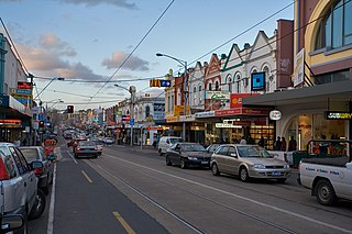
Toorak Village

The Toorak Village is a strip of shops and cafes, located centrally in Toorak Road.
Places of worship

- Saint John's Anglican Church, an 1862 Gothic Revival bluestone church, designed by William Wardell, dominates the skyline of Toorak, with a large tower including a peal of bells and a distinctive sandstone broach spire. The church was formally established at a meeting held on 21st November 1859. Those present were Messrs Alfred Ross, H.W. Dauglish, J Goodman, Allan Spowers, John Steavenson, Jas Blackwood, J Quarterman, W.M. Hammill, H.W. Farrar, George Hull, Captain Sawell, W.T. Wood, P Gunning, E Davis, J Slater, G Guillaume and son. [13] Construction began in April 1860, and was completed on 23rd October 1860. The ground for the church buildings was selected by Bishop Parry at what was the entrance to the Orrong Estate, which was the property of Mr Alfred Ross. The foundation stone was laid by the Governor, Sir Henry Barkly. [14] Saint John's, Toorak is one of the most popular wedding venue churches in Australia.

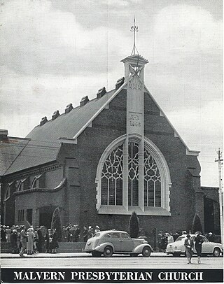
Church of St John the Evangelist, Toorak, 1934

- Saint Peter's Roman Catholic Church, built in 1876 in the Gothic style and extended in 1934. A campanile was added during renovations in 2018.
- Toorak Uniting Church (1876), in the Frenchified Gothic style
- Swedish Church
The Wesleyan Church (1877), formerly on the corner of Toorak and Williams Roads, was illegally demolished in 1990 by developers and later replaced by a block of flats.
Schools
Schools in Toorak include St Catherine's School, Loreto Mandeville Hall, St Kevin's College, Glamorgan (now Toorak Campus, the junior school of Geelong Grammar School) and Toorak Central School (1890).
Sport
The Royal South Yarra Lawn Tennis Club was founded in 1884 and is located in Toorak. Kooyong Stadium, former home of the Australian Open, is located on Glenferrie Road.
Transport

The most popular form of transport in Toorak is the automobile. CityLink runs along north eastern Toorak, though there are no interchanges within the suburb, although there is access to the freeway via MacRobertson Bridge and interchanges at Burnley. Main arterials running north–south are Williams Road (at the eastern boundary), Grange Road, Orrong Road, St Georges Road and Kooyong Road. The east–west arterials include Alexandra Avenue (at the northern boundary), Toorak Road (which runs midway through the suburb) and Malvern Road (at the southern boundary). Alexandra Avenue becomes St Georges Road and both along with Grange Road feed onto the MacRobertson Bridge, Toorak's main river crossing.
Toorak's road planning is an example of street hierarchy. As a result, there are numerous quiet pedestrian streets. However, traffic congestion is an increasing problem along Toorak Road and Williams Roads. There is limited street parking along the main roads with just a couple of multi-storey car parks and parking lots within proximity of the main Toorak Road shopping strip. There are no level crossings in Toorak. There is a perception in popular culture of the luxury 4WD as a status symbol, (controversial for their comfort rather than for their off-road abilities) [15] and this has been associated with the suburb of Toorak, such that in popular Australian culture, the term 'Toorak Tractor' has become well established in Australian slang. An example of this was an episode of the popular program Top Gear Australia , aired on SBS TV, in which the presenters, tongue-in-cheek, drove a $200,000 tractor along Toorak Road. [16]
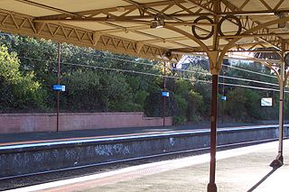
Toorak's only railway station is Heyington, on the Glen Waverley line, which crosses the Yarra from Richmond on the Heyington Railway Bridge, to the suburb's north. Despite its name, Toorak railway station is located in Armadale. The Pakenham, Frankston and Cranbourne railway line group to which this station belongs runs close to Toorak's southern boundary. Other nearby stations include Hawksburn, in South Yarra and Kooyong, in Kooyong.
Trams have run down Toorak Road since 1888. Route 58 runs along Toorak Road to Glenferrie Road, at the suburb's eastern boundary. Route 72 runs along Malvern Road, the suburb's southern boundary.
Cycling facilities are poor, with few marked on road lanes. MacRobertson Bridge and Gardiners Creek pedestrian bridge, however, the bridge provides pedestrians access to the Main Yarra Trail and shared bicycle and pedestrian paths in nearby Burnley. Pedestrians are serviced by an extensive network of footpaths and pedestrian crossings.
Residents
Celebrities, philanthropists, cultural figures
- Tina Arena AM – singer/songwriter
- Dame Zara Bate DBE – Fashion designer and wife of Harold Holt
- Martin Clemens CBE MC AM - war hero
- Albert Dadon AM – Chair of the Australian Israel Cultural Exchange
- Gina Liano – Real Housewife of Melbourne
- Paul Little AO and Jane Hansen – business people, philanthropists, Little was a former president of the Essendon Football Club
- Peter Hudson – television chef and entertainer, born in Toorak in 1930 [17]
- Eddie McGuire AM – Journalist, sports commentator, television and radio personality, Australian republic advocate and former president of the Collingwood Football Club
- Dame Elisabeth Murdoch AC DBE
- Dame Merlyn Myer DBE – philanthropist
- Sir Norman Myer – philanthropist and chairman of the Myer Emporium
- Sidney Myer – philanthropist and founder of the Myer Emporium
- Livinia Nixon – Channel 9 presenter and the Ambassador and face for the City of Melbourne-Grew up in Toorak
- Daniel Radcliffe – his family owns a house in Toorak [18]
- Susan Renouf – socialite
- Peter Robb – Australian author, born in Toorak in 1946
- Dame Hilda Stevenson DBE – philanthropist
Politicians
- Ted Baillieu – Victorian Liberal Party politician, 46th Premier of Victoria
- Malcolm Fraser AC CH – Liberal Party politician, 22nd Prime Minister of Australia
- Duncan Gillies – Colonial politician, 14th Premier of Victoria
- David Hamer AM DSC – Director of Naval Intelligence, Liberal Party Senator
- Sir Rupert Hamer AC KCMG ED – Liberal Party politician, 39th Premier of Victoria
- Harold Holt CH – Liberal Party politician, 17th Prime Minister of Australia
- Sir William Murray McPherson KBE – Philanthropist and politician, 31st Premier of Victoria
Businesspeople
- John Munro Bruce – retail businessman, father of prime minister Stanley Bruce
- Lindsay Fox AC – Former Australian Rules footballer, owner of the Linfox transportation company
- Michael Gudinski AM – Entrepreneur and businessman
- Solomon Lew – Importer and retail supplier, current resident of Toorak
- Peter Lew – managing director of Witchery clothing, son of Solomon Lew
- Keith Murdoch – journalist and newspaper owner
- Ziggy Switkowski AO – former CEO of Telstra [19]
- Sir Donald Trescowthick AC KBE
- Alex Waislitz – Chairman & CEO of Thorney Investment group, vice president of the Collingwood Football Club
- Ron Walker AC CBE – Lord Mayor of Melbourne
Sportspeople
- Nathan Buckley – Australian rules footballer, head coach of the Collingwood Football Club [20] from 2012 to 2021
- Andrew Demetriou – former chief executive of the AFL [21]
- Walter Fellows – English-born vicar who hit a cricket ball for 175 yards, considered the world record
- Lleyton Hewitt – Australian tennis player
- Clem Hill – Australian test cricketer
- James Hird – Australian Rules Footballer and former head coach of the Essendon Football Club
- Ed Langdon – AFL footballer grew up in Toorak
- Tom Langdon – AFL footballer grew up in Toorak
- Charlie McLeod – Australian test cricketer
- Lou Richards MBE – Australian Rules footballer
- Jack Saunders – Australian test cricketer
- Tup Scott – cricketer
- David Hayes- horse trainer
See also
- City of Malvern – Parts of Toorak were previously within this former local government area.
- City of Prahran – Parts of Toorak were previously within this former local government area.
Related Research Articles
The City of Stonnington is a local government area located within the metropolitan area of Melbourne, Australia. It comprises the inner south-eastern suburbs, between 3 and 13 km, from the Melbourne CBD. The city covers an area of 25.7 km2 (9.9 sq mi).
Hawthorn is an inner suburb of Melbourne, Victoria, Australia, 6 kilometres (3.7 mi) east of Melbourne's central business district, located within the City of Boroondara local government area. Hawthorn recorded a population of 22,322 at the 2021 census.

Hawthorn East is a suburb of Melbourne, Victoria, Australia, 7 km (4.3 mi) east of the Melbourne central business district, located within the City of Boroondara local government area. Hawthorn East recorded a population of 14,834 at the 2021 census.
Armadale is an inner suburb in Melbourne, Victoria, Australia, 7 km south-east of Melbourne's Central Business District, located within the City of Stonnington local government area. Armadale recorded a population of 9,368 at the 2021 census.

Kooyong is a suburb in Melbourne, Victoria, Australia, 7 km south-east of Melbourne's Central Business District, located within the City of Stonnington local government area. Kooyong recorded a population of 842 at the 2021 census.

Malvern ( ) is a suburb of Melbourne, Victoria, Australia, 8 km south-east of Melbourne's Central Business District, located within the City of Stonnington local government area. Malvern recorded a population of 9,929 at the 2021 census.

South Yarra is an inner-city suburb in Melbourne, Victoria, Australia, 4 km south-east of Melbourne's Central Business District, located within the Cities of Melbourne and Stonnington local government areas. South Yarra recorded a population of 25,028 at the 2021 census.
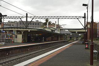
Malvern railway station is a commuter railway station that is part of the Melbourne railway network in Victoria, Australia. The station is located on the southern border of Malvern, a suburb of Melbourne, and was opened on 7 May 1879. The station complex consists of an island platform and two side platforms all accessed by a pedestrian bridge. There are two red brick Edwardian-era station buildings, constructed in 1914 as ticketing and staff offices. The entire complex is listed on the Victorian Heritage Register because of its architectural significance and its role in the development of Malvern as a significant metropolitan centre. The station is only partially accessible because of multiple steep access ramps.

Kooyong railway station is located on the Glen Waverley line in Victoria, Australia. It serves the eastern Melbourne suburb of Kooyong, and it opened on 24 March 1890.

The Division of Higgins is an Australian Electoral Division in Victoria for the Australian House of Representatives. The division covers 41 km2 (16 sq mi) in Melbourne's inner south-eastern suburbs. The main suburbs include Armadale, Ashburton, Carnegie, Glen Iris, Kooyong, Malvern, Malvern East, Murrumbeena, Prahran and Toorak; along with parts of Camberwell, Ormond and South Yarra. Though historically a safe conservative seat, Higgins was won by the Liberal Party by a margin of just 3.9 percent over the Labor Party at the 2019 election, the closest result in the seat’s history. It then flipped to Labor in the 2022 election.

The Monash Freeway is a major urban freeway in Victoria, Australia, linking Melbourne's CBD to its south-eastern suburbs and beyond to the Gippsland region. It carries up to 180,000 vehicles per day and is one of Australia's busiest freeways. The entire stretch of the Monash Freeway bears the designation M1.

Glenferrie Road is a major north–south thoroughfare in Melbourne, Australia. It runs from Kew to Caulfield North, and includes major shopping districts at both Hawthorn and Malvern. There are a number of rail transport options on Glenferrie Road and also some landmarks.
Sir Roy Burman Grounds was an Australian architect. His early work included buildings influenced by the Moderne movement of the 1930s, and his later buildings of the 1950s and 1960s, such as the National Gallery of Victoria and the adjacent Victorian Arts Centre, cemented his legacy as a leader in Australian architecture.

Gardiners Creek, originally known as Kooyongkoot Creek, is an urban stream in the eastern suburbs of Melbourne, and part of the Yarra River catchment.
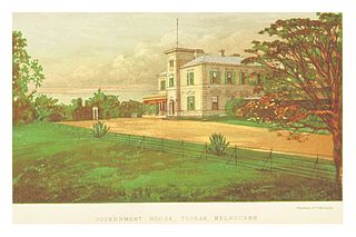
Toorak House is a mansion located in Melbourne, Australia built in 1849 by well-known Melbourne merchant James Jackson. It is notable for its use as Melbourne's first Government House and having inspired the name for the suburb of Toorak.

Como House is a historical house, with associated gardens in the City of Stonnington, Victoria, Australia. It was constructed in 1847 for Sir Edward Eyre Williams, and now serves as a tourist attraction under the custodianship of the National Trust of Australia. The gardens are open Monday to Saturday from 9am to 5pm and Sunday from 10 am to 5 pm. The historic house is open for guided tours every Saturday and Sunday.
The electoral district of Toorak was an electorate of the Victorian Legislative Assembly in the British colony and later Australian state of Victoria.
Malvern Presbyterian Church is located in Victoria, Australia. Opened in 1886, it was the first Presbyterian Church to be founded in the City of Malvern and is now within Stonnington, a metropolitan area of Melbourne.
William Arthur Purnell F.R.A.I.A., generally known as Arthur Purnell, and sometimes A W Purnell, was an Australian born architect who practiced in Canton, China in the 1900s, and from 1910 mainly in Melbourne, Australia. He is most noted for the few designs in Melbourne that include Chinese references.

Crittendens’ was a chain of grocery stores and liquor outlets operating in Melbourne, Australia, in the 20th century. The first store opened in Malvern in 1917 and the firm went on to have a total of seven retail outlets, mostly in the affluent south-eastern suburbs. The business was bought out by Myer in 1982.
References
- 1 2 Australian Bureau of Statistics (28 June 2022). "Toorak (Suburbs and Localities)". 2021 Census QuickStats. Retrieved 17 July 2022.
- ↑ "ABC Pronounce". Australian Broadcasting Corporation. 19 July 1989. Retrieved 11 May 2020.
- ↑ "Indigenous history".
- ↑ The top 10 richest postcodes in Australia 9 Finance 27 April 2018
- ↑ "Local Names". Malvern Historical Society. Retrieved 15 June 2016.
- ↑ "Post Office List". Phoenix Auctions History. Retrieved 7 February 2021.
- ↑ "42 Wallace Avenue, Toorak, Statement of Significance". Heritage Council Victoria.
- ↑ Gough, Deborah (21 November 2002). "Toorak's grandest gets new owner". The Age . Melbourne. Retrieved 15 June 2016.
- 1 2 Australian Bureau of Statistics (27 June 2017). "Toorak (State Suburb)". 2016 Census QuickStats. Retrieved 21 September 2017.
- ↑ "Toorak People & Lifestyle". Microburbs. Retrieved 11 July 2023.
- ↑ "Toorak Suburb Profile & Demographics". PropertyDATA.com.au. Archived from the original on 25 March 2019.
- ↑ "Victoria Votes, Results, Electorate: Malvern". Australian Broadcasting Corporation. 2018.