Route 66 in Lockport IL
Index to this page
Lockport IL
Information, facts and trivia
Elevation: Elevation 696 ft (212 m). Population 24,839 (2024).
Time zone: Central (CST): UTC minus 6 hours. Summer (DST) CDT (UTC-5).
Lockport is a city in Will County in northeastern llinois. It is located on the 1926-28 Route 66 and close to the later 1928-39 highway and the ALT US 66 alignment from 1940 to 1966.
History of Lockport
The first human beings reached this area some 11,000 years ago when the glaciers of the last Ice Age retreated. They were hunter-gatherer Paleo Indians. They evolved into the historic Native American groups encoountered by French explorers from Canada in the 1600s, the Illinois and Potawatome people.
In 1673, two of these explorers, Louis Jolliet and the Jesuit Missionary Father Jacques Marquette, paddled up the Des Plaines River, that runs through modern Rockport. The French incorporated the region into their North American colony of Nouvelle France ("New France"), that comprised estern Canada.
The Des Plaines was an Indian trade route as it had a short portage that linked it to the the Chicago River that flowed into the Great Lakes; read more about the Chicago Portage.
After the Seven Year War (1756-1763), France lost its Canadian colonies to England. Then, after the American Independence, what is now Illinois became a part of the U.S. In 1803 the American government established Fort Dearborn where Chicago is located.
The territory was organized as the state of Illinois and admitted into the Union in 1818. The first white settlers started arriving in the late 1820s.
Armsted Runyon, from Kentucky was the first permanent settler in Lockport, he arrived in October 1830. But moved his family to Fort Dearbon during the Black Hawk war.
Black Hawk War
The Sauk and Meskwaki (or Fox) tribes lived along the Mississippi River in what are now the states of Iowa and Illinois. The American government started to give their land to settlers and informed the natives that they should move west of the Mississippi. This triggered a war led by Sauk warrior Black Hawk. The war was short (April to August 1832) and ended with the defeat of the natives and led to the Indian Removal policy by which all Native Americans east of the Mississippi were forcibly removed to the wester side of it.
Illinois & Michigan Canal
A group of businessmen organized to build a canal to link the Great Lakes with the Mississippi River to move their farm's produce and trade with the eastern states. And allow goods to move west, linking the Great Lakes with the Gulf of Mexico via the Illinois and Mississippi rivers.
In 1825 the State Legislature incorporated the Illinois and Michigan Canal association, but the construction of the canal was delayed many years. Work started in 1836 and concluded in 1848.
Runyon quarried limestone in his farm for the building of the Iamp;M canal, he also moved from his original farm and opened a hotel in what is now Lockport.
The canal is 96 miles (154 km) long and runs through the town's business district. There is a trail along the canal's towpath (that used horses to tow the barges through the locks).
The canal linked the Chicago River across the Chicago Portage, and grain trade along the canal began as soon as it was completed, shipping it to Chicago.
In 1836 Will County was created. It was named for Dr. Conrad Will, a member of the first Illinois Constitutional Convention and member of the Illinois Legislature.
The town site for Lockport was chosen by the Canal Commissioners and it was built to house their headquarters. The company laid out the village and the first lots were sold in 1837.
There had been a Post Office in the area since 1836 at the stone mill on the western side of the river. It moved shortly after to the new town.
The name: Lockport
The town got its name from its location at the main locks of the Illinois and Michigan Canal.
A Stagecoach stop was established in Lockport in 1843. The town incorporated in 1853. The railroad reached the area in the 1850s, and a depot opened here in 1863. The railroad would gradually replace canal barges as a quicker alternative and strengthen Chicago as a trade hub.
The Chicago Drainage Canal was dug in the 1890s, parallel to the old I&M canal, to be used not only for navigation but also to send the raw sewage of Chicago westwards so that it didn't taint its drinking water supply (Lake Michigan) and help eliminate the constant cholera outbreaks.
The Pontiac Trail highway in the 1920s passed through the town and in the early 1920s, State Highway 4 was built from Chicago through Joliet and carried US 66 in 1926, it went through Lockport until the highway was rerouted in 1928.
The canal closed in 1935.

Accommodation near Lockport
> > Book your hotel in neighboring Joliet
Find More Accommodation near Lockport along Route 66
Hotels east of Lockport
- 10 mi. Plainfield
- 4 mi. Romeoville
- 9 mi. Bolingbrook
- 15 mi. Willowbrook
- 24 mi. Lyons
- 35 mi. Chicago
- SW Suburbs of Chicago
More hotels, heading West
- 5 mi. Joliet
- 22 mi. Wilmington
- 45 mi. Dwight
- 64 mi. Pontiac
- 76 mi. Chenoa
- 101 mi. Normal
- 103 mi. Bloomington
- 124 mi. Atlanta
- 133 mi. Lincoln
- 167 mi. Springfield
>> See the RV campground in Joliet or nearby in Braidwood
The Weather in Lockport
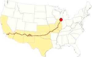
Map showing the location of Lockport, Illinois on U.S. 66
Lockport's climate is of the humid-continental type and it has four distinct seasons; summers are damp and hot, fall is mild, spring is wet and cool, and winters are cold.
The average winter (January) high temperature is 32°F (-0°C); while the average low is 17°F (-8.6°C). During summer (Jul) the averages are the following: high, 84°F (29°C) and low, 64°F (17.7°C).
Rainfall averages 3 to 4.3 (78 and 110 mm) inches per month between April and November. The rest of the year has less rain, with 1.7 in. (28 mm) monthly. On average, the town gets 37 inches of rain each year (940 mm).
Snowfall is around 28 inches (71 cm), with the first snow falling in November. It can snow in April. There is usually no snow between May and September.
Tornado risk
The area that surrounds Lockport gets some 4 tornado strikes every year. Tornado Risk: read more about Tornado Risk on US 66.
The Maps of Route 66 in Lockport IL
>> Our Custom map shows the alignments of U.S. 66 in Lockport.
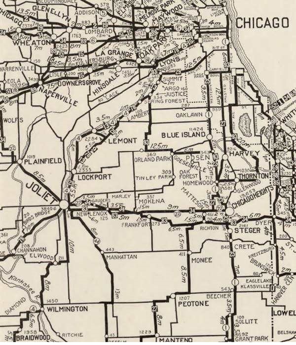
The map above was published in 1924, two years before Route 66 was created. It displays the "Auto Trails" or roads that could be driven by cars. The ones close to Rockport are marked with numbers: as "34" for the "Lincoln Highway" through Joliet and Plainfield, or "13" for the "Mississippi Valley Highway" from Lyons, through Lockport. The number "4" inside a white circle is State Highway 4.
State Highway 4

Creation of State Hwy. 4, Illinois. Source
Illinois funded its original state highway network by floating a bond in 1918. Among the roads built was SBI 4 (State Bond Issue Route 4) that was aligned along what had been the "Pontiac Trail" that ran from Chicago to St. Louis. Originally it was aligned to the northeast of Joliet, by the Collins Street State Prison, to Lockport, and then curving along the Des Plaines River eastwards into Lemont, Argos and Summit, where it crossed the river and canal to enter Lyons.
Route 66's first alignment in 1926
Route 4 was paved completely by 1923 so it was the logic choice for the alignment of Route 66. Both highways overlapped until the signs of the old state higway were finally replaced by the U.S. 66 shields in 1927.
This means that Route 66 ran through Lockport even though we have not been able to find maps showing this alignment.
Several Route 66 books mention this Lockport alignment James Powell in his book about the 1928 Bunion Derby states that the foot race went through Lockport's main street as a "temporary 66" was aligned along it in the Spring of 1928 while the main alignment was being built further west (from Joliet through Romeoville).
David G. Clark, also supports the idea of a temporary Route 66 through Lockport along State Hwy 4.
The City of Lockport on its website confirms that Route 66 was aligned along State Street in 1926.

1928 Illinois State roadmap (see State Hwy 4A). Source
Click map to enlarge
Route 4A and the new Route 66 alignment (1928?)
But soon the new roadway that ran along the north and western side of the Des Plaines river in a straighter course across open countryside with farms and fields (the current town of Countryside on this alignment got its name for this reason). The new alignment avoided the urban crossings of Summit, Justice, Argo, Lemont and Lockport; it also eliminated many sharp curves and turns.
The new alignment was re-designated as both US 66 and Route 4. The old alignment was designated as Route 4A. You can see it in the map (click to enlarge).
Temporary U.S. Highways
The map gives some credence to a possible temporary alignment of Route 66. You can see U.S. 45 designated as T 45 through Joliet along the new Route 4, while the definite alignment was being built further east (see the two US 45 shields, one south of Summit, the other east of Manhattan). US 32 also shows a T 32 alignment at Aurora.

1927 Chicagoland map. Source
Click map to enlarge
The 1927 map of Chicagoland shows both Route 4 and 4A the thumbnail image (click to enlarge) shows them from Lyons to Joliet. Notice the many curves and turns along 4A vs. Route 4. Both start in Cicero and meet in Joliet after splitting in Lyons.
Maps of the different alignments
The color keys to the alignments and a brief description of each one is given below.
Map with US 66 alignments in Lockport
The bordeaux color line is the one described further up, the "Temporary 66" aligned along the south and eastern sides of the Des Plaines River along the original IL-4 highway. Used from 1926 to 1928.
In 1928 it was realigned along the north and western side of the river (pale blue line in our map), and carried U.S. 66 from 1928 to 1940.
South of Joliet, the 1926-40 Route 66 is shown with a red line.
Realignment of Route 66 through Plainfield, this took place in 1940 (yellow line south of Plainfield and red line east of it). The older alignment became ALT 66.
The ALT 66 alignment remained in use until February 1967 when it was replaced by Illinois State Highway 53 from Welco Corners to Gardner.
In 1958 US 66 was moved east west to a brand new freeway that now bypassed all the towns including Plainfield, Braidwood and Gardner. US 66 and I-55 shared the freeway until 1977; see the violet lines in our custom map from Gardner and east of Plainfield.
The old Route 66 is a Historic highway and has also been designated as a National Scenic Byway and an All-American Road in the state of Illinois.
The Route 66 alignments near Lockport
Description and interactive maps of US 66.
- Pontiac to Springfield (next)
- Chicago to Pontiac (Lockport's)

Lockport's Route 66 Landmarks and Attractions
What to see in Lockport
US 66 in Lockport: historic context
Jack DeVere Rittenhouse published his "Guide Book to Highway 66" in 1946 describing the highway from Chicago to Los Angeles. He does not mention Lockport because he drove the "Main US 66" through Plainfield, further west.
The WPA's guide to the state of Illinois published in 1939 in its Tour 22 describes the area as follows:
At LOCKPORT (L) 34.5 m. (582 alt., 3,383 pop.), once an important shipping and transfer point on the Illinois and Michigan Canal, is the lock that controls the volume of water withdrawn from Lake Michigan. Here were the offices of the canal company, among whose records are preserved many documents pertaining to the days of the canal's construction and operation. These include maps, field notebooks, correspondence, newspapers of a century ago in which bids for canal contracts are advertised, and such miscellaneous records of the disbursing office as the pork and flour contracts for 1838-39. Among the items is a prospectus of the Illinois Central Company offering for sale, in 1855, 2,400,000 acres of "selected proven farm and woodlands in tracts of any size to suit purchasers, on long credit at low rates of interest, situated on each8 side of the railroad, extending all the way from the extreme North to the South of the State of Illinois." WPA (1939)
Route 66 Road Trip Leg in Lockport
We describe this leg driving westbound from Romeoville since there are no remains of the 1926-28 Route 66 landmarks north of Lockport towards Lemont, Summit and Lyons.
Drive south along Route 66 for 3.7 miles, and at the intersection with State Hwy. 7 turn left and head east to cross the Des Plaines river. It is just one mile to Lockport (map with directions).
Des Plaines River
The river is 133 miles (214 km) long and flows southwards from Wisconsin and when it approaches Chicago and Lake Michigan, it takes a southwestern course. It passes by Lockport and further South it meets the Kankakee River to form the Illinois River, that in turn flows into the Mississippi River.
The French named it after the trees that grew along its course; it was "La Rivière des Plaines," the River of the Plane Trees. They called the American sycamore and the red maple after the European plane tree which they resembled.
The bridge on Highway 7 crosses the meandering Des Planes River and next to it, the 200-feet wide (60 m) and straighter Chicago Sanitation and Shipping canal. The bridge also crosses one set of railroad tracks and ends at Canal St., one block west of the old Illinois & Michigan Canal. Continue straight along 9th St. and cross the I&M canal to enter the town's Historic District. On the eastern side of the bridge you can park and visit the local sights.
Lockport Historic District
Listed in the National Register of Historic Places
The district spans the area between State St., the canal, 8th St. and 11th St. It has many buildings built before the Civil War. After a fire in 1895, the eastern side of State Street was rebuilt between 9th and 10th Streets the following year. Enjoy the sandstone and red brick buildings typical of the late 1800s.
William Gooding silhouette marker
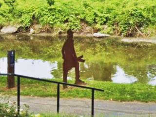
Right beside the canal, on the south side of 9th St. bridge, on the I&M towpath beside the parking lot. The steel silhouette remembers William Gooding (1803-1878) Chief Engineer during the canal's construction. He was self-taught! This canal and its locks were built using men and horses, no steam-powered machinery was used to excavate the canal across rock, hills and swamps. It was quite a feat. He lived and worked in Lockport, he designed the hydraulic basin here that supplied water power to move the wheels at the flower and paper mills as well as the tannery.
Lincoln Landing
On the north side of 9th St. is the Lincoln Landing, a two-acre park and museum. Dedicated on the 200th Anniversary of Abraham Lincoln’s Birthday, it has a bronze statue of a Lincoln in three dynamic poses set on the site of the original canal wall. Originally, it was wider than it is now; some 60 feet - 20m wide and 6 feet deep (1.8 m).
Lincoln was an ardent supporter of the I&M Canal. He announced the opening of the canal on the floor of Congress in 1848 proudly informing that "... we were all gratified to learn, among other things, that sugar had been carried from New Orleans through this canal to Buffalo in New York." He traveled along it that same year, and is said to have dined with William Golding here in Lockport.1
Gaylord Building
Listed in the National Register of Historic Places
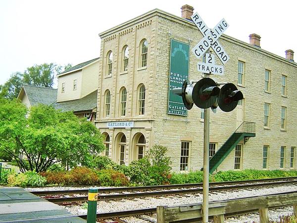
Just one block north at 8th St. and the railroad, at the northern tip of Lincoln Landing at 200 W 8th St, is the historic Gaylord Building.
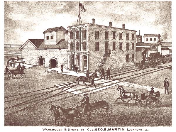
The structure to the left (west) was built in 1838 and designed by Erastus and William Newton with a partial 3rd story added in 1859. The stone building to the right, by the tracks was also added in 1859. It was built as a warehouse on the I&M canal and owned by George Gaylord (1820–1883), a Lockport merchant for several yers. The engraving below shows it in the late 1800s and is captioned "Warehouse & Store of Col. Geo. B. Martin Lockport Ill."
The 1891 Sanborn map shows it as the Barrow Mfg., a plant that produced bronze and builders hardware.
Gaylord Building nowadays, Lockport, Illinois
Turn right along 8th St. and on the SW corner with State St. is the museum, housed in the original Canal Headquarters.
State Street was Route 66's alignment in Lockport
The street carried the stagecoach line and later the Pontiac highway. It became the paved State Highway Route 4 in 1923, and Route 66 was aligned along it from 1926 to 1928 as a temporary alignment. The Ward Hotel stood at State 935 in 1940.
Norton Building
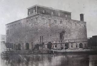
Norton Building 1873, Lockport IL. Source. Click to enlarge
Walk south along State Street southwards, at 10th St, one block to your right, by the canal is another ancient building at 201 West 10th St. (Street view).
It houses the Illinois State Museum-Lockport Gallery. Built ca.1850 in limestone it was Hiram Norton's grain storage building with a capacity for 200,000 bushels. An old grain elevator. A suspended bridge spanned the canal here. There was also a tunnel underneath the canal that took water discharged from a turbine and used it to move machinery at the grain elevators, and the corn shelling and planing mill next to them.
Norton also built water powered flour and paper mills along by the large hydraulic basin on the west side of the canal. The economic crisis of the 1890s hurt the company that failed in 1896 and finally closed in 1907.
Roxy Theater
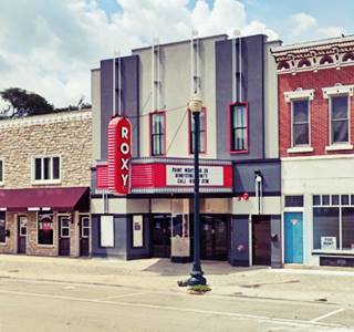
Continue along State St. To your right at 1017 State St. is the Roxy Theater that opened in 1937.
The site originally housed Norton's Livery building. It could seat 400 spectators. It has a classic marquee.
Ahead on the same block are two Route 66 landmarks.
Mackin Motors
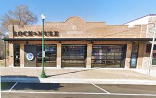
The red brick building that housed Mackin Motor Co. at 1025 S State St. is still standing, now repurposed as Lock & Mule, a restaurant with Tangled Roots Brewing Co.'s artisanal craft beers.
Mackin was an automobile dealership and had a garage and a gas station. The south side of downtown Lockport was the center of automotive businesses.
Notice the stone inset in the stepped parapet with "19 MACKIN 27" written on it. This place was contemporary to Route 66 running along State Street in front of it.
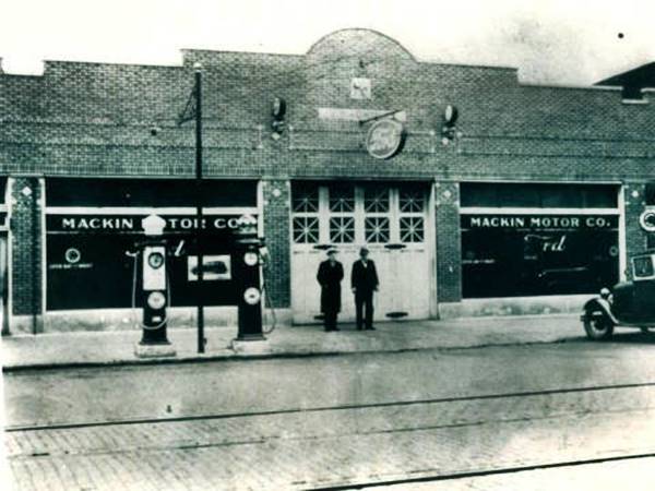
Pure Oil gas station
There were several gas stations on this block and at 11th St. The image (click on it for a full sized view) shows a late 1930s view with the Roxy on the right, followed by Mackin selling Standard Oil (Mackin appears in the 1940 phone directory), a Mobil next to it on the NW corner of 11th St. and a Texaco on the SW corner. On the SE corner in the Adelmann Block building, that is still there, the livery had been converted into a Aldemann Motor Sales & Service Co, that operated from the early 1900s until 1961.
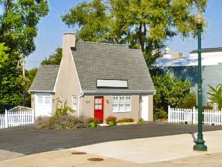
The Mobil station next to Mackin at 1035 S State was replaced by a Pure Oil station, a cottage-style building dating back to 1928 according to the Lockport City website. It is still standing, after being renovated in 1994.
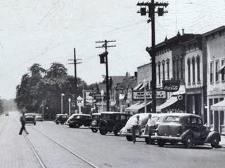
Late 1930s view along State St. Lockport. Source. Click image to enlarge
The Texaco across 11th St. on the SW corner has gone, but the current used car lot (Warren's Auto) at 1101 S State has the appearance of a 1950s service station with two service bays and a corner office (street view).
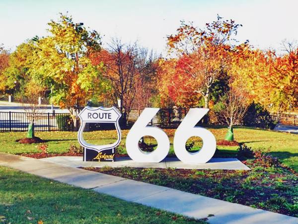
Lockport Route 66 Centennial Community Monument
Three blocks ahead, to your right, is a modern Route 66 attraction and it is a great spot for a Route 66 selfie. Located at the north tip of the Metra parking space opposite 14th Street.
It is one of many along the Mother Road sponsored by the Heritage Corridor Bueau using a $1.5 million grant from IL DCEO designed to enhance sites along Route 66 ahead of the Route 66 Centennial (1926-2026). You can find them in Joliet, Burr Ridge, Willowbrook, Romeoville, Gardner, Dwight, Pontiac, Bolingbrook, Countryside, and Plainfield.
Barnsdall station
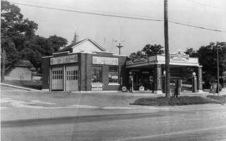
1930s view Barnsdall station in Lockport. Source. Click image to enlarge
There is a final attraction in town that seems to date back to the late 1920s, possibly to the Route 66 days. Located on the SE corner Division and State streets, two blocks south of the Centennial marker.
Theodore N. Barnsdall established the Barnsdall Oil Company on January 1, 1922. The gas station in the image has a flat canopy over the pumps and two service bays facing Divison St. The image (click on it to enlarge) shows the street was either cobbled or paved with bricks, and that it had the track of the tramline running along it. This is the Street view of the garage that stands on the spot with more service bays facing Division St.
Lock #1 on the Canal
One block west, is the canal and the Lock #1 of the canal. It allowed vessels to move upstream between stretches of water of different levels. Between 15 and 45 boats passed by these locks every day in the 1860s when the canal was busiest, and it took 15 minutes for each one to go through. The lock was built in 1840, south of the large basin where "the canal must be about 200 or 250 feet in width at the bottom, and the locks and abutments are laid in smooth handsome masonry."2
Continue your Road Trip
This is the end of your Route 66 Road Trip across Lockport, return to Route 66 by taking 9th Street, turn left and head westbound into the next town in your itinerary, Joliet, to continue your journey.

Sponsored Content
>> Book your Hotels in Illinois

Credits
Banner image: Hackberry General Store, Hackberry, Arizona by Perla Eichenblat
Jack DeVere Rittenhouse, (1946). A Guide Book to Highway 66.


