Wake Island
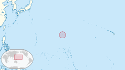
Wake Island is a tiny island in Micronesia in the Pacific Ocean, located 2/3 of the way from Honolulu to Guam, best known for its role in World War II. It is an unorganized United States territory, with no permanent residents, just members of the U.S. military and civilian contractors who manage the facility. Positioned just a few hundred miles west of the International Date Line (UTC +12), Wake Island is "in the future" from most of the world, and the rest of the United States. Understand[edit]Landscape[edit]"Wake Island" is technically an atoll of three islands: Wake itself is V-shaped; Wilkes and Peale Islands are extensions of the legs of that V, separated from Wake by narrow channels. They surround a shallow lagoon and are themselves surrounded by a coral reef. The highest point is only 20 ft above sea level. The islands cover about 12.5 mi2, with a coastline of 12 mi. The island's airfield, including a runway running the length of the southern leg of the V, covers a substantial percentage of the land area. History[edit]The island was first discovered in 1568 by a Spanish explorer who named it San Francisco. A British ship captained by Samuel Wake re-discovered it more than 200 years later in 1796, and the island was subsequently named after him. The 1840 United States Exploring Expedition led by Charles Wilkes with naturalist Titian Peale gave their names to the smaller islands. But it was Pan American Airways that put it on the map, building a PAAville and a 48-room hotel on Peale Island and using it as a refueling and rest stop on their then-new "China Clipper" passenger and mail route between San Francisco and Hong Kong in 1935. The island served as a connecting point between Guam and Midway Island. Japan attacked Wake Island just hours after its Pearl Harbor, Honolulu attack (December 8 local time, due to the time difference), then laying siege to Wake over the next few weeks. They successfully took the island, but not before the smaller U.S. military and civilian forces there sank two Japanese destroyers (one with shore batteries and one by air), sunk a submarine, substantially damaged their other ships, and killed nearly 1000 of the invading Japanese forces. Eight months later, Wake Island, a stirring dramatization of the island's defense, was released by Paramount Pictures, garnering four Oscar nominations, including Best Picture. The island returned to U.S. control following the Japanese surrender (although there is now a conflicting claim by the Marshall Islands, which became independent in 1986). It has since served as a refueling stop and staging ground during the Korean War, the Vietnam War, and Operation Desert Storm. It served as a waystation to the U.S. for 92,000 Vietnamese refugees in 1975, and evacuees of the 1991 eruption of Mt. Pinatubo in the Philippines. It currently participates in the testing phase of possible ballistic missile defense systems. Wake Island was struck by Super Typhoon Ioke, a Category 5 tropical storm, in August 2006. The atoll's population of 188 was fully evacuated. Seventy percent of the buildings were damaged, but not as badly as feared, and major components of the island's infrastructure survived, including the airfield. As of August 2007, the island was up and running again. Get in[edit]Entry into Wake Island is heavily restricted, and requires a special use permit to visit, often from the U.S. military or the US Fish and Wildlife Service. Both generally give permits only to military personnel and civilian contractors. This even applies to U.S. and American Samoan citizens. Commercial air service to Wake has been discontinued, and the atoll is no longer generally open to visitors. The airstrip remains available as an emergency landing site for trans-Pacific flights. If you don't have official business there, that's the most likely circumstance in which you'll visit the place. In non-emergency situations, a Prior Permission Request must be filed to use the airstrip (and will probably be denied) +1-808-424-2101. From time to time, Military Historical Tours [1] offers day trips to the island. They include a flight from Guam on a chartered Continental Micronesia 737-800. The island does not have a navigable harbor. The lagoon is cut off from the ocean by a coral reef, and it is rarely deeper than a few meters at high tide. Get around[edit]Most parts of the islands are easily accessible on foot, though sturdy shoes are recommended to protect from sharp coral rocks in many places. There are also roads on the islands; trucks, minivans, and full-size vans are available to authorized personnel. +1-808-424-2227. See[edit]
Do[edit]Note: You need a special permit from You have to ask US Military or US Fishing and Wildlife Services for the permit. The best periods for the trip is from May to December. Wake Island does provide an economical structure, including houses, dorms, and a 24-Hour Gym in the Downtown Area managed by both the U.S. Military and U.S. Fish and Wildlife Service. Buy[edit]Eat[edit]Drink[edit]
Sleep[edit]
Work[edit]The facilities on Wake Island are managed by the civilian Chugach Alaska Corporation, 3800 Centerpoint Dr., Anchorage, AK 99503 +1 907-563-8866. [2] Stay safe[edit]Sharks swim in the waters of the Pacific around Wake Island. Wake Island has no natural fresh-water sources, so huge catchbasins for rainwater were built but are no longer in service. Water now is made through reverse osmosis processing units that pull salt water from the ocean and convert it to potable water. Get out[edit]Depending on the direction, either Guam or the Midway Islands was the next stop on Pan Am's "China Clipper" route, both of which also played important roles in World War II. The Marshall Islands are the atoll's nearest neighbor, a few hundred miles to the south.
|
|
|||||||||||||||||||||||||||||||||||||


