Weather | channel3000.com Skip to main content
First Warn Weather, Madison's certified most accurate forecast by WeatheRate

Forecast Update

ALERT DAY on Sunday for Rain / Afternoon Storms - Buddy

May 25, 2024 @ 7:30 pm

Clouds will increase overnight and ALERT DAY conditions expected Sunday.  Click for the latest ALERT DAY details.

Plan My Day

Today
73°F
Considerable cloudiness. Lows overnight in the mid 50s.
Tonight
61°F
Increasing clouds and a little warmer. Wind: SE 5-10 MPH
Tomorrow
67°F
Thunderstorms. Highs in the mid 60s and lows in the low 50s.

CUSTOMIZE YOUR FORECAST

Adjust the ZIP code in the box below to get the forecast for your town

Madison, WI

Right Now
63°
Clear
  • Humidity: 81%
  • Feels Like: 63°
  • Heat Index: 63°
  • Wind: 2 mph
  • Wind Chill: 63°
  • UV Index: 0 Low
  • Sunrise: 05:25:11 AM
  • Sunset: 08:25:34 PM
  • Dew Point: 57°
  • Visibility: 10 mi

Today

Partly sunny and mild. Wind: W 5-10 MPH

Tonight

Increasing clouds and a little warmer. Wind: SE 5-10 MPH

Tomorrow

Mostly cloudy, breezy, and cooler with periods of rain and scattered thunderstorms. Heavy rainfall is possible. Wind: E 10-20 MPH

Next 12 Hours

Time
Temp
Precip
10 PM
63°
0%
10 PM
63°

Wind: SSE @ 2 mph

Precip: 0% Chance

Humidity: 79%

Wind Chill: 63°

Heat Index: 63°

UV Index: 0 Low

Visibility: 10 mi

11 PM
62°
0%
11 PM
62°

Wind: SE @ 4 mph

Precip: 0% Chance

Humidity: 80%

Wind Chill: 62°

Heat Index: 62°

UV Index: 0 Low

Visibility: 10 mi

12 AM
61°
0%
12 AM
61°

Wind: SSE @ 6 mph

Precip: 0% Chance

Humidity: 75%

Wind Chill: 61°

Heat Index: 61°

UV Index: 0 Low

Visibility: 10 mi

1 AM
61°
0%
1 AM
61°

Wind: SSE @ 6 mph

Precip: 0% Chance

Humidity: 66%

Wind Chill: 61°

Heat Index: 61°

UV Index: 0 Low

Visibility: 10 mi

2 AM
60°
0%
2 AM
60°

Wind: SE @ 6 mph

Precip: 0% Chance

Humidity: 63%

Wind Chill: 60°

Heat Index: 60°

UV Index: 0 Low

Visibility: 10 mi

3 AM
58°
0%
3 AM
58°

Wind: SE @ 5 mph

Precip: 0% Chance

Humidity: 66%

Wind Chill: 58°

Heat Index: 58°

UV Index: 0 Low

Visibility: 10 mi

4 AM
56°
10%
4 AM
56°

Wind: SE @ 6 mph

Precip: 10% Chance

Humidity: 70%

Wind Chill: 55°

Heat Index: 52°

UV Index: 0 Low

Visibility: 10 mi

5 AM
54°
10%
5 AM
54°

Wind: SE @ 6 mph

Precip: 10% Chance

Humidity: 66%

Wind Chill: 52°

Heat Index: 50°

UV Index: 0 Low

Visibility: 10 mi

6 AM
54°
20%
6 AM
54°

Wind: ESE @ 6 mph

Precip: 20% Chance

Humidity: 64%

Wind Chill: 52°

Heat Index: 50°

UV Index: 0 Low

Visibility: 10 mi

7 AM
56°
50%
7 AM
56°

Wind: ESE @ 7 mph

Precip: 50% Chance

Humidity: 66%

Wind Chill: 53°

Heat Index: 52°

UV Index: 0 Low

Visibility: 7 mi

8 AM
58°
60%
8 AM
58°

Wind: SE @ 6 mph

Precip: 60% Chance

Humidity: 69%

Wind Chill: 57°

Heat Index: 58°

UV Index: 1 Low

Visibility: 6 mi

9 AM
57°
60%
9 AM
57°

Wind: ESE @ 7 mph

Precip: 60% Chance

Humidity: 74%

Wind Chill: 55°

Heat Index: 57°

UV Index: 1 Low

Visibility: 5 mi

Radar

Radar Loops and Maps

Weather News

AP

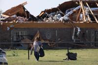
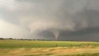
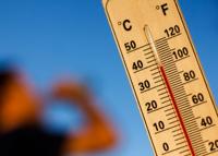
Forecasters are warning of another day of heightened risk of dangerous tornadoes in the Midwest. They also are telling people in south Texas it may feel like close to 120 degrees almost four weeks before summer starts. The weather service in Oklahoma is comparing Saturday to a gasoline-soaked pile of brush. Forecasters aren’t certain storms will form, but any that do will explode with large hail, dangerous winds and tornadoes — like putting a match to that brush pile. Excessive heat, especially for May, is the danger in south Texas, where the heat index is forecast to approach near 120 degrees Fahrenheit (49 degrees C) during the weekend.

AP featured top story

Several tornadoes have been reported in Iowa and Illinois as storms downed power lines and trees. Friday's severe weather comes days after a tornado devastated one small Iowa town, killing four people and injuring 35 others. The latest storm system began overnight in Nebraska before traveling across central Iowa and into Illinois. A meteorologist with the National Weather Service in Des Moines says strong, straight-line wind gusts equivalent to the speed of a weak tornado were recorded across Iowa. The weather service says at least five tornadoes were reported south of Iowa City and near Moline, Illinois. No injuries had been reported.

AP top story

Residents in Omaha, Nebraska, awoke to weather sirens blaring and widespread power outages early Tuesday morning. That came around 6 a.m. Tuesday as torrential rain, high winds and large hail pummeled the area. More than 10,000 customers were without power in and around Omaha as more than 5 inches of rain in less than two hours saw basements flooded and cars submerged in low-lying areas. National Weather Service meteorologist Becky Kern says a wind gust of 90 mph was recorded west of Omaha in the city of Columbus. Severe storms are expected to move into Iowa, Minnesota, Illinois and parts of Missouri later Tuesday.