Atlas of Austro-Hungarian Empire
Table of Contents
This post may contain affiliate links. As an Amazon Associate, we earn from qualifying purchases.
Austria-Hungary was a union between the Austrian Empire and the Kingdom of Hungary. A third component was Croatia-Slavonia. From 1878 Empire jointly ruled Bosnia-Herzegovina, which it joined in 1908. This great power existed in the heart of Europe from 1867 to 1918.
Austria-Hungary was the 2nd-largest nation in Europe after Russia (621.5 thousand sq km / 240 thousand sq mi) and the 3d-most populous after the Russian and the German Empire. The empire was split into 3 regions with a percentage of population: Austrian lands (56%), Hungarian lands (41%), Bosnia and Herzegovina (3%). It was a mighty empire whose non-existent borders can be traced even today.
Austria-Hungary had a well-developed railroad network that helped control the vast empire. It was easier to get around much of the region then than now.
Isochrone Map of the Austro-Hungarian Empire Railway Network (1912)

Austria-Hungary Empire was a multinational country. The Empire built up the 4th-largest machine-building industry globally, behind the U.S, Germany, and the U.K.
Ethnic groups of the Austro-Hungarian Empire (1910)
Below the map are the ethnic groups of Austria-Hungary in 1910, according to Distribution of Races in Austria-Hungary by William R. Shepherd, 1911. It was one of the most ethically diverse nations in human history.

The Austro-Hungarian Empire had a population of almost 53 million people who talked the following languages:
German: 23.4%
Hungarian: 20.0%
Czech: 12.5%
Serbo-Croatian: 10.9%
Polish: 9.9%
Ruthenian: 7.8%
Romanian: 6.3%
Slovak: 3.8%
Slovene: 2.4%
Italian: 1.5%
Other: 2.1%
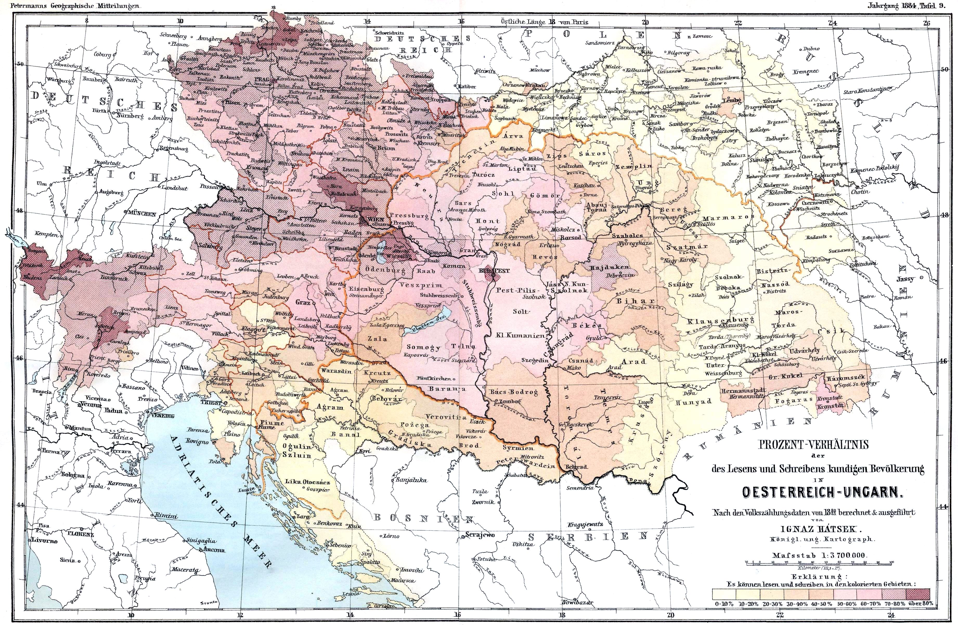
Literacy in Austria-Hungary (1880)
In 1910, in the western Austrian provinces, literacy exceeded 90 percent; in Hungary, not yet 50%, ranging from west to the east, between 70 and 30%.
Typically, rural settlements have lower levels of literacy than urban populations.
Life expectancy in Austria-Hungary was about 40 at the end of 19 century. But teen marriage wasn’t typical, even for women. In the red zones (mostly catholic Austria) on the map below, created by Reddit user Tylacin, average age at marriage might be even higher than today, especially for men.
Age at marriage in Austria-Hungary

Six ways to split the Austro-Hungarian Empire in 1900 according to Austro-Hungarian imperial propaganda.
This map created by Reddit user CountZapolai is a deliberately light-hearted effort to explain how the Hapsburg monarchy perceived its Empire between 1880 and 1914. Rule of funny is in effect rather than complete accuracy.

You can read more about this Empire from the following books: