Map of the United Kingdom
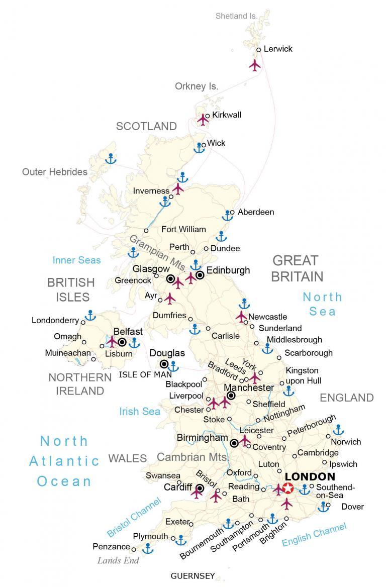
This United Kingdom map shows the four countries – England, Scotland, Wales, and Northern Ireland. It includes a satellite and elevation map of the United Kingdom that shows its topography and highest peak.
You are free to use our United Kingdom map for educational and commercial uses. Attribution is required. How to attribute?
About the map
The United Kingdom is an island in western Europe and part of the British Isles archipelago. It’s located northwest of France and east of Ireland. Great Britain consists of the countries of England, Scotland, and Wales.
The United Kingdom includes Northern Ireland and many smaller nearby islands. Their total areas can be divided into England 53%, Scotland 32%, Wales 9%, and Northern Ireland 6%. It’s situated in the Atlantic Ocean with the Irish Sea and Inner Seas on the west, and the North Sea on the east coast.
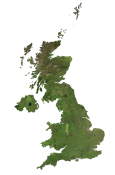
SATELLITE IMAGERY
United Kingdom Satellite Map
The United Kingdom occupies an area of 242,495 square kilometers (93,628 sq mi). In size, this is less than the total area of Michigan but larger than Romania. London is the capital and largest city of the United Kingdom with about 9 million people.
This is the location where the Royal Observatory, Greenwich, is the defining point of the Prime Meridian. The Thames River flows through southern England into London. It’s the longest river in England at 215 miles. But River Severn is the longest river in all of the United Kingdom.

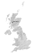
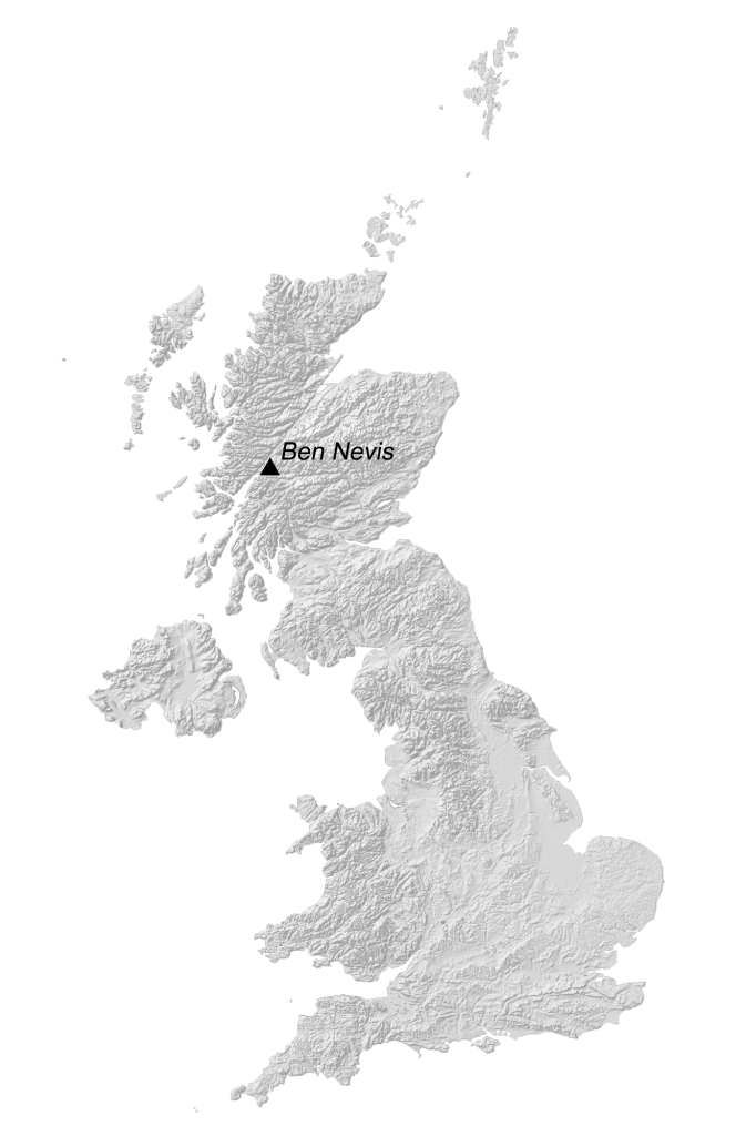
PHYSICAL MAP
United Kingdom Elevation Map
The terrain in the United Kingdom is mostly rugged hills and low mountains. Then, it transitions to rolling plains in the east and southeast. The highest point in the United Kingdom is the Ben Nevis summit, which stands 1,345 meters in height above sea level.
This mountain peak is located in the Scottish Highlands, a sparsely populated area in the northwest of the United Kingdom. Whereas the Cambrian Mountains are a series of mountain ranges located in the southern region of Wales.
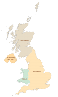
POLITICAL MAP
United Kingdom Countries Map
The United Kingdom is a sovereign nation situated in northwestern Europe. It is composed of four distinct and historically rich constituent countries: England, Scotland, Wales, and Northern Ireland. These four nations, each with their own unique culture, history, and identities, come together to form a cohesive and diverse union.
These four countries, though united under a single political entity, maintain a sense of autonomy and individuality. The United Kingdom’s unity is maintained through shared institutions such as the British monarchy, the British Parliament, and common foreign and defense policies.
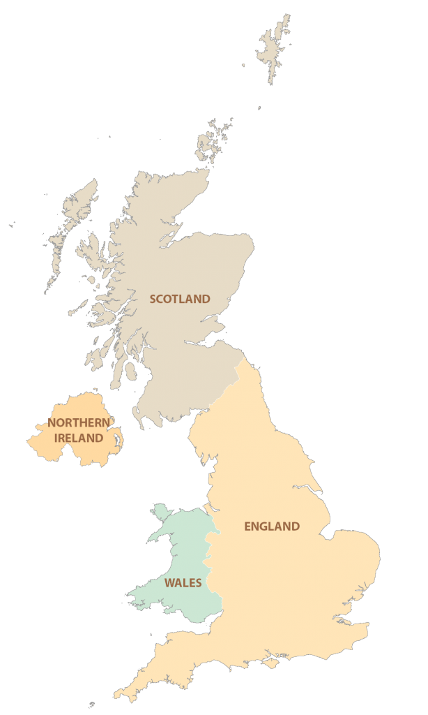
- England: England is the largest and most populous country within the United Kingdom. It has played a significant role in shaping the country’s history, politics, and culture. Its capital city, London, is not only the capital of England but also a global financial and cultural hub.
- Scotland: Situated to the north of England, Scotland has its own distinct legal system and education system. It boasts a stunning landscape with rugged mountains, historic castles, and picturesque lochs.
- Wales: To the west of England lies Wales, a country known for its rugged coastlines, mountainous landscapes, and rich history. The Welsh language has a strong presence here, and the country has preserved its unique traditions and cultural heritage.
- Northern Ireland: Located in the northeastern part of the island of Ireland, Northern Ireland shares a border with the Republic of Ireland to the south.
Capital City
London
Countries
England
Northern Ireland
Scotland
Wales
Major cities
Belfast
Birmingham
Bradford
Brighton
Bristol
Edinburgh
Glasgow
Leeds
Leicester
Manchester
Portsmouth
Sheffield
Southampton
Cities, towns and villages
Aberdeen
Ayr
Bath
Blackpool
Bournemouth
Cambridge
Cardiff
Carlisle
Chester
Coventry
Douglas
Dover
Dumfries
Dundee
Exetero
Fort William
Greenock
Inverness
Ipswich
Kingston upon Hull
Kirkwall
Lerwick
Lisburn
Liverpool
Londonderry
Luton
Middlesbrough
Muineachan
Newcastle
Norwich
Nottingham
Omagh
Oxford
Penzance
Perth
Peterborough
Plymouth
Reading
Scarborough
Southend-on-Sea
Stoke
Sunderland
Swansea
Wick
York
Lakes, rivers and water features
Atlantic Ocean
Bristol Channel
English Channel
Inner Seas
Irish Sea
North Sea
Islands
British Isles
Guernsey
Isle of Man
Orkney Island
Outer Hebrides
Shetland Island
Landforms and mountains
Cambrian Mts
Grampian Mts.
Lands End


Very helpful service guys, thank you for this resource.
Excellent source for maps of anywhere. Thank You