Innsbruck, the capital city of Tyrol, Austria, enjoys a privileged location in the Inntal Valley, surrounded by multiple mountain ranges of the Austrian Alps.
Set between the Karwendel’s Nordkette chain, an imposing wall of limestone, the Tux Alps, and the Kalkkögel mountains, Innsbruck is a playground for active travelers and hikers.
Innsbruck is also the gateway to the Mieming mountain chain and the Sellrain-Stubai mountains.
This guide to hiking in Innsbruck highlights our favorite day hikes, hut-to-hut hikes, and via ferrata climbs (special equipment needed) in the greater Innsbruck region.
You can also follow these Innsbruck hiking trail recommendations if you’re staying in Hall in Tirol, Absam, Wattens, Stans, Schwaz, Mutters, Axams, etc…

- When to Hike in Innsbruck: Late June – Late September/Late October, depending on snow conditions.
- Webcam: Innsbruck webcam
- Recommended Map: Innsbruck, hiking map 1:50,000 WK 241
- Getting to Trailheads: Use oebb.at, also synced with Google Maps, to find out how to reach trailheads with transit.
- Wild Camping: Wild camping is not allowed in Tyrol.
- Tip: Bring cash for toll roads and mountain huts.
- Where to Stay in Innsbruck: Motel One Innsbruck (budget-midrange), NALA individuellhotel (midrange), Altstadthotel Weisses Kreuz (luxury), or Weisses Rössl (luxury)
- Where to Stay in Hall in Tirol: kontor Boutiquehotel (luxury), or Parkhotel Hall in Tirol (luxury)
Innsbruck Hiking Map
Innsbruck Day Hikes
1. Goetheweg

The Goetheweg is a high-altitude, panoramic trail in the Karwendel Mountains.
This Innsbruck day hike starts at the Hafelekar mountain station (2269 m), accessible by cableway, and ends at the Pfeishütte mountain hut.
To get to the Hafelekar trailhead from the city center of Innsbruck, head to the Congress station (Google Maps) and take the Hungerburgbahn funicular to the Seegrubebahn valley station (Nordkette cableways valley station).
Next, take the Seegrubebahn gondola followed by the Hafelekar aerial cable car. These three cableways are collectively called the “Nordkettenbahnen” (Nordkette Cableways).
Purchase a Top of Innsbruck: Roundtrip Cable Car Ticket, which includes the funicular and cableways.
With sweeping views of the Inntal Valley and Innsbruck, the Goetheweg crosses the southern slopes of the Nordkette mountain chain to the Mühlkarscharte (2243 meters) saddle.
From the saddle, the path continues north below the Mandlspitze and twists up to the Mandlscharte (2314 meters). Much of this trail is protected with fixed cables. Along the way, there are excellent views of Zugspitze (2962 m), the highest mountain in Germany, and the Wetterstein Mountains.
The trail continues down to the charming Pfeishütte hut, where you can eat lunch. Make sure to bring cash.
Return along the same trail back to the Hafelekar mountain station.
Goetheweg Trail Stats
Starting Point | Innsbruck-Hungerburg valley station
Trailhead | Hafelekar mountain station
Distance | 10.7 km out-and-back
Time Needed | 4:45 – 5:00 hours
Elevation Gain/Loss | 614 meters
Difficulty | Moderately Difficult
2. Wolfsklamm Gorge

Wolfsklamm (Wolf’s Gorge), often lauded as the most arresting gorge in Tyrol, is located in the Karwendel Mountains.
The gateway to the gorge is Stans, a village in the Inntal Valley, 30 km east of Innsbruck. You can reach Stans by train, or by car.
Between May and October, hikers can enter this impressively narrow river gorge. A heavily-bolstered path, made up of stairs, railings, bridges, and fixed cables, clings to the gorge wall and steeply ascends the limestone chasm.
Like other gorge trails that require regular maintenance, there is a small entrance fee to enter (5 EUR for adults, 1.50 EUR for kids).
Due to safety reasons, it’s only possible to hike one-way up through Wolfsklamm. At the end of the trail, you can extend the hike to the Benedictine Monastery of St. Georgenberg, where there’s a restaurant. Or, you can descend immediately along the Way of the Cross via “Weng” trail.
If you love gorge hikes, also check out the Liechtenstein Gorge in Austria, Vintgar Gorge in Slovenia, Höllental Gorge in Germany, Partnach Gorge in Germany, and Cares Gorge in Spain.
Wolf’s Gorge Trail Stats
Trailhead | Parkplatz Wolfsklamm, Stans
Distance | 5.4 km circuit
Time Needed | 2:15 hours
Elevation Gain/Loss | 410 meters
Difficulty | Moderate
Entrance Fee | 5 EUR for Adults, 1.50 EUR for Kids (ages 6-14)
Learn More: Wolfsklamm Hiking Guide
3. Zirbenweg

The Zirbenweg (aka Stone Pine Trail) is a panoramic path in the Tux Alps, the range that borders the Inntal to the south, opposite the Karwendel mountains.
It’s called the Stone Pine Trail because it leads through one of the oldest and largest stone pine stands in Europe.
The Stone Pine Trail connects the Patscherkofelbahn mountain station with the Glungezerbahn mountain station, running at a high altitude (2000 meters) with very minimal elevation gain/loss.
This hike is appealing, because it’s a scenic trail which requires very little exertion.
Stone Pine Trail Stats
Trailhead | Patscherkofelbahn Mountain Station
Ending Point | Glungezerbahn Mountain Station
Distance | 7.7 km point-to-point
Time Needed | 2:30 hours
Elevation Gain | 198 meters
Elevation Loss | 106 meters
Difficulty | Easy
Learn More: Stone Pine Trail Hiking Guide
4. Nockspitze

Nockspitze (aka Saile) is a panoramic peak in the Kalkkögel mountains that stands southwest of Innsbruck. The summit rewards hikers with far-reaching views of the Inntal Valley, Innsbruck, the Karwendel Mountains, and the Stubai Alps.
To start the hike, drive, or take a bus (with a transfer in Axams) to the Axamer Lizum ski area.
If you’re hiking this trail between Thursday and Sunday in high season, you can trim off some elevation by taking the Birgitzköpfl Chairlift (that’s what we did). This chairlift is free for Innsbruck Welcome Card holders.
From the Birgitzköpfl Chairlift, the trail crosses slopes and ascends across a series of summits to reach the summit of Nockspitze.
Nockspitze – Saile Trail Stats
Trailhead | Axamer Lizum / Birgitzköpfl Chairlift mountain station
Distance | 6.4 km circuit with chairlift ascent
Time Needed | 4 hours
Elevation Gain | 418 meters
Elevation Loss | 905 meters
Difficulty | Moderately Difficult
Learn More: Nockspitze Hiking Guide
Via Ferrata Hikes around Innsbruck
(Special Equipment Needed)
5. Hundskopf Peak and Felix-Kuen-Steig
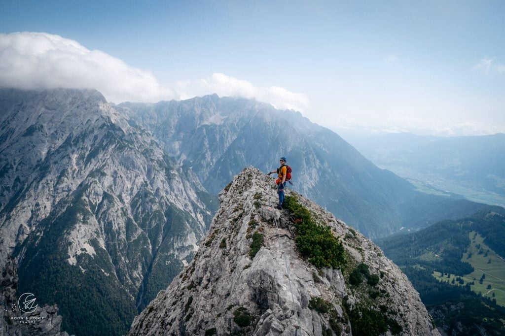
Hundskopf (2243 m) is the easternmost rocky summit in the Gleirsch-Halltal Chain of the Karwendel Mountains.
This Innsbruck hiking trail starts at Hinterhornalm (1522 m), which is only accessible by car via a toll road (fees apply, bring cash).
To reach the Hundskopf summit, hikers have two options. They can either ascend the 15-minute Felix-Kuen-Steig (Grade A/B), a short and easy via ferrata (Klettersteig in German). Or, they can ascend the eastern ridge to the summit, which is an airy, partially-secured path.
Ideally, hikers ascend the Felix-Kuen-Steig to Hundskopf and then descend the eastern ridge in one circuit.
It takes 2 hours to reach the base of the Felix-Kuen-Steig. It’s a tough ascent, only suitable for experienced, acclimated hikers who have no fear of heights.
Before completing the hike, we suggest detouring to the Walderalm mountain pasture for delicious Tyrolean Knödel.
Hundskopf Trail Stats
Trailhead | Hinterhornalm, Gnadenwald
Distance | 6.9 km lollipop circuit
Time Needed | 4 hours
Elevation Gain/Loss | 764 meters
Via Ferrata Difficulty | Easy, Grade A/B
Hike Difficulty | Difficult
Learn More: Hundskopf Hiking Guide
Hut to Hut Hiking Trails around Innsbruck
6. Karwendel High Trail

The 6-stage Karwendel High Trail (Karwendel Höhenweg) is a hut-to-hut hike in the Karwendel Mountains of Tyrol, which starts in Scharnitz and ends in Seefeld in Tirol.
You can reach the Scharnitz trailhead by train from either Innsbruck, or Seefeld in Tirol, in Austria, or from Munich in Germany.
This 63-km U-shaped hiking trail in Tirol weaves through gorgeous high alpine environments, gifting hikers sweeping views of the Stubai and Zillertal Alps as well as the Inntal, Halltal, and Sammertal Valleys.
In 6 days, hikers will walk along the Isar river, summit Speckkarspitze and Kleine Stempeljochspitze peaks (optional), follow a narrow balcony trail overlooking Innsbruck, and conquer the challenging ascents and descents to the Stempeljoch and Frau Hitt mountain saddles.
Beyond the stirring views of the limestone mountains, you’ll experience some of Austria’s most welcoming and convivial mountain huts.
Each hut along this route is staffed by an attentive and hospitable team. And, the food is sensational as well.
Karwendel High Trail Trail Stats
Starting Point | Scharnitz, Tyrol
Ending Point | Seefeld, Tyrol
Distance | 63 km u-shaped circuit
Time Needed | 6 Days
Difficulty | Difficult
Learn More: Karwendel High Trail
Where to Stay around Innsbruck
Innsbruck City Center

Budget-Midrange | Motel One Innsbruck is located near the Innsbruck Train Station, a mere 10-minute walk into the Innenstadt (Inner City of Innsbruck). This modern 3-star hotel offers snug rooms with views overlooking the city and mountains. Don’t miss the top floor bar. Perks: luggage storage and 24/7 reception. Breakfast and underground parking are both available for an extra charge.
Midrange | NALA individuellhotel is a quirky hotel with uniquely-designed rooms, a sun terrace, fitness room, breakfast (extra fee), and nearby parking (extra fee).
Midrange-Luxury | Faktorei is a boutique hotel housed in a 15th century town house with 12 sun-drenched minimalist rooms, a garden, terrace, and bar. Private garage parking is available, but must be reserved in advance (extra fee). Breakfast is served in the hotel’s adjacent café (extra fee).
Top Choice – Luxury | Altstadthotel Weisses Kreuz is a contemporary hotel with an atmospheric bar in Innsbruck’s pedestrian zone. Stay here for the delicious breakfast, stylish design, professional staff, and location. No on-site parking.
Top Choice – Luxury | Set in a historic building in the center of Innsbruck, the exceptional Weisses Rössl is a boutique hotel with a 600-year-old Tyrolean restaurant. Expect a delicious breakfast. Paid public parking is located nearby.
More Innsbruck Accommodations: Montagu Hostel (budget), Hotel Innsbruck (luxury), or Hotel Zach (luxury)
Look for accommodation in Innsbruck.
Hall in Tirol
Hall in Tirol is a town in the Inn Valley, just east of Innsbruck. Its historic center has been beautifully restored, making it a delight to explore on foot. Hall rose to prominence in the 13th century, because of the salt industry.
It was actually the most important commercial center in North Tirol. This is a great base for exploring the Karwendel Mountains and Innsbruck’s surroundings.
Top-Choice Luxury | Hotel Kontor is a boutique hotel in Hall in Tirol with airy, minimalist rooms featuring hardwood floors, billowy linen, and tea and coffee makers. Breakfast is included. On-site parking is available.
Luxury | Parkhotel Hall in Tirol is a modern, dog-friendly hotel with soundproof rooms, an on-site restaurant, and a 580 m2 spa area, walking distance to the historic Altstadt (Old Town). Parking is available (extra charge). A rich breakfast is included.
Look for accommodation in Hall in Tirol.
More Hikes around Innsbruck
Lake Achensee:
- Lake Achensee Hikes
- Gramai Alm to Hahnkampl Circuit Trail
- Seekarspitze and Seebergspitze Ridge Trail
- Hochiss Peak Hike
- Bärenkopf Peak Hike
Seefeld in Tirol:
Ehrwald:

Austria Trip Planning Essentials
Use our Austria Travel Guide and Austria blog archive to plan a unique and memorable trip to Austria.
When to Visit Austria
Summer and early Fall are our favorite seasons in Austria.
Getting around Austria
Austria has an excellent public transit system. We’ve used it extensively to travel throughout the country. We highly recommend using transit if you’re visiting cities (Vienna, Salzburg, Innsbruck, Graz, etc…), and/or doing hut-to-hut hikes.
Some areas like Mayrhofen, Schladming and Lech am Arlberg have wonderful seasonal transit systems in place (e.g. summer hiking buses). However, if you’re not visiting during the high season, bus frequencies are significantly reduced and it’s far easier to get around with your own vehicle.
If you’re planning on visiting multiple destinations across Austria, we recommend renting a car.
Use these road trip itineraries for trip planning inspiration:
- 2 Week Austria Road Trip – starting in Vienna
- 1 Week Austria Road Trip – starting in Salzburg, or Munich
- 10-Day Bavarian Alps & Tyrolean Alps Road Trip – starting in Munich
Car Rental
We recommend using the Discovercars.com car rental reservation platform to search for and book car rentals. This easy-to-use booking platform compares car rental deals from 500+ trusted providers, so that you can choose the best option for your trip.
If you’re driving into Austria from a neighboring country, don’t forget to purchase a vignette at/near the border.
Hiking in Austria
Where to Hike in Austria
Read Austrian Alps Hiking Destinations for an overview of where to hike in Austria, with tips on specific trails and where to stay. Also check out Best Day Hikes in Austria and these region-specific hiking guides:
- Salzburg Hiking Guide
- Filzmoos, Salzburg Hiking Guide
- Schladming, Styria Hiking Guide
- Lech am Arlberg, Vorarlberg Hiking Guide
- Vorarlberg Hiking Guide
- Vienna Mountains Hiking Guide
Hut to Hut Hiking in Austria
Austria is a premier hut-to-hut and long-distance hiking destination. The quality of the mountain huts are superb. We particularly love the high-alpine trails, which are called Höhenwege in German. We’ve summarized our favorite multi-day hikes in Trekking Austria. If you’re new to hut hiking, read this in-depth guide to Hut to Hut Hiking in Austria.
Hiking Essentials
- Day Pack: Osprey Tempest 30 Women’s Backpack / Osprey Talon 33 Men’s Backpack
- Grade B/C high-cut hiking boots: Meindl Schuhe Island Lady (Kati’s Boots), Women’s Hanwag Tatra II GTX (Sabrina’s Boots), Men’s Hanwag Tatra II GTX (men’s equivalent)
- CAT 4 Sunglasses: Julbo Shield Mountain Sunglasses
- Hiking Poles: Black Diamond Trail Trekking Poles
- Backpack Camera Clip: Peak Design Camera Clip
What to See & Do in Austria
- Visit a gorge like the Liechtenstein Gorge in Salzburg.
- Bathe in the thermal pools of an Austrian Therme like Aqua Dome in Tirol.
- Stay in a thermal spa hotel like Rogner Bad Blumau in Styria, EurothermenResort Bad Ischl in Upper Austria, or the Aqua Dome Hotel in Tirol.
- Hike to a mountain lake like Lake Tappenkarsee in Salzburg or Lake Drachensee in Tirol.
- Go Wine Tasting in South Styria.
- Marvel at the culture, music, and architecture of Vienna.
- Eat heartwarming mountain food in an Almhütte at Grosser Ahornboden in Tirol or Ursprungalm in Styria.
- Drive the Grossglockner High Alpine Road in Hohe Tauern National Park.
- Visit the castles, monasteries, and wine taverns of the Wachau Valley, a UNESCO World Heritage Site.
Austrian Hotels
- Best Hotels in the Austrian Alps
- Best Hotels in Lech am Arlberg, Vorarlberg
- Wellness Hotel Theresa, Zillertal, Tirol
- Hotel Eder in Maria Alm, Salzburg
Discover More of Tyrol and Beyond
Tyrol:
Bavaria:
