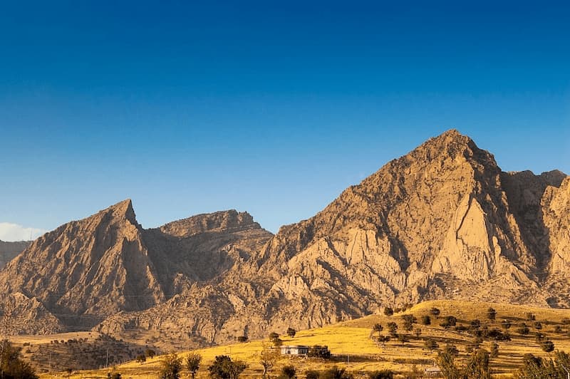
The gargantuan Zagros Mountain range, which rises and falls like the ridged back of a giant dinosaur, sleeps in the west of the country. The Mountain range extends from Turkey and the Armenian highlands in the northwest to the Persian Gulf and the Strait of Hormuz in the south. Several of its peaks are higher than 4000 meters, but the highest is Qash-Mastan in Mount Dena with a peak of 4459 meters.
Where does the name Zagros come from?
One of the ancient names of the Zagros mountain range is Kor or Kur, which in Sumerian mythology refers to a mountain or mountains. Kor is also another name for the Akkadian Empire, which dates back to three thousand years ago. Another Ancient Avestan name for the Zagros mountains is the Avestan Esproch or Esproz. Some even consider the name of Zagros to be Avestan. In the Avestan language, Zager Za-G’R’ means big mountain. But there is another opinion that this word is taken from the name of Indo-European immigrants living in this area known as Sagartians. The old name of this mountain range in the Persian language was “Pataq”, which is also the name of a famous mountain range in Kermanshah. The word “Zagros” entered the Persian language at the end of the Qajar period through the translation of the works of European authors (and sometimes from the Greek language). It acquired the Greek suffix ‘os,’ and then it was also placed on the map of Iran. Hassan Pirnia is the first person who mention the word Zagros in his book “History of Iran from the Beginning to the Demise of the Sasanians”. He emphasized that the Europeans call it Zagros. However, in the historical sources, the word Zagros is not only applied to the mountain range; Mohammad Qazvini writes in his book: “Zagros is the Greek name of the western mountains of Iran, especially the Bakhtiari region in the west of Iran.”

In the Grand Larousse encyclopédique, Zagros is briefly mentioned as the name of a valley that is rich in oil. In the Greek-German dictionary published in Leipzig in 1886, the word Zagrio or Zagros is cited as “a mountain in the Median era” by quoting the writings of Strabo and Polybius. In the geographic dictionary Lexique géographique, under the word and title “Zagros” (Zagros) it is stated: “It is a mountain range in Asia that stretches from the northwest to the southeast.” French archaeologist Romain Gershman considered Zagros to be a tribal name in his book and writes: “The general movement of Iranian tribes had not yet ended when a third important Iranian tribe named “Zikirtu” or “Sagarti” went to the eastern regions and settled.” He writes: “Other tribes are: Dayans, Amardi, Dropikeas, and Sagarti” Diakonov also writes in his book on the history of the Medes in the description of the Assyrian attack on Parsova and based on the inscriptions read: “As stated in the text, the last The point of the campaign was Zakroti” According to the mentioned materials, the origin of the word Zagros is from the Avestan language, and the Greeks changed this word to Greek by adding ‘S’ to the end of it. In addition to the name of the mountain, the word Zagros has also been the name of a fort, tribe, tribe, and place.
The Geographic Placement of the Zagros Mountain Range
The Zagros mountain range is about 990 miles (1600 km) long and more than 240 miles (240 km) wide. This region, which is mostly in Iran, forms the western border of the Iranian plateau. Its ranges extend to the neighboring countries in the north and west, starting from Lake Van in Turkey and extending to the south and southeast of Iran.
Check out our Mount Damavand Tours to visit the highest peak of another famous mountain range in Iran; Alborz.
Locating the Zagros Mountain Range on the Map
As shown in the map below, the purple parts are the Zagros mountain forest steppe.

How Were the Zagros Mountains Formed?
The formation of the Zagros mountain range belt resulted from a complex and lengthy orogeny that started in the Paleozoic era and continues until today. It was spread between the Arabian and Eurasian plates. As the Arabian plate commenced its northward movement and the Neo-Tethys Ocean subsided beneath the Eurasian plate, certain rifts within the oceanic crust, termed ophiolites, were thrust atop the continental shelf sedimentary sequence. Further convergence caused tension in the lithosphere and caused extensive folding and thrusting in these shelf sediments. The compressive stresses created several large-scale, northeast-dipping thrust faults that now separate the Zagros Mountains into five parallel tectonic belts. In addition, numerous northwest-southeast parallel folds have been created, creating spectacular angular anticlines and mountain peaks that are between 3,000 and 3,650 meters above sea level. Still, the annual movement of this plate causes elevation. It is at the top of these areas. The sedimentation of the continental plateau led to the formation of oil reserves in these regions, which now constitute significant global oil reservoirs.
Divisions and Subranges Within the Zagros Mountains
The Zagros mountain range is divided into higher (or elevated) Zagros and folded Zagros. The higher Zagros is the northern part of Zagros, where the highest peaks of the mountain range, including Oshtorankuh, Zardkooh, and Dana, are located, which are covered with snow most of the year. In terms of width, this region is the smaller part (about 80 kilometers), and in terms of height, it is the main part of Zagros and folded Zagros, which includes the western and southern parts of Zagros, and it is the main region in terms of land size (it is about 250 kilometers wide). In another division, Zagros includes North, Middle, and South Zagros, where the iron difference is more in the northern part. The south is evident in terms of the difference in folds. Central Zagros is mainly mountainous and is located at an altitude of 830 to 4416 meters above sea level. The average height of the range is 2332 meters. 34 percent of the range has an altitude of 2,100-2,400 meters, and less than 1 percent of it has an altitude of less than 1,000 meters. This area is the residence and livelihood of about 10% of the country’s population. With over fifty percent of the country’s nomadic population relying on the Zagros region, it holds significant importance as one of the primary centers for nomadic life in the country.
Locating the Zagros Mountains: Which Provinces Are They In?
This legendary and huge mountain range covers many provinces, including West Azerbaijan, Lorestan, Hamedan, Central, Isfahan, Fars, Kurdistan, Kermanshah, Ilam, Kohgiluyeh and Boyer-Ahmad, Chaharmahal and Bakhtiari, Khuzestan, Kerman, Bushehr, and Hormozgan. They go all the way from north to south of the country. Iran Trekking Tours will provide you with information about trekking in these ranges.
A Closer Look at the Flora of the Zagros Range
The forests of the Zagros mountain range date back to about 5500 years ago. The dominant tree of these forests is the oak. The forests of Zagros are generally divided into two parts: North Zagros and South Zagros. Vegetation in the western areas includes cold climate plants and tropical plants in the eastern areas. Most of the vegetation of the Zagros forest habitat is made up of oak trees. At heights higher than the forest border (about 2,300 meters), you can see dense grasslands and bushes. Dena Protected Area is an example of the forest habitat of Zagros. Zagros forests are spread over 11 provinces of the country with an area of 6 million hectares, constituting 40% of Iran’s forests, and about 70% of Zagros forest species include oaks. The climate of the region is the semi-arid Mediterranean with cold winters. Other tree species of these forests can be named Fara, Kikam, Bene, Sparrow’s Tongue, Wild Pear, Velik, and Purple. In general, it can be said that oak communities are present at an altitude of 650 to 2400 meters above sea level. Above this altitude, juniper communities appear; below that, almond-almond communities appear. The dominant form of forestry is branched forests, and this indicates the destruction caused by the long-term presence of human societies.
Many different types of wild spices and grapevines can be found in the Zagros Mountains. As a region where grapes grow in the wild, it may be unsurprising to know that several sites in the northern Zagros house the oldest site for viniculture. The Oldest of these is the Hajji Firuz Tape which provides evidence for winemaking in the region goes back to at least 7000 years ago. This Evidence came from six nine-liter wine Jars that archaeologists date to 5000 to 5400 BCE.

Discovering the Wildlife of the Zagros Mountains
The Zagros mountain range has long supported a variety of animals, including brown bears, Asian black bears, eagles, wild goats, sheep, wolves, leopards, and other wild cats. Five species of lizards are native to the Zagros range and the adjacent mountains of Anatolia, the endangered Iranian deer, once thought to be extinct, has recently been rediscovered on the western slopes of the mountain range, the small spotted eagle and the golden eagle in the forested hills and The mountainous regions of the north and west of Iran reproduce. Distinguished by its unique curved horns, it lives on high cliffs and in mountainous areas. This species is endangered, with major threats from hunting and habitat loss due to grazing and logging activities. These trends are also likely to threaten the leopard, which prefers highlands, forests, and wooded areas where it can feed on sheep, goats, and other prey. Regions of the Blandford’s fox, one of the rarest foxes in the world, occupy the mountainous regions of Kerman and Fars. Other species that have been recorded in the southwestern part of this region include jackal, fox, the forest cat, and in semi-arid steppe areas, several types of partridge and black vulture have been recorded.
Deserts are another form of the iconic natural landscape in Iran, so make sure to check out our Iran Desert Tours for more information.