Raised-Relief Maps of Europe
This post may contain affiliate links. As an Amazon Associate, we earn from qualifying purchases.
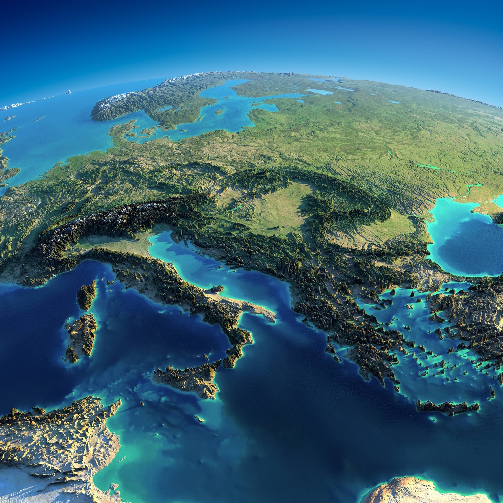
In terms of shape, Europe is an assemblage of connected peninsulas and nearby islands. There are two largest peninsulas in Europe: mainland Europe and Scandinavia to the north, separated by the Baltic Sea. Three smaller peninsulas – Italy, Iberia, and the Balkans – emerge from the southern edge of the mainland.
As mainland Europe moves eastward, its borders with Asia are marked by the Ural Mountains, the Ural River, the Caspian Sea, and the Caucasus Mountains.
Land relief in Europe shows significant variation within relatively small areas. Alps, Pyrenees, and Carpathians dominate the southern regions, while wide, low northern plains, extending eastward, descend from the high Alps, Pyrenees, and Carpathians.
Along the northwestern seaboard, there is an arc of uplands that begins in southwestern Ireland, continues through western and northern Great Britain, and ends in Norway, with its mountainous spine and fjords.
Central and Eastern Europe
South-western Europe

Here is the list of the most important peculiarities of Europe’s relief:
- Mountain Ranges: Europe is home to several prominent mountain ranges. The Alps, located in Central Europe, stretch across eight countries and include iconic peaks such as Mont Blanc. The Pyrenees separate France and Spain, while the Carpathian Mountains extend through Eastern Europe. Other notable ranges include the Scottish Highlands, the Apennines in Italy, and the Scandinavian Mountains in the north.
- Central Uplands: The Central Uplands form a vast region in the heart of Europe. It consists of plateaus, hills, and low mountains, such as the Massif Central in France, the Bohemian Massif in the Czech Republic, and the Ardennes in Belgium. These uplands offer picturesque landscapes and are often characterized by dense forests and agricultural areas.
- Northern European Plain: Stretching from France to Russia, the Northern European Plain is a vast low-lying area that covers parts of several countries. It is one of the flattest and most extensive plains in Europe, making it ideal for agriculture. This plain includes fertile farmlands, river valleys, and coastal areas.
- Peninsulas: Europe is known for its numerous peninsulas. The Iberian Peninsula, which includes Spain and Portugal, juts out into the Atlantic Ocean. The Scandinavian Peninsula extends northward, while the Italian Peninsula extends into the Mediterranean Sea. The Balkan Peninsula, located in southeastern Europe, is characterized by rugged mountains and a jagged coastline.
- River Systems: Europe is crisscrossed by several major rivers that have played a crucial role in its history and development. The Danube, Europe’s second-longest river, flows through multiple countries and is an important transportation route. The Rhine, Rhône, Seine, Thames, and many others are significant waterways that have shaped the landscapes and provided trade routes throughout the continent.
- Volcanoes: While not as well-known for volcanic activity as other regions, Europe has several notable volcanic areas. Iceland is a prime example, with its geothermal activity, hot springs, and volcanoes such as Eyjafjallajökull and Hekla. Italy is home to the active volcanoes of Mount Etna, Stromboli, and Vesuvius, the latter famously responsible for the destruction of Pompeii in 79 AD.
- Coastal Features: Europe boasts diverse coastlines with varying features. The fjords of Norway offer breathtaking views with their steep cliffs and deep, narrow inlets. The rugged coasts of Ireland and Scotland are characterized by sea cliffs and rocky shores. The Mediterranean coastline is renowned for its sandy beaches and picturesque coastal towns.
- Islands: Europe is surrounded by numerous islands of different sizes. The British Isles, comprising Great Britain and Ireland, are the largest islands in the region. The Greek Islands, including Crete, Rhodes, and Santorini, are famous for their stunning landscapes and historical sites. The Balearic Islands, located in the western Mediterranean, are a popular tourist destination.
Totally awesome, the first map. Comparing it to an atlas map, I could place many central European countries in terms of their landscape. I have a much better understanding of European geography now. I would love to see more maps like this. Where did they come from?
i am a map freak. this is the best of all, i ve ever seen. well done!
Hey there. Central and Eastern Europe Map is so awesome. Could i get a high res version of that map somehow?