
Map projections allow us to convert from sphere to planar (flat) representation. Geographic coordinate systems allow for the measurements of distances and to determine direction. Except for the Geographic Grid all coordinate systems are based on some form of map projection.
What is a Geographic Coordinate System?
A Geographic Coordinate System is a reference framework used to define the location of features on the surface of the Earth. It is a system of latitude and longitude coordinates that defines a three-dimensional position of a point on the Earth’s surface.
These coordinates are based on an ellipsoid that approximates the shape of the Earth, and they allow us to measure distances and angles between different points on the Earth.
Two main types of georeferenced data coordinate systems
There are two main types of coordinate systems for georeferenced data:
Free weekly newsletter
Fill out your e-mail address to receive our newsletter!
Geographic Coordinate Systems (GCS) based on latitude and longitude
A Geographic Coordinate System is a 3D reference system that uses latitude and longitude to define the location of a point on the Earth’s surface.
The latitude and longitude coordinates are measured in degrees, minutes, and seconds, with the equator as the reference line for latitude and the Prime Meridian (Greenwich Meridian) as the reference line for longitude.
The most commonly used geographic coordinate system is the World Geodetic System 1984 (WGS 84). It is used by GPS receivers and is the standard for most GIS applications.
Projected Coordinate Systems (PCS) based on a map projection
A Projected Coordinate System is a 2D reference system that uses Cartesian coordinates (X,Y) to represent the location of a point on a two-dimensional surface. PCS are created by projecting the 3D GCS onto a two-dimensional surface.
There are many different types of projected coordinate systems, each with its own map projection method, and each is designed for a specific area of the Earth’s surface.
Examples of projected coordinate systems include Universal Transverse Mercator (UTM), State Plane Coordinate System (SPCS), and Lambert Conformal Conic.
Geographic Coordinate System Units
The units of measurement for degrees of longitude (x-coordinates) and degrees of latitude (y-coordinates) in geographic coordinate systems, often known as GCS, are commonly decimal degrees.
Geographic coordinates are expressed as a position that is either north or south of the Equator and east or west of the Prime Meridian.
Latitude
The Equator is the line of latitude that cuts across the center of the Earth and marks zero degrees of latitude. Latitude lines are also known as parallels that are found on the Y-axis.
Geographic locations that are north of the Equator (0° latitude) have positive latitude (or Y-values) coordinates. Geographic locations that are south of the Equator have negative latitude values.
Longitude
The Prime Meridian, which passes through the Royal Observatory in Greenwich, England in the United Kingdom, is the line of longitude that is at zero degrees and runs from the North Pole to the South Pole. Longitude lines are found along the X-axis.
Geographic locations that are east of the Prime Meridian (0° longitude) have positive longitude (or X-values) coordinates. Geographic locations that are west of the Prime Meridian have negative longitude values.

Universal transverse Mercator (UTM)
Universal transverse Mercator (UTM) is a geographic coordinate system and the most prevalent plane grid system used. UTM divides the earth into 84˚ north latitude to 80˚ south and is numbered into 60 vertical zones (each 6˚ latitude wide).
All measurements are positive. There are two starting points (all measurements in meters north and east); one at the equator and another at 80˚ south (1000,000,000 meters south of the equator).
UTM is used for remote sensing (satellite and aerial imagery analysis) because it allows precise measurement using the metric system. UTM uses transverse Mercator projection (conformal). This coordinate system is used by the US federal government for their data. The Equator is designated as the origin for Northing (y) and 500,000 meters is the false easting (x).
State Plane Coordinate System (SPCS)
The state plane coordinate system uses a unique set of coordinates for each of the 50 states, using either a transverse Mercator or Lambert’s conformal conic project tied to a national geodetic framework.
Each SPCS zone has its own projection and coordinate grid. SPCS uses feet as the measurement. This coordinate system is highly accurate (four times as accurate as UTM). For more: state plane coordinate system.

Datums
Grid systems rely on accurate measurements of the earth. The starting point for such a measurement is called the datum and is based on ellipsoidal representation.
In other words, the component of the geographic coordinate system known as the datum defines which model (spheroid) will be used to represent the Earth’s surface and its position on the Earth’s surface.
There are different datums that were developed for use in different parts of the world.
- First NA datum (1866) – Flatness ratio of 1/294.9787 1-b(polar axis)/a(equatorial axis)
- NAD 27 used the same ratio
- NAD 83 based on estimates of distance to center of the earth
- Now the standard (GRS80)
Converting From One Coordinate System to Another
Datum transformations are calculations that convert one coordinates system to another coordinate systems.
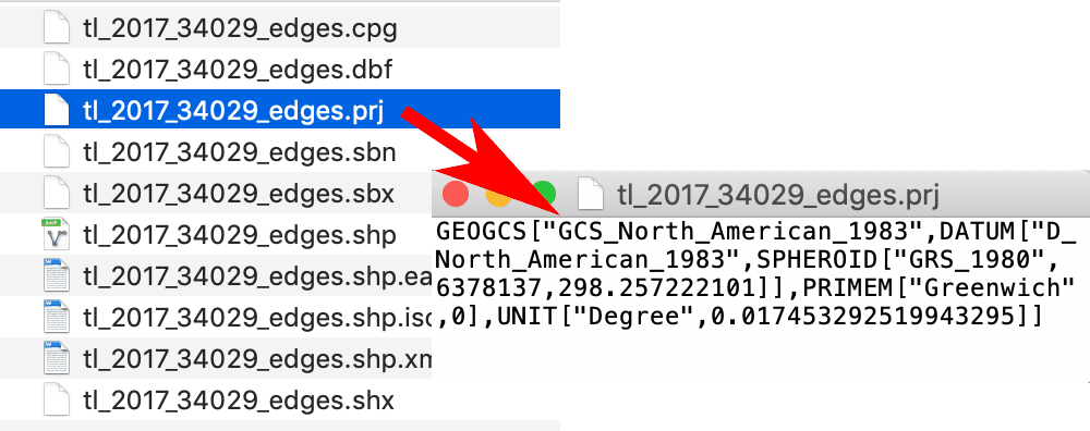
Many GIS programs can convert map coordinate systems “on the fly” if the GIS data has what is known as a map projection file attached. The map projection file contains information about the coordinate system, the map projection, and other information about the geographic extent of the geospatial data file.
References
Aber, J. S., Marzolff, I., & Ries, J. B. (2010). Chapter 11—Image Processing and Analysis. In J. S. Aber, I. Marzolff, & J. B. Ries (Eds.), Small-Format Aerial Photography (pp. 159–181). Elsevier. https://doi.org/10.1016/B978-0-444-53260-2.10011-0