A Tropical Cyclone Wind Signal (TCWS) is a plain text warning to particular land area that may experience winds of at least strong breeze in strength on the Beaufort Scale (i.e., 39 km/h, 22 kt or higher) within at most 36 hours from the time the signal is put into effect during the passage of a tropical cyclone. A particular wind signal has an equivalent expected wind threat, length of time (in hours) before onset of expected wind threat, and potential impacts to the locality. The current TCWS system uses five (5) levels of wind signals that are numbered from 1 to 5, with a higher signal number associated with higher general wind strength and shorter warning lead time.
The following must be taken into consideration when using the TCWS system:
- The TCWS is meant to warn the public of the threat of general wind strength associated with a tropical cyclone. Owing to the presence of natural and artificial obstructions such as local topography or nearby buildings, winds in a particular area (local winds) may be substantially stronger from the general wind strength over the provincial or sub-provincial locality implied by the wind signal. For instance, local winds are generally stronger over offshore water and on high ground (i.e., on mountainous areas) and are weaker in areas that are sheltered from the prevailing wind direction.
- A wind signal is usually hoisted at the level of a province, independent component city, or highly urbanized city (except for Metro Manila who is collectively placed under a single wind signal level). However, if the meteorological situation requires, a wind signal can be issued at the level of a city or municipality.
- The extent and timing of hoisting of wind signals are based on the intensity, extent of strong winds or higher, and the forecast direction and speed of movement of the tropical cyclone at the time of issuance of a bulletin. As such, any change in intensity, extent of strong winds or higher, or movement of the tropical cyclone also determines the change in the wind signal over a given locality.
- Although the TCWS is a tiered system, the escalation or de-escalation of wind signals allows the skipping of wind signal levels. For instance, Wind Signal #1 on a particular locality can be upgraded directly to Wind Signal #3 without passing Wind Signal #2. However, this is only observed if the issuance of an intermediate tropical cyclone bulletin is not sufficient to rapidly change the level of the hoisted wind signal over a locality.
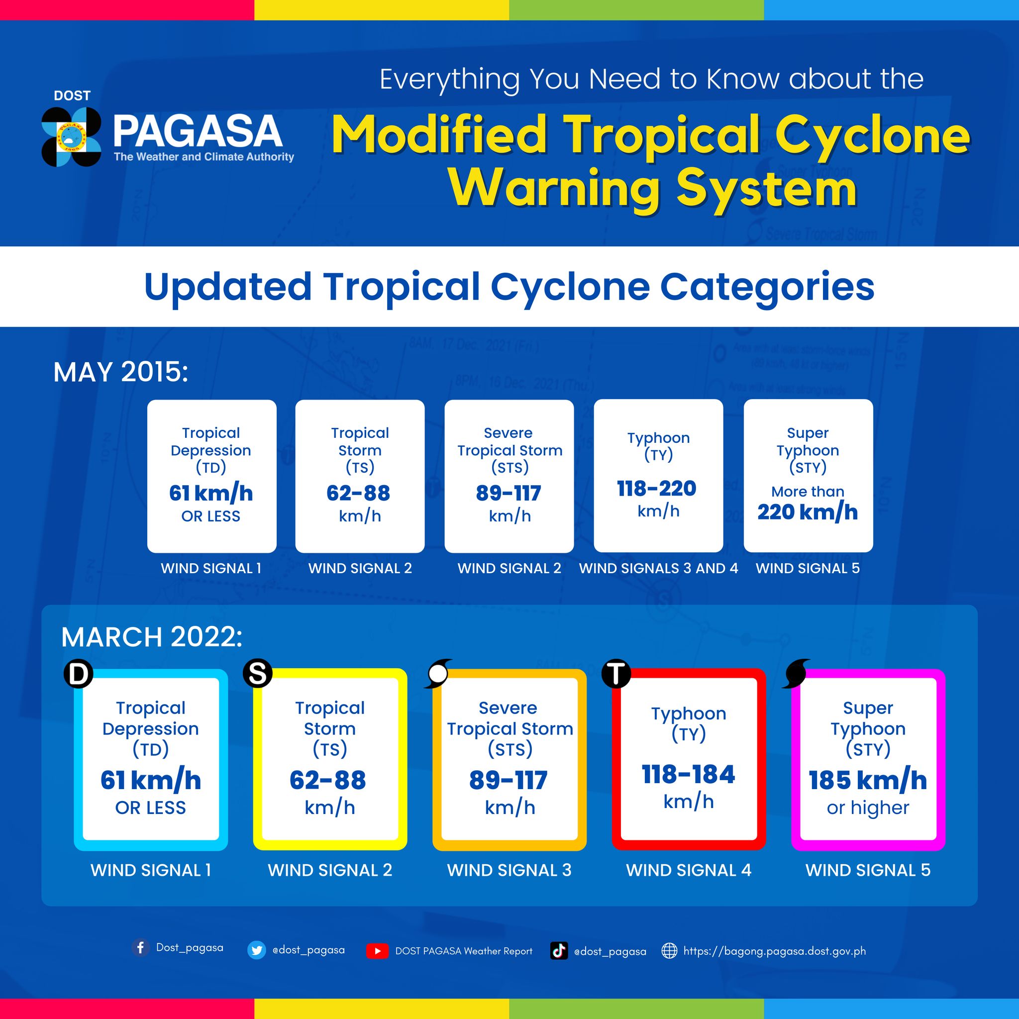
The current TCWS system has been in use since 23 March 2022 based on the adoption of best practices from other tropical cyclone warning centers and regionally-accepted operational standards, developments in objective forecast guidance, operational experiences and challenges encountered by typhoon forecasters, and feedback from end-users and stakeholders.
Tropical Cyclone Wind Signal
Tropical Cyclone Wind Signal #1
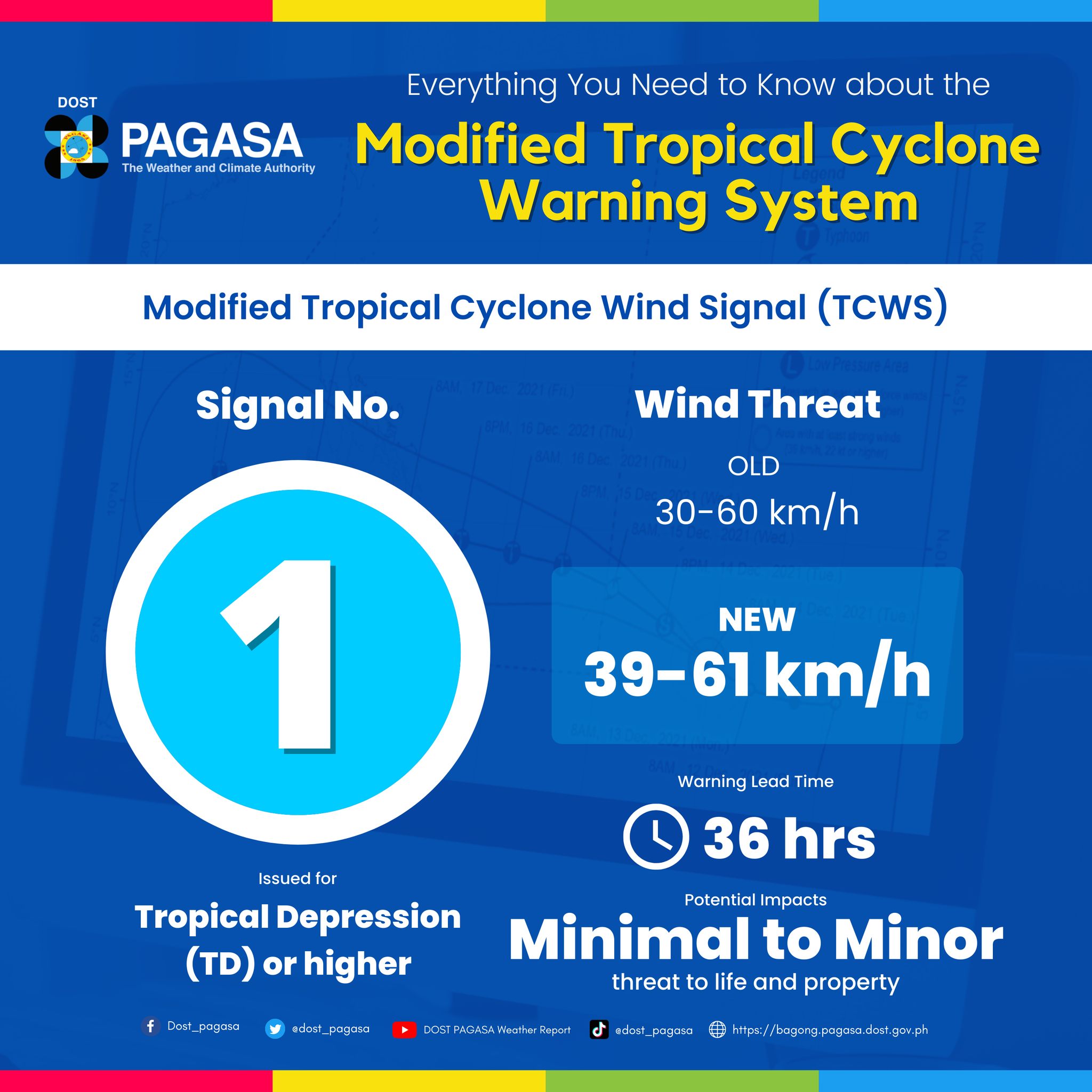
WIND THREAT: 39-61 km/h (22-33 kt, 10.8-17.1 m/s)
WARNING LEAD TIME: 36 hours
POTENTIAL IMPACTS:
- House of poor construction (e.g., wood frame, bamboo, makeshift), old dilapidated structures, and other structures made of light materials will suffer minimal to minor damage.
- Some banana and similar plants are tilted, while twigs of small trees may sway with the wind. Rice crops, especially those in flowering and ripening stages, may suffer some damage.
- Minimal disruption to public transportation.
Tropical Cyclone Wind Signal #2
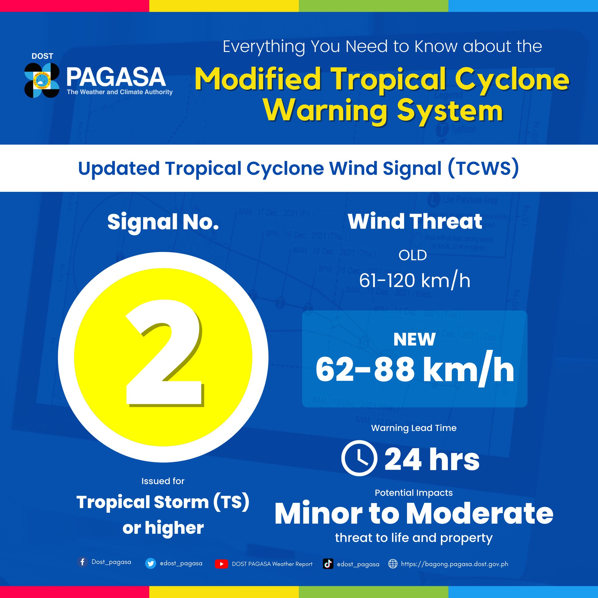
WIND THREAT: 62-88 km/h (34-47 kt, 17.2-24.4 m/s)
WARNING LEAD TIME: 24 hours
POTENTIAL IMPACTS:
- Minor to moderate damage may occur to makeshift or old dilapidated structures, and other structures made of light materials. Houses of poor and average construction (e.g., unreinforced CHB/masonry, mixed timber-CHB) may receive minor roof damage.
- Unsecures, exposed lightweight items may become projectiles which may cause additional damage.
- Some electrical wires may be blown down, resulting in local power outages.
- Minor to moderate disruption to public transportation.
- Most banana and similar plants are tilted, with some stooped or downed. Some small trees blow over, with twigs and branches of frail trees broken. Considerable damage is likely to rice and other similar crops, especially those in flowering and ripening stages.
Tropical Cyclone Wind Signal #3
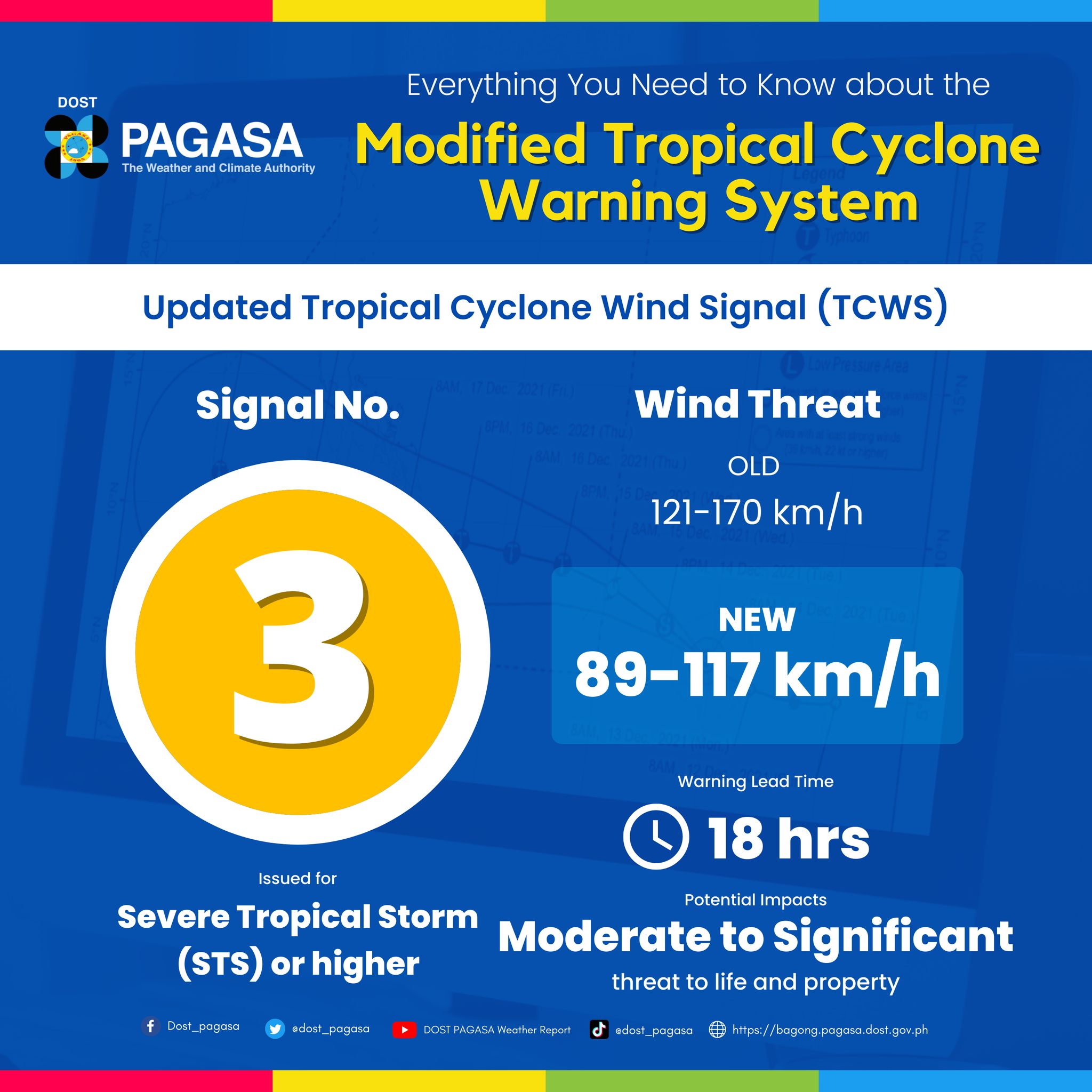
WIND THREAT: 89-117 km/h (48-63 kt, 24.5-32.6 m/s)
WARNING LEAD TIME: 18 hours
POTENTIAL IMPACTS:
- Makeshift or old, dilapidated structures, and other structures made of light materials may suffer substantial damage. Houses of poor or average construction will have considerate roof damage, some blown-out windows, and/or partial wall damage. Well-constructed houses (e.g., reinforced/pre-cast CHB, reinforced concrete moment frame) may suffer minimal to minor roof damage.
- Warehouses and other buildings in industrial parks may suffer minor to moderate damage.
- Unsecured, exposed outdoor items of light to moderate weight may become projectiles, causing additional damage or injuries.
- Many areas may suffer power outages with numerous downed power lines ans posts. Minimal to minor disruption in telecommunications and potable water suppy.
- Moderate to significant disruption to public transportation
- Some small trees. most banana and similar plants, and a few large trees are downed or broken. Rice and other similar crops, especially those in flowering and ripening stages may suffer heavy damage.
Tropical Cyclone Wind Signal #4
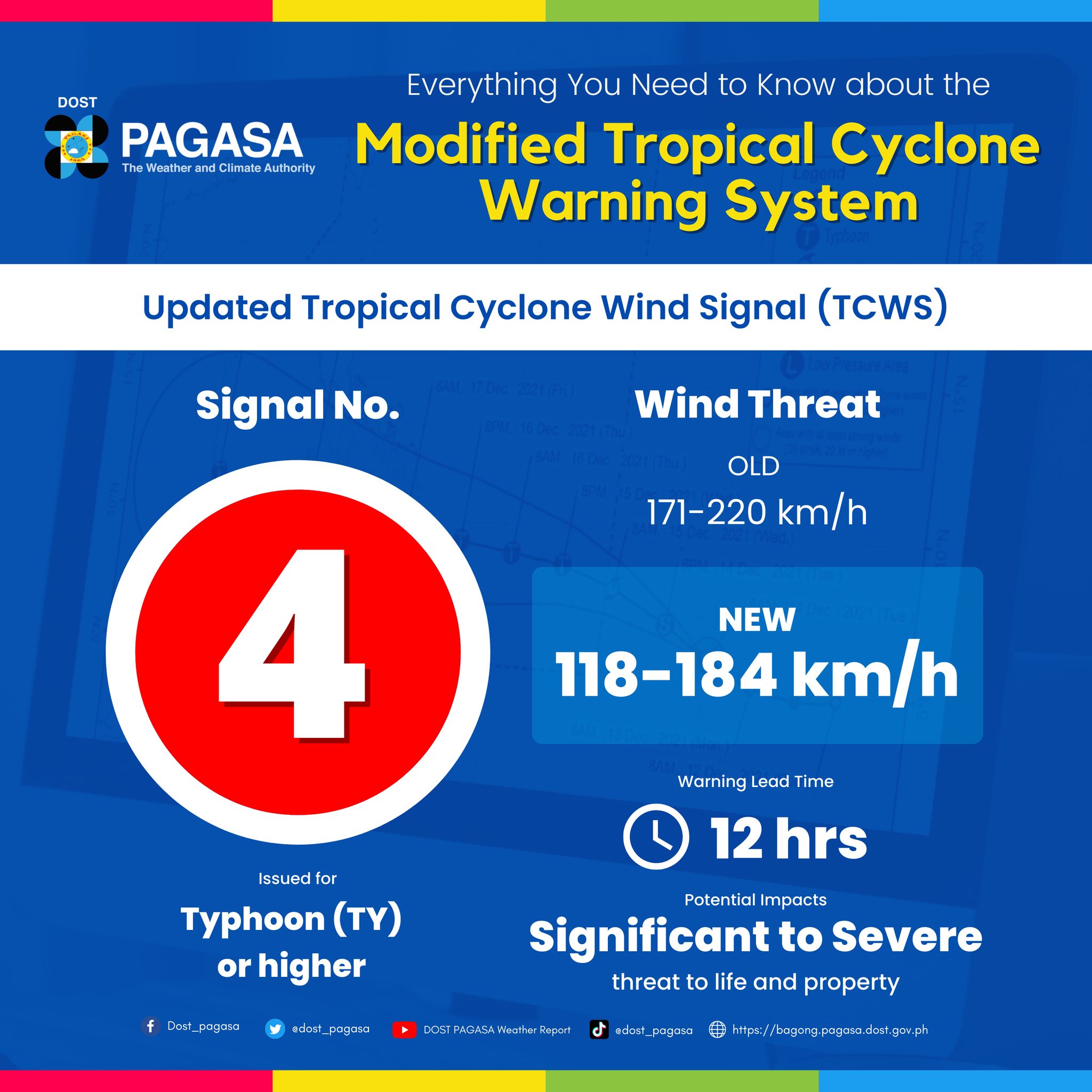
WIND THREAT: 118-184 km/h (64-99 kt, 32.7-51.2 m/s)
WARNING LEAD TIME: 12 hours
POTENTIAL IMPACTS:
- Severe damage will occur to makeshift or old, dilapidated of light structures, and other structures made of light materials. Houses of poor or average construction may receive major damage, including complete roof failure and possible wall collapse; a few may suffer severe damage.
- Most well-constructed houses may sufer minor to moderate roof damage, with some houses experiencing major roof failure; blown out windows are also likely.
- Failure of aluminum and steel roofs and ceverings may occure in buildings at industrial parks.
- Some glass in most high-rise office buildings may be blown out; a few of these buildings may have minor to moderate damage and higher proportion of blown-out windows due to swaying.
- Considerable airborne debris willbe generated and may cause damage, injury, and possible fatalities.
- Near total loss of power supply and telecommunications due to numerous downed power lines, poles, and cellular towers. Diminished availability of potable water supply is also likely.
- Significant to severe disruption to public transportation.
- Significant damage to banana and similar plants. Most small tress and some large trees will be broken, defoliated, or uprooted. Almost total damage to rice and other crops.
Tropical Cyclone Wind Signal #5
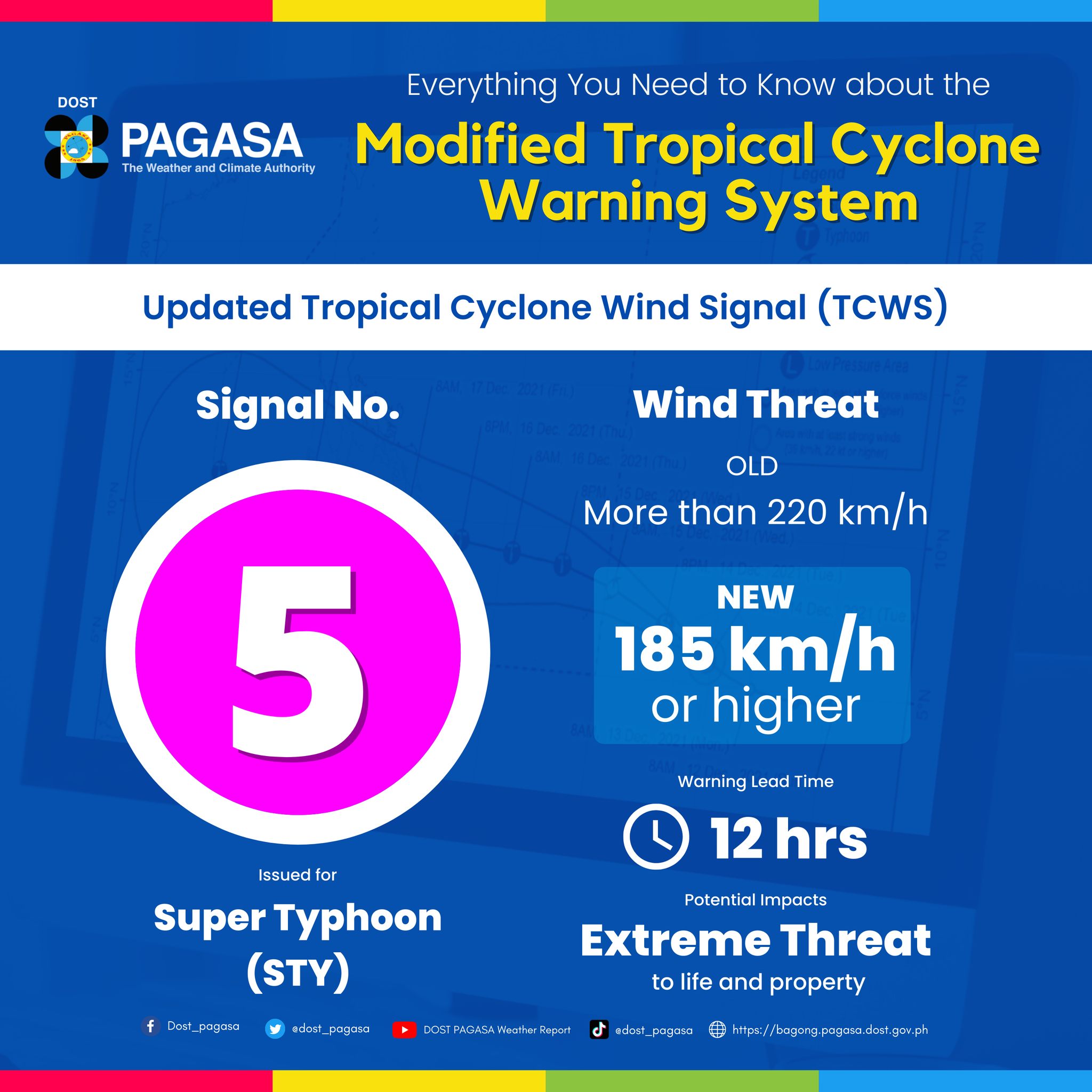
WIND THREAT: 185 km/h or higher (100 kt or higher, 51.3 m/s or higher)
WARNING LEAD TIME: 12 hours
POTENTIAL IMPACTS:
- Severe to catasrophic damage is expected to houses of poor or average construction, makeshift or old, dilapidated structures, and other structures made of light materials. Well-constructed houses may suffer substatial roof and wall failure or damage.
- Many industrial buildings will be destroyed, with only few receiving partial roof and wall damage.
- Most windows will be blowdn out n high-rise office buildings; Moderate structural damage is possible due to swaying.
- Extensive damage will be cause by airborne debris. People, pets, and livestock exposed to the wind are at great risk of injury or death.
- Electricity, potable water supply, and telecommunications will be unavailable for prolonged periods due to significant disruption in infrastructure.
- Prolonged significant to severe disruption to pucblic transportation.
- Vast majority of the trees will be broken, defoliated, or unrooted. Banana and similar plants will be extensively damaged. Few strees, plants, and crops will survive.