Blackburn with Darwen
Blackburn with Darwen is a borough and unitary authority area in Lancashire, North West England. It consists of the towns of Blackburn and Darwen but covers a wider area which includes the villages of Lower Darwen, Feniscowles, Brownhill and Hoddlesden.Notable Places in the Area
Turton and Entwistle Reservoir
Reservoir

Photo: Liz Dawson, CC BY-SA 2.0.
Turton and Entwistle Reservoir is a water reservoir in the village of Edgworth, Lancashire, England.
St Barnabas' Church, Darwen
Church
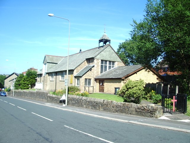
Photo: Alexander P Kapp, CC BY-SA 2.0.
St Barnabas' Church is on Watery Lane, Darwen, Lancashire, England.
Darwen railway station
Railway station
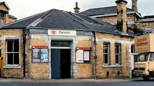
Photo: Albert Bridge, CC BY-SA 2.0.
Darwen railway station serves Darwen, a town in Lancashire, England. Darwen railway station is situated 2 miles north of Blackburn with Darwen.
Localities in the Area
Darwen
Town
Darwen is a market town and civil parish in the Blackburn with Darwen borough in Lancashire, England.
Belmont
Village

Photo: Gary Rogers, CC BY-SA 2.0.
Belmont is a village and former civil parish, now in the parish of North Turton, in the unitary authority area of Blackburn with Darwen, in the ceremonial county of Lancashire, England. Belmont is situated 2 miles southwest of Blackburn with Darwen.
Hoddlesden
Village
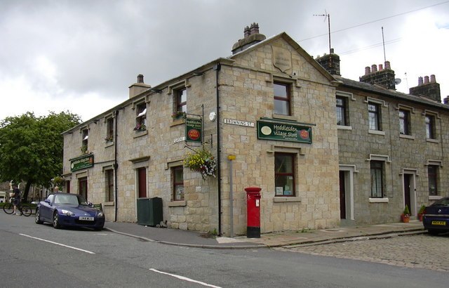
Photo: robert wade, CC BY-SA 2.0.
Hoddlesden is a village in the borough of Blackburn with Darwen, in Lancashire, England. Hoddlesden is situated 2½ miles northeast of Blackburn with Darwen.
Blackburn with Darwen
- Type: borough in the United Kingdom with 147,000 residents
- Description: unitary authority area in Lancashire, North West England
- Location: England, United Kingdom, Britain and Ireland, Europe
- View on OpenStreetMap
Latitude
53.6667° or 53° 40' northLongitude
-2.4667° or 2° 28' westPopulation
147,000Elevation
1,079 feet (329 metres)Abbreviation
BBDOpen Location Code
9C5VMG8M+M8GeoNames ID
3333126Wikidata ID
Q880782Blackburn with Darwen Satellite Map
© OpenStreetMap, Mapbox and Maxar
Also Known As
- Bengali: ব্ল্যাকবার্ন-ও-ডারওয়েন
- Cebuano: Blackburn with Darwen
- Chinese: Blackburn with Darwen
- Chinese: 布力般-達溫
- Chinese: 布莱克本-达文
- Chinese: 布莱克本-達文
- Chinese: 布萊克本-達文
- Dutch: Blackburn with Darwen
- English: Blackburn
- English: Borough of Blackburn with Darwen
- Esperanto: Blackburn with Darwen
- Estonian: Blackburn with Darwen
- French: Blackburn Et Darwen
- French: Blackburn avec Darwen
- French: Blackburn et Darwen
- French: Blackburn et darwen
- French: Blackburn with Darwen
- German: Blackburn with Darwen
- Gujarati: બ્લેકબર્ન વિથ ડાર્વેન
- Italian: Blackburn with Darwen
- Japanese: ブラックバーン・ウィズ・ダーウェン
- Kannada: ಡಾರ್ವೆನ್ನೊಂದಿಗೆ ಬ್ಲ್ಯಾಕ್ಬರ್ನ್
- Korean: 블랙번위드다언
- Luxembourgish: Blackburn an Darwen
- Min Nan Chinese: Blackburn kap Darwen
- Min Nan Chinese: Blackburn with Darwen
- Northern Frisian: Blackburn with Darwen
- Norwegian: Blackburn with Darwen
- Norwegian Bokmål: Blackburn with Darwen
- Polish: Blackburn with Darwen
- Portuguese: Blackburn with Darwen
- Romanian: Blackburn with Darwen
- Romanian: Blackburn with darwen
- Russian: Блэкберн-уит-Даруэн
- Slovak: Blackburn with Darwen
- Spanish: Blackburn with Darwen
- Swedish: Blackburn with Darwen
- Tamil: ப்ளாக்கபூரின் வித் டாரவென்
- Telugu: బ్లాక్ బర్న్ విత్ డార్విన్
- Turkish: Blackburn ile Darwen
- Ukrainian: Блекберн і Дарвен
- Urdu: بلیکبرن مع ڈاروین
- Welsh: Bwrdeistref Blackburn gyda Darwen
- Yue Chinese: 布力般-達溫
Localities in the Area
- Bull HillLocality
- Pennine MoorsArea
- BlacksnapeHamlet
- EgertonVillage, 3 miles southeast
- Pickup BankHamlet, 3 miles northeast
Landmarks in the Area
- Cartridge HillPeak
- Turton HeightsPeak
- Rushton's HeightHill
- Entwistle railway stationRailway station, 2½ miles east
- Spitlers EdgePeak, 2½ miles southwest
Popular Destinations in England
Discover London, Manchester, Sheffield and Leeds.
Escape to a Random Place
Discover other destinations in the world.
About Mapcarta. Thanks to Mapbox for providing amazing maps. Text is available under the CC BY-SA 4.0 license, excluding photos, directions and the map. Description text is based on the Wikipdia page Blackburn with Darwen. Photo: sidibousaid, CC BY 2.0.