Horse Trading in the negotiation of the 1948 Upper Colorado River Basin Compact (and its implications today)

There was deep tension in Cheyenne, Wyoming, in September 1947 as the negotiators for the Upper Colorado River Basin states gathered to try to hammer out a deal to divvy up their share of the Colorado’s water.

The 1922 Compact had split the river in two at Lee Ferry, and left for later the question of how to divide up the upper and lower divisions’ shares of the river among the respective regions’ states. By September 1947, the Upper Division states had been meeting off and on for more than a year, but progress was slow, stymied by a lack of the detailed water supply and use data some negotiators had hoped for.

Wyoming wanted to move quickly. As Eric Kuhn, my Utton Center colleague Rin Tara, and I write in a new paper:

Alluding to comments made by Utah’s Governor Maw earlier in the day, (federal commissioner Harry) Bashore suggested “the Commission attempt to negotiate this compact on the basis of percentage without attempting a lot of fine-haired calculations as to what the water is because it will change from year to year.” Adding that he was putting it to them plainly and “was not pulling any punches,” Bashore noted he would like “you folks on the Commission to do the same thing.”

Wyoming’s L. C. Bishop immediately responded that there was no need to wait for the report of the Engineering Committee. It was now time “to go ahead and negotiate the compact with the information we have.” He further noted that there are more lands than there is water, so it was time for the horse trading. Colorado’s Stone objected, noting “maybe in the end there will be an element of horse-trading in it, but Colorado feels we shouldn’t trade horses in the dark,” but added “there is an end and a limit to engineering studies and adding that there was much that could be done while the engineering work was being completed.”

The paper builds on Eric’s exhaustive review of the Upper Basin Compact negotiations, something which strangely we couldn’t find that any Colorado River Basin scholar had done in at the level of detail we felt was needed to understand the roots of today’s conflicts over questions still shrouded in ambiguity:

  • How do we quantify consumptive use in the Colorado River Basin?
  • How much water must the Upper Basin send down past Lee Ferry to users in the Lower Basin?

A Horse Named the Stream Depletion Theory

Stone’s argument against horse trading held for a time, and it was not until the marathon seventh negotiating meeting the following July that the horse trading finally began. The results have profound implications for modern Colorado River management.

To get to a final agreement, at the urging of Wyoming’s Wehrli, Bashore suggested the Commission break for a series of states only and state-to-state caucuses. It was also now time for Bashore to conduct some shuttle diplomacy. Stone, who up until this point had resisted any “horse trading,” realized he now needed to make some trades. He needed a horse named “The Stream Depletion Theory.” It appears that to get that horse, he gave Wyoming a horse named “A 14% Apportionment.”

The meaning of that language – “stream depletion theory” – is arcane, but the implications today are profound. Colorado pushed hard to argue that Upper Basin use should be measured not be diversions less return flows at each point along the river, but rather by the total impact of each state’s actions on the river’s flow at Lee Ferry. To win Wyoming’s backing, Stone offered Wyoming a juicy entitlement.

The result, eventually enshrined in the Upper Basin Compact, has profound effects on today’s arguments over Colorado River water.


Capability, Dignity, and Albuquerque’s San Mateo Inn

My city councilor, Tammy Fiebelkorn, gets it.

Here’s what she said about the city of Albuquerque’s purchase of an old motel in our neighborhood to use as transitional housing for young people (18 – 25) on the edge of homelessness:

The San Mateo Inn is across the street from a bus stop, a short drive from the University of New Mexico or Central New Mexico Community College, and adjacent to many businesses.

“It’s near a lot of different job opportunities, so they can actually be here and be getting job assistance,” Councilor Tammy Fiebelkorn said. The location is also in the middle of District 7, which Fiebelkorn represents.

“It’s also around a lot of fun things to do. I think it’s really important that when we’re putting together a shelter for unhoused people of any age, but particularly young people, we do it where they’re able to access fun. We want them to be part of our community,” she said.

We want them to be part of our community.

In his foundational work on the moral underpinnings of development economics, the Nobel laureate Amartya Sen (as much moral philosopher as economist) talks about the importance of “capability” – creating the opportunities for people to do and be that which they have reason to value.

Like bus lines, and access to jobs. That’s the kind of stuff Sen is talking about.

In her extension of Sen’s work, philosopher Martha Nussbaum anchors capability in fundamental human dignity. “We (should) do it where they’re able to access fun. We want them to be part of our community.” That’s what Sen and Nussbaum are talking about.

It’s not just about getting people off the street. It’s about their capabilities and dignity.

New Mexico 2024 End of May Reservoir Storage

Graph showing blue line for southern New Mexico Reservoir storage and red line for northern New Mexico, showing decline through the 2000s

Still running on empty

With the snow mostly melted, it’s time for a fresh look at the water storage situation on New Mexico’s Rio Grande – water saved from the spring runoff this year, and carried over from previous years, to use for irrigation, municipal use, and environmental flows during the summer. Total reservoir storage got a bump up last year, but we’ve already drawn down a significant fraction of the gains.

By going back to 1980, the graph above gives a clear picture of the shift from wet to dry as the millennial drought/aridification set in. Within the first few years of the 2000s, we burned through the accumulated bounty of the 1990s. It’s also useful to drill down to the last two decades.

A line graph depicting historical and projected fluctuations in the water storage levels for northern and southern reservoir groups within New Mexico's Rio Grande system from 2005 to 2025. The red line shows the northern reservoirs (Heron, El Vado, Abiquiu, Cochiti) experiencing a sharp peak around 2010, followed by a steep decline and then more moderate variations. The blue line for the southern reservoirs (Elephant Butte, Caballo) displays a dramatic rise and fall pattern, reaching its highest level around 2010 before plummeting, then showing alternating periods of recovery and depletion with a projected increase by 2025. The graph highlights the cyclical nature of water storage challenges faced by this vital river system.

Running on empty 2

Inkstain’s content will always be free. Thanks to my supporters for help keep the lights on and the coffee flowing.

N.B.: My code to generate this matches today’s number with the same day in all previous years. For completeness, here’s the graph of the entire dataset at a daily timestep for those who prefer it.

A line graph showing the combined storage levels of northern and southern reservoirs in New Mexico's Rio Grande system from 1980 to May 2024, measured in acre feet. Northern reservoirs show consistently lower levels than southern reservoirs, with both groups experiencing a significant decline in storage since the late 1990s.

Running on empty 3

End of Season Wrap-Up – Holding on to What We’ve Got

A guest post by Jack Schmidt, director of the Center for Colorado River Studies at Utah State University

By Jack Schmidt | May 22, 2024

Opportunities to rebuild basin-wide reservoir storage have been rare in the 21st century.

On April 3 2024, the snow accumulation season in the Colorado River watershed ended and the snow water equivalent of the snowpack of the Upper Basin peaked. Two weeks later on April 17, the watershed’s reservoirs1 dipped to their lowest level of the year. Now runoff is underway, and the watershed’s reservoirs are beginning to refill. This is a good time to assess how well water managers did during the past nine months to retain the bounty of 2023’s excellent runoff season, an essential part of rebuilding reservoir storage and regaining basin-wide water supply security.

The good news is that water managers did quite well, and reservoirs lost only 26% of the total amount accumulated during the 2023 runoff season. This was the smallest loss of any year in the last decade. Most of the decrease in storage that followed last year’s snowmelt inflow occurred in Upper Basin reservoirs, and Lake Mead and Lake Powell lost only 5% of the storage that accumulated in those two reservoirs. It is imperative that water managers continue to work to reduce consumptive uses, reduce losses, and retain the bounty of the few unusually wet years of the 21st century, as they did following the 2023 snowmelt.

Opportunities to rebuild basin-wide reservoir storage have been rare in the 21st century, and there have been many years in which there is significant risk of basin-wide reservoir storage depletion. Hydrologic and reservoir storage data between 2014 and 2023 indicate that annual snowmelt-derived gains in reservoir storage exceeded losses when natural flow at Lees Ferry exceeded 13.7 million acre feet per year (af/yr). Annual flows less than this amount occurred in 16 years of the 21st century. Opportunities to significantly rebuild basin-wide reservoir storage existed when natural flow exceeded 15.8 million af/yr, which only occurred six times in the 21st century. Development of a sustainable policy for managing Colorado River reservoir storage must focus on reducing consumptive uses and losses in both wet and dry years.

To recap, the natural flow of the Colorado River at Lees Ferry in 2023 was the third highest of the 21st century and was exceeded only in 2011 and 2019 (Table 1). Unregulated inflow to Lake Powell in Water Year (WY) 2023 was ~13.4 million af2.

Table 1

In response to this large runoff, the basin’s reservoirs recovered a significant amount of storage. The watershed’s reservoirs reached their maximum in mid-July (13 July 2023) when total storage was 29.7 million af. The increase in basin storage between mid-April and mid-July was 8.38 million af and was the largest single-year increase in storage in the last decade, and approximately 1 million af more than the increase in storage that had resulted from the inflows of 2019 (Table 2).

Table 2

However, the runoff in 2023 did not eliminate critically low reservoir storage conditions. The increased reservoir storage that peaked in mid-July 2023 recovered storage to the amount it had been in mid-February 2021 in the early stages of the 2020-2022 water crisis (Fig. 1). Based on average annual water consumption3 2023’s runoff would need to be repeated five more times to refill the reservoir system. Good runoff years rarely occur consecutively. The projected unregulated inflow to Lake Powell in 2024 is estimated to be only 81% of average.

Figure 1

Figure 1. Graph showing reservoir storage in the Colorado River basin between 1 January 1999 and 1 May 2024. Note that at the peak of storage in mid-July 2023, the total stored water supply was the same as it had been in mid-February 2021.

When we entered mid-summer 2023, I expressed concern about water managers’ ability to conserve the benefit of 2023’s runoff season, because we had not done so in previous years of good runoff. In those years, the benefit of reservoir storage recovery was not retained for more than two years (see blog post from October 2023). The benefit of 2011, the largest runoff of the 21st century, had been completely consumed in 19 months, and the benefit of large runoff in 2019 had been consumed in 24 months. I suggested that public understanding about the status of reservoir storage and the need to conserve the bounty of good years would be improved if water managers regularly reported how much of the previous year’s inflow benefit was retained. Such a metric could highlight success in rebuilding water storage or could be used to sound a warning of the need for additional conservation.

Throughout winter and early spring 2023 and 2024, I reported on the status of reservoir storage and showed that water managers were successfully conserving reservoir storage. Between mid-July (13 July 2023) and mid-April (17 April 2024), total basin-wide reservoir storage lost only 2.2 million af (Fig. 2) which was 26% of the total “gains” of the 2023 snowmelt season. Most of this decrease in storage occurred upstream from Lake Powell, where reservoirs lost 1.4 million af. In contrast, storage in the Lake Powell-Lake Mead reservoir system decreased by only 0.83 million af.

Figure 2

Figure 2. Graph showing reservoir storage in the Colorado River basin between 1 January 2023 and 1 May 2024.

The percentage of the accumulated snowmelt in 2023 that was consumed or otherwise lost from reservoirs in the subsequent months was less than in any other year of the past decade and was less than following the 2019 runoff season and significantly less than the years between 2014 and 2017 when runoff was moderately good (Table 2). I compared the rate and magnitude of decrease of reservoir storage in 2023-2024 with similar data for the previous nine years. The results are presented in a complicated Figure 3. Each line on this graph is the loss in storage in each year, plotted as the cumulative decrease in storage from the peak that had occurred in early summer. Lines that plot higher on this graph reflect smaller decreases in basin storage. The decrease in storage was notably large after the 2020 snowmelt season; total basin storage was nearly 7 million af less in spring 2021 than it had been in summer 2020. There were also large reductions after the snowmelt inflows of 2018 and 2021. In contrast, the reduction in storage after the 2023 runoff season (the thick blue line) was smaller than in the other years; this pattern is reflected by the thick blue line that plots higher on Figure 3 than in most other years.

Figure 3

Figure 3. Graph showing the decrease in reservoir storage during late summer, fall, winter, and early spring following each year’s snowmelt season.

Although the combined storage contents of Lake Mead and Lake Powell reflect the balance (or imbalance) between basin water supply and consumptive use, the trajectories of individual reservoirs also result from reservoir operational rules specific to each facility. Lake Powell reached its peak storage of the year in early July (8 July 2023; 9.67 million af) and subsequently lost 2 million af by mid-April, because water was transferred downstream (Fig. 4). Storage began to accumulate again in Lake Powell in mid-April (18 April 2024). In contrast, storage in Lake Mead steadily increased between August 2022 and early March (4 March 2024), gaining 2.7 million af of storage. Lake Mead has been losing storage since early March.

Figure 4

Figure 4. Graph showing the distribution of reservoir storage in different parts of the Colorado River basin between 1 January 2021 and 1 May 2024.

The trajectory of storage in Upper Basin reservoirs differed between those facilities authorized or linked to the Colorado River Storage Project (CRSP)4 in contrast to other facilities (Fig. 4). Peak storage upstream from Lake Powell peaked in early (facilities unrelated to the CRSP peaked on 5 July 2023 at 3.69 million af ) to mid-July (CRSP related facilities peaked on 15 July 2023 at 5.79 million af). Storage in facilities unrelated to the CRSP was quickly reduced to approximately 3 million af by mid-September, and storage was maintained at that quantity until the beginning of the 2024 snowmelt season. In contrast, storage in CRSP related facilities progressively lost storage of approximately 0.8 million af until mid-February 2024 when storage stabilized at approximately 5 million af. The longer period of declining storage in CRSP-related facilities was caused by policies related to transferring water to Lake Powell.

Insights about the Future

The data and analyses presented above provide insight about the likely trajectory of future Colorado Basin reservoir storage if no changes are made in policies concerning consumptive use and reservoir operations. During the past decade, the increase in basin-wide reservoir storage is well predicted by a power function based on the natural flow at Lees Ferry5 (Fig. 5).

Figure 5

Figure 5. Graph showing the relationship between annual natural flow at Lees Ferry and increase to basin-wide total storage during the snowmelt inflow season between 2014 and 2023.

The proportion of snowmelt-derived gain in storage subsequently lost during the following nine months is well predicted as an inverse power function6 of the increase in storage. The greater the increase in storage, the smaller the proportion of that increase subsequently lost. In years when there is little increase in storage, basin-wide consumptive uses and losses far exceeded the annual increase in storage (Fig. 6). Such was the case in 2018 and between 2020 and 2022.

Figure 6

Figure 6. Graph showing the proportion of the annual accumulated reservoir storage consumed or lost during the following nine months prior to the beginning of the next runoff season.

These correlations indicate that annual consumption and losses in excess of annual storage gains occurred when gains were less than approximately 3.2 million af. Between 2014 and 2023, storage gains were less than this amount when natural flows were less than approximately 13.7 million af, which occurred in 16 years of the Millennium Drought. Significant retention of reservoir storage, defined as retention of at least 50% of the annual accumulation, occurred when storage increased by at least 5.7 million af. Such an increase of storage only occurred when natural runoff exceeded 15.8 million af (Fig. 5), which only occurred six times between 2000 and 2023.

Take-Home Messages

The essential purpose of negotiating new reservoir operational guidelines for the Colorado River basin is to maintain sufficient reservoir storage to provide a reliable and secure water supply. At the beginning of the 2024 snowmelt season, basin-wide reservoir storage is comparable to what it was in late spring 2021, demonstrating that the Millennium Drought water crisis persists. The opportunity for significant retention of the benefits of significant increases in reservoir storage exist when natural flow exceeds approximately 15.8 million af, a situation that has rarely occurred since 2000. When natural flow is less than approximately 13.7 million af, there is significant risk of depletion of basin-wide storage. Development of a sustainable policy for managing Colorado River reservoir storage must focus on reducing consumptive uses and losses in both wet and dry years.

 1. In this post, “total watershed reservoir storage” or “total basin storage” are defined as the total storage in 46 reservoirs reported by the Bureau of Reclamation in its hydrologic database. These reservoirs do not include those in Lower Basin tributary watersheds and do not include a few smaller reservoirs in the Upper Basin.
2. The estimated natural flow at Lees Ferry is greater than the estimated unregulated inflow to Lake Powell, because natural flow is an estimation of what the river flow would be in the absence of humans, whereas unregulated inflow is the estimation of inflow in the absence of upstream reservoirs but with existing consumptive uses and losses.
3. Average annual consumptive uses and losses in the Colorado River, including reservoir evaporation and use in Mexico was 15.0 million af/yr between 2001-2020, based on Bureau of Reclamation reports. Between 2016 and 2020, consumptive uses and losses averaged 14.5 million af/yr.
4. Facilities authorized by or linked to the CRSP include Flaming Gorge, Navajo, Blue Mesa, Fontenelle, Morrow Point, and Crystal reservoirs.
5.  y = (1.5699 * 10-22) (x3.9677); R2 = 0.96, where y is increase in basin reservoir storage during the snowmelt season and x is the annual natural flow at Lees Ferry in the same year.
6. y = (4.7903 * 107) (x-1.1806); R2 = 0.99, where y is the proportion of the increase in storage consumed or otherwise lost in the subsequent nine months and x is the increase in storage during that snowmelt season.
We encourage the use of these figures in your own work with appropriate credit (Jack Schmidt, Center for Colorado River Studies). Please contact us if higher resolution images are required.

Blooming Hedgehog

Red blooming cactus with tan rock and spiderwebs glistening in the sunlight

Hedgehog cactus. Photo (and cactus) by L. Heineman.

Hedgehog Cactcus, blooming ride, with driveway and car in the background

Hedgehog cactus. Photo (and cactus) by L. Heineman.

Lissa has been nurturing this hedgehog cactus since we brought it back from Tucson a couple of years ago, wondering if it would survive our Albuquerque winters.

This morning, it started putting on a show.


To’Hajiilee water line groundbreaking: “an impossible project”

Large tan water tank reservoir in the background, party tent in mid-ground, people milling about, a line of shovels in a pile of dirt in the foreground.

An impossibility.

With the obligatory shovels in pre-softened dirt, a group of political leaders from the Navajo Nation, New Mexico state and local government, and water agencies this morning (Wed. 5/15/2024) formally inaugurated a new pipeline being built to connect the Navajo community of To’Hajiilee to the 3.5 million gallon reservoir in the picture – clean, piped water to a community that now has one working well and water so bad no one drinks it.

One of the oldtimers who’d been working on it for more than two decades walked up to me and said, “This is an impossible project.”

What he meant was that the project had overcome seemingly insurmountable hurdles in the interactions between a welter of government agencies with overlapping jurisdictions and sometimes incompatible responsibilities.

I went to the event wearing two hats – as a member of the Albuquerque Bernalillo County Water Utility Authority’s Technical Customer Advisory Committee, and on behalf of the Utton Center, which has a long history of working on Native American water stuff. (I was literally wearing my ABCWUA gimme cap, I don’t have an Utton one.)

To’Hajiilee, 35-ish miles west of Albuquerque, has six water wells. Five have already failed. The sixth is regularly off line. When it’s down, they have to shut down school and the clinic. When it’s working, the water is awful.

The vision statement from the Universal Access to Clean Water For Tribal Communities project is simple: “Every Native American has the right to clean, safe, affordable water in the home ensuring a minimum quality of life.”

In this 1999 book Development as Freedom, the Nobel laureate economist and moral philosopher Amartya Sen explains freedoms as “the capabilities that a person has, that is, the substantive freedoms he or she enjoys to lead the kind of life he or she has reason to value.”

“Rights” are tricky political terrain, because they’re often framed in negative terms – the absence of coercion or interference from others, particularly the state. But Sen’s making an affirmative argument here. It is not enough for the collective to simply get out of the individual’s way. The collective has an affirmative moral obligation to create the conditions under which the individual can flourish – to pursue that which they “have reason to value,” to repeat Sen. That’s sorta what my friends at the Universal Access project are saying with their vision statement.

At the urging of a colleague, I’ve been reading Sen lately in an effort to make sense of the moral underpinnings of the collective choices we face as we cope with the reality of less water. (For those familiar with Sen, know that I am not reading the mathy parts – they’re impenetrable!)

The Plumbing – Physical and Financial

The Albuquerque Bernalillo County Water Utility’s 7W reservoir, the tan thing in the picture, sits on high ground midway between Albuquerque and To’Hajiilee, a perfect water source for the community. In eighteen months under the current construction schedule, we’ll have a 7 mile pipe from here to there.

If the tally in my notes is correct (don’t hold me to this, I’m not a real journalist any more), it’s a ~$20 million project, with a mix of federal, state, and Navajo Nation funding.

The actual water in the pipes is the result of a fascinating agreement between the Navajo Nation and the Jicarilla Apache Nation in norther New Mexico. The Navajo Nation will lease Jicarailla water, which will be wheeled down the San Juan River, into the Rio Grande, and then diverted by the Albuquerque Bernalillo County Water Utility Authority, treated, and pumped up to 7W.

The Struggles to Get This Done

Former Bernalillo County Commissioner Debbie O’Malley, speaking at the groundbreaking, told the story of the bare-knuckle politics it took to overcome the intransigence of a landowner that stood in the way of the project – Western Albuquerque Land Holdings. And for sure, O’Malley and the group she worked with deserve a ton of credit for the use of their knuckles at a critical point in the struggle to get the pipeline built.

But more important is the community of To’Hajiilee itself, people like Mark Begay, my colleague on the Albuquerque water utility’s Technical Customer Advisory Committee. For decades, Begay and the other leaders in To’Hajiilee acted on behalf of their community to pursue “that which they had reason to value” – water!

This is about the community’s own collective agency, “the result of collective processes and collective actions in which people’s interactions shape their common destiny.” (Oscar Garza-Vázquez)

It was a joy to share the celebration of their success. I’ll be back in 18 months when they open the taps.


Finding an alternative place to park Middle Rio Grande water options with El Vado Dam out of service

Two key takeaways from Monday’s (May 13, 2024) Middle Rio Grande Conservancy District board meeting:

  • El Vado Dam, crucial for managing irrigation, municipal, and environmental water through New Mexico’s Middle Rio Grande valley, will be out of service indefinitely – for many, many years.
  • The vague structure of alternative storage options, using other existing dams, is beginning to take shape.

El Vado, built in the 1930s on the Rio Chama, has been out of service since 2022 for rehabilitation work by the US Bureau of Reclamation’s dam safety program. Challenges in fixing it have sent Reclamation’s engineering team back to the drawing boards. Work was supposed to be done by 2025. It’s now clear that the dam will be out of service for the foreseeable future.

Without the ability to store some of each year’s spring runoff for use in late summer and fall, the Rio Grande through Albuquerque is at the mercy of summer rains, without which it will dwindle to near nothing every year unless or until El Vado is fixed or we sort out alternative storage arrangements.

More on this part – the status of trying to fix El Vado – in a separate post to come later (once I write it I’ll add a link here), because the more important bits at Monday’s meeting involved the first cagey public discussions about what we will do in the meantime.

(Inkstain is reader supported.)

Exploring Water Storage Alternatives for the Middle Rio Grande

The always quotable Socorro farmer and MRGCD board member Glen Duggins offered a simple plea: “Just give us somewhere to park our water.”

Much of Monday’s discussion – sometimes explicit, sometimes in coded language – focused on this question.

If you look at the monthly reservoir storage graphic from Reclamation printed as a handout for Monday’s meeting (printed as a handout for every meeting), you’ll see there are two other reservoirs flanking El Vado upstream and downstream, and they have enough empty space in them to make up for most, if not all, of El Vado’s now unusable ~180,000 acre feet of capacity.

  • Abiquiu Reservoir currently has ~100,000 acre feet of available storage space
  • Heron Reservoir has ~300,000 acre feet of available storage space

But the details of using them for this new purpose, storing Middle Valley irrigation and environmental water, which is different than the purposes for which they were built, are staggeringly tricky.

Abiquiu

Abiquiu Reservoir, built in the 1960s by the U.S. Army Corps of Engineers on the Rio Chama as part of a massive federally funded project to protect the Middle Rio Grande Valley from flooding, is huge.

In 1981, Congress authorized a change in use to allow imported San Juan-Chama water to be stored in Abiquiu – up to 200,000 acre feet. (It requires an act of Congress.) Subsequent to that, the Albuquerque Bernalillo County Water Utility Authority got a storage permit from the New Mexico Office of the State Engineer (Storage requires a state permit, I hope you can see what I’m doing with the parentheticals.) to store its SJC water in Abiquiu. Then in 2020 another act of Congress did something I’m a bit confused about that allowed native water storage, not just San Juan-Chama water, and maybe more than the 200,000 acre feet, I think (Note: Another act of Congress required.) And then the Army Corps of Engineers had to rewrite its water operations manual, which nearly four years later is just now being completed. (It requires not only an act of Congress to change the purpose of use at Abiquiu, but also a lengthy Corps process to rewrite its rules.)

My Utton Center colleagues are far smarter than I about these institutional nuances – Utton has long worked on the legal plumbing – but I wasn’t about to wake them up at 6 in the morning, so you’re stuck with me.

(John catches breath and microwaves the last of his morning coffee, which had grown cold – thanks to Inkstain supporters who chipped in to help pay for said coffee, I really need it this morning!)

So yes, there is space in Abiquiu for us to park our water. But the rules tangle is of Gordian proportions.

Heron

Upstream, Heron Reservoir sits on a tributary to the Chama, built in the 1970s to store water imported beneath the continental divide from three Colorado River headwaters streams. It seems ill-suited for storing Rio Grande water.

It currently holds ~100,000 acre feet of imported San Juan-Chama project water, with room for another ~300,000 acre feet. (Note bene: I’m rounding all the numbers off here to one or a few significant digits.) The trick here is to hold the San Juan-Chama water in Heron and then do a series of carryover accounting and maybe native water swaps that I can’t begin to understand, let alone explain, in order to kinda sorta use Heron as well.

The negotiations

One of the reasons the discussions about all of this at yesterday’s board meeting were kinda vague is that the three parties crucial to cutting the Gordian tangle – MRGCD, the Bureau of Reclamation, and the Albuquerque Bernalillo County Water Utility Authority – are in negotiations about what sort of parenthetical agreements might be needed to make it all work.

They need space to sort out thorny incentive problems – the interests of the municipal water utility to protect and manage its own municipal supply will be key. In this regard alone, it my be in the water utility’s best interests to help. Low late summer river flows, which are inevitable without storage, force the utility to switch to groundwater pumping to get water to my tap. As a result, the aquifer recovery, of which we are rightly proud in Albuquerque, has stalled.

Also key will be the broader community interests of flowing ditches and a flowing river, which while not directly related to ABCWUA’s water supply nevertheless may be things the water utility’s board members – city councilors and county commissioners – care about.

The typically blunt Duggins was unusually cryptic at Monday’s meeting, but I infer this is what he was talking about when he said: “We’re neighbors. I don’t understand why it would take a year or two to get papers signed.”

El Vado Reservoir update on today’s (May 13, 2024) Middle Rio Grande Conservancy District board agenda

We’ll get an update on the status of El Vado Dam and related issues at this afternoon’s (Mon. 5/13/24) meeting of the Middle Rio Grande Conservancy District’s board of directors. This is an enormously consequential issue for Rio Grande flows through central New Mexico.

The Meeting

Today’s board meeting starts at 3 p.m. at the District’s main offices, 931 Second Street SW in Albuquerque (between the National Hispanic Cultural Center and Bueno Foods, a bit of geography I’ve always loved). The first substantive item on the agenda is a presentation by Wayne Pullan, the Bureau of Reclamation’s Upper Colorado River Regional Director. This is a clue. Regional directors suggest an elevation in the issue’s importance. (Zoom link can be found here.)

The Dam

Built in the 1930s, the dam is a critical piece of infrastructure for managing the river’s flow. Built to store water during the high spring runoff season for use in late summer and fall, it is critical for both irrigation in the valley and, increasingly, for environmental flows.

We’ve been unable to store water in El Vado for the last two years, as the Bureau of Reclamation’s dam safety engineering corps tries to fix it. As I wrote here last month, the repair process isn’t going well, and we’ll likely be without it for a number of years. Without El Vado storage water, late season irrigation and environmental flows in the Middle Valley will be extremely low for the foreseeable future.

Short Term Prospects

Multi-colored graph of Rio Grande flow at Albuquerque, showing early 2024 runoff peak and current decline.

A very early peak.

Without El Vado (and also subject to Rio Grande Compact operating rules, which further constrain our degrees of freedom in managing the river, see here), we’re looking at a “run of the river” system, which means any irrigation and environmental flows depend on what comes down the river from melting show in the mountains to the north. As you can see in the graph of flows at Albuquerque’s Central Avenue Bridge, the river this year peaked in late April, more than three week’s before the May 13 peak modeled by Reclamation in its mid-April modeling runs.

This is extremely early even relative to the shift we’ve already seen to an earlier runoff peak as the climate warms.

For now, there’s still plenty of water in the river through Albuquerque for fish spawning and irrigation. Flow at the Central Avenue Bridge is ~2,000 cubic feet per second, MRGCD diversions are currently ~650 cubic feet per second, and there’s still ~1,800 cubic feet per second coming out the bottom of the system into Elephant Butte Reservoir.

Medium to long term prospects

Our medium to long term prospects are murky. We don’t know:

  • how long it’ll take to fix El Vado
  • whether and how we’ll be able to fix our compact problems, which place a second constraint on our ability to store spring runoff for use in summer
  • whether we’ll be able to come up with an institutional fix that might, in the absence of El Vado, enable us to store water in another upstream reservoir, such as the Corps of Engineers’ Abiquiu Reservoir

My hope is that the discussion at today’s MRGCD meeting might clear away some of the murk (see earlier mention that Reclamation’s regional director is on the agenda)

Inkstain is reader supported

I used to get paid to cover the hell out of stuff like this for the Albuquerque Journal, to sit in meetings like today’s and use my words to help y’all make sense of it all. It was then, and remains, a labor of love.

My current business model is weird. UNM’s Utton Center has given me a part-time home (thanks, taxpayers!) and a smart group of colleagues with a shared passion. Without Utton, and my amazing colleagues, this wouldn’t be possible.

But the blog is just me, up before dawn reading the latest snowpack reports and streamflow numbers and typing away, and I’m appreciative of Inkstain’s supporters who help keep the lights on and the metaphorical caffeine flowing.

Floating Albuquerque’s Rio Grande: notes on “naturalness”

Paddle board with backpack and paddle handle, river in the background with trees on either side and a bridge in the distance. The river is muddy brown.

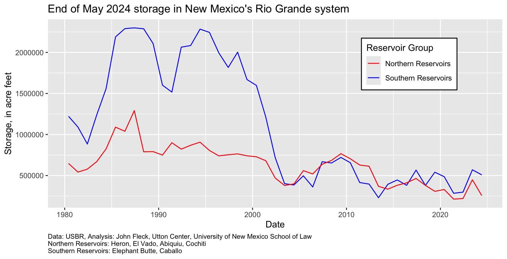
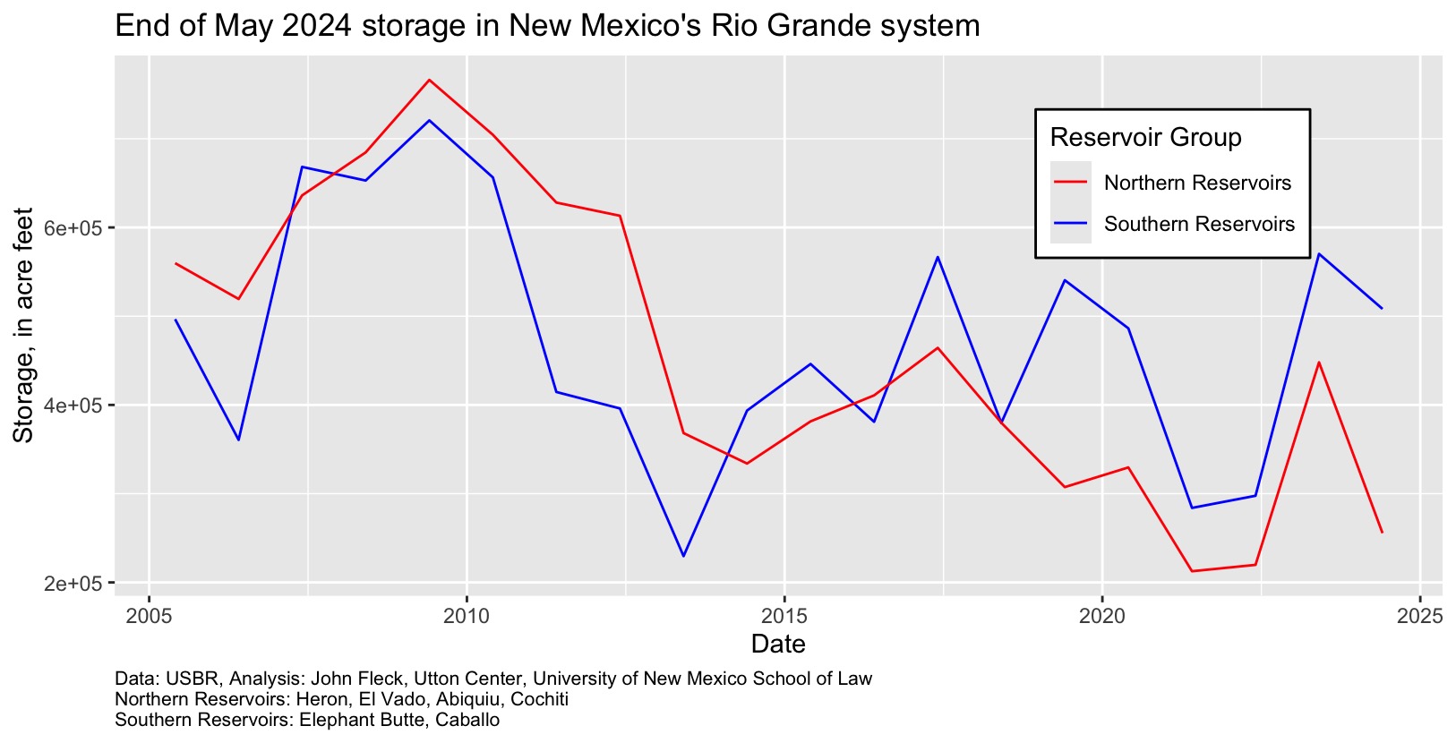
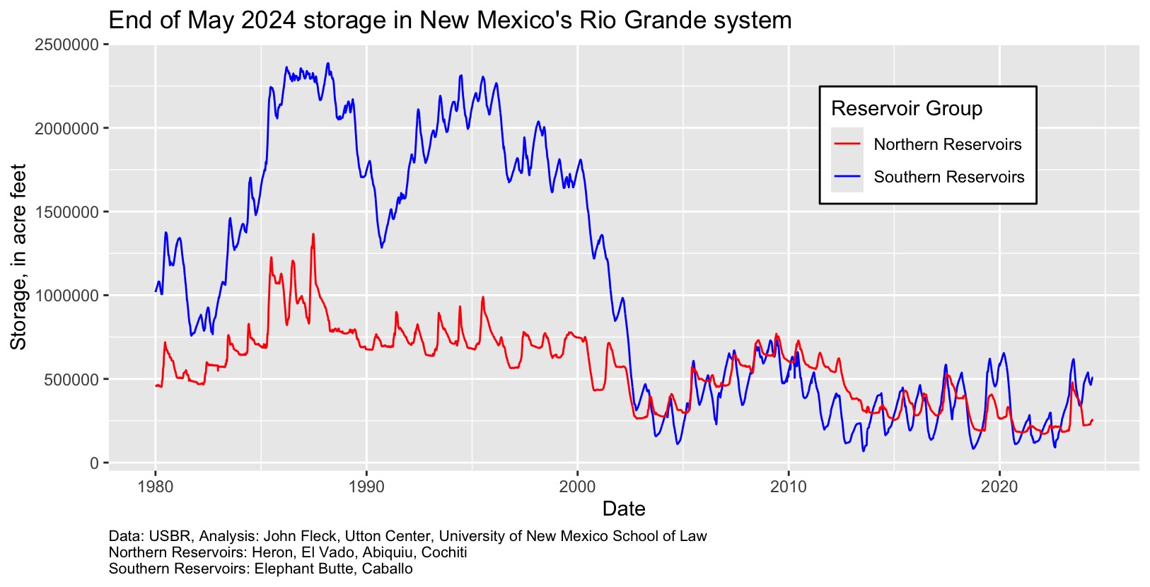
A proper celebration

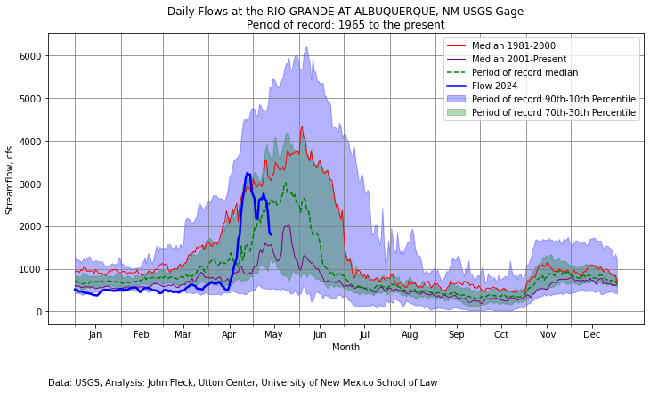
The Rio Grande is up through Albuquerque right now, swollen with spring snowmelt. But not for long. We may already have hit the runoff peak at a bit above 3,000 cubic feet per second in late April, and a friend who’s been cheerfully nagging me to float it with them talked me into locking down Tuesday, May 7, for a boat trip, before the flows got so low that “float” turns into “walk and drag your boat over the sand bars”.

My friend and I both work on, write about, talk about, and think about the Rio Grande for a living, which is weird – that such careers exist. But despite my deep engagement with this river, I have spent little time in and on the river itself. I walk and bike the trails alongside the river all the time, a relationship magnified by spending the last four years writing a book about the relationship between Albuquerque and its river. I feel a deep intimacy with the Rio Grande.

But I have only actually floated it a handful of times.

Naturalness

Brown river, blue sky, trees flanking the river, a paddler paddling a boat in the distance

In the midst of a city, naturalness.


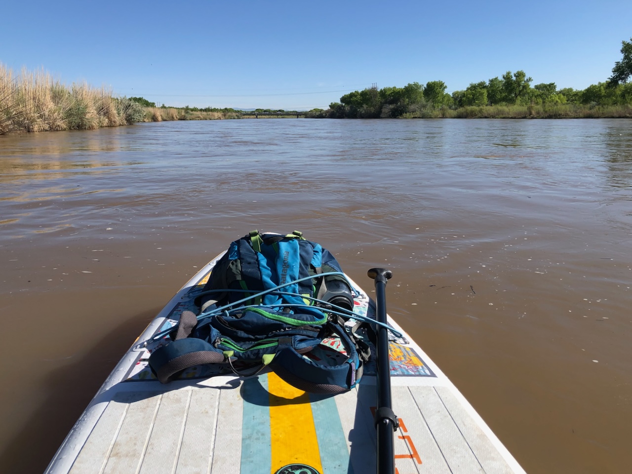
Floating the Rio Grande through the heart of Albuquerque is striking. We were in the midst of a metropolitan area of nearly a million people. But once we drifted under the morning commute jam on the highway known as “Paseo del Norte” on the north end of town, the traffic noise dimmed and the forest lining the river enveloped us.

As the river shrinks from drought, climate change, and human water use, sandbars have become thickly forested islands. Cormorants, drawn from the south by a combination of a warming climate and the stocked fishing ponds just off the river near downtown (I love the second reason.), have colonized this stretch of the river, sentinels on river snags hunting breakfast.

Ducks and geese and flitty little birds I cannot name sullenly took flight as we neared. Cottonwoods and a host of other trees, both longtime residents and recent immigrants, hung over the banks. A lone turkey vulture, my first of the year, waited to complete the cycle underway all around us.

But the river is playing a trick on us.

If the cormorants weren’t enough of what in poker would be called the river’s “tell,” the swallows were the giveaway, swarming each bridge, the concrete ledges stand-ins for the cliffs from which some of their number draw the names humans have bestowed upon them. My friend told me turkey vultures have the best sense of smell of any animal on earth, that oil companies sometimes add vulture attractants to pipelines that the birds might help them find leaks. I was skeptical, as is my way, but delighted, as also is my way.

I have always loved the conversational rhythm of a bike ride with a friend – often deep, but fragmented by decisions and revisions, channeled by the ride’s geographical flow, providing a narrative structure to be filled in. Floating a river, though I have done it far less, offers the same feel. I can see why Mark Twain settled into it as a literary device.

Boating, with fewer stop signs and traffic lights and left and right turns, offers more space for conversation than cycling, and yesterday’s was particularly rich because it placed my friend and I unavoidably in the midst of a landscape of ideas we have been exploring.

Just past the Montaño bridge, we paddled over toward river right (did I get the lingo?) and drifted down the bank past an old oxbow cut off from the main channel by the U.S. Bureau of Reclamation’s river realignment project in the 1950s. A sandbar that crept out into the main channel in 2020 from the oxbow’s margin has been colonized with willows that last year withstood what could, thanks to the dictates of upstream flood management, be the largest flow they’ll ever see. It is a sandbar making the transition to forest.

I have biked and walked to the sand bar from the landward side often over the last four years, trying to make sense of the story the place is telling us. (There’s a whole chapter about it in the new book.) Yesterday was my first time seeing it from the water.

Linking history to hydrology makes this stretch a storytelling lode. Off to the east, old acequias – urban streams – flow along twisting paths they’ve occupied for more than three centuries. The Rio Grande’s main channel here is less than 75 years old. I mine this lode to explore, in conversation and writing, what we mean by “natural.”

In a fascinating paper that crossed my electronic desk this week, Dutch landscape planner Paul Opdam noodles around the idea of “naturalness.” He’s not talking here about any inherent qualities in the thing, but rather evidence from the research literature about characteristics that people perceive. What makes us think of a landscape as “natural?” Opdam’s review suggests a number of characteristics:

  • Curvy shapes
  • Vegetation succession, where older growth is perceived as more “natural”
  • Phenomena like flowing streams
  • Diverse wildlife
  • Water features
  • Plant diversity
  • Landscape heterogeneity

Opdam is not pursuing some understanding of what is “truly natural.” He is talking about a built environment. What matters to him is what people perceive as natural, based on the premise that such a perception of naturalness conveys benefits.

Before large-scale human intervention, the Rio Grande wandered a wide flood plain through what is now Albuquerque. Beginning less than a century ago, we pinned it between levees down the narrow strip my friend and I were floating. With river locked in place, and upstream water use and flood control dams changing the river’s hydrology, our beloved cottonwood forest opportunistically took hold.

It used to annoy me that people thought of the results as “natural.” The cottonwoods here are weeds in a sidewalk crack, former John would grumble. But in my old age (the float trip was part of my extended 65th birthday celebration), I have mellowed on this point. Whatever its origin story, we love the bosque. It may be an unintended side effect of river engineering on a massive scale, but it’s got big trees and diverse wildlife, and oh, the water features! Opdam’s paper suggests the question of whether things are in some a priori sense “natural” is beside the point.

My friend and I batted this back and forth. Voltaire’s Candide paid us a visit. Here’s how Bob and I put it in the new book:

Candide’s final wisdom is most often translated from the original French thus: “We must cultivate our garden.” But modern translations from Voltaire’s “Il faut cultiver notre jardin” suggests a more expansive interpretation, the garden not as the plot of land behind the house but as a more expansive landscape: “We must work our land.” Translating “jardin” as “fields” or “land” suggests a broader space, encompassing not just one’s personal environment but also the larger community.

An urban river

The underside of a bridge, with orange columns covered with graffit and a river in the foreground.

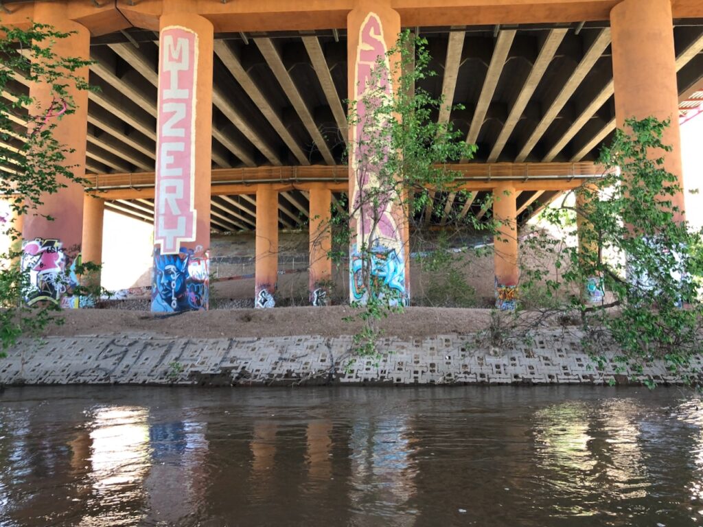
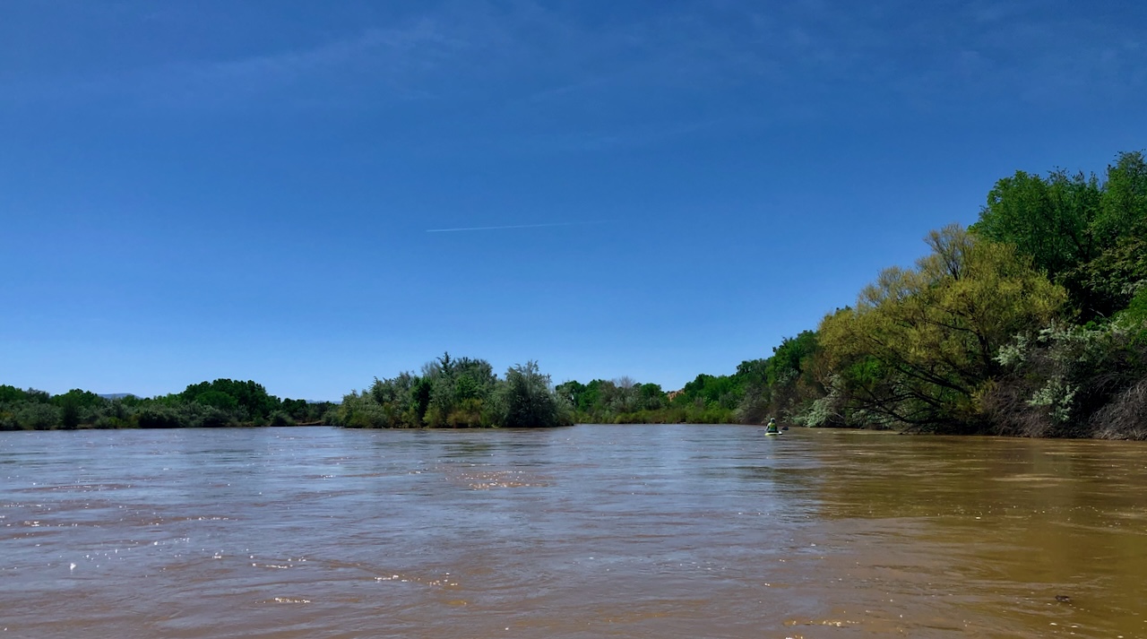
The Rio Grande beneath the interstate, Albuquerque, May 2024.

The Interstate 40 bridge over the Rio Grande in the heart of Albuquerque is another of my favorite river places. Art on bridge pilings is ever present up and down this stretch of the river, and this has some of my favorites. This spot likely doesn’t meet most of Opdam’s “naturalness” criteria, but I love it too.

From the interstate down to our takeout at the Route 66 Bridge, it felt like we were back in a city again. But the deeper point in all of this blathering is that the river as it is today, the bosque, and the city are all of a piece. We would not have any one without the others.

Tending this garden is the task ahead.

Postscript: I notice that the bridge graffiti picture is a little jittery, out of focus, which means my friend will have to take me out on the river again. Plus there’s some more graffiti river left I’d like a picture of.

New Colorado River Guidelines are Only the Beginning

Much attention is focused right now on rewriting Colorado River operating rules, to replace the soon-to-expire 2007 reservoir operating guidelines. But there is a growing frustration that the struggle to solve that relatively narrow problem “mass balance” problem (how much water, and where?) leaves out a range of incredibly important issues:

If a reminder of this reality were needed, it was provided in the majority of comments submitted as part of the EIS scoping process, summarized by Reclamation as urging a “more holistic view of the system to include the integrity and health of the river and its tributaries,” a perspective which, among other things, includes a consideration of “environmental justice,” “preserving natural and cultural values,” and “acknowledging and incorporating the rights and authorities of all Basin sovereigns.”

That’s from a new policy brief from my friends and colleagues at the Colorado River Research Group, a collaborative of researchers across the basin whose mission is to provide “an independent, scientific voice for the future of the Colorado River.” The brief grew out of conversations among the group’s members about both the strengths, as well as the shortcomings, of the current process.

We are mindful that much of what CRRG has been advocating for is directly on the table in the various proposals now being considered for post-2026 river management:

New and improved reservoir management strategies are clearly needed and, at a minimum, will need to accomplish the following items discussed in earlier Colorado River Research Group (CRRG) publications:

  • Address those rules that have institutionalized the structural deficit, largely at the expense of
    protecting (and recovering) reservoir storage;
  • Better integrate the latest science about climate change and ongoing basin aridification, as well as real-time seasonal weather data, into the planning and operational framework;
  • Improve incentives, opportunities, and mechanisms for all water users to participate in
    conservation programs and other efforts promoting system flexibility and resilience; and,
  • Interface with new agreements with Mexico focused on protecting reservoir levels, habitat
    restoration, and shortage-sharing.

But there are so many other important issues left untouched by the P26 process (sorry, yes, some of us have started shortening it to “P26”) that the list we came up with among CRRG members is too long to blockquote here in a blog post – click through to read the white paper, it’s not too long.

What we advocate for in the paper is that the other issues not be lost in our rush to solve the mass balance problem.