
 Home
Home  Membership
  Customer Support
  Create
  Blog
Blog 
Continents and Oceans Word Mat
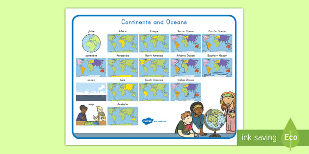
Using the Continent and Ocean Map Printable
Are you looking for a great word mat to help your students learn the names and locations of the worlds’ continents and oceans? Would you like a fantastic resource that does just that? Check out Twinkl’s brilliant Continent and Ocean Map Printable! It contains pictures of the seven continents and five oceans, plus pictorial definitions of the globe, a map, continents, and oceans. You could laminate copies for each table, display it as a poster, or have your kids paste it into their workbooks. Whichever you choose, it’ll really help them name and identify the oceans and continents that make up Planet Earth.
For all of your World Oceans Day needs, check out Twinkl’s collection of first grade resources. If you want to learn more about the oceans, our Teaching Wiki is very informative, and to explore ocean conservation, our blog is well worth a read. All of Twinkl’s resources have been created by talented, inspirational teachers for the use of everyone who educates. They’re written to educational standards too, which means they’re top-quality and age-appropriate. The Continent and Ocean Map Printable is ready for immediate download and printing, which saves you a ton of time. And it’s an Eco resource, so even printing in full color uses less ink, which also saves you money!
Related Searches
 continents
world map
ocean names
geography
continents cut and stick
oceans
map
continents and oceans ks1
habitat
continents and oceans
word mats
water bodies
games
continents
world map
ocean names
geography
continents cut and stick
oceans
map
continents and oceans ks1
habitat
continents and oceans
word mats
water bodies
games
- Ratings & Reviews
- Curriculum Links
- Make a Request
- Resource Updates
- Twinkl added Super-Eco-Color 5 years ago
Using the Continent and Ocean Map Printable
Are you looking for a great word mat to help your students learn the names and locations of the worlds’ continents and oceans? Would you like a fantastic resource that does just that? Check out Twinkl’s brilliant Continent and Ocean Map Printable! It contains pictures of the seven continents and five oceans, plus pictorial definitions of the globe, a map, continents, and oceans. You could laminate copies for each table, display it as a poster, or have your kids paste it into their workbooks. Whichever you choose, it’ll really help them name and identify the oceans and continents that make up Planet Earth.
For all of your World Oceans Day needs, check out Twinkl’s collection of first grade resources. If you want to learn more about the oceans, our Teaching Wiki is very informative, and to explore ocean conservation, our blog is well worth a read. All of Twinkl’s resources have been created by talented, inspirational teachers for the use of everyone who educates. They’re written to educational standards too, which means they’re top-quality and age-appropriate. The Continent and Ocean Map Printable is ready for immediate download and printing, which saves you a ton of time. And it’s an Eco resource, so even printing in full color uses less ink, which also saves you money!
More Twinkl Favorites
Now that you’ve added the Continent and Ocean Map Printable to your teaching toolkit, see what else Twinkl can offer you.
Help you students develop their literacy and sound skills with our Ocean Life Beginning Sounds Worksheet. They’ll circle the sounds that each of the beautifully drawn sea creatures starts with.
Twinkl’s Ocean Ending Sound Activity does the same for last sounds as the resource above does for beginning ones. Just print and laminate the cards, then your kids can use pegs or dry erase markers to choose the correct answer.
For a lot of fun, download the Wikki Stix World Ocean Day Diorama. It’s a brilliant science project that your kids are sure to love. They’ll create a diorama having integrated both quantitative and qualitative information into their work.
How much of the seafloor has been mapped?
- The Ancient Egyptians were the first to measure the depth of the sea bed. They use poles, then weighted ropes when the ocean became too deep.
- In the 1870s, the British ship HMS Challenger was able to measure deeper using winches and wires, but still took a long time.
- Between the 1920s and the 1970s, mapping of the sea floor developed using sound waves.
- Multibeam sonar and photon-counting lidar have been developed between the US Navy, the National Oceanic and Atmospheric Administration, and NASA.
- At present (May 2023), just under 25% of the seafloor has been mapped. We know more about the surface of the moon than the ocean floor!