Carmel High School
Carmel High School is a public high school in Carmel, Indiana, United States, and part of the Carmel Clay Schools District.Notable Places in the Area
The Palladium at the Center for the Performing Arts
Theater building
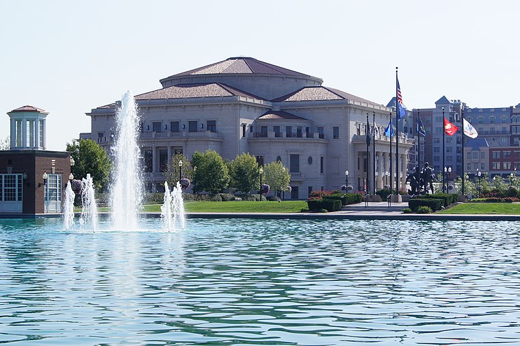
Photo: TheSongbook, CC BY-SA 3.0.
The Palladium at the Center for the Performing Arts is 1,500-seat, 151,000-square-foot concert hall… The Palladium at the Center for the Performing Arts is situated 1 mile southwest of Carmel High School.
Localities in the Area
Carmel
 Carmel is a city of just over 100,000 people in the Nine-County Region of Indiana north of Indianapolis.
Home Place
Suburb
Home Place is a neighborhood within the city of Carmel, Indiana, in the United States. Home Place is situated 3 miles southwest of Carmel High School.

Carmel High School
- Type: School
- Description: Indiana high school
- Categories: high school and education
- Location: Clay Township, Hamilton, Indiana, Midwest, United States, North America
- View on OpenStreetMap
Latitude
39.97972° or 39° 58' 47" northLongitude
-86.11944° or 86° 7' 10" westElevation
850 feet (259 metres)Open Location Code
86FMXVHJ+V6OpenStreetMap ID
node 358683790OpenStreetMap Feature
amenity=schoolGeoNames ID
7316175Wikidata ID
Q5043286Carmel High School Satellite Map
© OpenStreetMap, Mapbox and Maxar
Also Known As
- Belarusian: Вышэйшая школа Кармел
- English: Carmel HS
- French: Carmel High School
- Hebrew: תיכון כרמל
- Irish: Ardscoil Carmel
- Japanese: カーメル高校
- Japanese: カーメル高等学校
- Swedish: Carmel High School
- Ukrainian: Середня школа Кармел
Other Places Named Carmel High School
Localities in the Area
- Newark VillageHamlet
- Echo CrestNeighborhood, 2 miles south
- Orchard ParkNeighborhood, 3 miles south
- Holaday Hills and DalesNeighborhood, 3 miles south
- Northern BeachHamlet, 3 miles southeast
Places in the Area
- WHJE-FM (Carmel)Tower
- CHTVRecording studio
- Carmel CafeCoffeehouse
- Carmel Youth Assistance ProgramSocial service facility, 780 feet south
- Carmel High School Natatorium Construction860 feet northeast
Popular Destinations in Indiana
Discover Indianapolis, Fort Wayne, Gary and Evansville.
Escape to a Random Place
Discover other schools in the world.
About Mapcarta. Thanks to Mapbox for providing amazing maps. Data © OpenStreetMap contributors and available under the Open Database License. Text is available under the CC BY-SA 4.0 license, excluding photos, directions and the map. Description text is based on the Wikipdia page Carmel High School. Photo: Wikimedia, CC0.