


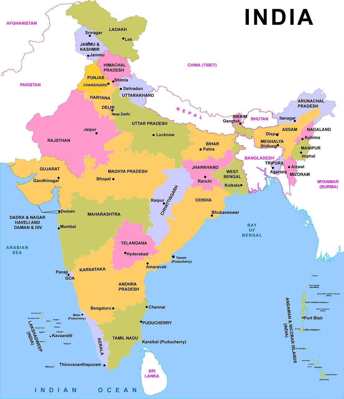


The Largest and Smallest States of India | Area, City, Population & More
S.No. State Name Area (km2)
1. Rajasthan 342,239
2. Madhya Pradesh 308,245
3. Maharashtra 307,713
4. Uttar Pradesh 243,286
5. Gujarat 196,024
6. Karnataka 191,791
7. Andhra Pradesh 160,205
8. Orissa 155,707
9. Chhattisgarh 135,194
10. Tamil Nadu 130,058
11. Telangana 112,077
12. Bihar 94,163
13. West Bengal 88,752
14. Arunachal Pradesh 83,743
15. Jharkhand 79,714
16. Assam 78,438
17. Himachal Pradesh 55,673
18. Uttarakhand 53,483
19. Punjab 50,362
20. Haryana 44,212
21. Kerala 38,863
22. Meghalaya 22,429
23. Manipur 22,327
24. Mizoram 21,087
25. Nagaland 16,579
26. Tripura 10,491
27. Sikkim 7,096
28. Goa 3,702
1. Rajasthan – The total area of the Indian state of Rajasthan is approximately 342,239 square kilometers (132,139 square miles). As of March 2023, there are 50 districts in Rajasthan. This is after the Rajasthan government announced the creation of 19 new districts on March 17, 2023. The new districts are. The borders of 5 states meet with the state of Rajasthan and the border of a neighboring country Pakistan is with this state.These state are Punjab to the north Haryana and Uttar Pradesh to the northeast Madhya Pradesh to the southeast Gujarat to the southwest Pakistan to the west and northwest. The current estimated population of Rajasthan state in 2023 is 8.36 crores (83.6 million).
2. Madhya Pradesh – Madhya Pradesh is spread over 308,245 square kilometers (119,016 square miles). According to the year 2023, there are 52 districts in Madhya Pradesh. The government of Madhya Pradesh plans to create three new districts in the near future, which will bring the total number of districts in the state to 55. The borders of 5 states meet in the state of Madhya Pradesh. These state are Uttar Pradesh to the northeast Chhattisgarh to the southeast Maharashtra to the south Gujarat to the west Rajasthan to the northwest. According to the 2011 census, the total population of Madhya Pradesh is 7,26,26,809.
3. Maharashtra – Maharashtra is the third largest state in India by area, covering an area of 307,713 square kilometers (118,809 square miles). There are currently 36 districts in Maharashtra.It is bordered by the states of Madhya Pradesh to the north, Chhattisgarh to the east, Telangana to the southeast, Karnataka to the south, Goa to the southwest, and Gujarat to the northwest. The state has a coastline of 720 kilometers (447 miles) along the Arabian Sea. The population of Maharashtra in 2023 is estimated to be 124,904,071. The population has grown by about 12 million people in the past 12 years.
4. Uttar Pradesh – Uttar Pradesh is spread over an area of 243,286 square kilometers (93,935 square miles), making it the fourth-largest state in India by area. It is roughly the same size as the United Kingdom. There are currently 75 districts in Uttar Pradesh.The state is bordered by Rajasthan to the west, Haryana, Himachal Pradesh and Delhi to the northwest, Uttarakhand and an international border with Nepal to the north, Bihar to the east, Madhya Pradesh to the south and also borderd by Chhattisgarh and Jharkhand. Uttar Pradesh is a very populous state, with a population of over 200 million people. It is the most populous state in India, and the second most populous country subdivision in the world. The state’s capital is Lucknow, and other major cities include Agra, Varanasi, Kanpur, and Allahabad.
5. Gujarat – Gujarat is the fifth-largest state in India by area, covering 196,024 square kilometers (75,685 square miles). There are currently 33 districts in Gujarat. It is bordered by Rajasthan to the northeast, Dadra and Nagar Haveli and Daman and Diu to the south, Maharashtra to the southeast, Madhya Pradesh to the east, and the Arabian Sea and the Pakistani province of Sindh to the west. The estimated population of Gujarat in 2023 is 71.5 million (7.15 crores).
6. Karnataka – Karnataka is spread over an area of 191,791 square kilometers (74,051 square miles), making it the sixth-largest state in India by area. There are currently 31 districts in Karnataka state. It is bordered by the Lakshadweep Sea to the west, Goa to the northwest, Maharashtra to the north, Telangana to the northeast, Andhra Pradesh to the east, Tamil Nadu to the southeast, and Kerala to the southwest. The total population of Karnataka in 2023 is estimated to be 67.6 million (6.76 crores).
7. Andhra Pradesh – The state of Andhra Pradesh is spread over an area of 160,205 square kilometers (62,024 square miles). It is the seventh-largest state in India by area. here are currently 26 districts in Andhra Pradesh. The number of districts in the state increased from 13 to 26 on April 4, 2022, after the Chief Minister, Jagan Mohan Reddy, announced the formation of new districts. The state is divided into two regions: Coastal Andhra and Rayalaseema. Coastal Andhra is located in the southeastern part of the state and is bounded by the Bay of Bengal to the east. Rayalaseema is located in the southwestern part of the state and is bounded by Telangana to the north, Karnataka to the west, and Tamil Nadu to the south. The total population of Andhra Pradesh in 2023 is estimated to be 52,883,163.
8. Orissa – Odisha, formerly known as Orissa, is a state in eastern India. It is spread over an area of 155,707 square kilometers (60,119 square miles), which is about 4.87% of the total area of India. As of September 2023, there are 30 districts in Odisha. He state is bounded by the Bay of Bengal to the east, Chhattisgarh to the west, Jharkhand and West Bengal to the north, and Andhra Pradesh and Telangana to the south. The current population of Odisha in 2023 is estimated to be 44.29 million (4.42 crores). This is based on the latest data from the Unique Identification Aadhar India, updated on March 31, 2022.
9. Chhattisgarh – Chhattisgarh is the 9th largest state in India by area, with a total area of 135,194 square kilometers (52,199 square miles). As of September 2023, there are 33 districts in Chhattisgarh. It is bordered by seven states: Uttar Pradesh to the north, Madhya Pradesh to the northwest, Maharashtra to the southwest, Jharkhand to the northeast, Odisha to the east, Telangana and Andhra Pradesh to the south. The current population of Chhattisgarh is estimated to be 32,199,722 as of 2023.
10. Tamil Nadu – The area of Tamil Nadu is 130,058 square kilometers (50,216 square miles). It is the tenth-largest state in India. There are currently 38 districts in Tamil Nadu. The latest addition was the newly formed district of Tenkasi, which was carved out of Tirunelveli district in 2022.The bordering states are Kerala to the west, Karnataka to the north-west and Andhra Pradesh to the north. To the east is the Bay of Bengal and the state encircles the union territory of Puducherry. The population of Tamil Nadu in 2023 is estimated to be 83.69 million (8.39 crores). This is based on the projected growth rate of 1.5% from the 2011 census, which recorded a population of 72.14 million (7.21 crores).
11. Telangana – The state has a total area of 112,077 square kilometers (43,272 square miles). Telangana is located in the southern part of India and is bordered by Maharashtra and Chhattisgarh to the north, Karnataka to the west, Andhra Pradesh to the south and east. As a population of over 35 million people. The capital of Telangana is Hyderabad. As of 2023, there are 33 districts in Telangana. Two new districts, Mulugu and Narayanpet, were created on 17 February 2019, taking the total number of districts from 31 to 33.
12. Bihar – Bihar is spread over an area of 94,163 square kilometers (36,357 square miles). There are currently 38 districts in Bihar. The newest district is Bagaha, which was carved out of the district of West Champaran in 2023. It is landlocked by Nepal in the north, Jharkhand in the south, West Bengal in the east, and Uttar Pradesh in the west. The current population of Bihar is estimated to be 126.7 million (12.67 crores) in 2023. This is an increase of around 1.89 crores from the 2011 census figure of 104.099 million (10.4 crores).
13. West Bengal – The area of West Bengal is 88,752 square kilometers (34,267 square miles). As of September 2023, there are 23 districts in West Bengal. The state is located in the eastern part of India, and it is bordered by the states of Sikkim, Assam, Bihar, Jharkhand, Odisha, and Bangladesh. The capital of West Bengal is Kolkata. The current population of West Bengal is estimated to be 102,552,787 as of 2023.
14. Arunachal Pradesh – Arunachal Pradesh is spread over an area of 83,743 square kilometers (32,333 square miles), making it the largest state in the northeast region of India. As of 2023, there are a total of 26 districts in Arunachal Pradesh. The state is bordered by Bhutan to the west, Myanmar to the east, China’s Tibet Autonomous Region to the north, and the Indian states of Assam and Nagaland to the south. The estimated population of Arunachal Pradesh in 2023 is 1,711,947. This is an increase of 10.54% from the 2011 census figure of 1,382,611.
15. Jharkhand – Jharkhand is spread over an area of 79,714 square kilometers (30,778 square miles). It is the 15th largest state by area in India. There are currently 24 districts in Jharkhand. The state shares its borders with West Bengal to the east, Chhattisgarh to the west, Uttar Pradesh to the northwest, Bihar to the north, and Odisha to the south. The estimated population of Jharkhand in 2023 is 39.4 million (3.94 crores).
16. Assam – The area of Assam is 78,438 square kilometers (30,285 square miles). It is the second largest state in terms of area in northeastern India. As of September 2023, there are 31 administrative districts in Assam. Assam is bordered by Bhutan and Arunachal Pradesh to the north; Nagaland, Arunachal Pradesh and Manipur to the east; Meghalaya, Tripura, Mizoram and Bangladesh to the south; and West Bengal to the west. The total population of Assam as of 2023 is estimated to be 34,586,234.
17. Himachal Pradesh – The area of Himachal Pradesh is 55,673 square kilometers (21,495 square miles). There are 12 districts in Himachal Pradesh. The state is located in the western Himalayas and is bordered by Jammu and Kashmir and Ladakh to the north, Punjab to the west, Haryana and Uttar Pradesh to the south, and Uttarakhand to the east. The total population of Himachal Pradesh in 2023 is estimated to be 7,750,000. This is an increase of about 12% from the 2011 census figure of 6,864,602.
18. Uttarakhand – The area of Uttarakhand is 53,483 square kilometers. There are currently 13 districts in Uttarakhand. Uttarakhand is a mountainous state located in the north-central part of India. It is bounded by the states of Himachal Pradesh to the west, Haryana and Uttar Pradesh to the south, and Nepal to the east. The northern part of the state is part of the Greater Himalayas, and includes some of the highest peaks in India. The estimated population of Uttarakhand in 2023 is 11,700,099.
19. Punjab – The area of Punjab in India is 50,362 square kilometers (19,445 square miles). There are currently 23 districts in Punjab, India. The newest district is Malerkotla, which was created in 2021 by bifurcating the Sangrur district. Punjab is bordered by Pakistan’s Punjab province on the west, Jammu and Kashmir on the north, Himachal Pradesh on the northeast and Haryana and Rajasthan on the south.
The population of Punjab, India is estimated to be 29,611,935 as of 2022/2023
20. Haryana – The area of Haryana is 44,212 square kilometers (17,070 square miles). There are currently 22 districts in Haryana. The latest of all the Haryana districts is Charkhi Dadri, which was formed in 2016. Haryana is a landlocked state in northern India. It is bordered by Punjab and Himachal Pradesh to the north, Rajasthan to the west and south, and Uttar Pradesh to the east.
The current population of Haryana is estimated to be 27,388,008 as of 2023. This is according to the Aadhaar statistics. The last census was conducted in 2011, and the population at that time was 25,353,081. This means that the population of Haryana has grown by 8.03% in the last 12 years
21.Kerala – Kerala is spread over an area of 38,863 square kilometers (15,005 square miles), making it the 21st largest Indian state by area. There are 14 districts in Kerala. It is bordered by Karnataka to the north and northeast, Tamil Nadu to the east and south, and the Lakshadweep Sea to the west. The total population of Kerala in 2023 is estimated to be 35.77 million (3.57 crores).
22. Meghalaya – The area of Meghalaya is 22,429 square kilometers. There are a total of 12 districts in Meghalaya. It is bounded by the Indian state of Assam to the north and northeast and by Bangladesh to the south and southwest. The state capital is the hill town of Shillong, located in east-central Meghalaya. he estimated population of Meghalaya in 2023 is 3,772,103. This is based on the latest available data from the 2011 census. The population growth rate of Meghalaya is 2.5% per year.
23. Manipur – The area of Manipur is 22,327 square kilometers (8,621 square miles). It is the 23rd largest state in India in terms of area. There are currently 16 districts in Manipur. The districts were created in 2016 by bifurcating the existing 9 districts. The state is bordered by Nagaland to the north, Mizoram to the south, Assam to the west, and Myanmar to the east. The capital of Manipur is Imphal. The total population of Manipur as of 2023 is estimated to be 3,008,546. This is an increase of about 5.5% from the 2011 census figure of 2,855,794.
24. Mizoram – The area of Mizoram is 21,087 square kilometers. It is the fifth smallest state of India. There are currently 11 districts in Mizoram. The three newest districts, Hnahthial, Saitual, and Khawzawl, were created in June 2019. It shares international borders with Myanmar and Bangladesh in the south, and domestic borders with Manipur, Assam, and Tripura in the north. The population of Mizoram in 2023 is estimated to be 1.238 million (12.38 Lakhs).
25. Nagaland – The area of Nagaland is 16,579 square kilometers (6,401 square miles).There are currently 16 districts in Nagaland. the newest district is Shamator, which was created in January 2022. It is bordered by the Indian states of Arunachal Pradesh to the north, Assam to the west, Manipur to the south, and the Sagaing Region of Myanmar to the east. The total population of Nagaland in 2023 is estimated to be 2.23 million (22.3 Lakhs).
26. Tripura – The area of Tripura is 10,491 square kilometers (4,051 square miles). It is the third-smallest state in India, after Goa and Sikkim. There are currently 8 districts in Tripura. The four new districts of Gomati, Khowai, Sipahijala and Unakoti were created on January 21, 2012. It is bordered by Bangladesh to the west, north, and south; and the Indian states of Assam to the north east; and Mizoram to the east. The current estimated population of Tripura is 4,057,847 as of 2022/2023.
27. Sikkim – The area of Sikkim is 7,096 square kilometers (2,740 square miles). It is the smallest state in India in terms of both area and population. There are currently 6 districts in Sikkim.
The two new districts of Sikkim, Soreng and Pakyong, were created on December 21, 2021. Sikkim is located in the eastern Himalayas and is bordered by Nepal to the west, Bhutan to the east, Tibet Autonomous Region of China to the north, and West Bengal to the south. The state is home to the world’s third-highest mountain, Kangchenjunga. The current population of Sikkim is estimated to be around 658,019 as of 2023.
28. Goa – The area of Goa is 3,702 square kilometers (1,429 square miles). There are only two districts in Goa. It is the smallest state in India by area and the fourth smallest by population. It is located on the southwestern coast of India, bordering the Arabian Sea. The capital of Goa is Panaji. The estimated population of Goa in 2023 is 1,542,750.