
 Home
Home  Membership
  TwinklCares
  Updated Help for 2022
  Catch-up Resources
  Home Learning Hub
  Create
  Blog
Blog 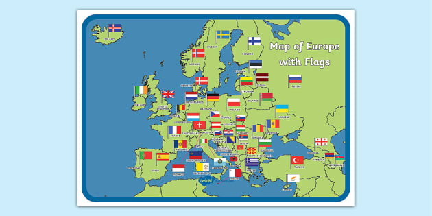
Map of Europe with Flags Display Poster
How can I use this Labelled Map of Europe?
Develop your learners’ knowledge of the countries that make up Europe with this Labelled Map of Europe Display Poster. It’s the perfect visual aid to support learning all about different European countries.
Related Searches
 europe
 map
europe flags
flags
europe eyfs
flags of europe
europe display
european map
european flags
flags of the world
spain
uk map
france
eurovision 2024
countries of europe
world map
place knowledge
geography
eyfs early years
europe
europe map
europe flags
flags
europe eyfs
flags of europe
europe display
european map
european flags
flags of the world
spain
uk map
france
eurovision 2024
countries of europe
world map
place knowledge
geography
eyfs early years
- Ratings & Reviews
- Curriculum Links
- Make a Request
- Resource Updates
-
thank you for sending me a map without flags.
-
Hello thesup162,
You're very welcome and I'm glad that we could help. 3 years ago
✔ Thank you for your feedback
-
-
Would it be possible to include Kosovo as well?
-
Hello steveodogbiscuit,
Thanks for your suggestion. I can see this being useful - I'll ask our design team to look into adding Kosovo for you. 4 years ago
✔ Thank you for your feedback -
Hi there steveodogbiscuit,
Our lovely resource creation team have created this and emailed the new resource to you! I hope you find it useful! 4 years ago
✔ Thank you for your feedback
-
-
Hi, is it possible to have this map with names but without flags?
-
Hello thesup162,
Thanks for taking the time to get in touch - I'll pass your idea over to our design team to see if we can make this change for you :) 3 years ago
✔ Thank you for your feedback -
Hi there thesup162,
Our lovely resource creation team have created this and emailed the new resource to you! I hope you find it useful! 3 years ago
✔ Thank you for your feedback
-
-
Scotland's flag is missing
-
Hello gillian.maccallum,
Thank you for your feedback. I'll get this resource checked right away! 4 years ago
✔ Thank you for your feedback
-
-
Please include Luxembourg on future versions
-
Hello pinkukelele,
Thanks for taking the time to get in touch - I'll ask our design team to take a look and see if we can add Luxembourg onto this map. I will also pass this feedback on for future versions :) 4 years ago
✔ Thank you for your feedback -
Hi there pinkukelele,
Our lovely resource creation team have completed this and emailed the new resource to you. It will be available on our website soon! I hope you like it! 4 years ago
✔ Thank you for your feedback
-
- Twinkl updated the Main Version 4 weeks ago
- Twinkl added 2xa3-cursive-version 10 months ago
- Twinkl added a3-cursive-version 10 months ago
- Twinkl added alternative uk black and white 2 years ago
- Twinkl added flag matching without countries 2 years ago
- Twinkl added 2xa3 version 2 years ago
- Twinkl added a3 version 3 years ago
- Twinkl added alternative uk 4 years ago
- Twinkl added 4xa4 version 5 years ago
- Twinkl added black and white version 6 years ago
- Twinkl added flag matching 6 years ago
- Twinkl added super eco colour 6 years ago
How can I use this Labelled Map of Europe?
Develop your learners’ knowledge of the countries that make up Europe with this Labelled Map of Europe Display Poster. It’s the perfect visual aid to support learning all about different European countries.
Download our full-colour version in just the click of a button to find a beautifully illustrated map of Europe. The map comes complete with all 44 country names, as well as their flags. Download and print in A4 size, or as a larger A3 poster. Ideal to display in your classroom or at home!
Alongside our full-colour map, you can also download our Black and White version. Why not print this out and challenge children to colour each country, and it’s flag? This could be a great activity to end a geography lesson all about Europe.
Not only this, but you can also download an editable version of our Labelled Map of Europe, as well as a version without flags. We even have a Matching Flags version that you can easily download and print. This would be a fantastic activity to consolidate learners’ knowledge of European flags. Can they cut out each flag and match it to the correct country on the map?
You could also use this map to prepare for our Great Class Quiz Off, along with our quick European Cities Matching Card Game. Discover even more fun ways to use our maps by watching our engaging video below!
How can I learn more about European countries?
Are you looking to improve your children’s knowledge of Europe? Or, perhaps you’re looking for fun activities to celebrate Europe Day, either in class or at home with your own children. No matter the reason, we’re here to help with our range of fantastic resources.
- Do your little ones enjoy a game of top trumps? Then they’re sure to love playing this European Countries Card Game. It’s a great way to engage children in learning key facts about each country in Europe.
- Reinforce learning of European flags with our Europe Flags Bingo Game. Use it as a whole-class activity or as a fun active station task for small groups of children. It’s perfect for assessing children’s knowledge in a fun and interactive way!
- If you're planning a topic on European countries, then check out our England Flag Bunting for a bit of classroom decoration. You can also find lots of other European country bunting on our website.
- For a fun arts and crafts activity, download this set of European Flags Colouring Pages. This is a great way to enhance children's fine motor skills and creativity.
What countries are in Europe?
In total, there are 44 countries in Europe. How many of them can you name? Here are some to get you started:
- United Kingdom;
- Russia;
- Denmark;
- Greece;
- Belgium;
- Germany;
- France;
- Italy;
- Spain;
- Poland.