Our favourite way to truly feel like we have ‘seen’ an area is to walk around as much as possible. Saltburn-by-the-Sea has so many lovely walks to choose from. In this blog post, we will share a selection of walks and highlight the best routes to take.
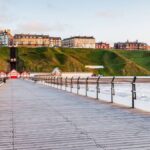
This North Yorkshire seaside town is famous for its surfing community, colourful events and fantastic walking trails. Saltburn-by-the-Sea is located on the Cleveland Way, a long-distance footpath that runs for 109 miles along the North York Moors and the Yorkshire Coast. So lace up your walking boots; here are our favourite Saltburn-by-the-Sea walks.
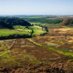
Saltburn Gill, a 52-acre woodland nature reserve

Saltburn Gill is a semi-natural woodland that has been present since 1600. A stream of the same name marks the western boundary of the reserve.
FREE Whitby Mini-Guide
"Get the best from your stay in Whitby." - Everything you need to know about Whitby into a free mini-guide!
It is a lovely example of the woodland that once covered East Cleveland. It has a mixture of Oak and Ash and a Hazel and Holly understorey. Although Wych Elm was once a common tree here, Sycamore was put in to replace it due to the arrival of Dutch elm disease, which must be carefully managed. The damp and humid conditions in the Gill also make it an ideal habitat for ferns to grow, with six different species recorded.
During spring, you can witness the beautiful yellow flowers of lesser celandine, followed by wild garlic and bluebells that spread across the area. You can also spot other plants such as dog’s mercury, woodruff, bugle, moschatel, and wood avens in the vicinity.
The reserve is home to diverse animal and plant life, so it has been designated a site of special scientific interest. If you stroll along the public footpath that runs through the entire length of the reserve, you will have plenty of opportunities to see all it has to offer.
Enjoy a walk through the woodland

Takes 1 hour | 3 km / 1.9 miles | Easy walk
To get to the Saltburn Gill reserve, head towards the Northumbrian Water pumping station (a large red brick building) from the car park below Cat Nab. Once you’re there, you’ll see a signposted public footpath – follow this for around 300 metres until you reach the gate, which marks the reserve’s entrance. From there, follow the footpath up to Lum Hole (where the bridleway and footpath cross), then retrace your steps back to the car park. Walking the length of the public footpath and back within the reserve boundary will take around an hour and cover 3 km.
The reserve is conveniently located close to Saltburn, so several amenities are easily accessible. You can enjoy food at The Ship Inn, open year-round, or one of the many beach cafes or fish and chip restaurants for refreshments. Toilet facilities are available at the Cat Nab car park.
Or the longer circular walk to Saltburn Cliffs

Takes 4 hours | 13 km / 8.1 miles | Moderate walk
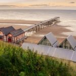
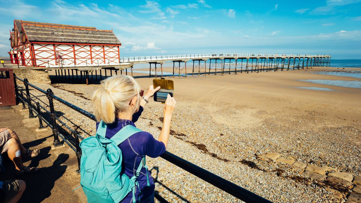
This walk features a mix of countryside and sea views, including the best viewpoint from which to admire Boulby Cliff—the highest cliff on the east coast of England. Enjoy views over the North York Moors and explore two nature reserves. Saltburn’s Inclined Tramway, Victorian pier and beautiful sandy beaches are nearby to complete your adventure.
Click here to follow the full route.
Skelton-in-Cleveland, a village located in the borough of Redcar and Cleveland

Skelton-in-Cleveland is a village near Saltburn-by-the-Sea, known for its historic architecture. The village is home to the ruins of a Norman castle, which was built in the 12th century and destroyed in the 14th century; now a current country house built between 1770 and 1817.
It is located on the edge of the North York Moors National Park, so visitors can enjoy exploring the surrounding woodlands, valleys, and hills. Skelton itself has a range of amenities, including shops, pubs, and restaurants, making it a great place to stop off during a visit to the area.
Saltburn to Skelton

Takes 1 hour 30 minutes | 4 km / 2.5 miles | Easy/moderate walk
Explore the Valley Gardens and surrounding woodlands by taking part in this easy-to-moderate linear walk. Take a moment to appreciate the stunning Italian Gardens. Crossing Skelton Beck beneath Saltburn’s rail viaduct, you’ll have a chance to capture some fantastic photos and explore the area’s rich archaeological history. This walk also includes a section of the renowned Cleveland Way.
This walk has two starting points. You can either begin at the Cat Nab car park or, if you arrive by bus or train, at Station Square, where you can take the first part of the walk.
You can take a local bus from Skelton High Street for your return journey, or if you prefer, you can extend your walk and enjoy the return journey in reverse.
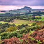
Roseberry Topping, a well-known landmark in the area

If you are in Saltburn, we recommend hiking to Roseberry Topping. This magnificent peak is close to Great Ayton and Newton under Roseberry. Roseberry Topping is a well-known landmark in the area, so much so that it is featured in the nearby Teesside International Airport logo. Standing at 1,049 feet, it offers breathtaking views from the summit.
There is a car park for those visiting Roseberry Topping; it is nearby on the A173 and maintained by the National Trust. This car park can get very busy, though, especially at weekends. A pay-and-display car park is 300 yards north of the National Trust car park, up the A173 road, and past the King’s Head Inn.
The quickest circular route to the top of Roseberry Topping

1 hour | 2.2 km / 1.4 miles | Easy, short but steep walk | Ideal for families
Beginning at the public car park is the quickest and most direct way to tackle Roseberry Topping. It is a 1.4-mile route, which you can complete in an hour, depending on your fitness level and how long you spend admiring the view!
We often do this walk with a young family. It takes an hour and is suitable for children 4+. This walk begins with a flat walk up Roseberry Lane, with Roseberry Topping in full view. From here, it’s a direct route to the top. We like to picnic when we reach the top to enjoy a view.
You can follow the entire route here.
Click here for more routes to Roseberry Topping if you are looking for more of a challenge!
Staithes, for a more challenging hike to a beautiful fishing village

Walking from Saltburn-by-the-Sea to Staithes is a popular route among hikers and nature enthusiasts. It offers stunning coastal views and a chance to explore the charming fishing village of Staithes. Along the way, you’ll pass through Skinningrove and Boulby, taking in the highest cliffs on the east coast of England. The route is 13.8 km long and takes around 4 hours and 30 minutes to complete. It has a moderate/difficult level of difficulty, making it a perfect day hike for those seeking a bit of a challenge and adventure.
Saltburn-by-the-Sea to Staithes via the Cleveland Way

Takes 4 hours 30 minutes | 13.8 km / 8.6 miles | Moderate/difficult walk
The first leg of the coastal trail begins at the end of Saltburn’s promenade. Walking, you’ll cross the Skelton Beck via the road bridge and gradually ascend uphill along the cliff’s edge. The trail path is between the cliff edge and a freight railway line. After leisurely descending into Skinningrove, you’ll cross the Kilton Beck and begin climbing again.
The path initially runs along the cliff edge before diverting inland after walking a mile. It continues to climb before re-joining the cliff edge. You will pass the cliffs at Boulby. After a steep descent leads to a road in Boulby, you’ll walk along a path to another road that eventually brings you down to the village of Staithes.
You can follow the entire route here.
The Cleveland Way

The Cleveland Way National Trail is a 109-mile (175 km) walking route officially opened on 24th May 1969. It was the second recognised National Trail in England and Wales. The Cleveland Way starts from the market town of Helmsley. Most people walk the route in a clockwise direction from Helmsley to Filey as you are likely to have the wind behind you.
It’s possible for most reasonably fit people to walk the Cleveland Way. Planning a route that suits your abilities is essential, as it can be challenging in certain areas. The Cleveland Hills and some coastal sections can be particularly demanding, but this can also enhance the overall experience. Although the route is well-marked, having an up-to-date map or GPS mapping is still advisable. Comfortable footwear is a must, and bringing a pair of binoculars will aid in spotting wildlife as you walk.
Click here for more information on the Cleveland Way walking routes.
From the stunning coastline views to the town’s friendly charm, there are many lovely walks in and around this area. So why not take a step outside and enjoy these walks around Saltburn?