


![National Geographic Road Atlas 2024: Adventure Edition [United States, Canada, Mexico]](https://images-na.ssl-images-amazon.com/images/I/71KaWaWuVjL._AC_UL165_SR165,165_.jpg)
![National Geographic Road Atlas 2024: Scenic Drives Edition [United States, Canada, Mexico] (National Geographic Recreation At](https://images-na.ssl-images-amazon.com/images/I/814R4OsGtCL._AC_UL165_SR165,165_.jpg)


I agree with the other reviewers. This is everything that a nice American road atlas for use at home or in the car should be. It is helpful at times to see the big picture instead of the Google Maps version. For those who order the one with vinyl cover, just wanted to clarify. I wasn't sure if I was ordering the standard atlas but with a vinyl plastic cover or the standard atlas inside a plastic slip cover; it is the latter. See photo. It is like a well-fitting book cover over the standard paper product. My one minor disappointment was Amazon shipping. They put in inside a large flat box and the corner was bent in shipping. Again see photo. Since I am giving as a gift it would have been nice for it to be in mint condition.
By the way, the atlas begins with an enjoyable summary overview and history or our National Parks.
Download the free Kindle app and start reading Kindle books instantly on your smartphone, tablet, or computer - no Kindle device required.
Read instantly on your browser with Kindle for Web.
Using your mobile phone camera - scan the code below and download the Kindle app.

Something went wrong. Please try your request again later.
There is a newer edition of this item:


Book recommendations, author interviews, editors' picks, and more. Read it now.
Similar items that may ship from close to you
Page 1 of 1 Start overPage 1 of 1
From the Publisher
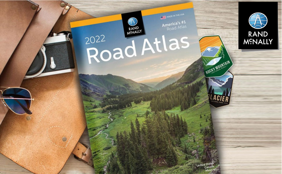
With the iconic Road Atlas leading the way, Rand McNally products have helped travelers make the most of their road trips for more than 100 years. The line of atlases, wall maps, travel guides, activity books, and other publications are developed to inspire an interest in the world and enrich life’s journey.

2022 Road Atlas Includes:
- Colorful, easy to read maps
- Shading highlights urban areas and parks and forests
- Shields for roads like Historic Route 66
- Interstate exit numbers, points-of-interest labels, and bingo keys
- Metro area insets, regional mileage charts, and local info
|
|
|
|
|---|---|---|
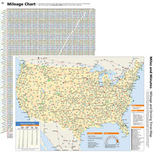
Maps
|
Mileage Chart & Driving Times
|
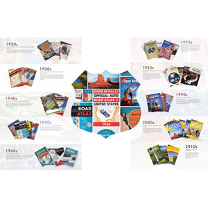
Rand McNally Road Atlas RetrospectiveTake a look back, from the beginning, at some of the covers that helped define the times. Starting with the original 1924 atlas to the iconic Rand McNally Road Atlas of today, the covers have been a reflection of society and travel. |
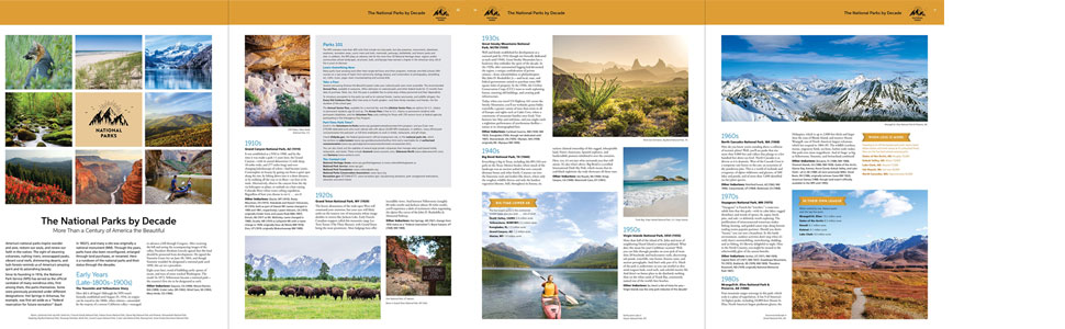
The National Parks by Decade
A review of park history that begins more than a century ago, with the first wild and wonderful place to achieve park status—Yellowstone.

|

|

|

|

|

|
|
|---|---|---|---|---|---|---|
| 2022 Road Atlas | 2022 Road Atlas w/ Vinyl Cover | Large Scale Road Atlas | National Parks Atlas & Guide | EasyFinder Midsize Road Atlas | Midsize Road Atlas | |
|
|
||||||
| Customer Reviews |
7,951
|
7,951
|
15,779
|
3,437
|
2,511
|
778
|
| Price | $19.11 | — | $38.93 | $29.30 | $28.90 | $14.42 |
| Maps of every U.S. state including mileage chart and mileage map showing distances | ✓ | ✓ | ✓ | ✓ | ✓ | ✓ |
| National parks info and travel tips | ✓ | ✓ | ✓ | ✓ | ✓ | |
| Road construction and conditions contact information | ✓ | ✓ | ✓ | ✓ | ✓ | |
| Tourism contact information | ✓ | ✓ | ✓ | ✓ | ✓ | |
| Index of cities and places | ✓ | ✓ | ✓ | ✓ | ✓ | |
| Maps of all Canadian provinces and overview of Mexico | ✓ | ✓ | ✓ | ✓ | ||
| Number of detailed city and national park maps | 375+ | 375+ | 350+ | 375+ | 50+ | 50+ |
| Tough spiral binding allows easier viewing | ✓ | ✓ | ✓ | |||
| 35% larger maps than standard versions | ✓ | ✓ | ||||
| Description | Contains maps of every U.S. state and Canadian province, an overview map of Mexico, and detailed inset maps of over 350 cities and 20 U.S. national parks. | Durable see-through vinyl cover gives added protection against constant use. | Give road-weary eyes a break with this spiral-bound Large Scale edition featuring all the accuracy you’ve come to expect from Rand McNally, with 35% larger maps. | 132-page National Park Guide, covering all 63 parks, is packed with hundreds of photos and essential visitor information. Includes a completely updated, 140-page Rand McNally Road Atlas. | This spiral-bound midsized atlas contains maps that are 35% larger than those in the regular Midsize Road Atlas. | Trusted, popular atlas in a convenient, 8" X 10 3⁄4" size. |
About the author
Follow authors to get new release updates, plus improved recommendations.

Reviews with images
Nice atlas, the "standard" updated
I agree with the other reviewers. This is everything that a nice American road atlas for use at home or in the car should be. It is helpful at times to see the big picture instead of the Google Maps version. For those who order the one with vinyl cover, just wanted to clarify. I wasn't sure if I was ordering the standard atlas but with a vinyl plastic cover or the standard atlas inside a plastic slip cover; it is the latter. See photo. It is like a well-fitting book cover over the standard paper product. My one minor disappointment was Amazon shipping. They put in inside a large flat box and the corner was bent in shipping. Again see photo. Since I am giving as a gift it would have been nice for it to be in mint condition.By the way, the atlas begins with an enjoyable summary overview and history or our National Parks.
Top reviews from the United States
There was a problem filtering reviews right now. Please try again later.
Reviewed in the United States on November 21, 2021


I agree with the other reviewers. This is everything that a nice American road atlas for use at home or in the car should be. It is helpful at times to see the big picture instead of the Google Maps version. For those who order the one with vinyl cover, just wanted to clarify. I wasn't sure if I was ordering the standard atlas but with a vinyl plastic cover or the standard atlas inside a plastic slip cover; it is the latter. See photo. It is like a well-fitting book cover over the standard paper product. My one minor disappointment was Amazon shipping. They put in inside a large flat box and the corner was bent in shipping. Again see photo. Since I am giving as a gift it would have been nice for it to be in mint condition.
By the way, the atlas begins with an enjoyable summary overview and history or our National Parks.
By the way, the atlas begins with an enjoyable summary overview and history or our National Parks.
Images in this review

Reviewed in the United States on April 24, 2022
Reviewed in the United States on June 1, 2021

Reviewed in the United States on January 9, 2022
Top reviews from other countries


John S. McDonald
Wouldn't be without one.
Reviewed in the United Kingdom on October 25, 2021