- India
- International
Wednesday, May 22, 2024
Journalism of Courage
 The Northeast was 'invented' via a series of ad hoc decisions aimed at governing the erstwhile frontier region. (Ministry of Home Affairs)
On December 30, 1971, two laws — the North-Eastern Areas (Reorganisation) Act and the North-Eastern Council Act — were enacted by Parliament.
With these, Northeast India “emerged as a significant administrative concept replacing the hitherto more familiar unit of public imagination, Assam,” B P Singh, a former senior bureaucrat who served as the Governor of Sikkim from 2008-13, wrote in The Problem of Change: A Study of North-East India (1997).
Today, ‘Northeast India’, or just ‘the Northeast’, is commonly used by Indians to refer to the diverse region, with its inhabitants becoming ‘Northeasterners’, regardless of how they themselves self-identify. Yet the term took root only in the 1970s.
Here is the story of the ‘invention’ of Northeast India.
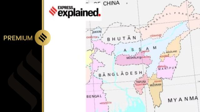
Northeast India officially comprises eights states — Arunachal Pradesh, Assam, Manipur, Meghalaya, Mizoram, Nagaland, Sikkim, and Tripura — which are a part of the North-Eastern Council, a statutory advisory body that plays a role in development planning, and region-level policy making.

Pre-Independence, five of these eight present-day states (Arunachal Pradesh, Assam, Meghalaya, Nagaland, Mizoram) were a part of colonial Assam. Manipur and Tripura were princely states, with resident British political officers answering to the governor of Assam.
Sikkim, the most unique of the eight, was juridically independent but under British paramountcy. It became an independent country in 1947, before being annexed by India in 1975. In 2001 Sikkim was made a member of the North Eastern Council, and thus officially a part of the Northeast.
Colonial Assam was a “frontier province” in British India. Like the North West Frontier Province (Khyber Pakhtunkhwa in present-day Pakistan), the political legal setup in the province was very different from the rest of the country.
Direct rule was limited to territories behind the administrative border, known as the ‘settled districts’ of Assam (most of present-day Assam and Sylhet, now in Bangladesh). These densely populated districts were — and still are — the region’s economic heartland, with thriving tea, coal, and oil industries emerging in the nineteenth century.
Beyond these districts lay the so-called ‘excluded areas’ or the ‘Hill areas’, controlled by various tribes, with minimal presence of the colonial state. These areas were (and still are, relatively speaking) sparsely populated, and provided a buffer zone between the ‘settled districts’ and the international border.
For instance, like the Federally Administered Tribal Area (FATA) located between the ‘settled districts’ of the NWFP and the international border with Afghanistan, the North East Frontier Tracts (modern-day Arunachal Pradesh and a part Nagaland) was carved out in 1914, and located between the ‘settled districts’ of Assam, and the international border with Tibet and Burma.
Thus, at the time of Independence, the region was unlike any other territory India inherited from the British. Northeast India, as an official place-name, is born out of the postcolonial Indian state’s attempts to turn this imperial frontier space into the national space of a “normal sovereign state.”
To do this, the Indian state made a series of ad hoc decisions to institute a new governance structure that eventually replaced the administrative setup of a colonial frontier province. Their foremost concern was the nebulous concept of national security.
After 1947, 98 per cent of the region’s borders became international (with China, Myanmar, Bangladesh, and Bhutan). A roughly 22 km wide land corridor in Siliguri, often referred to as the “chicken’s neck”, became its sole physical connection with the rest of India.
By the 1960s, national security concerns were further heightened. India lost a border war with China in 1962, with the Chinese entering all the way into Assam, and the movement for Naga independence was in full swing. India and Pakistan fought a war in 1965, and the Mizo rebellion began the following year. Fears about the challenge to national security if the country’s external and domestic enemies were to join hands, became jarringly immediate.
That the state of Nagaland was created a year after the China War is no accident. By making Nagaland into a state, Indian officials hoped to create Naga stakeholders in the Indian dispensation that would help quell the Angami Zapu Phizo-led rebellion. In retrospect it turned out to be the first step toward replacing the administrative structure of the frontier province with a new structure of governance.
With the North-Eastern Areas (Reorganisation) Act of 1971, Manipur and Tripura, previously union territories, were given statehood. Meghalaya was carved out of two previously autonomous districts within Assam, and so was the union territory of Mizoram. The erstwhile North East Frontier Agency became the union territory of Arunachal Pradesh. Both Mizoram and Arunachal would be granted full statehood in 1987.
When using a directional name, it is perhaps always a good idea to ask, “Where is it we really start from, where is the place that enunciates this itinerary”? For “the Northeast”, the point of reference is clear: it is the Indian “heartland”. The directional place-name highlights the peculiar hierarchical relation that has developed between this region and the nation since Independence.
There is perhaps no better evidence of the region’s othering than the normalisation of the racialized category Northeasterner. While the term is hardly ever used for self-identification (one rarely hears someone say “I am a Northeasterner” rather than “I am a Naga/Khasi/Meitei/Kuki”), it nonetheless has found its way into commonspeak, especially outside the region.
Moreover, Northeasterners have long complained of being subjected to racial slurs based on phenotypic stereotypes. Many find themselves non-recognized and misrecognized, hailing from places such as China, Nepal, Thailand, or Japan, or as ‘lesser Indians’ rather than as equal citizens.
Since the new governance structure and its naming were the result of a process of muddling through — and not much thought was given to its possible consequences — it was perhaps inevitable that it would create as many new problems as it would solve.
Sanjib Baruah is the Andy Matsui Distinguished Professor of the Humanities at the Asian University for Women in Chattogram, Bangladesh. He authored ‘In the Name of the Nation: India and its Northeast’ in 2020.

OpenAI’s GPT-4o has some insane capabilities: 7 use casesSubscriber Only
All We Imagine As Light: How to make it toSubscriber Only

UPSC Key | India's climate policy, Green Credit Program andSubscriber Only
What the upswing in J-K voter turnout could mean forSubscriber Only
Former WHO chief scientist at Idea ExchangeSubscriber Only

The history of SC orders against illegal mining in SariskaSubscriber Only

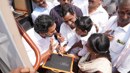
Bollywood superstar Shah Rukh Khan was hospitalized in Ahmedabad due to a heatstroke while attending an IPL match between Kolkata Knight Riders and Sunrisers Hyderabad with his children and other actors. He was later seen celebrating his team's victory and accidentally interrupted a post-match show, but quickly apologized. Fans and media await further updates on his condition.