
Abstract
The September 19, 1985 M8.1 earthquake west of Michoacán, Mexico, due to shallow subduction of Cocos plate beneath the North American plate. This mega-thrust inverse faulting event broke about 200 km along the boundary of the Mexican subduction zone in the Pacific coast of Michoacán. This earthquake consisted of two main sub-events at 16 km depth, separated 27s in time and about 95 km SE in distance. Thirty-six hours later, a major M7.5 aftershock occurred in the SE edge of the same area. The 1985 earthquake caused enormous damages, even at distances of up to 300 km from the epicenter. This was the case of Mexico City in which the maximum accelerations recorded reached 0.17 g, exceeding building codes limits (Anderson et al. in Science 233:1043–1049, 1986), and spectral amplifications and duration were unprecedented (Singh et al. in Bull Seism Soc Am 78:451–477, 1988). The official account reported more than six thousand buildings destroyed or seriously damaged and estimated between 10,000 and 35,000 persons missing or dead. After this earthquake, seismic monitoring systems have been developed and improved. The building codes are often revised and regular monitoring of structures is currently done after earthquakes to keep safer standards. In the same vein, a number of educational programs were developed to promote a culture of prevention. It is claimed that the 1985 earthquake generated a widespread solidarity and awareness among city dwellers. On September 19th, 2017, an intraplate earthquake M7.1, hit Central Mexico again, causing extensive building damage, testing the effectiveness of developed programs implemented after the 1985 earthquake.
Keywords
1 Introduction
A significant part of Mexican territory is shaken by earthquakes of different types engendered by the tectonic activity of the region. The Cocos and the North American plates at the Mexican subduction zone have a convergence rate of about 5 cm/year. This motion induces intraplate earthquakes (M ≤ 7) on the North American plate, intermediate normal fault events on Cocos Plate (M ~ 6) and large subduction earthquakes (M > 8). However, the distribution of intensities and effects of these earthquakes differ. Among the most important subduction events occurred in twentieth century we count:
-
The M7.6 earthquake of June 7, 1911 with a rupture area of ca. 60% the one of the 1985 earthquake (UNAM Seismology Group GRL 1986)
-
The M7.8 earthquake of July 28, 1957
-
The M7.4 Petatlan event of March 14, 1979 which ruptured essentially at the zone of the 1985 major aftershock
-
The M7.3 Playa Azul shock that occurred in October 25, 1981 with a rupture area of about 40 × 20 km2 (Havskov et al. 1983) (Fig. 1).
Fig. 1 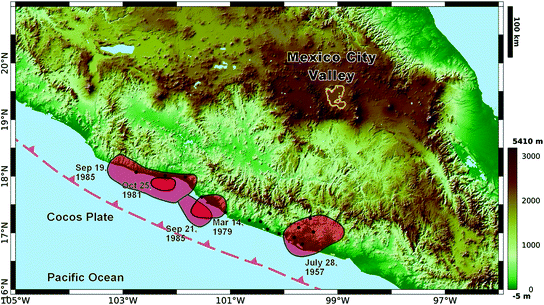
Elevation map of central Mexico. Mexico City Valley is delineated with a yellow line in the middle of Trans Mexican Volcanic Belt. The estimated ruptures of five subduction events are shaded with red (from left to right: 09.19.85 M8.1; 10.25.81 M7.3; 09.21.85 M7.5; 03.14.79 M7.4; 07.28.57 M7.8). The dashed red line indicates the trench of Cocos and North American plates and the accelerometric stations of Guerrero Array are plotted with black dots

These earthquakes caused minor damage in Mexico City, which is roughly 300 km away from the subduction zone, in comparison with the damage caused by the 1985 earthquake.
Nowadays, although the 1957 and 1979 earthquakes could be seen as a kind of warnings because of conspicuous collapse of some buildings in Mexico City, the lack of reliable historical seismicity data led to minimize the seismic hazard, and therefore effects and intensity of the 1985 earthquakes could not be anticipated. Moreover, the occurrence of such events is considered rare and the systematic recording of earthquakes is relatively recent (Sánchez-Sesma and Crouse 2014). Regarding the 1985 Michoacan Earthquake, it exists a vast bibliography. Among them are the three special issues in Earthquake Spectra (1988, 1989). In this paper, a brief account of some relevant seismological facts and important actions taken as a consequence of the 1985 earthquake and its effects on Mexico City are highlighted. This may have some bearing on the reconstruction issues at the aftermath of the April 25, 2014 Nepal earthquake.
2 Geology Frame
The Mexico City Valley geological characteristics are unique. Mexico City is in a plateau at 2250 m.a.s.l., and covers a region of about 110 km N–S and 80 km E–W. Quaternary and Cenozoic volcanoes surround the Valley, and shallow lakes (Xaltocan, Zumpango, Texcoco, Xochimilco and Chalco) formed after the Pleistocene-Holocene Chichinautzin mountain range closed the Basin resulting in the formation of the lacustrine system on which the Mexico City is extended (Fig. 2) (Mooser et al. 1974; Padilla y Sánchez 1989). The City was founded in the fourteenth century and since then floodings were not rare. In the Prehispanic Aztec towns hydraulic control structures like channels and dikes proliferate. The Chinampas (kind of floating terrains that eventually became cultivated areas) were also common constructive systems. Since the sixteenth century, with the Spanish Colonization, the lakes started to be drained to avoid the recurrent floodings. Thereby, the City grew within a basin on loose layers of compound soil of clay, sand and volcanics, over the Mesozoic bedrock of marine sedimentary sequence.

Elevation map of Mexico City Valley and the mountain ranges that closed the basin: “Sierra de Las Cruces”, “Sierra Chichinautzin” and “Sierra Nevada”. Inside the basin is the Lake Zone characterized by soft lacustrine soils, shaded in dark gray. The Transition Zone is plotted in light gray and the Hill Zone (above 2300 masl) in green. The red dots indicate stations of the Accelerometric Network that operates since 1987 to the present. The yellow triangles denote accelerometer stations that recorded the 1985 earthquakes
The geology conditions of the region constrain the soil characteristics and determine the seismic response of Valley. Mexican engineers knew the peculiar soil conditions of the City and the special requirements were generated for the design of foundations and structures since the early 50s. Marsal and Mazari (1959) classified the soils of Mexico City in the three geotechnical zones depicted in Fig. 2. The Hill Zone, known also as the hard soil, extends on the higher elevations in the Valley, it is composed of lava flows and volcanic tuffs. The transition Zone presents alluvial sandy and silty layers with occasional intervals of clay, and surrounds with some volcanic craters. The Lake Zone, occupies the central area of the Basin, characterized by lacustrine soft-bed soil composed by highly compressible deposits with 20–80 m thickness over resistant sands.
This geotechnical classification has been useful to establish the building code regulations generated after the careful study of the recorded ground motion before and after 1985. However, this layered classification cannot explain alone the large amplitudes and long durations recorded at sites of the Valley during the Michoacan Earthquake. It is now generally accepted that to forecast the response of the Valley, a complete layered model should take into account the concatenation of source, path and site effects (e.g. Singh et al. 1988; Sánchez-Sesma et al. 1988; Campillo et al. 1989; Castro et al. 1990).
On the other hand, the water supply to the city has been an issue of major concern. Aqueducts provided water but since the mid-nineteenth century, wells were installed to extract the liquid from the aquifers (between the clay formations or below them). With time, the extreme exploitation of the aquifers produces subsidence and the ensuing changes of dominant period of the ground at some sites (Ovando-Shelley et al. 2007). All these effects combined make the Valley of Mexico highly vulnerable to the seismic threat despite of its long distance to the Pacific trench.
3 The 1985 Earthquake Characteristics
Since early 1985, seismologists were waiting for a big quake at the so called Guerrero Gap and a series of accelerometric recording stations have been installed along the Mexican Pacific coast in the Guerrero Array. In fact, the 19 September earthquake occurred in the Michoacán seismic gap, which had been identified as a zone with high seismic potential and was well recorded by the array. This mega-thrust earthquake was caused by subduction of the Cocos Plate beneath Mexico (Fig. 1). The station at Caleta de Campos was just above the epicenter (Anderson et al. 1986). On September 19, 1985, at 07:18 h (local time), a M8 earthquake of occurred with epicenter close to Pacific coast of Mexico, with some damage in the epicentral area and Ciudad Guzman, Jalisco. However, the damages in Mexico City were unprecedented.
The fault rupture area was of about 200 km length along the boundary of the Mexican subduction zone in the Pacific coast of Michoacán and a width of about 50 km. The thrust source mechanism had a 288° fault plane strike and a dip of 9° (Eissler et al. 1986). Strong ground motion investigations indicate that this major earthquake consisted of two main sub-events at 16 km depth, separated 27 s in time and about 95 km SE in distance (Fig. 1). The larger M7.5 aftershock occurred thirty-six hours later, in the SE edge of the same area. The total seismic moment was of about 11 × 1028 dyne-cm (Astiz et al. 1987) and the rupture area was of about 104 km2 (see Fig. 1).
4 Effects of Soil Amplification and Structural Damage
The 1985 earthquake produced large intensities in Mexico City, in the Mercalli scale they reached level IX. Maximum accelerations reached 0.17 g, thus exceeding building codes limits (Anderson et al. 1986) and the spectral amplifications and durations were unprecedented (Singh et al. 1988). These features are quite unusual for an event which epicentral distance to the site is of about 400 km. The earthquake destroyed or severely damaged about six thousand buildings. The causalities are estimated to be between 10,000 and 35,000 people with tens of thousands injured or homeless. The cost of damages has been estimated to be larger than the 2% of the gross domestic product in 1985.
The influence of soft soil on the seismic response of alluvial valleys may produce significant amplifications of the ground motion. This problem has been the subject of numerous studies (e.g. Bard and Bouchon 1980a, b; Sánchez-Sesma 1987; Aki 1988; Kawase and Aki 1989; Campillo et al. 1989). The large amplitude ground motion and long duration records in the lacustrine plain sites in the Valley of Mexico result from the combination of significant source, path and site effects (e.g. Singh et al. 1988; Sánchez-Sesma et al. 1988; Campillo et al. 1989; Castro et al. 1990). Ordaz and Singh (1992) discovered a large regional amplification. They demonstrated, using a data set of seismograms from stations located both inland and along the cost, that seismic waves at hill zone sites in Mexico City are amplified. Such amplifications at the so called “hard zone” are remarkable as they reach at least 10 times at critical frequencies for Mexico City soil conditions (1–5s). Considering that the uppermost soft layers trap the seismic wave energy causing significant ground motion amplifications, reaching 10–50 times, in lake-bed sites with respect to the hill sites at periods between 1 and 5 s. This results in an amplification of 100–500 with respect to the hard sites with similar hypocentral distances, located inland or along the coast. Moreover, their study shows that the amplification effects and damages seem to be independent from the earthquake magnitude. These observations strongly suggest that amplification effects in Mexico City are not only due to the lacustrine soil characteristics. The mechanisms are still to be elucidated as amplifications that are beyond the levels predicted by simple 1D models (Sánchez-Sesma et al. 1988; Singh et al. 1998). All this brings on the validity of the term ‘site amplification’ to adequately explain the observed devastation.
In addition, the number of Pre-Hispanic structures (e.g. channels, tunnels, temples), under which have been built modern structures is unknown. Their condition may cause important effects in the seismic response during earthquakes. Padilla y Sánchez (1989) showed a link between more than 2000 collapsed and damaged buildings and Pre-Hispanic and Colonial structures, during the 1985 earthquake.
Many of the structural collapses were buildings that fulfilled the requirements of the Complementary Technical Standards (NTC) 1976 of the Building Regulations of the Federal District (effective in 1985). This was due to the large values of peak ground acceleration in the Lake Zone (Fig. 2) as compared to the expected values. Ductility factors (Q) was allowed to reach 6, which further decreased the design acceleration.
On the other hand, the duration of ground motion imposes critical conditions to structural response. Based on recorded data Reinoso and Ordaz (2001) proposed expressions to estimate duration in Mexico City in terms of magnitude distance and the dominant period of site. In some sites the duration of strong ground motion in 1985 exceeded 5 min., particularly in the lakebed zone (Fig. 2). This subjected the structures to lasting oscillations, which in some cases may had caused resonance and/or structural failure due to the loss of strength after many cycles of load (Ordaz and Singh 1992). The slab punching by columns revealed lack of shear reinforcement and many systems, particularly reinforced concrete structures, but also those of steel, showed lack of strength and ductility when their periods were close to the site period.
5 New Building Code Regulations
Besides source, paths of seismic waves and the geological and subsoil conditions, irregular settlements in difficult soil conditions and poor enforcement of building regulations contributed to the collapse or failure of hundreds of structures. After the 1985 earthquake, the building codes are often revised and regular monitoring of structures is done after earthquakes to keep safer standards.
Several studies helped to characterize in detail the Mexico City subsoil; results from geotechnical and geophysical prospecting campaigns updated the shallow structure model in some areas inside the Mexico City Valley (Auvinet and Juárez 2011). Imaging investigations for subsidence monitoring and for ground water extraction are taken into account for improving the design of foundations and underground structures (Cabral et al. 2008).
Relying upon the acceleration records at many points in the City an empirical model was developed to evaluate site effects and the response of the Valley (Ordaz et al. 1994). First attempts regarding on spectral ratios were calculated with respect to a reference station at the Hill Zone (CU at UNAM’s main campus). Spectral ratios showed remarkable stability for most events, regardless their origin, their source mechanism and their magnitude (Rosenblueth and Arciniega 1992; Arciniega-Ceballos 1990). Applying some averaging techniques and interpolation scheme (Pérez-Rocha 1998) the representative spectral ratio of at each point was obtained. Then, assuming smooth spatial variation of the dominant period and applying random vibration theory (Boore 1983) the response spectra was estimated at any point within the accelerometric array.
Regarding the dominant periods of soil sites, it has recently been discovered that the frequency characteristics of the sites change with time. For instance, the site SCT had 2.0s in 1985 and now is 1.6s (Avilés and Pérez-Rocha 2010). These might be attributed to several factors that alter the soils conditions and their elastic properties (Ovando-Shelley et al. 2007). For those construction systems that are vulnerable to long lasting resonant ground motion, the emergency regulations (released just after the 1985 earthquake and the subsequent versions), included increases in steel reinforcement, like stirrups and joints. Significant strength requirements, regarding sections of columns, walls and beams, were introduced. That leads to increases in stiffness as well. Systems with rigid flat-slabs and frames without walls have now stronger requirements in both strength and ductility. Moreover, slenderness and irregular geometries were restricted. They are however not free of controversy as they leave to designers some freedom to choose, as some simplifications require higher coefficients, while more costly and detailed procedures allow weaker constrains. These specifications and other design parameters have been modified in the 1993 and 2004 versions that are currently used where the seismic coefficient of maximum design acceleration is 0.45 g.
6 Accelerometric Network, Alert System and Institutional Outreach
In 1985 the Mexico City Accelerometric Network (MCAN) had only 9 stations (marked with stars in Fig. 2). Few years after the earthquake, the monitoring systems improved increasing the MCAN around 80 in the free field (Fig. 2). Nowadays the MCAN resulted from joint efforts of collaboration between the Institutes of Engineering and Geophysics, UNAM and Centro de Instrumentación y Registro Sísmico (CIRES—a private non-profit organization). In addition, around the Valley there are 31 short-period seismometers, operated by the National Seismic Survey, which nowadays counts with a network of 56 broadband STS-2 and 9 short-period seismometers distributed around the country (see http://www.ssn.unam.mx/acerca-de/estaciones/).
A Seismic Alarm System for Mexico City, developed by CIRES, was implemented for earthquakes with magnitudes larger than M6 occurring along the Guerrero and Michoacán coast. This system gives about 50-s warning before the shear waves arrive to the Valley.
In 1988, the National Disaster Prevention Center was established; first, sponsored by the Japanese International Cooperation Agency and later by the Mexican Ministry of Interior. In the last few years an independent organism was created: The Institute for Building Safety which aim is to promote criteria to enforce the fulfillment of code requirements. This requires close collaboration with professional engineering organizations. The widespread damage after the 1985 quake, was enormous and the nature of the causes, initially was a mystery for most of the population, therefore a number of educational actions were developed to promote the culture of prevention: regular simulacrums, insurance information, formation of well-trained emergency search and rescue brigades, are all among the preventive measures adopted.
7 Conclusions
The Valley of Mexico grew on loose layers of compound soil of clay, sand and volcanics. The unconsolidated thick layers of lake sediments (circa 100 m), together with the excess draining of the aquifer, subject the City to severe processes of subsidence. These local characteristics in addition with tectonic and regional settings favor the amplification of seismic waves and long lasting codas.
It is well known that earthquakes cannot be predicted and it is as well difficult to anticipate their intensities. Specially, in the case of complex earthquakes like Michoacán 1985 and Tohoku 2011. These types of events are considered rare and our knowledge about such earthquakes is still limited regarding that the necessary dense seismic networks are relatively recent.
The study of the 1985 Michoacán earthquake and its effects in Mexico City brought on new impetus and several studies have served as an example to the world contributing to our understanding on the seismic response in basins with lacustrine and sand conditions (e.g. San Francisco Bay, CA in 1989). More recent investigations include analyses and modeling of site effects, mechanical and geometrical characteristics of the strata and subsoil and the damage distribution caused by a strong-motion event (Baena et al. 2016 and references here in).
In the same vein, the recently created Institute for Building Safety by the City government may contribute to guarantee structural safety by rigorous code enforcement. The maximum design acceleration were increased, the values of the ductility factor (Q) for different types of structures and building materials were restricted, and increases the steel reinforcement. All these actions are established to implement practical criteria for the adequate assessment of future ground motion levels and seismic risk mitigation. Nevertheless, more efforts have to be done to create awareness among public, architects, engineers planners and policy makers about the implications on living in a region with high rates of seismicity.
8 Addendum
The effectiveness of the developed programs was tested exactly 32 years after the M8.1 1985 Michoacán event by the occurrence of two intraplate earthquakes: the first, M8.2, on September 7th, 2017, in Tehuantepec, at a distance of about 600 km to Mexico City, and the second, M7.1, ironically again on September 19th, between Puebla and Morelos States, only 120 km away from Mexico City. Both events had an extensional mechanism and about the same depth of 57 km, causing considerable damage within a radius of approximately 200 km. During the M8.2 earthquake, maximum accelerations (Amax) did not exceed the values recorded in 1985, causing almost no damage in Mexico City, while during the M7.1 earthquake, Amax in hard zone (57 cm/s2), doubled the response recorded in 1985 (30 cm/s2). Damage not only happened in the soft-lake zone, also many buildings (3 to 8 floors) collapsed in the transition zone. This might be attributed to the high frequency content of the almost vertically incoming waves motion.
It is clear that this recent seismic activity put to the test the programs implemented after 1985. Building codes for different earthquakes scenarios have to be revised as well as the strict supervision of regulations by qualified and uncorrupted authorities.
The Seismic Alert System (SAS) worked during the M8.2 quake as expected but during the M7.1 event the SAS triggered late. This happened because SAS is designed for earthquakes coming from the Pacific coast. Fortunately, the M7.1 earthquake took place 2:15 hours after the annual simulacrum exercise, mitigating considerably the casualties (about 500 nationwide) compared with about 10,000 casualties of the 1985 Michoacán earthquake. This experience states the urgent revision of civil protection programs, in order to strengthen education and routinely practice simulacrum exercises. In addition, a nationwide coverage of the warning system should be achieved.
References
Aki K (1988) Local site effects on strong ground motion. In: Von Thun JL (ed) Earthquake engineering and soil dynamics II: recent advances in ground motion evaluation, Geotechnical Special Publication Am Soc Civil Eng, New York, 20:103–155
Anderson JG, Bodin P, Brune JN, Prince J, Singh SK, Quass R, Onate M (1986) Strong Ground Motion from the Michoacan, Mexico Earthquake. Science 233:1043–1049
Arciniega-Ceballos A (1990) Modelo semi-empírico para estimar espectros de respuesta sísmicos en el valle de México. Thesis, National Autonomous University of Mexico
Astiz L, Kanamori H, Eissler H (1987) Source characteristics of earthquakes in the Michoacan Seismic gap in Mexico. Bull Seism Soc Am 77:1326–1346
Auvinet G, Juárez M (2011) Geotechnical characterization of Mexico City subsoil. In: Proceedings of the 14th Pan-American conference on soil mechanics and geotechnical engineering http://geoserver.ing.puc.cl/info/conferences/PanAm2011/panam2011/pdfs/GEO11Paper1204.pdf
Avilés J, Pérez-Rocha LE (2010) Regional subsidence of Mexico City and its effects on seismic response. Soil Dyn Earthq Eng 30(10):981–989
Baena-Rivera M, Perton M, Sánchez-Sesma FJ (2016) Surface-wave retrieval from generalized diffuse fields in 2D synthetic models of alluvial valleys. Bull Seism Soc Am 106(6):2811–2816. doi:10.1785/0120160084
Bard PY, Bouchon M (1980a) The seismic response of sediment filled valleys. Part 1: the case of incident SH waves. Bull Seism Soc Am 70:1263–1286
Bard PY, Bouchon M (1980b) The seismic response of sediment filled valleys. Part 2: the case of incident P and SV waves. Bull Seism Soc Am 70:1921–1941
Boore D (1983) Stochastic simulation of high-frequency ground motions based on seismological models of the radiated spectra. Bull Seism Soc Am 73(6):1865–1894
Cabral-Cano E, Dixon TH, Mirelles-Wilhelm F, Sánchez-Zamora O, Diaz-Molina O, Carande R (2008) Space geodetic imaging of rapid ground subsidence in Mexico City. Bull Geol Soc Am 120(11/12):1556–1566. doi:10.1130/B26001.1
Campillo M, Bard BY, Nicollin F, Sánchez-Sesma FJ (1988) The Mexico earthquake of September 19, 1985. The incident wave field in Mexico City during the great Michoacan earthquake and its interaction with deep basin. Earthq Spectra 4:591–608
Campillo M, Gariel JC, Aki K, Sánchez-Sesma FJ (1989) Destructive strong ground motion in Mexico City: source, path and site effects during the great 1985 Michoacán earthquake. Bull Seism Soc Am 79:1718–1735
Castro R, Anderson JG, Singh SK (1990) Site response, attenuation and source spectra of S waves along the Guerrero, Mexico, subduction zone. Bull Seism Soc Am 80(6A):1481–1503
Eissler HL, Astiz S, Kanamori H (1986) Tectonic settings and source parameters of the September 1985 Michoacan, Mexico, earthquake. Geophys Res Lett 13:569–572
Havskov J, Singh SK, Nava E, Domínguez T, Rodriguez M (1983) Playa Azul, Michoacan, Mexico, earthquake of 25 October, 1981 (Ms = 7.3). Bull Seism Soc Am 73:449–458
Kawase H, Aki K (1989) A study on the response of a soft basin for incident S, P, and Rayleigh waves with special reference to the long duration observed in Mexico City. Bull Seism Soc Am 79:1361–1382
Marsal RJ, Mazari, M (1959) El subsuelo de la Ciudad de México. Instituto de Ingeniería. Universidad Nacional Autónoma de México
Mooser F, Nairn AEM, Negendank JFW (1974) Palaeomagnetic investigations of the tertiary and quaternary igneous rocks: VIII a palaeomagnetic and petrologic study of volcanics of the Valley of Mexico. Geol Rundsch 63(2):451–483
Ordaz M, Singh SK (1992) Source spectra and spectral attenuation of seismic waves from Mexican earthquakes, and evidence of amplification in the hill zone of Mexico City. Bull Seism Soc Am 82:24–43
Ordaz M, Singh SK, Arciniega-Ceballos A (1994) Bayesian attenuation regressions: an application to Mexico City. Geophys J Int 117:335–344
Ovando-Shelley E, Ossa A, Romo MP (2007) The sinking of Mexico City: its effects on soil properties and seismic response. Soil Dynamics and Earthquake Engineering 27:333–343
Padilla y Sánchez RJ (1989) Geology and tectonics of the basin of Mexico and their relationship with the damage caused by the earthquakes of september 1985. Int J Min Geol Eng 7(1):17–28
Pérez-Rocha LE (1998) Respuesta Sísmica Estructural: Efectos de Sitio e Interacción Suelo-Estructura (aplicaciones al Valle de México). Ph.D. thesis School of Engineering Universidad Nacional Autónoma de México, Mexico
Reinoso E, Ordaz M (2001) Duration of strong ground motion during Mexican earthquakes in terms of magnitude, distance to the rupture area and dominant site period. Earthq Eng Struct Dynam 30:653–673
Rosenblueth E, Arciniega A (1992) Response spectral ratios. Earthq Eng Struct Dys 21:483–492
Sanchez-Sesma FJ (1987) Site effects on strong ground motion. Soil Dyn Earthq Eng 6:124–132
Sánchez-Sesma FJ, Chávez-Pérez S, Suárez M, Bravo MA, Pérez-Rocha LE (1988) The Mexico earthquake of september 19, 1985: on the seismic response of the Valley of Mexico. Earthq Spectra 4:569–589
Sánchez-Sesma FJ, Crouse CB (2014) Effects of site geology on seismic ground motion: early history. Earthq Eng Struct Dyn. doi:10.1002/eqe.2503 (published online in Wiley Online Library)
Singh SK, Mena E, Castro R (1988) Some aspects of the source characteristics and the ground amplifications in and near Mexico City from the acceleration data of september 1985 Michoacan Earthquake. Bull Seism Soc Am 78:451–477
Singh SK, Lermo J, Dominguez T, Ordaz M, Espinosa JM, Mena E, Quaas R (1998) The Mexico earthquake of september 1985 a study of seismic waves in the Valley of Mexico with respect to a hill zone site. Earthq Spectra 4:653–673
UNAM Seismology Group (1986) The September 1985 Michoacan earthquakes: aftershock distribution and history of rupture. Geophys Res Lett 13:573–576
Acknowledgements
Thanks are given to Roberto Meli and Mario Rodriguez for their comments and suggestions. Ana L Ruiz provided some station coordinates. The help of Elizabeth Plata and Guillermina Sánchez and their team of USI-II UNAM was useful to locate references. This work was partially supported by AXA Research Fund, by DGAPA-UNAM, Grants Numbers IN104712, IN106111, IN105716, and by CONACYT 101515.
Author information
Authors and Affiliations
Corresponding author
Editor information
Editors and Affiliations
Rights and permissions
Copyright information
© 2018 Springer International Publishing AG
About this paper

Cite this paper
Arciniega-Ceballos, A., Baena-Rivera, M., Sánchez-Sesma, F.J. (2018). The 1985 (M8.1) Michoacán Earthquake and Its Effects in Mexico City. In: Kruhl, J., Adhikari, R., Dorka, U. (eds) Living Under the Threat of Earthquakes. Springer Natural Hazards. Springer, Cham. https://doi.org/10.1007/978-3-319-68044-6_4
Download citation
DOI: https://doi.org/10.1007/978-3-319-68044-6_4
Published:
Publisher Name: Springer, Cham
Print ISBN: 978-3-319-68043-9
Online ISBN: 978-3-319-68044-6
eBook Packages: Earth and Environmental ScienceEarth and Environmental Science (R0)