
 Home
Home  Membership
  TwinklCares
  Create
  Blog
Blog 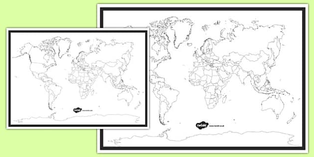
Blank World Map
How can I use this printable blank world map?
This printable blank world map can be used in lots of different ways from Pre-K through elementary or even for homeschooling.
Related Searches
 world map with countries
map of the world
blank world map
map of the world with countries
continents
blank world map with countries
map of europe
mexico
world map with countries labelled
map or byd
map y byd
europe map
map of asia
world map blank
countries and nationalities
travelling around
maps
countries and continents
world map with countries
map of the world
blank world map
map of the world with countries
continents
blank world map with countries
map of europe
mexico
world map with countries labelled
map or byd
map y byd
europe map
map of asia
world map blank
countries and nationalities
travelling around
maps
countries and continents
- Ratings & Reviews
- Curriculum Links
- Make a Request
- Resource Updates
-
Great
-
Hello kfrost,
It's always lovely to hear that people like our resources. Thank you so much for taking the time to comment. 3 years ago
✔ Thank you for your feedback
-
-
Geography
-
Hello jayneholland ,
I'm glad you found this resource useful :) 4 years agoOne person found this helpful✔ Thank you for your feedback
-
-
For children to find the countries that Tim Peake has photographed from the I.S.S.
-
Hi SGibson22,
I'm so pleased you found this resource helpful! We really appreciate your feedback :)
You might also like this: https://www.twinkl.co.uk/resource/t2-s-786-new-tim-peake-british-astronaut-resource-pack
Let me know what you think!
 6 years agoOne person found this helpful✔ Thank you for your feedback
-
-
Brilliant for enabling children in Y6 to understand the full scope of WW2 as they see where the key figures and battles come in.
-
Hi kpechey.209,
It's always lovely to hear that people like our resources. Thank you so much for letting us know! :) 6 years agoOne person found this helpful✔ Thank you for your feedback
-
-
Used in conjunction with the 'Anywhere Island' Yr 6 project pack. Thank you
-
Hello alit90,
I'm really glad you're finding it useful! Thanks for sharing :) 4 years ago
✔ Thank you for your feedback
-
-
To start a mini topic on Indonesia.

-
Hi boxgirl,
I'm glad this resource is useful! Thanks for letting us know :) You might find this bunting handy too:
https://www.twinkl.co.uk/resource/t-t-27781-indonesia-flag-bunting 6 years ago
✔ Thank you for your feedback
-
- Twinkl added Editable Version 3 years ago
- Twinkl added continents 6 years ago
- Twinkl updated the Main Version 7 years ago
- Twinkl added 4xA3 Version 7 years ago
- Twinkl added Colour Background Version 8 years ago
- Twinkl added 2xA3 Version 8 years ago
- Twinkl added 2xA4 Version 8 years ago
- Twinkl added 4xA4 Version 8 years ago
- Twinkl added A3 Version 8 years ago
- Twinkl added A4 Version 8 years ago
How can I use this printable blank world map?
This printable blank world map can be used in lots of different ways from Pre-K through elementary or even for homeschooling.
Ready for you to download and print in a variety of PDF formats, this map is available in lots of different versions, including A3, A4 and even a huge 4xA3 version for you to use on a bulletin board. Just print the maps you need for a no-prep activity for any age group.
Showing major countries, continents and oceans of the world, students can practise labelling the globe without any clues whatsoever. You can use pencil crayons or markers to label and colour your printable blank world map.
This printable blank world map is ideal for checking your students' knowledge of the globe helps them to practise recalling all the information that they've come across in their geography lessons. You could even display this map on-screen in your classroom by using an overhead projector and point out countries for your students to name. They could then take notes on their printed copies.
Another idea is to ask your students to label as many countries as they can in a group or in pairs. As an extension task, you could put them to the test and ask them to add the locations of major cities or famous Canadian landmarks such as the CN Tower or Parliament Hill.
Maps can also be really useful for teaching social studies. You could chart historical battles and events, label provinces and territories or even use them to keep up with world news. During the holiday season, you could even use it to think about Christmas around the world.
If your family are keen travellers, why not get your child to colour in and name the countries they have been to or would like to visit?
More ideas to support your teaching on maps
Every teacher needs a printable blank world map to show their students the world and its continents, oceans and major countries in their geography lessons. This one is ideal for keeping in your stash of go-to resources.
But there's more to geography than the map of the world. Other resources that you may find useful for teaching about Canada and the wider world include:
- Canada's Provinces and Territories Colouring Page — a fourth-grade colouring activity for learning about geography closer to home.
- Canadian Cities Matching Worksheet — help children learn the capital cities of each province and territory.
- Five Oceans Labelling Map Worksheet — you've learnt the continents, now it's time to move on to the oceans. Use this sheet in class or as a homework activity.
- Continents of the World PowerPoint — learn the basics about continents with this no-prep, downloadable PowerPoint.
All of these resources have been created by our fantastic team of fully qualified teachers, providing you with peace of mind and top-quality resources for teaching geography for kids.
World geography facts
Now your printable blank world map is sorted, why not bring out a few world geography facts that will amaze your class?
- Mt. Thor on Baffin Island, Canada, has the greatest sheer vertical drop on Earth. If you stepped off the top, you would fall 4101 feet.
- 90% of people on Earth live in the Northern hemisphere.
- The population of California (approx. 39.5 million in 2019) is greater than the whole population of Canada put together (approx. 37.5 million in 2019).
- At their closest points, Russian and the US are only 2.4 miles apart.
- Vatican City is the smallest country in the world.
Take a look at the video below to learn even more about the globe.