Misc
Mapped: Visualizing the True Size of Africa

Mapped: The True Size of Africa
Take a look at any map, and it’s clear that the African continent is a big place.
However, despite the common perception that Africa is a large landmass, it’s still one that is vastly underestimated by most casual map viewers.
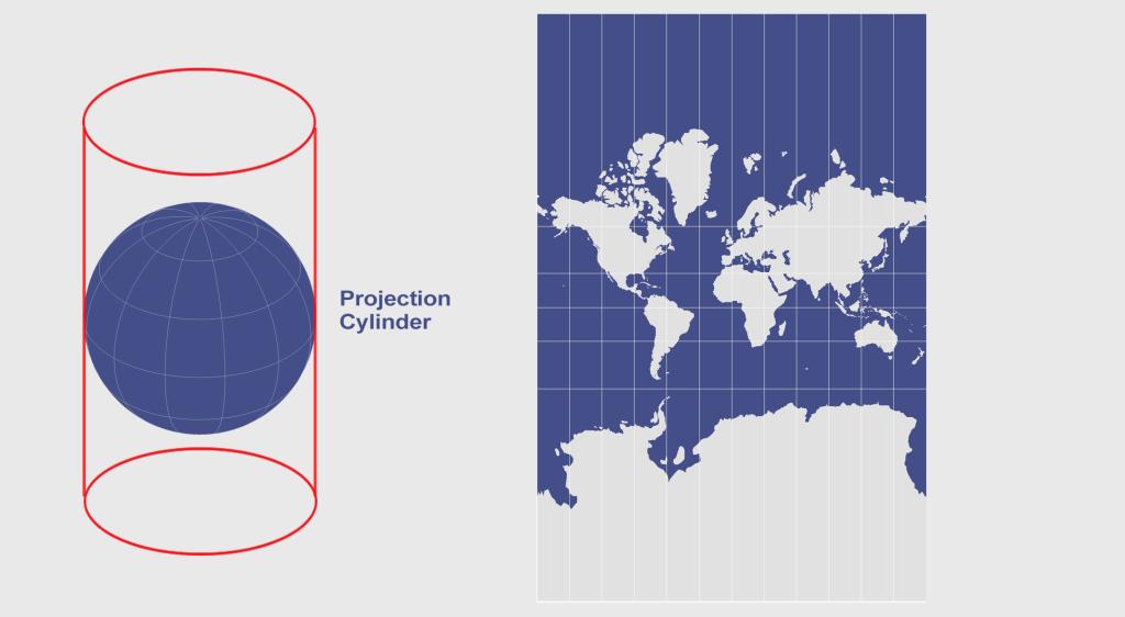
The reason for this is that the familiar Mercator map projection tends to distort our geographical view of the world in a crucial way — one that often leads to misconceptions about the relative sizes of both countries and continents.
A Geographical Jigsaw
Today’s infographic comes from Kai Krause and it shows the true size of Africa, as revealed by the borders of the countries that can fit within the continent’s shape.
The African continent has a land area of 30.37 million sq km (11.7 million sq mi) — enough to fit in the U.S., China, India, Japan, Mexico, and many European nations, combined.
| Country | Land Area (sq. km) | Land Area (sq. mi) | % of Africa |
|---|---|---|---|
| 🇺🇸 United States | 9.83 million | 3.80 million | 32.4% |
| 🇨🇳 China | 9.60 million | 3.71 million | 31.6% |
| 🇮🇳 India | 3.29 million | 1.27 million | 10.8% |
| 🇲🇽 Mexico | 1.96 million | 0.76 million | 6.5% |
| 🇵🇪 Peru | 1.29 million | 0.50 million | 4.2% |
| 🇫🇷 France | 0.64 million | 0.25 million | 2.1% |
| 🇪🇸 Spain | 0.51 million | 0.20 million | 1.7% |
| 🇵🇬 Papua New Guinea | 0.46 million | 0.18 million | 1.5% |
| 🇸🇪 Sweden | 0.45 million | 0.17 million | 1.5% |
| 🇯🇵 Japan | 0.38 million | 0.15 million | 1.3% |
| 🇩🇪 Germany | 0.36 million | 0.14 million | 1.2% |
| 🇳🇴 Norway | 0.32 million | 0.13 million | 1.1% |
| 🇮🇹 Italy | 0.30 million | 0.12 million | 1.0% |
| 🇳🇿 New Zealand | 0.27 million | 0.10 million | 0.9% |
| 🇬🇧 United Kingdom | 0.24 million | 0.09 million | 0.8% |
| 🇳🇵 Nepal | 0.15 million | 0.06 million | 0.5% |
| 🇧🇩 Bangladesh | 0.15 million | 0.06 million | 0.5% |
| 🇬🇷 Greece | 0.13 million | 0.05 million | 0.4% |
| Total | 30.33 million sq. km | 11.71 million sq. mi | 99.9% |
You could add together all of the landmasses above and they would not equate to the geographical footprint of Africa, which itself is home to 54 countries and 1.2 billion people.
Editor’s note: The above table is slightly different from the countries shown in the visualization, which focuses more on fitting recognizable country shapes into the geographical shape of Africa.
Why the Misconception?
Interestingly, the problem with maps is not that Africa is sized incorrectly.
Using the animation below, you’ll see that Africa is actually the most accurately sized continent using the common Mercator map projection:

The Mercator projection attempts to place the spherical shape of the world onto a cylinder, causing areas closest to the poles to be “stretched”.
Africa, which straddles the Equator, barely changes in size — meanwhile, the countries furthest from the Equator become inflated from their true sizes on this type of map.
For those of us living in Western countries, this is an interesting dilemma to consider.
This means that the sizes of European and North American countries are distorted, giving us an inaccurate mental “measuring stick” for judging the relative sizes of other countries.
This has implications not only for Africa, but for the whole Southern Hemisphere: South America, India, the Middle East, and even Australia are “bigger” than they may initially appear on a map.


Maps
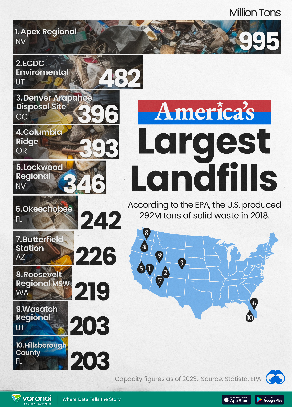
Map: Where Are America’s Largest Landfills?
According to the EPA, the U.S. produced 292 million tons of solid waste in 2018, of which 150 million headed to some of the largest landfills in the country.

Map: Where Are America’s Largest Landfills?
This was originally posted on our Voronoi app. Download the app for free on Apple or Android and discover incredible data-driven charts from a variety of trusted sources.
We map out America’s largest landfills, based on their total capacity (measured in millions of tons) for solid waste. Data for this graphic is sourced from Statista and is current up to 2023.
According to the EPA, the U.S. produced 292 million tons of solid waste in 2018. Of that, about 150 million tons headed to the country’s landfills. It would take more than 600 of the largest cargo ships (by dead weight tonnage) to move this much material at once.
Ranked: America’s Largest Landfills
Opened in 1993 and located 25 minutes from Las Vegas, Apex Landfill is believed to be one of the world’s largest landfills by both area and volume.
It spans 1,900 acres, or roughly the size of 1,400 football fields. Given its vast capacity, the landfill is expected to be able to accept waste for over 250 years.
Here are the top 10 largest landfills in the country.
| Rank | U.S. Landfill | State | Capacity (Million Tons) |
|---|---|---|---|
| 1 | Apex Regional | Nevada | 995 |
| 2 | ECDC Environmental | Utah | 482 |
| 3 | Denver Arapahoe Disposal Site | Colorado | 396 |
| 4 | Columbia Ridge | Oregon | 393 |
| 5 | Lockwood Regional | Nevada | 346 |
| 6 | Okeechobee | Florida | 242 |
| 7 | Butterfield Station | Arizona | 226 |
| 8 | Roosevelt Regional MSW | Washington | 219 |
| 9 | Wasatch Regional | Utah | 203 |
| 10 | Hillsborough County | Florida | 203 |
In a 2021 PBS interview, a spokesperson for Apex Landfill reported that the facility captured and treated enough landfill gas to power nearly 11,000 homes in Southern Nevada.
In fact, landfills can create electricity through a process called landfill gas (LFG) recovery. When organic waste decomposes, it produces methane gas which can be captured and purified to create fuel for generators.
As it happens, methane gas from landfills is the third-largest source of human-related carbon emissions, equivalent to 24 million gas passenger vehicles driven for one year. Its capture and treatment is a significant opportunity to combat emissions.

-

 China2 weeks ago
Comparing New and Current U.S. Tariffs on Chinese Imports
-
 Mining2 weeks ago
Visualizing Copper Production by Country in 2023
-

 Brands2 weeks ago
How Popular Snack Brand Logos Have Changed
-
 War2 weeks ago
Visualized: Aircraft Carriers by Country
-
 Cannabis2 weeks ago
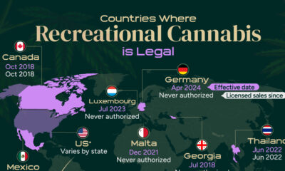
Mapped: Countries Where Recreational Cannabis is Legal
-

 Business2 weeks ago
Charted: How the Logos of Select Fashion Brands Have Evolved
-
 population2 weeks ago
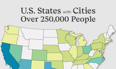
Mapped: U.S. States By Number of Cities Over 250,000 Residents
-

 Crime2 weeks ago
Visualizing Global Losses from Financial Scams